
The Zionist Death Grip On The United States Government Greg Reese | Infowars.com April 30th…
Appendix 93: Is Dr. Eric Karlstrom Targeted, Tortured, & Gangstalked Due to His Scientific-Environmental-Political Activism? Some Relevant Articles, Letters, Presentations, Notes, Etc. (2006-2013)
New World Order
Articles & Interviews
[pfc layout=”layout-one” cat=”16,17, 41″ order_by=”date” order=”DESC” post_number=”400″ length=”0″ readmore=”” show_date=”true” show_image=”true” image_size=”full”]
Toto Enterprises, Inc. (Websites of Professor Eric T. Karlstrom)
The Treasonous War Against Freedom and G5 (Global Government Gangstalking Genocide GESTAPO)
https://erickarlstrom.com
Gerald Massey: “They must find it difficult. Those who have taken authority as the truth, rather than truth as the authority.”
Webmaster’s Introduction: I recently received the following email from a lawyer and TI after sending him links to my websites. In order to “test” Mr. Bean’s hypothesis that I am targeted, stalked, and tortured due to my activism relating to water and related environmental issues in the San Luis Valley, Colorado, I include various letters I wrote to officials regarding this and related issues below. My severe and malicious targeting began in 2013. The environmental issues I was involved with between 2006 and 2013, as documented below, include:
1) Citizen response to proposed drilling of three 14,000′ deep gas test wells on the Baca National Wildlife Refuge.
2) Citizen efforts to preserve water quality in the San Luis Valley aquifer and in local Crestone/Baca drinking water.
3) Attempts to keep local trails and access to public lands from being closed off by local individuals and groups.
The various groups that I/we would have been interacting with during this time period include:
AquaSmart (and Monsanto?) (makers and distributors of SeaQuest/OPP)
Baca Grande Property Owners Association Board of Directors
Baca Grande Water and Sanitation Board of Directors
Baca National Wildlife Refuge
Colorado Department of Public Health and Environment
Colorado Oil and Gas Conservation Commission
ConocoPhillips
Crestone Spiritual Alliance
Lexam Explorations, Inc. (and ENSR)
Manitou Foundation
National Park Service Northern Entrance Advisory Council
Saguache County Board of Directors
San Luis Valley Citizen’s Alliance
San Luis Valley Ecosystem Council and Energy Minerals Law Center
Special Services District Management, In (oversees BGW&S)
Special Study Group
U.S. Fish and Wildlife Service
Water Watch Alliance
Western Res. Resources Council
If all or part of these groups were engaged in illegal or criminal activities that I and my fellow citizen activists were in the process of exposing, it becomes easier to understand why someone or some group might have watchlisted me with DHS to protect themselves from further scrutiny. Powerful elites generally prefer to shoot the messenger rather than listen to the message.
Although my efforts in any or all of these issues together could have been the cause of my being watchlisted with the Department of Homeland Security and then covertly tracked, targeted, and tortured since 2013, my gut level feeling is that it was my efforts to keep local trails open in 2012 and 2013 that most probably led directly to my being secretly watchlisted by DHS.*
(* See explanation at bottom of page).
It is possible that many serious crimes, up to and including willful murder, and other abuses of power are exposed in the documents below.
Here is Texas lawyer Thomas S. Bean’s message to me of 6/13/21:
“Thanks Eric…..I’ll hit those links. Just briefly looked at your story. Doesn’t surprise me that they probably targeted you for your activism concerning the water issue. After all….trillions of dollars worth of water jeopardized by mere gas exploration and extraction, would definitely put you on a bad list for neutralization. Has anyone else tied to that water issue-site, been reporting any targeting?
Sorry to hear the stalking followed you across the Mexican border. I had always counted on Mexico as a retreat site, but I don’t know now. Who wants gang stalking in a foreign country not famous for upholding civil rights. Mexican cops could easily be bought to conduct some enhanced torture and no one would lift a finger about that. Knew a guy named Geral Sosbee (former FBI agent whistleblower) who also got targeted across international borders. He used to live in Brownsville, Texas, and would cross the border into Mexico to sleep at his girlfriend’s home so he could get some sleep.
I got targeted for 35 years. I moved a lot. I was surprised it followed me from South Dakota to Austin, Texas. Then fled Austin, living out of my truck. Then, tortured in Sioux Falls, SD, forcing me to abandon my apartment……once again….I lived out of my truck for six years. Avoided some of the torture techniques by living out on fed lands….but, they could still tamper with my sleep. Like Geral Sosbee, I got chipped with an RFID Verichip inserted through my nasal cavity to sit near the optic nerve near my eye. That really, really, really…..pissed me off. Especially when they tampered with my course of medical care over and over and over.
In 2006, The War Commissions Act was signed. This new enabling law can be interpreted to legalie torture of any “enemy non combatants” including US citizens. That law creates a legal issue for judges, but…..hey…..who’s gonna be able to prove standing and party in interest?
It’s a tough life as a TI. After many set ups and operatives…it’s very hard for a TI to trust anyone….after all, they can pretend to be a TI. I’m sure the forums discussing gang stalking are loaded with lying operative wackos.
You can trust me and Geral Sosbee. We’re true blue TI’s…both chipped and both licensed in Texas as lawyers. Imagine that…the most litigious country in the world, and two Texas lawyers got no relief from all this? How could that be? It’s a strange and unpredictable New World Order type of Commie control.
If I’m in Colorado, I’ll drop you a line. You might want or need company with someone who knows personally what you endured. Again, there isn’t much we can do. I understand if you don’t trust anyone: they want you alone because you’re more vulnerable…so they’ll do what they can to keep you socially isolated and suspicious. Be forewarned, there are operatives who are claiming to be TI’s. One is James Lico.
Congress seems indifferent and The ACLU only seems to be controlled and not proactively throwing their lawyers behind any sort of litigation with Discovery. Isn’t that odd or suspicious? You would think, The ACLU, would be all over these programs…no? Last ACLU I contacted got neutralized on a domestic disturbance, and got fired. Another guy I contacted got sick and died (he was working National Security issues and was closer to the ACLU HQ shot-callers). Hmmm…methinks litigation could be seen as a threat requiring some Executive Action.
Don’t mean to be glib but, it sure is a surprising and bizarre world we live in. I never thought the right wingers were this crazy or could manipulate the justice system this well. I suspect the mind control technology has been deployed as a defensive system to prevent the justice system from working. Who frigging knows anymore.”
Thomas S. Bean (no phone number….I avoid cell phones).
_____________________________________________________________________________________________
Saguache County Board of County Commissioners April, 2013:
Thank you for letting me speak on this issue dear to my heart. I have climbed all the peaks that rim the spectacular Cottonwood Creek watershed at various times and I know how beautiful the area is. I still hike up there regularly and was up there this past Sunday.
I’d like to speak on behalf of the 300 million Americans who own Cottonwood Creek, Cottonwood Creek trail, Cottonwood Creek watershed and all our public lands and who are not able to be here to speak on their own behalf. (Please see p. 4 and 5 of my letter that shows a map of the drainage)
As you know the historic Tranquil Way bypass road is one of two roads that has historically provided access to the scenic wonders of the Cottonwood Creek watershed. This road has been used by the community and by outsiders for well over 20 years. It provides a way to get to this watershed and the KTTG stupa that does not involve driving on the slow, relatively poorly maintained “old mine road” or “Dream Way.” This more accessible route is important in case of emergencies, such as fire, health emergencies, etc.
In 1998, 2001 and 2002, a German family, the Greenways purchased the lot that this road goes through (4323) and the two adjoining lots. Then they consolidated the lots. In Christmas, 2011, they or their local surrogates emplaced large boulders on the road, blocking it off from public use. I am told they consulted a lawyer first. See pages 3 and 4.
However, in my opinion and that of many other concerned locals, the Greenways have blocked this road illegally. At least two Colorado laws require that such public highways, even if they occur on private property, must be officially vacated by County officials prior to changing their historic land use.
Saguache County Resolution 96-G-7 Reception No. 316837, passed September 17, 1996, is “A Resolution Identifying and Affirming All Public Access Roads Within Saguache County.” It states that “all public roads located within Saguache County, Colorado that have not been heretofore publicly vacated by the BOCC are hereby designated public highways”. The resolution defines public roads and public highways to include: “highways, roads, mining roads, logging roads, wagon roads, trails, horse trails, hiking trails and footpaths.” Since the Tranquil Way bypass road was certainly in existence when this law was passed, this law evidently applies to this road, as it also certainly applies to the Cottonwood Creek trail and “the Old Mine Road.” The Tranquil Way bypass, then, needs to be considered a “public highway” under 96-G-7 and therefore would need to be officially vacated by the County Commissioners prior to being blocked off.
6) Colorado Revised Statute (CRS) 3028-110 1(d) states: “The acceptance, widening, removal, extension, relocation, narrowing, vacation, abandonment, change of use, or sale or lease of or acquisition of land for any road, park or other public way, ground, place, property, or structure shall be subject to similar submission and approval (by the planning commission), and the failure to approve may be similarly overruled.”
7) CRS 30-28-110 defines a “complete location and extent application process” that involves six steps: 1) Complete Application Submittal, 2) Completeness Review, 3) Applicant Revisions for Completeness, 4) Schedule Hearings, 5) Internal/External Review by County Staff and Referral Agencies, and 6) Planning Commission Hearing. Note that the above Colorado statute requires that a specified application must be complete, a public hearing must occur, and the application must be approved by the County Planning Commission prior to a major land use change such as the one that has occurred. Since this law has not been followed, the public hearing has not occurred, and there has been no formal approval of the land use change, the County Commissioners are, in my opinion, legally obligated to instruct the Greenways to remove the boulders from the Tranquil Way bypass road until the proscribed legal process is followed and official approval is obtained.
As you perhaps recall, in 2008, the Crestone Spiritual Alliance/Northern Access Team, comprised of many of the same individuals as the Cottonwood Study Group, unilaterally closed five trails along the eastern margin of the Baca subdivision. They claimed that because Manitou Foundation owned a small strip of land at the base of these public trails this gave them right to close off public access to these public lands. Among these trails were Cottonwood trail and Spanish Creek trails. I’m told that there is now again an (illegal) no trespassing sign at the base of Spanish Creek and I have included in my letter to the Commissioners my recent photo of the “No Access to Cottonwood Trail” sign now posted at the Greenway’s home where the Tranquil Way bypass is blocked. So it seems that we are nearly back to where we started in 2008.
In 2008, small group of locals formed a group called “Save Our Trails” and appealed to the commissioners to review their own County resolution 96-G-7 (No. 316837) which clearly stipulates, as above, that public highways (including footpaths) may not be closed, even if portions of those highways cross private land.
Clearly, the current situation very closely resembles that of 4 years ago. Clearly, different people have different and strongly-held opinions on these matters. I have included in my letter, emails I have received from local community members since August 17, when I was restored to today’s agenda. Most individuals do not support the unilateral and illegal blockage of the Tranquil Way bypass road.
I suggest that especially in controversial matters such as this that involve closure of historic public highways, the County Commissioners are obligated to follow the Colorado laws that apply. In my opinion, this entails: Step 1): Immediately instruct the Greenways to remove the boulders that block the Tranquil Way bypass road. Step 2): Instruct the Greenways to initiate the six-step application and public hearing process with the Planning Commission if they still wish to close the Tranquil Way bypass.
If the Commissioners feel they need to research the matter further prior to making a decision, I request they conduct the needed legal research and then put me back on the agenda as soon as possible, based on maintaining the rule of law in our county and upholding these Colorado statutes.
Thank you, do you have questions or comments?
___________________________________________________________________________________
Saguache County Board Of County Commissioners March 19, 2013
Presentation to BOCC by Concerned Baca Residents regarding the issue of the closing of the Tranquil Way bypass road; Eric Karlstrom, spokesman
Many of us in the Crestone/Baca community are concerned that the unauthorized blocking of the so-called “Tranquil Way bypass road,” that occurred a little over one year ago, may have been illegal. We are also concerned that the closure of this road, used by the public for some 37 years, causes a loss of public access of public land and may also contribute to increased fire and emergency danger for residents in the southern part of Chalet II in the Baca Grande subdivision. Since I made my first presentation to the BOCC on August 21, 2012, I have made numerous presentations (with accompanying written statements) to the Saguache County Commissioners, the Crestone/Baca Planning Commission, the Baca Grande Water and Sanitation District Board and the Baca Grande POA Board. Again, our major concerns are: 1) the closing of this approximately 80-yard road segment seems to have been done without a public process, as legally required by three state and county laws (CRS 43-2-201, Saguache County Resolution 96-G-7 and CRS 30-28-110) or with the approval of the Baca Grande POA Board or E&AC Committee. 2) The blockage of this road reduces public access to public land, including the U.S. Forest Service and Sangre de Cristo Wilderness Area in the vicinity of Cottonwood Creek and Spanish Creek watersheds, and 3) Closing of the road creates may have increased health, fire, safety, and emergency access hazards, especially to those in the southernmost part of the Baca subdivision.
At this point in the revelation and discovery process, I would like to present to the Saguache County Commissioners a documentary record that I have put together on this issue. I am providing you with a notebook of materials that includes:
Written statements/presentations that I have made to the BoCC (4 statements), POA board (2 statements) and Crestone/Baca Planning Commission (1 statement) in 2012 and 2013.
Various letters and emails I have received from concerned residents regarding this issue. These letters confirm that this connecting road segment was used by the public very shortly after it was built as a road/utility easement in 1975 by BGW&S (Ellie Muller’s messages). A new letter by Tyrell Tucker documents that he has been using this road to access the Cottonwood Creek trail area since the late 70’s.
(Tucker states: “I have used the connecting road for access to the Old Mine Road since the late 1970’s. I understand that this connecting road was, and is, called the Tranquil Way road. There were no indications that this was in any way through private property.”). In addition, letters from U.S. Forest Service Fire Management Officer, Jim Jaminet and local resident Clem Gasseling express concern regarding the increased inability to move men and equipment into and out of this area in the event of a serious fire. And other letters express concern about loss of public access to public land in the vicinity of Cottonwood Creek, Cottonwood Trail, and the many glorious 14’er and 13’er mountains accessible from the Cottonwood watershed (including Crestone Peak and Crestone Needle). Clearly, recreational interests are adversely affected by the blockage of this road. A 2008 study determined that the average hiker/climber who visits our community contributes an average of $248/day to our economy.
Copies of two easement agreements recorded on January 12, 2012 between the Baca Grande Water and Sanitation District and Ulrike Greenway. Searches by Wendi Maez and Rebie Hazard of the Saguache County Abstract Co. did not turn up any easement agreements prior to 2012 that pertain to this road. Two diagrams of the connecting road accompany the 2012 easement agreements. The surveyed map by Billy Vigil (8/14/09) included in #370911 refers to this connecting road segment as “existing road.” #370912 refers to an earlier map (Exhibit A) of the 25’ Utility and Driveway Easement. These agreements indicate that on November 5, 2011, Baca Grande Water and Sanitation District paid $5000 to Ulrike Greenway, and Greenway thereby granted BGW&SD an easement to “construct, install, reconstruct, operate, use, maintain, repair, replace and/or remove certain water and sanitary sewer improvements and appurtenances thereto (Improvements), in through, over, under and across certain parcels of real property” (Number 320911). On November 18, 2011, Greenway paid $10 to BGW&S, and BGW&S granted to Greenway a “partial vacation of easement” in which the district agreed to vacate and abandon all right, title, interest, claim and demand in that portion of the Utility and Driveway Easement as recorded in the real property records of Saguache County, Colorado at Reception Number 220530, Nook 372, page 919. Both easement agreements were recorded by the Saguache County Clerk on January 12, 2012 within two minutes of each other, with 370911 being recorded a 11: 42 am and 370912 recorded at 11:44 am.
Copies of related documents, including 1) a story from the April, 2005 Crestone Eagle (“Manitou Institute: Spirit and Nature”). Maps in this article show that the upper part of the “Tranquil Way bypass road” crosses POA Greenbelt, 2) the petition to vacate a road or public way in Saguache County, petitioner Duane E. “Gene” Hollenbeck, to be considered by the BOCC in April, 2013, 3) a letter to the BOCC from the Cottonwood Study Group dated 4/25/12, and 4) two letters to the Saguache BOCC from the Save Our Trails group that date to September and October of 2008.
Legal history of Baca Grande (Chalet II) lot 4323. Included in this section, is a note from Rebie Hazard of the Saguache County Abstract Co. in which she states: “I also find no easement was recorded during the time the Rostas owned the property.” (Lot 4323, which the Rostas owned between November 20,1981 and March 31, 1998, when it was purchased by the Ulrike M. Greenway).
Photos include three photos of the boulders that now block Tranquil Way Bypass Road and one photo of a posted sign on Greenway property, stating “No Access to Cottonwood Trail,” (photos taken in July, 2012).
Pertinent maps of the area showing:
1) This connecting road segment is shown on a modern Google map and
2) The 2001 “Sangre de Cristo Wilderness and Great Sand Dunes National Park Trails” map.
3) This connecting road segment, built in about 1975 by BGW&DS, does not appear on the 1967 USGS 7.5 minute Crestone Quadrangle map. However, this topo map shows pre-1967 roads on land now owned by Greenway. Indeed, it seems that the Greenways built their home directly on top of one of these roads.
4) Two maps, including Scoping Map of the Great Sand Dunes National Park and Preserve, that show that a large tract of Forest Service Land, called “The Baca Mountain Tract,” occurs between the Manitou Foundation land and the Sangre de Cristo Wilderness.
Pertinent laws that pertain to this issue include:
CRS 34-2-201 states: “The following are declared to be public highways: (c) All roads or portions thereof that have been used adversely without interruption or objection on the part of the owners of such lands for twenty consecutive years.” Our documentary record indicates that the “Tranquil Way bypass road” has been used continuously by the public from 1975 until it was closed in January, 2013. This is a period of 37 years. In addition, this road had met legal qualifications as a public road a full three years before Greenway purchased lot 4323 (in 1998).
Saguache County Commissioners passed a resolution on September 11, 1996, (96-G-7 Reception No. 316837) that states:“all public roads located within Saguache County, Colorado that have not been heretofore publically vacated by the BOCC are hereby designated public highways.” This resolution defines public roads and public highways to include: “highways, roads, mining roads, logging roads, wagon roads, trails, horse trails, hiking trails, and footpaths.”
CRS 30-28-110 1(d) states: “The acceptance, widening, removal, extension, relocation, narrowing, vacation, abandonment, change of use, or sale or lease of or acquisition of land for any road, park or other public way, ground, place, property, or structure shall be subject to similar submission and approval (by the planning commission), and the failure to approve may be similarly overruled.”
CRS 30-28-110 defines a “complete location and extent application process” that involves six steps:
Complete Application Submittal
Completeness review
Applicant Revisions for Completeness
Schedule Hearings
Internal/External Review by County Staff and Referral Agencies
Planning Commission Hearing.
We have a curious situation here. Yes, this road was originally put in as a water line 1975 by BGW&S and they have done a fine job of maintaining it over subsequent years, making it large enough so they could move their trucks and equipment into the area of the Cottonwood Tank next to Cottonwood Creek. And yet today, BGW&S does not seem to be interested at all in being part this discourse. We now know that the road crosses POA Greenbelt and yet, POA Board members have only admitted this fact in the last two months. And while this issue is certainly within their purview and authority, they don’t seem to want to get involved either. And finally, up until now, the Saguache County BOCC and the Crestone/Baca Planning Commission have not shown any interest in resolving this issue either, although state and county laws would seem to dictate that they have jurisdiction in this issue.
We are left to wonder: Are there serious conflicts of interest involved in this issue? Could these conflicts of interest pertain to the Manitou Foundation’s plan to limit human activity in the so-called Manitou Preserve as shown in the map included in the April, 2005 Crestone Eagle article? If so, does a non-profit organization have the legal authority to over-ride the prevailing laws of the land and make decisions regarding land-use designations?
In lieu of the facts and pertinent laws presented in this notebook, then, we local residents feel the Saguache County Commissioners are legally obligated to call for an official public process in order to determine, one way or another, if this connecting road meets the legal requirements of a public road. (Obviously, we believe it does). A public hearing would allow for public input and a vetting of the various viewpoints. We believe the County Commissioners should authorize a public hearing on this matter to be conducted by the Crestone Baca Planning Commission as per CRS 30-28-110. Certainly, it would be fair and logical if the BOCC consider the legality of the vacation of this road at the same time that they examine the Hollenbeck road issue.
Because a public hearing needs to be held before a public road can be legally closed, we believe the Commissioners are required to instruct the Greenways to remove the boulders from this road until that hearing has occurred.
____________________________________________________________________________________________
February 19, 2013:
Items for POA Work Session (2/7/2013) presented by Dr. Eric Karlstrom, Emeritus Professor of Geography, California State University.
Regarding the issue of the closure of Tranquil Way bypass road by the Greenway family in January, 2012, I would like to submit the following new information:
1) Two maps shown in an April, 2005 Crestone Eagle article entitled “Manitou Institute: Spirit and Nature” include:
The first map (“Manitou Habitat Conservation Program- Mountain Tracts”) shows the approximately 300-yard strips of Manitou-owned land immediately surrounding Willow, Spanish, and Cottonwood Creek designated as “Manitou Preserve.” This map also indicates under the heading “Under Conservation Easement” that the Manitou Preserve areas (dark gray) are to have “NO Development,” whereas areas with spiritual centers (light gray) are to have “limited development,” and two other designations also specific restrictions, “General Development” areas (including Chamma Ling and Vajra Vidya spiritual centers) are limited by “Total Permitted sq. ft. build out = 1%, and “Special Use Zone” is “Allowed development determined on a case-by-case, site specific basis.
The second map (“Properties Owned or Conveyed by Manitou, in relation to the greater Baca Grande”) shows all Manitou land as dark gray (Under Conservation Easement) and also shows that the area just north of Cottonwood Creek and just west of “Dream Way” is POA Greenbelt.
The Eagle article states:
“Over the last 17 years, some 750 acres have been granted or sold by Manitou, and approximately 950 acres remain. Of this, about 350 acres will stay in Manitou’s stewardship, under a conservation easement as Preserve (NO development). Another 150 acres, designated as Limited Development (allowing one small solitary retreat cabin per 20 acres), is the home of Manitou’s Solitary Retreat Hermitage Program. Two cabins have been built, and five more are permitted.
In the MHCP, the best and only locations for the more active purposes of the spiritual and educational centers were identified as General Development areas, with maximum building and use parameters pre-determined. The allowable sq. ft. build-out is 1% of that of the property, with a total disturbance area (for parking, trails, utilities, etc.) capped at 15%. At present, Manitou has five larger parcels (35+ acres), four smaller parcels (3 – 24 acres) and a few Baca Grande lots remaining for granting or sale, some under conservation easement and others not.
Acquiring land from Manitou is a rigorous process, and an estimated 90% of those approaching Manitou for land are screened out by themselves or the process, a discernment by both that often takes a year or two. They begin with a Pre- Application outlining their intentions for use of the land. Manitou staff screens these for a possible match, and the vast majority are ruled out due to unsuitable plans for this locale.
The Manitou Board reviews Pre-Applications that appear to fit with its mission and the carrying capacity of the land, and invites full applications from those that seem promising. The full application requires a much deeper level of details and long term planning, and there is considerable attrition of applicants at this phase, as well. The Board, with input from Manitou’s E&A Committee reviews the style, profile and substance of applying projects in making its final decisions of which land grants they approve.
In accepting ownership of Manitou land, grantees and purchasers become partners with Manitou, working collaboratively on development and environmental stewardship plans, and any mitigations required to minimize the impacts of human activities and optimize the health and safety of the land. Grantees submit annual reports to Manitou staff, and the E&AC completes planning and site visits to monitor and support development and land use in alignment with the approved purposes of the land grants, or terms of sale, and the requirements of conservation easements.
Other partnerships have arisen from time to time to address issues of our area as a whole. An early special project, was a collaboration with the Crestone/Baca Land Trust in it’s formative years, Go Colorado Fund, the Baca Grande POA and The Nature Conservancy, which now holds an easement preserving sensitive wetlands in the Grants, that were previously lots to be developed. It took several years, and was achieved by the diligence and hard work of many individuals and organizations.
In Present Time & for the Future
Manitou’s mission of supporting the cultivation of spirit and the preservation of nature is in its second decade, and the Baca is in its third. As the Manitou properties and the Baca Grande grow and develop, we have no end of opportunities to proactively re-create and co-create a healthy community – socially, environmentally and spiritually. It’s not always easy, the vision is unique and the lessons are many. The more individuals and families, spiritual centers and educational projects that make the Baca their home, the more compelling it becomes to find cooperative ways to communicate and to live and work together.
Overcoming mistakes of the past, facing the obstacles and issues of the present with creativity, and designing the future to our mutual benefit – it is a tall order! But, it’s worth every effort in exchange for the joys and benefits of living here, in this unique and amazing place of spirit and nature.
4) Now the issues become more clear to me: It seems that re: the issue of land-use designations, Manitou Foundation has attempted to usurp the functions of local government. It has apparently enlisted the aid of our local agencies and officials (Baca Grande Water and Sanitation District and the Baca Grande POA Board and the Saguache County Commissioners) to allow them to bypass (and break?) the federal, state and county laws that these same agencies are supposed to uphold. Manitou Foundation is a non-profit organization. It does not have the legal authority to make land use designations via conservation easements without going through the legal approval processes of Saguache County or the Baca Grande Property Owners Association.
5) I now believe the Greenway’s (or was it BGW&S?) unilateral and illegal closure of the Tranquil Way bypass road is an example of how the Manitou Foundation operates unilaterally in our County and community, bypassing, and therefore often breaking, federal, state, and county laws.
My conclusions are as follows:
The Tranquil Way bypass road was put in as a water line in 1975 but has been used by the public for some 37 years (only 20 is required to qualify as a public road under CRS 43-2-201). This approximately 80-yard connecting segment between Tranquil Way and Dream Way was heavily used by the public between 1975 and 2012 as a way to access the southern portion of Dream Way, the Cottonwood Creek trail and drainage area that access the Sangre de Cristo Wilderness Area and several spectacular 14er and 13er peaks, and the Tashi Gomang Stupa.
The 80-yard road segment traverses not only Greenway property but also BGW&S property and POA greenbelt. No easements were recorded for this road until January, 2012, at which point BGW&S and the Greenways sold each other easements which may not be legal. However, the POA Board and the E&AC seem not to have been involved in granting variances for this road.
The following state and county laws have not been upheld by local officials. These include:
1) CRS 43-2-201 (the “Public Highways” law):
“The following are declared to be public highways: (c) All roads over private lands that have been used adversely without interruption or objection on the part of the owners of such lands for twenty consecutive years.”
2) Saguache County Resolution 96-G-7 – also defines public roads as roads used by the public that have not been officially prior to 1996.
3) CRS 30-28-110 mandates that a 6-step public process be followed before changing a land use such as blocking a public road.
_____________________________________________________________________________________________
January 25, 2013:
Water Watch Alliance Mission Statement
Introduction
Water Watch Alliance (WWA, aka known formerly as San Luis Valley Citizen’s Alliance) is a non-profit organization of volunteers that formed when the Crestone/Baca community learned, in August, 2006, that a Canadian company, Lexam Explorations, Inc., had applied for permits to drill two 14,000’ gas test wells on the new Baca National Wildlife Refuge (BNWR). Our initial mandate was to research the potential impacts of gas mining in rural areas and write “Best Management Practices” recommendations for the BNWR. Our recommendations were subsequently written into the drilling permits issued by the Colorado Oil and Gas Conservation Commission (COGCC). Our next objective was to begin educating others in our community and region about the potential impacts of gas drilling. Thus, we organized two showings of the new film, “A Land Out of Time,” which shows the scope and scale of gas drilling which has dramatically escalated all through the Rocky Mountains since 2001. At these well-attended events, we shared what we had learned with our local community.
Based on the documented impacts of gas production elsewhere in other areas in the Rocky Mountains we are now convinced that full-scale gas production in the San Luis Valley would be highly disruptive and incompatible with the values and the qualities of our local environment that brought us here and that we hold dear. We feel it is our responsibility as stewards of this sacred area to do our best to protect the health and quality of our air and water, our communities, the natural ecosystems, and not least, our profound silence, which is so essential for the many spiritual groups located in this beautiful and pristine area. Whereas Lexam and their much larger partner, Conoco-Philips, now have designs to extract the potentially billions of dollars worth of natural gas (and/or coal bed methane gas) beneath our Valley floor, we feel it is our responsibility to protect the much more valuable fresh water (potentially many trillions of dollars) that is also stored in the unconfined and confined aquifers of the San Luis Valley. Thus, to preserve and protect this priceless aquifer and our priceless, pristine, and sacred environment for the benefit of current and future generations, it is our mission to find ways to forestall and prevent the proposed gas drilling.
Accomplishments of Water Water Alliance:
1) Four of us spent a day with Peggy Utesch of Grand Valley Citizen’s Alliance in the Rifle/Silt area. During this day, we toured many gas wells, learned of adverse health impacts of gas drilling on local human and non-human communities, and began accumulating many publications that had already been written on gas drilling impacts throughout the West.
2) We toured the BNWR with Ron Garcia and one of our members, Lisa Cyriaks, was the official contact between our community and Ron.
3) Based on the referencing written reports of OGAP and other non-profit agencies, we wrote and submitted “Best Management Practices” Recommendations to Ron Garcia of Baca National Wildlife Refuge. Most of these were subsequently written into the permits granted by the Colorado Oil and Gas Conservation Commission.
4) We organized two community showings of “A Land Out of Time” at Jillian’s studio in Crestone. At these events, we educated local citizens on the geological context and potential impacts of gas drilling. For this event, we distributed a list of “Talking Points” which we wrote and also prepared graphics, including geological cross-sections of the Valley.
5) In cooperation with the San Luis Valley Ecosystem Council, we sent out a fund-raising letter in December, 2006, that netted $8700 in local contributions. Of this, $3500 was spent on retaining environmental lawyers, Brad Bartlett and Travis Stills, of the Energy Minerals Law Center in Durango, Colorado.
6) The lawsuit subsequently filed by against BNWR forced the BNWR to (belatedly) initiate NEPA (National Environmental Policy Act)/Scoping Process. By allowing the permitting process to go forward prior to completing a NEPA process, the BNWR had not been in compliance with federal law.
7) We have contacted appropriate politicians (Senator Salazar, Congressman Salazar, Colorado Rep. Gail Schwarz, etc.), lobbying them on behalf of protecting our community.
8) Based on consulting with an environmental expert in the oil and gas industry, we have developed a list of Actions/Tasks designed to prevent drilling in our area.
9) We are in process of researching potential impacts of coalbed methane gas production as well as the complex series of water laws and compacts that govern use of water within the Rio Grande Basin. It seems insane and even criminal to deliberately contaminate the upper headwaters of the Rio Grande system as his water is a primary source of municipal and agricultural water for three states (Colorado, New Mexico, and Texas) as well as Mexico.
10) The splintering process seems to be commonplace in our community. Thus, two other groups, the SLVEC and a new San Luis Valley Citizen’s Alliance, are now also taking on this issue. Hopefully, our cause will be advanced by the activities of each of the groups. WWA alliance can continue to contribute to the effort because of several factors: a) it has the longest history of involvement with the issue, b) its membership includes Dr. Eric Karlstrom, with over 30 years of experience as a physical and environmental geographer, c) Dr. Karlstrom has assembled a library of resource materials regarding this issue, d) through Lorain Fox-Davis, WWA has access to advice from the head environmental consultant in the Canadian oil and gas business.
_________________________________________________________________________________________
February 7, 2013:
Items for POA Work Session (2/7/2013) presented by Dr. Eric Karlstrom, Emeritus Professor of Geography, California State University.
Regarding the issue of the closure of Tranquil Way bypass road by the Greenway family in January, 2012, I would like to submit the following new information:
1) Two maps shown in an April, 2005 Crestone Eagle article entitled “Manitou Institute: Spirit and Nature” include:
The first map (“Manitou Habitat Conservation Program- Mountain Tracts”) shows the approximately 300-yard strips of Manitou-owned land immediately surrounding Willow, Spanish, and Cottonwood Creek designated as “Manitou Preserve.” This map also indicates under the heading “Under Conservation Easement” that the Manitou Preserve areas (dark gray) are to have “NO Development,” whereas areas with spiritual centers (light gray) are to have “limited development,” and two other designations also specific restrictions, “General Development” areas (including Chamma Ling and Vajra Vidya spiritual centers) are limited by “Total Permitted sq. ft. build out = 1%, and “Special Use Zone” is “Allowed development determined on a case-by-case, site specific basis.
The second map (“Properties Owned or Conveyed by Manitou, in relation to the greater Baca Grande”) shows all Manitou land as dark gray (Under Conservation Easement) and also shows that the area just north of Cottonwood Creek and just west of “Dream Way” is POA Greenbelt.
The Eagle article states:
“Over the last 17 years, some 750 acres have been granted or sold by Manitou, and approximately 950 acres remain. Of this, about 350 acres will stay in Manitou’s stewardship, under a conservation easement as Preserve (NO development). Another 150 acres, designated as Limited Development (allowing one small solitary retreat cabin per 20 acres), is the home of Manitou’s Solitary Retreat Hermitage Program. Two cabins have been built, and five more are permitted.
In the MHCP, the best and only locations for the more active purposes of the spiritual and educational centers were identified as General Development areas, with maximum building and use parameters pre-determined. The allowable sq. ft. build-out is 1% of that of the property, with a total disturbance area (for parking, trails, utilities, etc.) capped at 15%. At present, Manitou has five larger parcels (35+ acres), four smaller parcels (3 – 24 acres) and a few Baca Grande lots remaining for granting or sale, some under conservation easement and others not.
Acquiring land from Manitou is a rigorous process, and an estimated 90% of those approaching Manitou for land are screened out by themselves or the process, a discernment by both that often takes a year or two. They begin with a Pre- Application outlining their intentions for use of the land. Manitou staff screens these for a possible match, and the vast majority are ruled out due to unsuitable plans for this locale.
The Manitou Board reviews Pre-Applications that appear to fit with its mission and the carrying capacity of the land, and invites full applications from those that seem promising. The full application requires a much deeper level of details and long term planning, and there is considerable attrition of applicants at this phase, as well. The Board, with input from Manitou’s E&A Committee reviews the style, profile and substance of applying projects in making its final decisions of which land grants they approve.
In accepting ownership of Manitou land, grantees and purchasers become partners with Manitou, working collaboratively on development and environmental stewardship plans, and any mitigations required to minimize the impacts of human activities and optimize the health and safety of the land. Grantees submit annual reports to Manitou staff, and the E&AC completes planning and site visits to monitor and support development and land use in alignment with the approved purposes of the land grants, or terms of sale, and the requirements of conservation easements.
Other partnerships have arisen from time to time to address issues of our area as a whole. An early special project, was a collaboration with the Crestone/Baca Land Trust in it’s formative years, Go Colorado Fund, the Baca Grande POA and The Nature Conservancy, which now holds an easement preserving sensitive wetlands in the Grants, that were previously lots to be developed. It took several years, and was achieved by the diligence and hard work of many individuals and organizations.
In Present Time & for the Future
Manitou’s mission of supporting the cultivation of spirit and the preservation of nature is in its second decade, and the Baca is in its third. As the Manitou properties and the Baca Grande grow and develop, we have no end of opportunities to proactively re-create and co-create a healthy community – socially, environmentally and spiritually. It’s not always easy, the vision is unique and the lessons are many. The more individuals and families, spiritual centers and educational projects that make the Baca their home, the more compelling it becomes to find cooperative ways to communicate and to live and work together.
Overcoming mistakes of the past, facing the obstacles and issues of the present with creativity, and designing the future to our mutual benefit – it is a tall order! But, it’s worth every effort in exchange for the joys and benefits of living here, in this unique and amazing place of spirit and nature.
4) Now the issues become more clear to me: It seems that re: the issue of land-use designations, Manitou Foundation has attempted to usurp the functions of local government. It has apparently enlisted the aid of our local agencies and officials (Baca Grande Water and Sanitation District and the Baca Grande POA Board and the Saguache County Commissioners) to allow them to bypass (and break?) the federal, state and county laws that these same agencies are supposed to uphold. Manitou Foundation is a non-profit organization. It does not have the legal authority to make land use designations via conservation easements without going through the legal approval processes of Saguache County or the Baca Grande Property Owners Association.
5) I now believe the Greenway’s (or was it BGW&S?) unilateral and illegal closure of the Tranquil Way bypass road is an example of how the Manitou Foundation operates unilaterally in our County and community, bypassing, and therefore often breaking, federal, state, and county laws.
My conclusions are as follows:
The Tranquil Way bypass road was put in as a water line in 1975 but has been used by the public for some 37 years (only 20 is required to qualify as a public road under CRS 43-2-201). This approximately 80-yard connecting segment between Tranquil Way and Dream Way was heavily used by the public between 1975 and 2012 as a way to access the southern portion of Dream Way, the Cottonwood Creek trail and drainage area that access the Sangre de Cristo Wilderness Area and several spectacular 14er and 13er peaks, and the Tashi Gomang Stupa.
The 80-yard road segment traverses not only Greenway property but also BGW&S property and POA greenbelt. No easements were recorded for this road until January, 2012, at which point BGW&S and the Greenways sold each other easements which may not be legal. However, the POA Board and the E&AC seem not to have been involved in granting variances for this road.
The following state and county laws have not been upheld by local officials. These include:
1) CRS 43-2-201 (the “Public Highways” law):
“The following are declared to be public highways: (c) All roads over private lands that have been used adversely without interruption or objection on the part of the owners of such lands for twenty consecutive years.”
2) Saguache County Resolution 96-G-7 – also defines public roads as roads used by the public that have not been officially prior to 1996.
3) CRS 30-28-110 mandates that a 6-step public process be followed before changing a land use such as blocking a public road.
_________________________________________________________________________________________
January 24, 2013:
Baca Grande POA Board Jan. 24, 2013
Tranquil Way bypass road issue by Concerned Baca Residents;
Eric Karlstrom, spokesman
Beginning with my August 21 presentation to the Saguache County Commissioners, I have made numerous presentations (including written statements) on behalf of local concerned Baca residents to the BOCC, the Crestone/Baca Planning Commission, the Baca Grande Water and Sanitation District Board and to you, the POA Board to explain why many of us in the Crestone/Baca community believe the unauthorized closing of the so-called “Tranquil Way bypass road” about one year ago, is illegal. Certainly, the closing of this 80-yard connecting road segment seems to have been done without the knowledge and approval of the E&AC in violation of POA Covenants and bylaws. In addition, it appears that the closing of this public road violates at least three state, federal, and county laws and has created a health, fire, safety, and emergency access hazard to Baca community members in the southernmost part of the Baca subdivision.
At the November 7, 2012 meeting of the Crestone/Baca Planning Commission and again at the December 4, 2012 meeting of the BoCC, several Baca community members and I provided notarized statements and evidence to prove that the so-called “Tranquil Way bypass road” has long met the definition of a public road. I include copies of these notarized statements that we also presented to Wendi Maez, Saguache County Land Use Administrator. These letters include the following statements by:
Ellie Mueller: “Our/my first use of the road in question was 1975 in our 1971 VW camper bus. The road was really rough. Tranquil Way was later smoothed out. By that time we had a Jeep…. There were very few roads in place….. In my humble opinion, closing, moving, etc., the right away sets a very concerning precedent for political, environmental, and emergency services reasons.”
Clem Gasseling: Clem quotes local Fire Chief Ben Brack as telling him that “he has informed the people that if he received a fire emergency call in that area, he may not be able to respond because he can not endanger his firemen and equipment with no available escape route.”
Eric Karlstrom: I stated I have personally used Cottonwood trail as early as 1986 and have often used the Tranquil Way bypass road for at least the last 12 years. I stated that while hiking I noticed the boulders blocking the road, either December 2011 or January, 2012. These dates, 1975 and 2012, then, provide the brackets for the time period, about 37 years, in which the public has used this road adversely to the interests of the property owners.
Marvin Ogden: Marvin stated that he “definitely recalls” using the “Tranquil Way bypass road when he was investigating the area with a friend in 1995 (or 17 years ago). “The road was passable at the time. Since then, I have used the road regularly many times during the year, mainly to go up to the Stupa.” He states that in July, 2012, he noticed small rocks on this bypass road and got out of his car to remove them. Mrs. Greenway “came running out of the house nearby followed by a man. She yelled at me in a loud angry voice, ‘This is our land, and you have no right to trespass on it.’ My response was: “I don’t see a sign that says no trespassing.” The man, also yelling, said “You dumb son of a bitch! I’m going to have you arrested for trespassing and I’m going to call the Sherriff.” I replied: “You can’t vacate a road unless you have the County Commissioners do it first. It doesn’t matter whether it’s private land or public land. As long as a road has been used for twenty years or more, which this road has been, then it is a road and it’s owned by the County.”
Frank McGregor: Frank states he has been using this road since 1998. He noted that “the closure of this road creates a variety of “negative impacts” related to a) access to a public water source (emergency access in case of fire), b) loss of secondary evacuation route for retreat centers from Dreamway Road (fire exit), and c) reduced access to Cottonwood Creek drainage hiking trail.”
Fire Management Officer, Jim Jaminet: stated there needs to be a well-considered evacuation plan and “it would be desirable from an emergency evacuation perspective to have the Tranquility Way bypass as an open route.”
We also submitted a petition with 9 signatures to the County Commissioners that calls on them to enforce the laws of the land and require the Greenways to remove the boulders from the road until they have completed the legal public vacation process required in CRS 30-28-110. We submitted this documentation to Wendi Maez at the Nov. 7 meeting. However, at the conclusion of the Nov. 7 meeting, Wendi Maez read the following resolution that the County Commissioners had made two days prior, on Nov. 5, 2012:
“Commissioner Pace made a motion that after reviewing Attorney Gibbons memo to the Board there has not been enough historical information presented showing proof that this is a public road – motion seconded by Commissioner Spearman – vote two ayes. Commissioner Joseph recused herself due to her affiliation with Manitou and the Cottonwood Study Group.”
This resolution leaves the door open for local citizens to provide the needed historical evidence to prove this is a public road. We provided that documentation at the Nov. 7 and December 4 meetings of the BoCC and I am now providing it again to the POA Board. We will continue to present the evidence and facts demonstrating that this is a public road.
Informed legal council recently related to two of us that the principle law that pertains in this situation is CRS 43-2-201 (Public Highways). This law states:
“The following are declared to be public highways: (c) All roads over private lands that have been used adversely without interruption of objection on the part of the owners of such lands for twenty consecutive years.””
This comes under the heading of Prescriptive Right-of-Way. A 2009 legal document by H. Keith Corey, PLS 13466 (970-244-1896) entitled “Road Right-Of-Way” states:
To establish a public highway across private property a party must show that (1) the public used the road under claim of right and (2) in a manner adverse to the landowner’s property interests; (3) the public use was uninterrupted for 20 years; and (4) the landowner had actual or implied knowledge of the public’s use and made no objection to such use. The public’s right results in an easement.
Our legal council points out that the Cottonwood and Spanish Creek trails are subject to this same 20-year statute and therefore are also public roads. Hence, the claim of the Manitou Foundation and Cottonwood Study Group that Manitou has the right to give permission for the public to utilize these public trails is erroneous and illegal.
At the Nov. 7 and Dec. 4 BOCC meetings and again today we are providing documentary evidence that the public has used this road for 20 years. Although CRS 43-2-201 is the appropriate law to determine a public road through adverse possession and public use, the County Attorney, Ben Gibbons, has repeatedly brought up RS 2477, a 19th century mining law that was repealed in 1976. Because this law refers to public roads across public land, we believe that reference to this law is essentially a “red herring” and serves mainly to confuse the public. In my previous meetings with the BOCC and the Planning Commission, I cited two other laws that apply here. These are 96-G-7 (No. 316837) and CRS 30-28-110. And I documented then that when the Greenways purchased the lot in question (Lot 4323) in 1998, this road had already been used by the public for over 20 years and no official easement had been recorded by previous owners.
I would like to add the following relevant information:
7) In 2006, the Greenways built their house on an old public road shown on the 1967 USGS Crestone 7.5 minute quadrangle map. Constructing a home on this “public road” without going through the public process required in CRS 30-28-110 seems to be a violation of the same three laws (CRS 43-2-201, Resolution 96-G-7 and CRS 30-28-110) as their subsequent blockage of the Tranquil Way bypass road.
In January, 2012, two easement agreements between the BGW&S and the Greenways were recorded at Saguache County. These documents are an apparent attempt to claim the right to a portion of the Tranquil Way bypass road that is currently owned in common with the Baca Grande POA and indeed, the residents of the Baca Grande POA These easement documents may not have legal standing because they did not involve the required review and approval/disapproval process with the POA Board. To date, the POA Board has not signed off on these agreements. Research may confirm that this unilateral act (which excluded POA approval) within the administrative boundary of the POA constitutes an ongoing violation of the Membership’s protective covenants and restrictions.
I include the two easement agreements (370911 and 370912). In these documents, the BGW&S and the Greenways granted easement agreements to each other for their respective portions of this 80-yard connecting road segment, with about 1/3 of the 80 yard segment crossing the Greenway’s property. A surveyed map by Billy Vigil, dated 8/14/09 (from 370911) refers to the “Tranquil Way bypass road” as the “existing road.” Whereas the Greenways purchased their easement agreement for $10, the BGW&S purchased their agreement for $5000. However, both of easement agreements may be null and void because the road in question met qualifications for a public road even before the Greenways purchased Lot 4323.
When the Greenway’s granted a “Partial Vacation of Easement” to the BGW&S on November 18,2011, no prior recorded easement agreement had been recorded to establish that the Greenway’s had any legal right to the road. Indeed, to re-interate, the “Tranquil Way bypass already met the qualifications for a public road as per CRS 43-2-201 prior to when the Greenways purchased Lot 4323 in 1998.
To try to sort out the chronology: On November 18, 2011, the Baca Grande Water and Sanitation District granted to Ulrike Greenway “A Partial Vacation of Easement” (370912) for the sum of $10 (paid by Greenway). The document states: “the District vacates and abandons all right, title, interest, claim and demand which the District has in and to that portion of the “Utility and Driveway Easement”, as in the real property records of Saguache County Colorado at Reception Number 220530, Book 372, page 919. A map on page 4 indicates that this easement pertained to approximately 1/3 of the “existing road;” i.e., the 1/3 that actually crossed the Greenway’s property.
On January 5, 2012, some 48 days after the BGW&S and the Greenways signed the “Partial Vacation of Easement” (370912), the two parties signed a “Utility Easement Agreement” (370911). In this agreement, the BGW&S paid $5,000 to the Greenways and the Greenways surrendered all rights to their portion of the road back to BGW&S. Note that when this agreement was made, the Greenways did not actually own the rights to the easement. For neither of these agreements were officially recorded by the County Recorder until 1/12/12 at 11:44 am by Melinda Myers.
Further, the “Utility and Driveway Easement” (370911) refers to the road in question as a “25’ wide utility and driveway easement located within the Baca Grande Chalets Unit Two Subdivision Tract “I” and Tract “C” shown on sheets 21 and 26 of 27, respectively on the Plat recorded on February 14, 1972, Reception No. 200839. The agreement (Partial Vacation of Easement, Reception Number 37092) was signed by Christine Canaly, President of the BGW&S Board and Ulrike Greenway and recorded by Saguache County Recorder Melinda Myers on 1/12/2012 at 11:44 am.
My interpretation: When BGW&S and the Greenways signed a “Partial Vacation of Easement” (370912) on Nov. 18, 2011, the BGGW&S granted easement rights to the Greenways for their 1/3 (about 30 yards) of the Tranquil Way bypass road. At that time, no official, recorded easement was in existence that established that the Greenways had any claim to an easement on that the road. Indeed, having been used by the public for over 20 years prior to the Greenways’ purchase of their Lot 4323, the road already met the criteria of a public road by legal definition (CRS 43-2-201, 96-G-7, and CRS 30-28-100).
Nevertheless, and notwithstanding that no previous recorded easement agreement showed that any entity had legal right to the road, the BGW&S and the Greenways later signed a Utility Easement Agreement” (307911) on January 5, 2012, some 48 days after BGW&S and the Greenway family signed the “Partial Vacation of Easement” (370912). In this second agreement, BGW&S paid the Greenways some $5000 and the Greenways relinquished whatever easement rights they had back to BGW&S. This agreement presupposes that the Greenways had previously obtained easement rights to the road and were in a position to sell them. However, they did not have easement rights at that time because the earlier agreement (370912) had not yet been recorded by the Saguache County Recorder. Hence, the Greenways received $5000 for selling something they did not at the time own. However, Melinda Myers, the Saguache County Recorder who was later recalled for election fraud, etc., facilitated the illegal deception by switching the order of the two easement agreements so that the first (Nov. 18) easement (370912) was recorded 2 minutes later than the second (Jan. 5) easement (370911).
In the second (370911) agreement the Greenways (The Grantor”) sold the BGW&S “a non-exclusive easement to construct, install, reconstruct, operate, use, maintain, repair, replace, and/or remove certain water and sanitation sewer improvements and appurtenances thereto.” The agreement granted to the BGW&S “the right of ingress and egress in, to, through, over, under and across the Premises for any purpose necessary for the construction, installation, reconstruction, operation, use, maintenance, repair, replacement and/or removal of the Improvements.”
However, despite the fact that the Greenways had received $5,000 and given up all claim to the Tranquil Way bypass road, they immediately blocked the road with large boulders.
13) This history indicates the complicity and probable illegal maneuvers of BGW&S.
Meryl Ennis sent out on email on Dec. 3, 2012, in which she stated that local Baca residents of the Serene Way area met on Dec. 2 with Zoe of KTTG. “The main result is that none of the people are in favor of a new road being cut to the upper old mine road. We were all in favor of visitors to the Stupa using the old mine road which KTTG has a permanent ease way from Manitou.”
Although the Greenways stated they intend to replace the boulders with a locked gate for emergency access purposes, this has not been done as of the present time. So the increased fire danger to the approximately 50 to 75 homes in the southern portion of the Baca development remains.
Baca property owner and former resident, Tyrell Tucker, informed me over the phone that he has been using the Tranquil Way bypass road since the early 1980’s and up until the time when the road was closed in January, 2012. Hence, we have ample proof that this road has been in continuous use for over 20 years.
Hence, the net result of the unilateral and illegal closing of the Tranquil Way bypass will probably remain the same for some time. These negative impacts are: 1) laws are being violated and very bad precedents are being set, 2) there is increased risk of fire danger to some 50 to 75 homes in the southern Baca subdivision because of the closure of this road, which served as an emergency access road, 3) there is reduced public access public land, in particular, to the Cottonwood Creek trail, the Cottonwood Creek watershed, nearby forest, as well as the Cottonwood Tank.
Thus, we feel that taxpayers of Saguache County and the citizens of this country will be best served if the County Commissioners and the POA Board enforce the appropriate laws (CRS 43-2-201 and 96-G-7) and require the Greenways to unblock the road until such time as they have gone through the public process required by CRS 30-28-110. I believe the POA Board has the authority and duty to resolve these problems by removing the boulders from this historic road tomorrow.
Many Crestone/Baca residents note the persistent and pervasive disregard of the relevant facts and the pertinent laws by virtually all local elected officials in the case if the closure of this road. We find this wanton disregard for facts and laws to be troubling. Indeed, it seems to provide evidence that rather than serving the interests of the tax-paying local citizenry, our local officials are serving agendas of a small group of individuals whose interests are not consistent with the interests of our local residents.
_________________________________________________________________________________________
August 21, 2012:
Acting as if the United States were a Third World Banana Republic…..
(an frivolous exercise in creative writing by Eric Karlstrom at 3:00 am August 21, 2012)
Can you imagine this scenario? You’ve been feeling kind of cramped and bored at home. You have been wanting to acquire a bit more lebensraum, or “living space” abroad- for fun and profit. You and some of your friends are convinced you are special…. You certainly have lots of money and lots of moxie. So you decide it would be fun to go to a foreign country, say, Germany, and purchase land adjacent to some of the German’s most beloved public lands, for instance, the Black Forest or Bavarian Alps. You scout around and find a piece of land that just happens to already have a road across it that the locals have used for years to access one of the most beautiful hiking and recreation areas in their country. There are already German laws in place that protect the German peoples’ right to access their public land and resources. But, fortunately for you, the local officials can be bought off and the German people aren’t paying much attention. They are so distracted and busy trying to make ends meet that they hardly seem to notice when you put some boulders on this road and close off access to the German’s beloved public lands…..
You and your friends are much smarter than average. You quickly realize that by blocking the public access road on your small piece of land, you can control a much larger chunk of land and indeed, the resources (animal, vegetable, mineral, water, etc.) on that land. Wow, you quickly realize that this more subtle kind of theft is just a whole lot easier and much safer than the old fashioned kind of land grabs that required, you know, traditional, expensive, and messy warfare…. In the old days, taking control of land and resources in another country required expensive armies and militaries and involved killing lots and lots of people. Because you are smart, you’ve now found a better way…. You’ve learned that the whole wealth transfer program will go much better if you first sprinkle various flavors of pixie dust upon the native population (entertainment, propaganda, drugs, etc.) to put them to sleep and distract them. Then it’s a simple matter of buying up strategic slivers of land here and there on which you can block off public access to huge tracts of publically-owned land. What’s the financial return on your initial investment? It must be 5 or 10 million to 1.
But let’s be realistic, you probably could never pull this off in Germany. I mean, you can’t colonize a First World country, can you? They would never stand for it. They’d lynch you and run you out of town. But maybe you could pull it off, say, in some poor, backward, uneducated Third World Banana Republic in Central America. With that kind of return on your investment, it would certainly be worth a try.
____________________________________________________________________________________________
SLV Closed Basin Project- Meeting at lunch with Gerald Gray, Kelly Smith, Virginia Sutherland, Dennis Crown and Peggy Godfrey (also Jim Hanson)
Spinach, lettuce, barley interests,
Conversation with Peggy Godfrey 4/30/12
In 1980’s there was testing, with lysimeters to estimate the amount of evapo-transporation in the valley. Check with Bureau of Reclamation for data base. According to Peggy, the Closed Basin Project allocation of water from the SLV (instead of Rio Grande) is based on the assumption that about 60,000 acre feet of water is lost to ET each year and that this water is excess water not being put to beneficial use.(?!) The entire “water right” is based on ET from native vegetation- mostly Chico bush and Rabbit Brush. Actually, they only are now taking about 17 to 25,000 acre feet/yr and this is the most they can get with the system they have. But they have water rights for 100,000 acre feet. This is considered “conditional use.” The most they have pumped is 44,000 acre feet in 1997.
In 1982, there was a Final Environmental Statement then Supplemental Environmental Statement for Closed Basin Project done by Bureau of Reclamation. (BLM?)
The Closed Basin Project includes 130,000 acres in SLV and takes water from closed basin (presumably unconfined aquifer- but actually confined aquifer and unconfined aquifer) to send to New Mexico and Texas under the requirements of the Rio Grande Compact of 1939. The Bureau of Rec (or BLM) created the infrastructure and the Colorado State Rio Grande Water Conservation District manages the project and owns the water. (Steve Van DeVeer manages the Conservation District (he’s a snake) and Dave Robbins is the lawyer). They say they are not taking water from the confined aquifer. Rio Grande Water Conservation District was formed in 1968 after New Mexico sued to get Colorado to obey terms of the Rio Grande Compact of 1939.
It wasn’t until 1980 that the Cons. District got enough money to carry out the project. The project was initially to make sure NM and TX got their fair share of Rio Grande water as well as repay a debt of 900,000 acre feet. However, by the terms of the agreement, when Elephant Butte reservoir in NM overflowed in 1985, the 900,000 acre feet debt was forgiven. But they still went ahead with the 137 wells to a depth of 135 feet.
AWDI and the Closed Basin Project were both issues in the mid-80’s. Dave Robbins was the chief attorney that fought AWDI. It could be that the AWDI thing was set up to take the attention away from the Closed Basin Project. And AWDI was set up to lose.
Today, in Albuquerque, the cost of 1 acre foot of water is $5-6,000.
One local called this thing a “conspiracy of self-interest involving a few wealthy potato farmers in the SLV.” By sending SLV water to NM and TX rather than Rio Grande Water (which compact calls for) these few farmers are benefited.
The project, including 137 wells (each 135’ deep- therefore into confined aquifer) and 44 miles of canal was built in early 80’s. Pumping began from Phase 1 and 2 (near Great Sand Dunes National Park) in mid 80’s. Pumping began in Phase 3 (Hooper area) in 1989. Pumping began in Phase 4 (south of Moffat) in 1992. And pumping began in Phase 5, west of Moffat in 1993. 500 acre feet evaporate from the canals each year.
Currently, 90 to 91 of the 137 wells are being pumped. Because Closed Basin engineers tried to pump too fast- the wells went temporarily dry and oxygen was exposed at depth, causing “biofouling”- formation of iron and manganese oxides that coat screens. New wells can only be 60 to 80’ deep- (unconfined aquifer) and water from these is often briny.
Project gives 5,000 acre feet of “mitigation water” to Blanca and Alamosa National Wildlife Refuges.
Meanwhile Kerber, San Luis and Saguache Creek used to flow at the surface but no longer flow at the surface.
10,000 to 15,000 acre feet comes out of mountains each year.
In April of 1988, water table at Peggy’s place in Moffat was 6 to 10” down. Now (2012) it is 5.5 feet down. (Many plants in this are need water table to be within 2 feet of surface.) Water tables are dropping all over the valley due to pumping of closed basin project as well as center pivot irrigation.
In 1979 on Baca Ranch, there were some 325 artesian wells bubbling up under artesian pressure- they came from confined aquifer and came up as livestock wells, 2” diameter. In 1989, there were only 175 left. Today, you can hardly find any. Today, all these wells mix confined and unconfined aquifer waters. And artesian wells “sand in.”
Ranchers have priority surface and well rights that precede the closed basin project (1985) in the priority system. However, if the rancher goes broke and sells, then the purchaser gets the senior water right.
The government is creating the biggest problems, but the rhetoric is that it is the private farmer’s wells that are causing the drawdown of the water tables etc.
2002 was the worst drought in 300 years based on tree-ring studies and weather records. The entire state is in a drought. Satellite surveys and veg analyses by Agro-engineering through 2008, showed extent of damage. – a 25-yr drying trend in the N and East valleys.
Now N. Valley ranchers are applying for drought insurance.
The Baca Ranch- later Baca National Wildlife Refuge- had best water rights in the valley. This area is a sump that gets recharged first. That is water table is higher here. Eddie Clayton has grown hay here for some 50 years. In the past, they got thousands of tons of hay. Bob Bunker managed the Baca Ranch between 1969 and 1989. In 2012, there is only 12% of the hay crop there was in 2005.
January Lake was a perennial wetands- the pasture there produced enough hay for 1200 head of cattle.
Even here, the hay crop
Combination of drought and Closed Basin project is causing economic collapse- aided by spraying and weather modification. After rancher’s sell out, new buyers get the water rights.
Due to floodwater irrigation, water tables were very high in the 1950’s. In the 1960’s the pivot sprinklers started, by the 70’s there were many pivot sprinklers.
In the Hooper area, hot water is reached at 2000 feet depth. At the Sand Dunes, rock is encountered at 9,000 feet depth. In the SLV, water moves west to east, then North to South. At present, water table at Hooper is 40’ down.
____________________________________________________________________________________________
Sauguache County BOCC, August 21, 2012
P.O. Box 326, Saguache, CO 81149
Dear Commissioners Spearman, Joseph, and Pace,
I am a Baca resident, hiker, Emeritus Professor of geography, and American citizen who is concerned that Americans continue to have access to their historic public lands. I regularly hike in the area of Cottonwood Creek, the Cottonwood trail, and the Cottonwood Creek watershed, and I commonly visit the KTTG stupa. I am aware of the attempt several years ago by the Crestone Spiritual Alliance/Northern Access Team to close off public access to Cottonwood and Spanish Creek watersheds. Thus, I was surprised and concerned when, about last Christmas (2011), I noticed that the Tranquil Way bypass road had been blocked by large boulders, thus, removing one of two main access routes to the stupa and Cottonwood Creek trailhead area. And today, once again, there is a sign on the Greenways land that states: “No Access to Cottonwood Trail.” So what’s going on now?
1) The Tranquil Way bypass road has for many years provided public access to Cottonwood Creek, Cottonwood Creek Trail, and the Cottonwood Creek drainage (all of which belong to the American people) as well as the Tashi Gomang Stupa. Until this road was recently closed by emplacement of large boulders, without benefit of legal processes outlined in county and state laws, there was a sign at the base of Tranquil Way that said “Stupa” and pointed uphill toward the “old mine road,: aka “Dream Way.” In addition, recent maps of the Baca subdivision label Tranquil Way as the road to the KTTG stupa. Individuals affected by the closing the Tranquil Way bypass road include local residents as well as hikers and climbers from all over the USA and the world. Spanish Creek trail accesses a climbing route on the backside of Kit Carson Peak listed as one of the “Fifty Classic Climbs of North America.”
3) Around Christmas of 2011, the Tranquil Way bypass road was blocked by large boulders, apparently placed by the Greenways (a German family who spend most of their time in Germany) or their surrogates in the Baca area.
4) The Greenways are owners of lots 4324, 4323, and 4322 (now consolidated to 4322-C) which they purchased in 1998, 2001 and 2002. They may or may not be within their legal rights to close off this road. However, they certainly have not gone through the required legal processes to gain county approval to make this significant land use change. Hence, I believe they or their surrogates have closed the road illegally.
5) Laws which may pertain to this situation include County Resolution 96-G-7 (No. 316837) and Colorado Revised Statute (CRS) 30-28-110.
6) Saguache County Resolution 96-G-7 Reception No. 316837, passed September 17, 1996, is “A Resolution Identifying and Affirming All Public Access Roads Within Saguache County. It states that “all public roads located within Saguache County, Colorado that have not been heretofore publicly vacated by the BOCC are hereby designated public highways”. The resolution defines public roads and public highways to include: “highways, roads, mining roads, logging roads, wagon roads, trails, horse trails, hiking trails and footpaths.” Since the Tranquil Way bypass road was certainly in existence when this law was passed, this law evidently applies to this road, as it also certainly applies to the Cottonwood Creek trail and “the Old Mine Road.” The Tranquil Way bypass then needs to be considered a “public highway’ under 96-G-7 and would need to be vacated by the County Commissioners prior to being blocked.
6) Colorado Revised Statute (CRS) 3028-110 1(d) states: The acceptance, widening, removal, extension, relocation, narrowing, vacation, abandonment, change of use, or sale or lease of or acquisition of land for any road, park or other public way, ground, place, property, or structure shall be subject to similar submission and approval (by the planning commission), and the failure to approve may be similarly overruled.”
7) CRS 30-28-110 defines a “complete location and extent application process” that involves six steps: 1) Complete Application Submittal, 2) Completeness review, 3) Applicant Revisions for Completeness, 4) Schedule Hearings, 5) Internal/External Review by County Staff and Referral Agencies, and 6) Planning Commission Hearing. Note that the above Colorado statute requires that a specified application must be complete, a public hearing must occur, and the application must be approved by the County Planning Commission prior to a major land use change such as the one which has occurred. Since this law has not been followed, the public hearing has not occurred, and there has been no formal approval of the land use change, the County Commissioners are, in my opinion, legally obligated to instruct the Greenways to remove the boulders from the Tranquil Way bypass road until the legal process is followed and official approval is obtained.
8) Other adverse impacts of closing this road may include emergency health, safety and fire access issues as well as the possible increased degradation of “the Mine Road” (aka “Dream Way”) due to increased traffic on that road now. One would expect that most of the spiritual centers on “Dream Way” would object to the increased traffic and noise that has resulted from the closing of the Tranquil Way bypass road.
9) Closure of the Tranquil Way bypass road may also require approval of the E&AC of the Baca Grande POA. Without obtaining such approval beforehand, closing of the Tranquil Way Bypass Road may be violation of POA regulations and covenants.
10) One long-time Baca resident, Tom Tucker, informed me that in the 80’s or 90’s, Robert Philleo, then County Supervisor and owner of Northern Valley Investment and Realty, assured him that the Tranquil Way bypass road would be maintained in perpetuity by Saguache County as a road because the county owned the lot (4323) which the Tranquil Way bypass crosses. Thus, it is important to better understand the history of this “road” in the context of land sales of Baca lots, etc.
11) I have recently received numerous emails from other Baca residents and concerned citizens thanking me for taking up this matter with the County Commissioners. (Emails are printed at the end of this letter).
12) The precipitous and possibly illegal closing of the Tranquil Way bypass road appears to be an essential component of the recent “Cottonwood Study Group” plan to re-direct public access to the Cottonwood Trail. The Commissioners may recall that in 2008 the “Northern Access Team/Crestone Spiritual Alliance,” comprised of many of the same individuals as the CSG, unilaterally closed off public access to public lands at five trailheads along the eastern margin of the Baca Grande subdivision. One of these was Cottonwood Creek trail. However, the “Save Our Trails” team was successful in thwarting this outrageous attempt at private “takings” of public land and resources by referring to 96-G-7. The “no trespassing” signs then came down.
Again, my two chief concerns are and will continue to be that 1) American public lands remain open to the American citizens who own them, and 2) our elected officials protect the interests of Americans by doing their best to enforce the laws that pertain to these issues. We are, after all, a nation of laws.
In my opinion, the Saguache County Commissioners need to uphold the two laws that apply to this case. Step One: Instruct the Greenways to remove the boulders that block the Tranquil Way bypass. Step Two: Instruct the Greenways to initiate the six-step application and public hearing process with the Planning Commission if they still wish to close the Tranquil Way bypass. If the Commissioners are not prepared to take these steps, I request they conduct the needed background research on the matter and put me back on the agenda as soon as possible based on these Colorado statutes.
Sincerely yours,
Dr. Eric Karlstrom, Baca resident, and
Emeritus Professor of Geography
_____________________________________________________________________________________________

Boulders blocking historic Tranquil Way bypass road

Sign at Greenway’s property just below (west of) Tranquil Way bypass road blockage
Cottonwood Creek watershed from Sangre de Cristo Wilderness Great Sand Dunes National Park 1:60,000 scale map (2001)
Tranquil Way bypass road, Cottonwood Creek, and Cottonwood Creek trail from Sangre de Cristo Wilderness/Great Sand Dunes National Park 1:60:000 map (2001)
Below are the email messages I have received on this issue since Wendy Maez put me back on the Commissioners Agenda for the August 21 meeting:
8/17/2012 emails
Eric,
While not having the pleasure of meeting you, thank you for addressing the access issue.
My/our history with the Baca dates back to 1973 when my sister-in-law and husband built one of the first houses in the development. We bought a lot shortly after that and then a small house in 1979 which I still own.
The time was when folks could travel up most if not all of the creeks in the Baca.
Since my husband passed, I have lived between the Baca and Ft. Collins. We were once avid hikers and jeepers in our area. You probably know it is a nation wide concern.
It is just wrong that the ‘spiritual’ and other stakeholders have closed off access to the upper mountains. What about the rest of us?
I will make every effort to attend your presentation.
Lisa sent me the information.
Thank you again for your efforts; and good luck! And yes you are getting the runaround.
Eleanor Mueller
Hi Eric. I regret Julie and I are scheduled to go to Colorado Springs that day. However, I have sent your email to the SCBA (business association) member list and the KCR&GC (gun club) member list. I believe I can at least put together a letter to the Commissioners. Thanks, whf
William Folk PO Box 488 Crestone, CO 81131
finally! I can’t believe it’s taken this long!
Catherine Alelyunas
__________________________________________________________
Thank you Lisa and Eric for stating the facts so clearly. I’ll attend the meeting if I can arrange a ride.
Peace & Love, Holly Hosner
Eric,
Thank you for your action. I too have been upset about this roadway being blocked as it creates a hazard if emergency evacuation is needed. As well, many people have enjoyed this road for years and I did not know it was in violation to close it.
Thank you for your leadership and continued followup of this matter
Kind Regards
Vickie Helm
8/18 emails
Dear Mr. Karlstrom,
Thanks for your efforts with the county to re-open access to Cottonwood Trail and the stupa road. Your point about Tranquil Way vs. Overlook or other designation is well taken.
>
> As a member of KTTG with concerns about stupa access, I noted on a map of the Baca subdivision that was until recently hung in the POA meeting hall, that Tranquil Way is, or was, the labelled road to the stupa. I do not reside in the subdivision and so have no legal standing in POA matters, but the question arises as to how and when the Greenways and possibly others were given to understand that they had the right to close that road. If they were told they had that right, even more illegal or questionable activities may have occurred.
>
> Also, FYI, at a POA work meeting some months ago which I attended, the new POA manager was instructed to issue a letter informing the Greenways that their action was in violation of POA regulations, which require a permit for work involving relocating boulders or using heavy equipment. I do not know if that letter was sent nor what, if any response was received.
>
> Bea Ferrigno
> 18850 County Road 65
> P O B 613, Crestone, 81131
8/20 email
Steve,
Thanks for forwarding the letter from Eric Karlstrom. I appreciate Mr. Karlstrom’s interest in improving access to the stupa and hiking trails, however, he is unfortunately mistaken in identifying the road that was closed as a portion of the historic road shown on the old maps. I researched this quite a bit a few months ago. After hearing about the old “postal road” connecting the mining towns of Crestone, Cottonwood and Liberty, I looked at the old maps, found the old road and walked it with someone who had actually used the old road in the early days of building the KTTG stupa. That was before the new extension to Tranquil Way was bulldozed across lots 4322 and 4323, ostensibly by Water & San to improve access to their facilities. The old road is clearly visible, both on the ground and in satellite photos, about 200 feet south of the road which was recently closed.
The old road followed the route of what is now known as the “Mine Road”, or the extension of Dreamway from Shumei, in a southeasterly direction, continuing about 200 feet beyond where the current road ends. It is now blocked by a row of boulders, and 50 feet south of the boulders, a mound of dirt about 4 feet high. At the point 200 feet southeast of the current end, it then turns to the southwest and continues parallel to the creek, in the greenbelt between the creek and the Greenway lots, down to a point just behind the Greenway house, where it turns southeast again and crosses the creek. All of the closed portion of the old road lies within the POA greenbelt.
I attach a juxtaposition of two maps to show this. On the left is the 1967 USGS map showing the old road, and on the right in the same scale, a 2011 USGS map which includes satellite imagery. On the satellite image you can see the extension of Tranquil Way which was closed, the Greenway house, and the traces of the old road.
So I do not believe Mr. Karlstrom will be successful in his efforts to force the Greenways to reopen the road, but I am sure that KTTG and/or the Cottonwood Creek group would welcome any positive contributions to either back their proposals or develop other viable alternatives.
Chester Wood
My response to Chester Wood’s email message: (8/20)-
Chester is correct that the roads that appear on the 1967 USGS Crestone Quadrangle topo map are different than the road we are referring to here as Tranquil Way bypass road. Thus, apparently, the Tranquil Way bypass road was created subsequently to 1967. However, it was certainly in existence and in use when the Commissioners passed County Resolution 96-G-7 on September 17, 1996. Therefore it qualifies as a historic road and must be treated as such.
Thus, I re-iterate my two main concerns are: 1) The County needs to enforce the existing laws that pertain to land use/historic road changes, and 2) We all need to ensure that there the American people continue to have access to their public lands and waters.
________________________________________________________________________________________
Notes From Informal San Luis Valley Weather Modification Meeting 4/27/2012
Present: Peggy Godfrey, Virginia Sutherland, Kelly Smith, Jim Swanson, Gerald Gray, Dennis Crown, Eric Karlstrom
Rio Grande Conservation District- very self-serving, has millions in the bank, behind the sub-districts, has $700,000 attorney and $500,000 engineering budget this year. They fought AWDI in late 80’s. They get 2.5 mils. Dave Robbins, Van Deveer, Alan Daveys, run this. They own run closed basin project. BLM pumps the water. Very big budget. We need FOIA. Art Hutchison had copy of the document. They have 1 million budget/year. They pay ¼ of this for Rio Grande Cons. District. Federal and state agencies are working together. Screwing the people for the wealthy. Wealthy potato farmers get water back. 12,000 acre feet goes to Rio Grande from Closed Basin Project. Rio Grande is 60%, Conejos R. is 40%. Rio Grande Compact 1939 document.
1200 miles of Rio Grande – water is pumped and put into river as part of compact. 1969- mil levy- hired lobbyist to go to Washington to get legislation in 1972. Not abiding by their own statues- engineer for Conservation Dist or Manager- engineer laid out the Closed Basin Project and monitoring wells. Artesian wells were in place- monitoring wells are near flowing artesian wells. Legislation said they would not lower water table more than 2 feet. Now they start with new base line each year. They average project from near Sand Dunes to near Moffat. Wealthy farmers.
2500 acre feet times $260 per acre foot. Subsidized
Phase 4 = Baca National Wildlife Refuge- SLVEC has maps of.
Stan Ditmeyer
Two factions in the valley.
Range, livestock interests want original moisture
Farmers of spinach, lettuce, barley like no precip in summer, then they can add just how much they want via irrigation.
Coors (barley) just surpassed Budweiser. Coors did weather modification in valley in mid 60’s- Ben Livingston, CIA, defense contracts. Hailed out the valley in mid 60’s- freeze clouds, microburst, illegal, split clouds over La Garita.
Hail suppression. Lawsuit, John Shawcross in early 70’s- Adams State, 70,000 acres of barley
Wilbur Weesecamp has ideas of who is modifying the weather in the SLV.
Hail cannons used in La Garita. Went from daily rain to 0 precip in summer.
Virginia says weather mod in the valley never stopped. She recalls 1991- 7 inches rain/hail in one hour. Western Weather Consultants now in 40th year of operation.
Who benefits from our drought? Denver Water Board (Dave Robbins, et al.)
Movie Total Recall with Schwartzenneger. Perhaps we need class action lawsuit.
Closed Basin project gets its water strictly from confined aquifer. There is decreasing rim flow. Subject of eminent domain. The surface rights are damaged by wells.
Look at competing economic interests. On one side you have ski areas, that feed reservoirs, that feed Denver municipal area, and lettuce/barley farmers – Dave Robbins and Denver Water Board, all these profit from sending moisture north of valley. This creates cheaper land values in SLV and leads to eminent domain.
The “model” dates to 1999.
Hunt springs went dry in 1950.
Weather modification affects water tables. Mountain springs are going down. Virginia remembers when she and her father got 5000 tons of hay/yr- now its down to 10-20 tons/yr or none.
There was a drought in the 1950’s. Gary Boyce has information. We need FOIA for federal documents.
Cost now is $260/acre feet- subdistrict 4 and 5. We’ve seen 1300 feet of depletion. Costing $30,000. Go to pump well users
Jim Swanson is water commissioner. Now water table at 7o to 90’ depth- wherever there is military traffic, weather dries up.
_____________________________________________________________________________________________
July 25, 2012:
Cottonwood Trail and Cottonwood Creek Access Issue: July 25, 2012
Dr. Eric T. Karlstrom
Emeritus Professor of Geography
California State University
Baca Resident
Prepared for Saguache County Commissioners, U.S. Forest Service, Baca Grande POA, and other interested parties: On behalf of approximately 300 million American citizens and in the interests of ensuring the due process of law operates for their benefit, I would like to present some information pertaining to land use issues relating to public access to Cottonwood Creek in the Baca Grande.
—My objective here us to dispel several “untruths” that are being promoted by Christian Dillo and the Cottonwood Study Group in order to justify changing historic access to the Cottonwood Creek Trailhead (CCT), Cottonwood Creek watershed, and possibly, Cottonwood Creek itself. These “untruths” include:
—1) That the Tranquil Way Bypass road near the intersection of “Dream Way” and Cottonwood Creek Trailhead (CCT) is not a historic road that qualifies for protection under “historic and prescriptive use.”
—2) That Manitou Foundation’s ownership of a narrow strip of land at the base of Cottonwood trail gives them or their surrogates the right to close Cottonwood Trail and/or demand changes in historic patterns of public access to public lands
—3) Unilateral closure of historic roads and trails in the vicinity of Cottonwood Creek Trailhead (CCT), implemented by Manitou and surrogate groups in the past several years, is legal and acceptable because of some of the groups involved are non-profit spiritual communities.
—Members and associates of the Cottonwood Study Group unilaterally closed five trailheads along the eastern margin of the Baca Grande subdivision in 2008. These persistent efforts to limit public access to public lands and waters are a matter of public concern. In particular, it needs to be stressed that under the terms of the Clean Water Act of 1972, the American people own the surface water of Cottonwood Creek.
Issue #1: In winter 2011/2012, and without county approval, large rocks were placed on the historic Tranquil Way Bypass (HTWB) road, thereby eliminated public access to Cottonwood Creek Trail (CCT) via HTWB Road and Dream Way. This unilateral action occurred without due legal process as outlined in Saguache County Resolution of 1996.
Cottonwood Creek watershed is shown on Sangre de Cristo Wilderness/Great Sand Dunes National Park Trail Map (2001).
The Sangre de Cristo Wilderness/Great Sand Dunes National Park Trail Map (2001) shows the Tranquil Way Bypass connecting with Dream Way just north of Cottonwood Creek.
Crestone 7.5 minute Quadrangle topographic map (1967) shows the same thing….
1967 Crestone Quadrangle topographic map also shows HTWB road connecting with “old mine road” (now Dream Way) north of Cottonwood Creek. Map also shows a dirt road extends up Cottonwood Creek for about 1/5 mile.
Photo of Tranquil Way Historic Bypass Road from Tranquil Way from Tranquil Way cul de sac in Chalet II. (Note large boulders on road, added during winter 2011/2012). Photo is from west looking eastward. Greenway’s driveway is in the foreground.
Recently-placed boulders on Historic Tranquil Way Bypass Road. Photo is from Dream Way looking westward. (Note that HTWB road is 12 to 20 feet wide, as wide or wider than Dream Way.)
Tranquil Way Bypass Road from Dream Way (looking westward).
Rocks and boulders blocking upper Historic Tranquil Way Bypass Road at Dream Way
Dream Way immediately above Tranquil Way Historic Bypass Road (Water and Sanitation water tank on right). Looking southward toward Cottonwood Creek.
Problems created by unilateral closing of HTWB road
—Unilateral and unauthorized closure of HTWB road causes several problems for Baca residents and American citizens who wish to access Cottonwood Creek Trail (CCT) and Cottonwood watershed:
—1) Access to CCT was easier and quicker via the HTWB
—2) When visitors were able to use the HTWB road, traffic was less concentrated on Dream Way (aka “mine road”) and spiritual groups/retreatants were less impacted by traffic
—3) When HTWB was open, there was less road degradation on Dream Way
Resolution to Issue #1:
—The blockage of HTWB is illegal; a violation of law.
—As per Saguache County Resolution of 1996, the Greenbergs (owners of lots 4324, 4323, and 4322, now 4322-C, which they purchased 1998, 2001 and 2002) closed the HTWB without going through due process, which required obtaining approval from the Saguache County planning commission.
—This Saguache County Resolution requires that Saguache County Commissioners now direct the Greenbergs to remove the boulders from the HTWB road within 10 days.
—If the Greenbergs still wish to petition the County to have the road closed, they have the right to do so using due process, as specified in the County Resolution.
—The Saguache County Planning Commission will then need to determine whether or not the HTWB meets the criterion of “prescriptive and historic use” as per RS 2477.
—Ironically, restoration of the HTWB road would be provide the conditions for “Alternative 2” under Dillo’s most recent proposal to the Saguache County Commissioners.
Issue #2: Who owns Cottonwood Creek Trail (CCT)?
—On April 25, 2012, Christian Dillo and the Cottonwood Study Group, made a proposal to the Saguache County Commissioners. In this proposal, Dillo makes a number of false and misleading statements.
—Dillo proposes construction of a new official trailhead to replace the “currently closed and unmaintained Cottonwood Creek Trail.”
—The fact is that the historic Cottonwood Creek Trail is neither closed or unmaintained. (See following photos). The CCT has been used for many generations and centuries by the American people. It has been used for many millennia by native Americans.
—Dillo erroneously claims that the narrow strip of land owned by Manitou Foundation at the base of the Cottonwood Creek Trail “blocks access” to the trail.
—In fact, Manitou land does not block access to the trail. Since this major trail has been in use for many generations and is owned by the American people, the only legal right that Manitou Foundation has is to post a sign at the trailhead requesting that hikers respect private property for the next 300 yards and stay on the trail.
Headline!
—Cottonwood Creek, Cottonwood Creek Trail (CCT), the Cottonwood watershed, and all the lakes, peaks and terrain accessed by the CCT belong to the American people.
—I personally have hiked the Cottonwood trail many times, have camped at Cottonwood Lake, and have climbed all the named peaks that rim the approximately 9 square-mile Cottonwood watershed. These magnificent peaks include Crestone Peak (14,294’), Crestone Needle (14,197’), Broken Hand Peak (13,573’), Milwaukee Peak, (13,522’), and Pico Asilado (13,611’). Until about 2008, there were no attempts to limit public access to this beautiful watershed.
Cottonwood Creek trailhead (CCT) and Forest Service sign. The lower few hundred yards of CCT used to be a road.
Forest Service signs (notice of monitoring on left and F.S. boundary sign on right) at ca. 100 ft. and 1200 ft. up the trail from the CCT trailhead, respectively
Base of Cottonwood Creek Trail (below first F.S. sign) where trail was a dirt road.
Looking north on Dream Way at Shumei International (site of former Independence Mine).
Cottonwood Creek Trail (CCT) is well maintained and quite wide (well over 10 feet) in places.
Cottonwood Trail: In some places as wide as a dirt road
Someone applied a chain saw to this log across the trail (left) but not to small limbs on the photo at right
Issue #3: Possible future attempts to close Dream Way between Zen Center and CCT
—A Crestone rumor has it that the next pro-active and potentially illegal action of the “Cottonwood Study Group” (or their friends) may be to close “Dream Way” itself, perhaps between the Zen Center and the Japanese Shumei Institute, thereby eliminating public access to the Cottonwood Creek watershed altogether.
—Indeed, the current proposal is being advanced by many of the same people who in recent years comprised the “North Access Team” and “Crestone Spiritual Alliance” (Tamar Ellentuck, Martin McCauley, Christine Canaly, Linda Joseph, Katie Getchell).
—In 2008, these individuals tried to eliminate public access to public lands by closing 1) the Cottonwood Creek Trailhead on “Dream Way” 2) the South Crestone Creek and Willow Creek trails at the Pine Cone Way cul de sac, 3) the Copper Gulch Road at Brookview Way, the Willow Creek OL, and Summitville OL, 4) the entire Spanish Creek drainage, and 5) the jeep road immediately north of Shumei Center on East Dream Way (aka the “high road,” the “Stupa Road,” and “the mine road”).
— A few local concerned citizens were successful in blocking this effort.
—Dream Way (aka “the stupa road,” “the old mine road,” “the high road”) is also a historic road that has been used for generations. This road is found on many maps going back many decades (see previous slides of 1967 USGS Crestone Quad topo map). This road also meets requirements for “historic and prescriptive use” under RS 2477. Therefore, it may not be legally closed.
Issue #4: Possible future attempts to take Cottonwood Creek surface water right?
—Resolution: America’s waterways and surface water belong to the American people. If the Cottonwood Study Group, or some other similar group, were to try to close off access of Cottonwood Creek and then try to claim ownership of Cottonwood Creek, this would be a violation of law as well.
Where Dream Way crosses Cottonwood Creek (upper photo is east side, lower photo is west side of Dream Way)
Shrine and Buddhist prayer flags on Cottonwood Creek just below Dream Way
Cottonwood Creek below Dream Way
U.S. Geological Survey Stream Gaging Station on Cottonwood Creek below Dream Way
Summary and Conclusions
–During winter 2011/2012, the “Tranquility Way bypass” road was blocked off by the Greenway family in violation of several County and federal statutes and laws.
—This land-use change was never brought before the Saguache County planning commission for approval as stipulated by County Resolution of 1996.
—It probably would not have received approval because closure of this historic access road probably violates the RS 2477 since the “Tranquil Way bypass” meets the definition of “historic and prescriptive use.”
—This HTWB road provided access to the Cottonwood trailhead and the Tashi Gomang stupa via “Dream Way” (aka “High Road,” “Mine Road,” and “Stupa Road”) decades before the Greenways purchased their lots (4324, 4323, and 4322, now 4322-C) in 1998, 2001 and 2002.
—Dillo’s “Cottonwood Study Group” proposes to create a new road and trailhead in order to solve a problem that does not exist. Manitou Foundation’s ownership of a narrow strip of land at the base of the CCT does not give them the right to close CCT or change historic patterns of public access to CCT, the Cottonwood drainage, or Cottonwood Creek.
—Thus, Dillo’s proposed “long-term solution for public access to the Cottonwood Trail that would be maintained by the Rio Grande National Forest” would be an unjustified taxpayer expense.
—The logical solution to these issues is to require the Greenberg’s to remove the boulders which they illegally placed on the Historic Tranquility Way Bypass road and to make sure that Saguache County regulations are more scrupulously followed in the future.
—The ongoing efforts of a few individuals to block public access to public lands along the eastern margin of the Baca Grande subdivision is troubling. Many of these individuals are not American citizens and seem not to be concerned about the rights and long-term interests of the American people.
__________________________________________________________________________________________
February 10, 2012:
Special Study Group
Wants to close the road again: Christian Dillo (Crestone Mountain Zen Center and Crestone Spiritual Alliance), Martin McCauley (Baca Grande Water and Sanitation District), Linda Joseph (Saguache County Board of Commissioners and Former Head of Manitou Foundation), (all representing Hanna Strong). Also, a guy from Colorado Mountain club, Tamar?,
__________________________________________________________________________________________________
February 9, 2012
AJ Beckman
Special Services District Management, Inc.
2/9/2012
Dear AJ,
We appreciate your efforts to set up a time when we, the Baca community members, can carry on a phone dialogue with the members of SDMS on Valentine’s Day (2/14) at 4 pm. Since there will be many participants, I would here like to apprise you of some concerns that I and we in the community have regarding our water district. Hopefully, we can address some of these issues in the conversation.
In order to provide the “big picture” and the apparent gravity of the problems we face, I’d like to report two recent conversations I had with other community members. First, one member of the POA Board noted that about half the houses in the Baca are currently for sale. Second, when I asked Dr. Dean Lloyd to estimate for me the percentage of his clients that have health complaints that seem to be related to the quality of our Baca water, he stated “about half.”
In other words, it appears that we have a health problem that is not of our imaginings and also that we are not just a “few disgruntled individuals,” as Chris Canaly recently characterized us.
Here is a brief, general history of our attempts to solve these problems. (Specific dates might need to be corrected).
1) Beginning about 3 years ago, a number of Baca residents began writing letters to the Eagle and/or the Water and San Board complaining of health problems that they thought were due to the chemicals (OPP and chlorine) that the Water and San District has been adding to water in Chalet I and II. The response of the Crestone Eagle was not to print the letters but rather to pass them along to the Water Board and SDMS. The response of the Water Board and SDMS was not to apologize and try to remedy the situation. Rather, the SDMS lawyer sent intimidating letters to the resident/customers threatening legal action against those customers/residents who expressed their concerns.
2) When Water and San employee Steve Wade tried to work with and help the Baca residents who had health complaints, trying to convey their concerns to the Water Board/SDMS, he was fired for his efforts. What is particularly frustrating is that Wade had developed a strategy by which the health concerns of Baca residents might have been alleviated/removed.
3) Baca community members have met numerous times in order to educate ourselves and each other and find ways to resolve these problems. When community members posted some of this information on local websites/blogs in an attempt to educate Baca residents on the water quality issues, the SDMS lawyer sent a letter to these individuals threatening legal action against them for exercising their First Amendment right of freedom of speech. This egregious letter of intimidation is in violation of the First Amendment rights of free speech that have been accorded to all American citizens since this country was founded.
4) Baca community members have attended numerous Water Board/SDMS meetings in our attempts to express our health concerns and our determination that these concerns should be addressed and resolved.
5) Baca community members have gathered many signatures of local residents on petitions and presented these to the Board and SDMS.
6) Baca residents have written numerous letters to the Water Board and SDMS expressing our concerns about the health effects of the OPP and chlorine additions to our water and requesting that the our health concerns be addressed and resolved.
7) One Baca resident hired the legal assistance of one of Colorado’s top water law firms. After carefully studying the issues involved, this firm wrote a letter to the Board/SDMS citing their numerous violations of state laws and procedures.
8) Baca residents have staged OWS (‘Occupy Water and San’) protests to try to get the Water and San board to respond to our concerns.
9) Although the Water Board/SDMS have frequently told us that changing “corrosion control” strategies would be a lengthy process that would require approval of the state, state health officials we have talked to have denied this.
10) The fact is that federal and state regulatory agencies currently do not have the authority, money, or expertise to enforce existing regulations. Over the past decades, our government has shifted from a government of, by and for its citizens to a government of, by, and for corporations, i.e., a “corporatocracy.” We in Crestone realize that, despite historical legal tricks and machinations, corporations are not persons. We see through these legal tricks. In fact, a particular Supreme Court decision decades ago found that all laws passed in violation of the U.S. Constitution are null and void.
Recall that we live in America. In this country, up until quite recently anyway: “The customer is always right.” However, despite all the good faith attempts on the part of Baca residents/customers to express our health concerns to the Water Board/SDMS, the Water Board/SDMS has still not resolved the problems. Instead, there has been stonewalling, denials, insults, and above all, much stalling, which continues to this day. The question of course, is why? Why is the Water Board/SDMS so committed to SeaQuest, this secret, proprietary blend of chemicals for which no short- or long-term health studies have been performed? Obviously, we can only speculate. And one speculation is that you are harming us, either deliberately or through a combination of ignorance, incompetence, or malfeasance. So our concerns/frustrations have not been resolved.
11) Currently, I gather, the Water Board/SDMS is proposing to initiate an 18-month program to determine whether there is a corrosion problem. This only amounts to further stalling and a refusal to fix the problem that concerned citizens have documented.
12) In fact, as you know, our water system is almost entirely comprised of plastic PVC. Steve Wade’s proposal for the past 2+ years has been that the Water Board needs to conduct in-house tests to determine if there is a (copper) corrosion problem in the first place. As Water and San never did a proper study to determine whether or not there is a corrosion problem, we feel that by adding this industrial product (Seaquest) to our water supply to cure what may well be a ‘non-problem’ the Water Board/SDMS could be creating a far worse (health) problem to fix a ‘non-problem.’
What is more important: the health of your human customers or the health of some old copper pipes? Especially, if there is no corrosion problem in the first place. Wade’s proposed in-house test would require that Water and San stop their daily additions of OPP to our Baca water and do the corrosion study properly. As opposed to the 18-month study proposed by the Board, this test would take less than 2 months, would yield far more accurate and useful information, and would not accrue additional costs to the Baca Grande customers.
I would also like to reiterate that if it turns out there is a “corrosion problem,” state regulations do not prevent us from solving this problem on our own. In fact we have letters from state officials to the effect that substitutes for OPP exist, that state permission to change strategies is not needed, and that they apologize for not monitoring this situation adequately to make sure the Board and SDMS followed proper procedures for demonstrating the need to establish a corrosion program in the first place.
Finally, I have two more concerns that I will express in terms of questions:
13) I have heard through the Crestone grapevine that, due to the passing of a bond approved by Saguache County voters, the Water Board/SDMS has borrowed some $26 million on our behalf. Can I ask you what that $26 million has gotten for us and when/if we can expect the bond to be paid off in the future.
14) Finally, for the second time in the past several years, there seems to be another attempt to close off public access to the area near the Cottonwood Creek trailhead where Water and San has a large storage tank. County employees have informed me that Water and San supported the blockage of one of only two roads that provide access to this huge tract publically- owned land, which includes the entire Cottonwood Creek drainage up to Cottonwood Lake, Crestone Peak and Crestone Needle and a host of tributary creeks and other major 13,000′ peaks. Forgive my skepticism, but does the attempt to limit public access to this area have to do with long term ownership of the water rights to Cottonwood Creek?
The citizens and customers of the Baca/Grande pay your salaries. You work for us. I believe we deserve direct and sincere answers to all these questions and an immediate solution to the water quality/health concern issues we have raised.
Sincerely yours,
Dr. Eric Karlstrom, Emeritus Professor Of Geography, California State University, retired
_________________________________________________________________________________________________
January 15, 2012
Water and San- 1/15/12
Dean and Karen,
These are good points you list. However, based on our meeting today and our collective history on this issue, I think we have a much stronger case than what you mention here (below). Karen you might want to refer to some of these points at the Friday meeting. You might first outline to the Board a brief history of our efforts so far:
1) Beginning about 3 years ago, a number of Baca residents began writing letters to the Eagle and/or the Water and San Board complaining of health problems that could be due to the OPP and chlorine that the Water and San District has been adding to water in Chalet I and II. The response of the Water Board and SDMS was not to apologize and try to remedy the situation. Rather, the SDMS lawyer sent intimidating letters to the resident/customers that threaten legal action against those customers/residents who have expressed their concerns .
2) The Baca community subsequently has accumulated many signatures of local residents on petitions and presented these to the Board and SDMS.
3) Baca residents have numerous written letters to the Board and SDMS expressing their concerns about the health effects of the OPP and chlorine additions to our water.
4) Baca residents have held several informational meetings re: water quality issues and posted some of this information on local websites/blogs in an attempt to educate Baca residents re: the issues of water quality here. The SDMS lawyer sent a letter to these individuals who posted youtubes on websites, threatening legal action against them for simply exercising their First Amendment right of freedom of speech. This heinous letter of intimidation is in violation of the first amendment rights of free speech accorded to all American citizens since this country was founded. A lawyer should know about the First Amendment.
5) One Baca resident has employed a top notch water lawyer who wrote a letter to the Board/SDMS citing their numerous violations of state laws and procedures.
6) Baca residents have staged coordinated efforts to be present at several Board meetings to express their concerns .
7) Baca residents have staged OWS (Occupy Water and Sanitation) protests to try to get the Water and San board to respond to our concerns And despite all these good faith attempts on the part of Baca residents/customers to express their concerns, Water and San has still not solved the problem. There has been only stonewalling, denials, insults, and above all stalling.
Why? That is the $64,000 question. Why are they so committed to SeaQuest, this secret, proprietary blend of chemicals for which no short- or long-term health studies have been performed.
8) Furthermore, the Water Board is proposing to initiate an 18-month program to determine whether there is a corrosion problem. This amounts to further stalling and refusal to fix the problem that concerned citizens have documented.
9) In fact, Steve Wade’s proposal for the past 2+ years has been that the Water Board needs to conduct in-house tests to determine if there is a corrosion problem. This was never done and so it is entirely possible there is no corrosion problem. This in-house test would require that Water and San stop their daily additions of OPP to our Baca water and do the corrosion study correctly. As opposed to the 18 month study proposed by the Board, this would only take 2 months and would yield far more accurate and useful information. And also emphasize that it would be easy to solve the “corrosion problem” (if indeed there is one- we still don’t know) and that the state regs do not prevent us from solving this problem on our own. In fact we have letters from state officials to the effect that substitutes for OPP exist, that state permission to change strategies is not needed, and that they apologize for not monitoring this situation adequately to make sure the Board and SDMS followed proper procedures for demonstrating the need for establishing a corrosion program in the first place. In terms of what you have written below:
10) I guess I would put a question mark after the first sentence of #3. Perhaps ask Lisa just how much our debt actually is and add that to the platform.
11) The platform could also have something about making sure the Water and San. Board is more responsive to the expressed concerns and needs of its customers.
10) Perhaps you want to raise the question (you kind of did) of whether we still need SDMS at all. You might mention something about restoring local control of our water district and our water quality.
12) You also might mention something about protecting the long term pristine quality of our aquifer from these potentially toxic chemical additions.
13) And you might mention something about the possibility that the Board members and SDMS could be personally liable for the costs of short- and long-term health problems of our local residents/customers. And ask which insurance company carries their liability insurance. Just some ideas,
Eric On 1/15/12 6:15 PM, “Dean Lloyd” <acutone1@yahoo.com> wrote:
Diane, With the recent election coming up for the Baca Water Board, 3 positions will be available. Many in the community want to see a shift in the direction in how our water is being treated, managed, and run. We observe these as being changes that are needed: Platform 1. Focus minimizing waste; removal of OPP. Unknown chemical effects on our environment, wildlife, and our body. The community has given many reasons to have the chlorine reduced and OPP removed. Why hasn’t it been fixed?
2. Upgrade infrastructure. Currently money has not been put in the restoration of the infrastructure. Dollars are being wasted. Accounting needed. Mill Levy is too high. Reduce spending (ie unnecessary management costs, $400,000 to SDMS; for what exactly?).
3. Currently our debt is not being paid back very well. We need to change that direction.
4. Reform the Board slate; a. Water quality b. Administrative c. Mill Levy d. Financial Reform.
5. Straight answers needed for public priorities.
6. Special district is now perpetuating itself. This is not needed. Subterfuge is not needed. Reduce or eliminate the bureaucracy in constant difficulty.
7. Public is more than ready for the right kind of change the Board.
8. Who else is interested in this endeavor. Let me know what you think.
Dean (Lloyd)
_________________________________________________________________________________________
January 3, 2012:
Dear AJ and Baca Water and Sanitation District Board of Directors,
I am one of the Crestonians who met this summer with SDMS and the BGW&S Board of Directors regarding our concerns about the quality of our Baca water. My letter to the Board refers to the case of Brandon, the 13-year old Dachshund that got very sick and then quickly recovered when I changed to bottled water. I am now leaving Crestone for several months and would be considerably relieved if I felt that the BGW&S Board was now in the process of making some good-faith attempts to resolve the potential health issues that our small group of concerned citizens raised at the recent meeting and in the local newspapers.
On August 9 and 10 (2011), I photographed extensive algal blooms that have developed in my small pond. In addition, I photographed the white film that covers my talavera tile sink (both are attached). Both of these I believe are due to additions of Seaquest to our water. Of course, in the case of the algal blooms, we are looking at the process of eutrophication, whereby phosphates stimulate the growth of algae. The algae, in turn, remove the dissolved oxygen (DO) from the water, typically killing fish and other aquatic organisms. Phosphates from fertilizers also pollute surface and groundwater in agricultural areas in like manner.
I had my tap water tested independently at a recognized lab in Alamosa (Sangre de Cristo lab) recently. The results showed 0.57 ppm orthophoshate. Two readings by Mark Bluestein of BGW&S at my home this summer (June 25 and just a week ago) yielded measurements of 0.42 and 0.31 ppm, respectively. According to Aqua-Smart, manufacturer’s of Seaquest, these numbers have to be multiplied by 4 to get the amount of ortho-polyphosphate, since only orthophosphates are being measured and the ratio of ortho to polyphosphates is 3 to 1 in the Seaquest blend. I can send you a copy of these independent lab results if you wish. Incidentally, lead (0.001), copper (0.311) and chlorine (0.01 ppm) were well within accepted limits. The range of orthophosphate values (0.31 to 0.57) is probably typical of the range experienced by many Baca residents.
Again, using corrected values (OP X 4), inferred OPP levels at my tap, based on these three radings, has ranged from 1.24 to 2.28 ppm. Again, it seems to a number of us that there the constant additions of OPP to our Baca water may pose a health hazard to people, pets, and plants. We want to work with Board to find sensible and cost-effective solutions that can begin to restore our confidence in our drinking water and in our BGW&S Board. Many of us have spent hundreds of dollars on bottled water and/or filters this summer. This doesn’t make sense, especially since it has not been scientifically demonstrated that we actually have a corrosion problem. My understanding is that the only evidence of a corrosion problem was based on three older homes which tested high for copper. However, at one of these homes, and perhaps all of them, the high copper values are more likely due to improper grounding of electrical wires than corrosion of copper by our water. Thus, it seems only prudent to first determine if there is a corrosion problem in our Baca water. This could be accomplished by first, stop putting Seaquest in our water for 4 to 6 weeks in order to clear it out of the system, and 2) then test 20 homes for copper concentrations to determine if our Baca water (pH of 6.8) is causing corrosion of copper and lead, etc. Finally, if it can be demonstrated that there is a corrosion problem that is due to our Baca water, alternatives other than adding OPP can be explored.
Our small group of concerned Baca citizens believes that by implementing this simple and cost-effective strategy, the BGW&S will be acting in a responsible way to try to address the potential health issues raised by the Baca community, whom they serve. I sincerely hope we can work together to restore confidence in the excellence of our water and our water district.
Sincerely,
Eric Karlstrom
_______________________________________________________________________________________
January 3, 2012:
What We Think We Know and Don’t Know About Our Baca Water Situation:
(Including, in the Absence of a Materials Safety Data Sheet (MSDS) on Seaquest, Some Preliminary Speculations on the Origins of SeaQuest)
Professor Eric T. Karlstrom (Physical Geography, recently retired)
As of 12/16/2011, I’d like to briefly summarize what I think we know and what we don’t know about our Baca water quality situation. Historical perspective: When I purchased my lots in Chalet I in 1994, the drinking water throughout the Baca was of exceptional quality. When I built my home in 2000, the drinking water was of exceptional quality. Indeed, our municipal water comes from one of the largest freshwater aquifers in North America. So we should never have problems with water quality or quantity in this area.
1) However, about 3 and a half years ago, there was a complete turnover of all Baca Water and Sanitation District employees. This was forced by a newly-comprised BGW&S Board, with Chris Canally presiding. Deb Phenecie and Steve McDowell, the people with the knowledge and experience needed to operate our water system, were dismissed or hounded out.
2) At this time, BGW&S contracted the services of SDMS (Special District Management Service) to manage the operations of the BGW&S. This Denver-based group had no prior experience in managing municipal water districts but has nonetheless profited mightily by providing this service. In 2010, they profited by some $400,000 from our community.
3) In 2008, the “new” water district employees soon began adding chlorine and SeaQuest (OPP or ortho-polyphosphate plus unknown additives) to the water in Chalet 1 and 2. In their inexperience, they overdosed these chemicals by at least 10x at first. Chlorine, added as a state-mandated solution to kill bacteria, was as high as 2 ppm, the amount recommended for swimming pools. SeaQuest (OPP) was added, ostensibly, to fix a “corrosion problem.” That is, this product is advertized as a chemical that will “sequester” copper and lead by forming a film or coat on the interior of copper pipes in residential homes.
4) However, BGW&S never followed the accepted procedures to conduct a base line study that would demonstrated whether or not there was a “corrosion problem” that needed correcting.
5) Interestingly, residents in Crestone, Casita Park, and the Grants do not have these additives in their water. One would think that there would be many more old copper pipes in the older Crestone homes, hence more corrosion, than in the newer homes in the Chalets.
6) The chemical formula used in the making of SeaQuest is proprietary, so we don’t know what is in it. The company that distributes SeaQuest is AquaSmart. According to a phone conversation between local dentist, John Percival, and an AquaSmart representative, Monsanto is the company that developed and patented Seaquest. However, there is nothing in writing that establishes this link and more recently, AquaSmart representatives deny that Monsanto has anything to do with SeaQuest.
7) There have been no long term studies regarding the health effects of SeaQuest on humans and the environment.
8) Local Baca residents began reporting health problems shortly after the new Board was in place in 2008 and the district employees had begun daily injections of these chemicals into our Chalet I and 2 water system.
9) Steve Wade, the BGW&S employee who recommended that the water district try to address these community health concerns, was summarily fired for trying to communicate directly with the Board.
10) Complaints and concerns from local residents (customers) have been dismissed or met with aggressive and intimidating counter-measures; several Baca residents received nasty letters from the SDMS lawyer that threaten legal action against them if they continue to express their concerns.
11) Our community has 42 signatures on petitions requesting that the water district cease adding these chemicals.
12) A member of our community has enlisted legal help from the top water law firm in Colorado. This firm sent a detailed letter to the BGW&S board, indicating numerous ways that the Board and SDMS have been out of compliance with Colorado laws. In this letter, Karen Henderson again emphasized that the Board needs to 1) perform the needed baseline studies to demonstrate whether or not we indeed have a “corrosion problem,” and 2) find alternatives to SeaQuest if they determine they still need to implement a “corrosion control” strategy.
13) Our efforts over the past year have been met with hostility, ridicule and/or polite stone-walling by the BGW&S board. Until now, their strategy, apparently, has been to “shoot the messenger” rather than listen to the message. At a recent board meeting, Chris Canally, President of the Board, stated that there is no problem with water quality. Rather, she said, the problem is just with a “few disgruntled individuals.” Hence, the Board is still not taking us or this problem seriously.
14) At today’s meeting (12/16/11) of the Water Board, the board and SDMS seem to have changed tactics and started to try to answer some of our citizens’ concerns regarding water quality. The meeting was packed with concerned citizens and many had to stand, sit on the floor without chairs, stand in the hall, etc. A representative from AquaSmart answered our questions via phone. Although the board listened politely while many of the citizens expressed our concerns re: the water quality, the thrust of the board’s and SDMS’s position remains that SeaQuest is the best product available and that since our complaints amount only to “anecdotal” evidence, we are better off sticking with SeaQuest.
15) The AquaSmart representative emphasized that only food-grade phosphates are included in the patented, proprietary blend of OPP that is SeaQuest. It was stressed that the small amounts used are probably beneficial to humans. And the representative stressed that Monsanto had never been involved in the patenting, producing, or marketing of SeaQuest.
16) In my question/comments, I pointed out that the active ingredient of Roundup is glycophosphate, or glyphosate, which is highly toxic. Glyphosate is a metal chelator that immobilizes particular essential nutrients and in this manner, kills plants and animals. Most pesticides and herbicides (phenoxyprop etc. are copper chelators) are quite specific for particular essential micronutrients, such as copper, zinc, iron, or manganese. They change the solubility or availability of these elements so that the plant or animal cannot use them. Hence, the plant or animal is weakened and/or dies.
17) As it turns out, SeaQuest works as a “corrosion inhibitor” by “sequestering” copper. One government publication (“Ortho-Polyphosphate Corrosion Inhibitors (2006): Selection of Ortho/Poly Ratio”) acknowledges that there is no agreed-upon understanding of just how ortho-polyphosphates act to sequester copper, lead and other cations, including essential nutrients such as calcium and magnesium. The report states:
“There are several theories regarding the role that each form (ortho- and poly-phosphate) plays in the film-forming process. One popular theory rests on the known fact that polyphosphate will act to sequester cations in aqueous solutions while orthophosphates will not.
It is also
known that this sequestration property of polyphosphates has synergistic effects, which means that a small amount of polyphosphate will sequester a large amount of reactive cations.
According to this theory, only enough polyphosphate should be added to the water supply to ensure that adequate sequestration takes place. An overdose of polyphosphate will act to “strip” the protective orthophosphate film so its concentrations should be minimized. Once the reactive cations (i.e., calcium, iron, and manganese) have been sequestered, which results in the concentrations of polyphosphate being consumed in this process, the orthophosphates will have the opportunity to react in the anodic or cathodic sites to form a protective film. In the absence of sufficient polyphosphate to sequester these reactive cations, the orthophosphate concentrations are consumed by forming premature precipitates with these cations rendering their resulting concentrations to be too low to form protective films at the actively corroding sites. Essentially, the polyphosphate plays the role of the sacrificial lamb in allowing the orthophosphate to remain available to do its job.”
18) Monsanto produced the weed-killer, Roundup in 1979. Since the 1990’s, Monsanto has made a strident push to flood the world with genetically-modified crops (GMOs) that have been genetically altered to be resistant to Roundup. Today over 1/3 of US agricultural land (165 million acres) grows genetically modified, or “Roundup Ready” corn, soybeans, alfalfa, canola, and cotton. Again, the active ingredient of Roundup is glycophosphate, or glyphosate, which is highly toxic. Since glyphosate is in each and every cell of these genetically-modified crops, we can therefore speculate that it is also present in our intestinal flora. Could it be that OPP (SeaQuest) is reacting with the glyphosate in our guts to “sequester” or inhibit essential nutrients (cations) that we need?
19) As there have not been any long or short term studies on the health effects of SeaQuest, I believe it is important that we have the answer to these questions before we consent to allow the Baca Grande Water and Sanitation District to continue their program of adding SeaQuest to our drinking water every day.
In all, there were many questions that our community members raised that the BGW&S Board, SDMS, and the AquaSmart representative could not answer. Until these concerns are answered to our satisfaction, we will continue to try to convince the Board that 1) they need to run the in-house base line studies to determine if we really have a “corrosion problem,” and 2) if they demonstrate this empirically, then we need to utilize one of a number of alternative measures to correct the problem… That do not involve the use of OPP. As of 12/16/2011, I’d like to briefly summarize what I think we know and what we don’t know about our Baca water situatiuation.
Quoted from our last Smart News Volume 1, No.3: “one company, one product, one solution”
Why has the board been so intransigent, so reluctant to respond to the concerns of their customers? We can only speculate. However, it is obvious that business tactics have radically changed. Whereas two generations ago a responsible businessperson might have adopted the philosophy: “A good product needs no advertising,” today the ethos seems to be: “If you complain about our product, we’ll take you to court and bankrupt you.”
It is fairly common knowledge, at least in Crestone/Baca, that the most notorious purveyor of these kinds of aggressive intimidation tactics against consumers is Monsanto. This company is embedded with government and is trying to monopolize all elements of the food chain, including control of the sale of seeds, herbicides, water, and life itself.
Is Monsanto involved? Not Sure, But Here’s Monsanto’s track record:
Many regard Monsanto as the most hated and most evil corporation in the world. October, 16, 2011, World Food Day, was one of the largest days of action and protest in US history. It was called “Millions Against Monsanto.” The protests were directed against genetic engineering of food. Here in brief are highlights of Monsanto’s accomplishments to date:
Over a span of many decades, Monsanto has manufactured and distributed some of the most toxic substances know to man, including PCBs and dioxin. It has produced a phenomenal number of other products, such as plastics, resins, rubber goods, fuel additives, artificial caffeine, industrial fluids, vinyl siding, dishwater detergent, anti-freeze, fertilizers, herbicides, and pesticides. It produced the artificial sweeteners, saccharine and aspartame.
In 1979, Monsanto produced the weed-killer, Roundup. In the 1990’s Monsanto has made a strident push to flood the world with genetically-modified crops (GMOs) that have been genetically altered to be resistant to Roundup. Today over 1/3 of US agricultural land (165 million acres) grows genetically modified (“Roundup Ready”) corn, soybeans, alfalfa, canola, and cotton. Monsanto has bought up over 50 other seed companies in a bid to control the world’s seed supply. Since these seeds have been genetically altered to include the “terminator gene,” farmers can no longer use seeds produced by the plant itself for the next year’s planting, but instead must sign an agreement to purchase new seed each year from Monsanto.
More recently, it pioneered the patenting of seeds and genes and bought up most of the world’s seed companies. “Whoever provides the world’s seeds controls the world’s food supply.” Monsanto has also proclaimed its intention to establish monopoly control of all aspects of the food chain. Also, since the 1990’s,
Monsanto manufactured PCBs (polychlorinated biphenals) from 1929 to 1977. PCBs are industrial coolants and insulating fluids for electrical equipment. PCBs are one of a family of chemicals that mimic hormones and have been linked to damage of the liver and to the neurological, immune, endocrine, and reproductive systems. They are listed by the EPA as “probable carcinogens.” Monsanto deliberately concealed, manipulated and falsified scientific data which showed that PCBs were toxic to health.
Manufactured Agent Orange, an herbicide or defoliant (active ingredient is 2,3,4-T which has dioxin (TCDD) as by-product. Over 40 million liters of Agent Orange were sprayed over South Vietnam during the Vietnam War. Some 3 million Vietnamese and thousands of US soldiers were exposed and adversely affected as well as all the plants and animals subject to spraying. Agent Orange causes cancer and birth defects. Again, Monsanto manipulated and falsified scientific data to show that it was not cancer-causing. As a result, most affected US soldiers did not received disability from the government. The U.S. government is still working with the government of Vietnam to clean up still-toxic, dioxin “hot spots” in Vietnam.
Monsanto manufactured Roundup (a herbicide with glycophosphate as the key ingredient), beginning in 1979. Reuters recently reported that two farm states, Iowa and Mississippi, have significant levels of Roundup in their air, water and soil.
In 1982, Monsanto became the first company to genetically modify a plant cell. This has led to a patenting of seeds and life forms, which was previously impossible.
Currently, Monsanto controls 90% of U.S. production of soybeans.
In the 1990’s, Monsanto started to buy up water companies in an attempt to control water in India and the Third World. Again, it states that it wants to control “all aspects of the food chain.”
In the 1990’s, Monsanto developed and aggressively marketed Posilac (rBGH), which is an artificial bovine growth hormone that they claim increases production of milk. No long-term safety studies were ever conducted. However, it has been shown that this product causes lameness in cows, disorders in the uterus, digestive problems, birthing difficulties, and also causes mastitis (infected udders) and an increase of bacteria-growth and pus in milk. This product is so unpopular that many brands of milk advertize that they are “rBGH free.”
According to the ETC group, within the last couple years, Monsanto and the other five largest agrochemical and seed corporations have filed hundreds of sweeping, multi-genome patents in order to establish an exclusive monopoly over plant gene sequences that could lead to control of most of the world’s plant biomass- including food, fiber, feed, fuel or plastics. All this is under the misleading guise that they are developing “climate ready” crops. ETC Group states these companies want to become the world’s “biomasters.” “The patent grab on “climate ready” crops is a bid to control not only the world’s food security but also the world’s yet to be commodified biomass.”
In all, Monsanto has produced many chemical substances that they knew to be carcinogenic, as well as, artificial hormones, bioengineered genes, and is trying to establish monopoly control of all aspects of the food “industry”, It is infamous for exercising of “Gestapo” tactics against local citizens. Monsanto has proven in countless nations and communities that it is not a good neighbor.
In “Monsanto’s Harvest of Fear,” Donald L. Bartlett and James B. Steele, Vanity Fair, 2008, state:
As interviews and reams of court documents reveal, Monsanto relies on a shadowy army of private investigators and agents in the American heartland to strike fear into farm country. They fan out into fields and farm towns, where they secretly videotape and photograph farmers, store owners, and co-ops; infiltrate community meetings; and gather information about farming activities. Farmers say that some Monsanto agents pretend to be surveyors. Others confront farmers on their land and try to pressure them to sign papers giving Monsanto access to their private records. Farmers call them the “seed police” and use words such as “Gestapo” and “Mafia” to describe their tactics.
Ode to Monsato
Lyrics by Maimouna Youssef (to the tune of “Mandy”)
Monsanto, you came and you killed without shooting
And I want you to know,
Monsanto, that we know the truth about GMO
And we want you to go.
Monsanto, we trusted you with our fruits and vegetables
You said FDA approval, you lied
See you pay them off and we won’t be pacified
Or digest your mutated Frankenstein products this time
Cause the bottom line is we don’t want,
We don’t want cancer
Say Hell no, GMO, Hell no to GMO
I got a feeling that the government’s trying to poison us
Using water and food we touch
I got a feeling that an apple shouldn’t have
How come a worm won’t come anywhere near it?
How come a worm won’t come anywhere near it?
You better check it out before you give it to your children
You better check it out and ask some questions
Some Bloggers comments:
• Not that it is particularly uncommon or controversial knowledge that Monsanto is one of the most destructive corporate monopolies on the planet, in terms of threat to human and environmental health. This American agro-monopoly manages to continue with their rampage because they have money, an army of lobbyists and lawyers, and powerful political allies in D.C.
buzongtang 4 weeks ago
Monsanto designs and distributes GMO seeds (which cannot be saved or replanted) to farmers all over the world. The rub is, as we saw with Percy Schmeiser (a Canadian farmer), Monsanto employs predatory and coercive legal measures to force farmers into contracts which obligate them into using products such as Roundup and GMO seeds. Monsanto takes that which exists in nature, for instance a seed, modifies it, and then patents it. That is copyrighting life.
Monsanto and its clones Syngenta, Bayer, DuPont and Dow are criminal and global terrorist organizations guilty of crimes against humanity.
PanzerBlitz43 4 months ago 2
References
Monsanto’s Harvest of Fear
www.democracynow.org/2008/5/6/monsantos_harvest_of_fear
Monsanto Moves to Control Water Resources & Fish Farming in …
www.purefood.org/Monsanto/waterfish.cfm
Greenwash: Monsanto? Sustainable? Water bully, I’d say … | Fred …
www.guardian.co.uk/environment/cif…/monsanto-water-greenwash
Monsanto’s GMO corn linked to organ failure.
http://www.huffingtonpost.com/2010/01/12/monsantos-gmo-corn-linked_n_420365.html
Monsanto, GMOs, and the global genocide of science and humanity
www.naturalnews.com/033936_Monsanto_genocide.html
Hungary Destroys All Monsanto GMO Corn Fields | Natural Society
naturalsociety.com/hungary-destroys-all-monsanto-gmo-corn-fields/
Monsanto’s Agent Orange: The Persistent Ghost from the Vietnam War
www.organicconsumers.org/monsanto/agentorange032102.cfm
Monsanto and Agent Orange Kill On | Veterans Today
www.veteranstoday.com/2010/…/monsanto-and-agent-orange-kill-on…
The secret history of Monsanto, Agent Orange and the mutilation of …
www.naturalnews.com/032987_Agent_Orange_Monsanto.html
U.S. researchers find Roundup chemical in water, air | Reuters
www.reuters.com/…/us-glyphosate-pollution-idUSTRE77U61720110…
_____________________________________________________________________________________
What We Think We Know and Don’t Know About Our Baca Water Situation: January 16, 2012
Professor Eric T. Karlstrom (physical geography, recently retired)
As of 12/16/2011, I’d like to briefly summarize what I think we know and what we don’t know about our Baca water quality situation. Historical perspective:
When I purchased my lots in Chalet I in 1994, the drinking water throughout the Baca was of exceptional quality. When I built my home in 2000, the drinking water was of exceptional quality.
Indeed, our municipal water comes from one of the largest freshwater aquifers in North America. So we should never have problems with water quality or quantity in this area.
1) However, about 3 and a half years ago, there was a complete turnover of all Baca Water and Sanitation District employees. This was forced by a newly-comprised BGW&S Board, with Chris Canally presiding. Deb Phenecie and Steve McDowell, the people with the knowledge and experience needed to operate our water system, were dismissed or hounded out.
2) At this time, BGW&S contracted the services of SDMS (Special District Management Service) to manage the operations of the BGW&S. This Denver-based group had no prior experience in managing municipal water districts but has nonetheless profited mightily by providing this service. In 2010, they profited by some $400,000 from our community.
3) In 2008, the “new” water district employees soon began adding chlorine and SeaQuest (OPP or ortho-polyphosphate plus unknown additives) to the water in Chalet 1 and 2. In their inexperience, they overdosed these chemicals by at least 10x at first. Chlorine, added as a state-mandated solution to kill bacteria, was as high as 2 ppm, the amount recommended for swimming pools. SeaQuest (OPP) was added, ostensibly, to fix a “corrosion problem.” That is, this product is advertized as a chemical that will “sequester” copper and lead by forming a film or coat on the interior of copper pipes in residential homes.
4) However, BGW&S never followed the accepted procedures to conduct a base line study that would demonstrated whether or not there was a “corrosion problem” that needed correcting.
5) Interestingly, residents in Crestone, Casita Park, and the Grants do not have these additives in their water. One would think that there would be many more old copper pipes in the older Crestone homes, hence more corrosion, than in the newer homes in the Chalets.
6) The chemical formula used in the making of SeaQuest is proprietary, so we don’t know what is in it. The company that distributes SeaQuest is AquaSmart. According to a phone conversation between local dentist, John Percival, and an AquaSmart representative, Monsanto is the company that developed and patented Seaquest. However, there is nothing in writing that establishes this link and more recently, AquaSmart representatives deny that Monsanto has anything to do with SeaQuest.
7) There have been no long term studies regarding the health effects of SeaQuest on humans and the environment.
8) Local Baca residents began reporting health problems shortly after the new Board was in place in 2008 and the district employees had begun daily injections of these chemicals into our Chalet I and 2 water system.
9) Steve Wade, the BGW& S employee who recommended that the water district try to address these community health concerns, was summarily fired for trying to communicate directly with the Board.
10) Complaints and concerns from local residents (customers) have been dismissed or met with aggressive and intimidating counter-measures; several Baca residents received nasty letters from the SDMS lawyer that threaten legal action against them if they continue to express their concerns.
11) Our community has 42 signatures on petitions requesting that the water district cease adding these chemicals.
12) A member of our community has enlisted legal help from the top water law firm in Colorado. This firm sent a detailed letter to the BGW&S board, indicating numerous ways that the Board and SDMS have been out of compliance with Colorado laws. In this letter, Karen Henderson again emphasized that the Board needs to:
1) perform the needed baseline studies to demonstrate whether or not we indeed have a “corrosion problem,” and
2) find alternatives to SeaQuest if they determine they still need to implement a “corrosion control” strategy.
13) Our efforts over the past year have been met with hostility, ridicule and/or polite stone-walling by the BGW&S board. Until now, their strategy, apparently, has been to “shoot the messenger” rather than listen to the message. At a recent board meeting, Chris Canally, President of the Board, stated that there is no problem with water quality. Rather, she said, the problem is just with a “few disgruntled individuals.” Hence, the Board is still not taking us or this problem seriously.
14) At today’s meeting (12/16/11) of the Water Board, the board and SDMS seem to have changed tactics and started to try to answer some of our citizens’ concerns regarding water quality. The meeting was packed with concerned citizens and many had to stand, sit on the floor without chairs, stand in the hall, etc. A representative from AquaSmart answered our questions via phone. Although the board listened politely while many of the citizens expressed our concerns re: the water quality, the thrust of the board’s and SDMS’s position remains that SeaQuest is the best product available and that since our complaints amount only to “anecdotal” evidence, we are better off sticking with SeaQuest.
15) The AquaSmart representative emphasized that only food-grade phosphates are included in the patented, proprietary blend of OPP that is SeaQuest. It was stressed that the small amounts used are probably beneficial to humans. And the representative stressed that Monsanto had never been involved in the patenting, producing, or marketing of SeaQuest.
16) In my question/comments, I pointed out that the active ingredient of Roundup is glycophosphate, or glyphosate, which is highly toxic. Glyphosate is a metal chelator that immobilizes particular essential nutrients and in this manner, kills plants and animals. Most pesticides and herbicides (phenoxyprop etc. are copper chelators) are quite specific for particular essential micronutrients, such as copper, zinc, iron, or manganese. They change the solubility or availability of these elements so that the plant or animal cannot use them. Hence, the plant or animal is weakened and/or dies.
17) As it turns out, SeaQuest works as a “corrosion inhibitor” by “sequestering” copper. One government publication (“Ortho-Polyphosphate Corrosion Inhibitors (2006):
Selection of Ortho/Poly Ratio”) acknowledges that there is no agreed-upon understanding of just how ortho-polyphosphates act to sequester copper, lead and other cations, including essential nutrients such as calcium and magnesium.
The report states: “There are several theories regarding the role that each form (ortho- and poly-phosphate) plays in the film-forming process. One popular theory rests on the known fact that polyphosphate will act to sequester cations in aqueous solutions while orthophosphates will not. It is also known that this sequestration property of polyphosphates has synergistic effects, which means that a small amount of polyphosphate will sequester a large amount of reactive cations. According to this theory, only enough polyphosphate should be added to the water supply to ensure that adequate sequestration takes place. An overdose of polyphosphate will act to “strip” the protective orthophosphate film so its concentrations should be minimized. Once the reactive cations (i.e., calcium, iron, and manganese) have been sequestered, which results in the concentrations of polyphosphate being consumed in this process, the orthophosphates will have the opportunity to react in the anodic or cathodic sites to form a protective film. In the absence of sufficient polyphosphate to sequester these reactive cations, the orthophosphate concentrations are consumed by forming premature precipitates with these cations rendering their resulting concentrations to be too low to form protective films at the actively corroding sites. Essentially, the polyphosphate plays the role of the sacrificial lamb in allowing the orthophosphate to remain available to do its job.”
18) Monsanto produced the weed-killer, Roundup in 1979. Since the 1990’s, Monsanto has made a strident push to flood the world with genetically-modified crops (GMOs) that have been genetically altered to be resistant to Roundup. Today over 1/3 of US agricultural land (165 million acres) grows genetically modified, or “Roundup Ready” corn, soybeans, alfalfa, canola, and cotton. Again, the active ingredient of Roundup is glycophosphate, or glyphosate, which is highly toxic. Since glyphosate is in each and every cell of these genetically-modified crops, we can therefore speculate that it is also present in our intestinal flora. Could it be that OPP (SeaQuest) is reacting with the glyphosate in our guts to “sequester” or inhibit essential nutrients (cations) that we need? 19) As there have not been any long or short term studies on the health effects of SeaQuest, I believe it is important that we have the answer to these questions before we consent to allow the Baca Grande Water and Sanitation District to continue their program of adding SeaQuest to our drinking water every day. In all, there were many questions that our community members raised that the BGW&S Board, SDMS, and the AquaSmart representative could not answer. Until these concerns are answered to our satisfaction, we will continue to try to convince the Board that:
1) they need to run the in-house base line studies to determine if we really have a “corrosion problem,” and
2) if they demonstrate this empirically, then we need to utilize one of a number of alternative measures to correct the problem… That do not involve the use of OPP.
Quoted from our last Smart News Volume 1, No.3: “one company, one product, one solution”
Why has the board been so intransigent, so reluctant to respond to the concerns of their customers? We can only speculate. However, it is obvious that business tactics have radically changed. Whereas two generations ago a responsible businessperson might have adopted the philosophy: “A good product needs no advertising,” today the ethos seems to be: “If you complain about our product, we’ll take you to court and bankrupt you.”
_________________________________________________________________________________________
July 13, 2011: Letter to Baca Grande Water and Sanitation District
Water Quality in the Baca- A Baca Resident’s Perspective
Dr. Eric Karlstrom, Professor of Geography, July 13, 2011
Submitted to the Baca Grande Water and Sanitation Board of Directors
And Baca Grande Property Owners Association Board of Directors
“First, do no harm.” Hippocratic oath
Like many Baca residents, I was drawn to this area because of its spectacular and pristine environment. And like others, since building my house in 2000/2001, I have become accustomed to our exceptionally pure air and water. Recently, however, some Baca residents have complained of suffering from serious and adverse health problems- thought to be due to drinking the Baca water. Some Baca residents also believe that the water may be harming their pets and plants. My own example: Our 9-lb., 13-year old, blind, miniature Dachshund became quite ill with intestinal problems (really for the first time in his life) a few weeks ago, but he recovered rapidly and completely after we switched him (and us) to drinking store-bought bottled water. We regard Brandon as being, perhaps, a “canary in the coal mine” for our community. We will continue drinking bottled water until we are confident that the quality of our tap water has improved.
In the past few weeks, a number of Baca residents have met to try to educate ourselves and each other on this issue. We would now hope to begin a dialogue with the individuals who are responsible for maintaining our water quality and protecting our health. Here, briefly, is what I have learned thus far:
1) Our water district, the Baca Grande Water and Sanitation District, was run for decades by two members of our community, Scott Johnson and Steve McDowell. For the past nearly three years, however, it has been run by a for-profit management team in Denver, Colorado named SDMS, and its engineering firm sub-contractor. Many Baca residents now perceive there has been a significant erosion of local control and influence over our water district and our water quality.
2) Although the water from our local San Luis Valley aquifer is some of the most pure and pristine anywhere, water engineers sometimes refer to this water as “corrosive” or “aggressive.” These terms are somewhat misleading in that they imply there is something wrong with the water that needs to be remedied.
2) Under SDMS direction, BGW&S has been treating our water with chlorine (state-mandated to kill bacteria) and SeaQuest (not-state mandated), a secret, propriety man-made chemical – ortho-polyphosphate, which is designed to inhibit corrosion of metals in water pipes.
3) Daily additions of these chemicals to our drinking water (at Well 18) have fluctuated significantly. Baca residents complained of extremely high chlorine levels in the water in the fall of 2008. 2 ppm (mg/L) chlorine, which was common in our water at that time, is the normal dosage used in swimming pools. Following these complaints, BGW&S employees gradually began reducing the dosing to the current level of approximately 0.2 ppm. On June 23, 2011, Mark Bluestein of the BGW&S measured 0.21 ppm chlorine at my tap.
4) Current dosing of ortho-polyphosphate into the Baca water is about 1.68 ppm. (Mark Bluestein measured 0.42 ppm at my tap in June 23, 2011. However, SeaQuest representatives note that readings of orthophosphate must be multiplied by a factor of 4 because the ratio of orthophosphate to polyphosphate in their blend is about 1:3). A characteristic of SeaQuest is that its potency remains about the same as it travels through the water system. That is, “residual” levels that occur throughout the water system are about the same as what is added the wellhead. Our community pays $650 per barrel for a 55-gallon drum of SeaQuest, and of course, SeaQuest is the only vendor that supplies this chemical.
5) Various states mandate that the amount of ortho-polyphosphate (OPP) in treated waste water must not exceed 0.3 to 1.0 ppm. Baca drinking water (1.68 ppm) apparently now exceeds these levels. Indeed, studies show that biological systems in aquariums start deteriorating when OPP levels exceed 0.05 ppm.
6) Ironically, on the basis of three separate studies, the Nebraska Water Resources Center Annual Technical Report FY 2003 documents that ortho/polyphosphate actually increases rates of copper corrosion rather than reducing those rates. The report states:
The waters in copper pipes treated by phosphate inhibitors were collected to test for copper by-product release after an 8 or 10 hours stagnation time. At the end of each study, the copper pipes were removed and the pipe scale was analyzed using a Scanning Electron Microscope (SEM).
Results from three studies yield the following conclusions:
1) In all cases orthophosphate reduced copper corrosion.
2) In all cases ortho/polyphosphate increased copper corrosion.
3) For all pipes with no treatment in the first two studies, pale-green and adherent scales with malachite were formed on the inner walls of pipes that protected these pipes from further corrosion and resulted in lower copper concentrations in pipes.
4) For all pipes fed phosphate inhibitors, their surfaces appear brown and shiny and no phosphates were found on the surfaces. CuO or/and Cu2O existed on the surfaces.
And among the principle findings of the report that suggest ortho-polyphosphate may be an ineffectual anti-corrosive chemical are:
-With phosphate blends, generally polyphosphate had a stronger negative impact on copper corrosion than the positive impact from orthophosphate.
-The conversion rate of polyphosphate to orthophosphate was about 10% over four days for the communities studied.
What is phosphate and what is ortho-polyphosphate?
The phosphorus cycle is one of the essential biogeochemical cycles (along with nitrogen and carbon cycles) on planet earth. The element phosphorus (P) moves through the lithosphere, biosphere, and hydrosphere- that is, rocks, soils, plants, animals, and water. Phosphorus is an essential nutrient for plants and animals. 80% of phosphorus used by humans is used to make fertilizers and a dilute phosphoric acid is used in soft drinks. When too concentrated, phosphates cause pollution in lakes, streams and groundwater. Enrichment of phosphate nutrients above natural levels (about 0.1 ppm) lead to algal blooms and a depletion of dissolved oxygen in a process called eutrophication. This process destroys aquatic life and ecosystems.
Phosphates are also commonly found in industry applications such as hydraulic fracturing in the oil and gas industry, mining, and used for the same purposes of inhibiting corrosion and scale buildup. Some of these chemical compounds have been found to have adverse health effects based on the research of Dr. Theo Colburn, author Our Stolen Future and founder of TEDX, a nonprofit organization dedicated to compiling and disseminating the scientific evidence on the health and environmental problems cause by low-dose exposure to chemicals that interfere with development and function, aka endocrine disruptors. www.tedx.org.
In nature, phosphorus normally occurs as part of a phosphate ion, which consists of a phosphorus atom and a number of oxygen atoms. The most abundant form is orthophosphate (PO4), which initially weathers from rocks. Phosphates bind to organic compounds and are a component of nucleotides, which serve as energy storage within cells (ATP) or when linked together, form nucleic acids DNA and RNA. Indeed, the phosphate ester bridge binds the very double-helix form of DNA which is the basis of life.
SeaQuest, by contrast, is secret, proprietary blend of orthophosphate and polyphosphate in approximately a 1 to 4 ratio, and is a man-made product. SeaQuest is an ortho-polyphosphate (OPP) that was originally designed to reduce the problem of corrosion inside boilers on Navy vessels. It is marketed as a corrosion inhibitor. When OPP reacts with copper and lead, for example, it forms a chemical precipitate (copper phosphate) that builds a thin, gooey, white film on the inside of a copper pipes, for example, that protects the pipe from further corrosion.
Carus Corporation website explains as follows: “Orthophosphate react with dissolved metals (e.g., Ca, Mg, An, etc.) in the water to form a very thin metal-phosphate coating or it reacts with metals on a pipe surface to form a microscopic film on the inner surface of the pipe that is exposed to the treated water…. Polyposphate-type chemicals react with soluble metals (iron, manganese, calcium magnesium, etc.) by sequestering (bind-up) the metals to maintain the solubility in water.”
Ortho-polyphosphate is also used as a blood coagulant for hemophiliacs and trauma victims, in the fish farm industry, and in liquid fertilizer for plants. However, its health effects are unknown and indeed, could prove to be much worse than ingestion of copper and lead, the elements that SeaQuest is supposed to protect against. Through contacting SeaQuest directly, one of our community members learned that: 1) OPP levels do not fade over time and distance in water systems and can even be concentrated under the right conditions. 2) SeaQuest is not filterable by most filter systems. 3) No one knows the potent long-term health effects of ingesting SeaQuest. Hence, 4) we ask the BGW&S district to supply our community with information regarding the long-term health effects of ortho-polyphosphates, if indeed, any such studies exist.
The BGW&S strategy
Additions of SeaQuest (ortho-polyphosphate) to our Baca water may not be necessary and indeed, may be causing damage to the health of individuals, pets, and plants. Significantly, no local studies have been conducted that demonstrate that the application of this or any other anti-corrosive chemical is needed. Most Baca homes are modern and utilize plastic PVC pipe. There are no lead or copper components in the Baca and Sanitation water system whatsoever. Hence, the only possible need for OPP would occur in a few of the older homes where there are older copper and lead pipes.
Thus, we residents of the Baca recommend that additions of SeaQuest to the Baca water supply be terminated immediately. This would allow the District to establish some baseline data on the quality of our water and possibly even isolate the occurrences of lead and copper. It would take about 6 to 8 weeks for the system to purge itself of all traces of SeaQuest. At this point, testing could be done to see if any anti-corrosive strategies need to be applied. This testing could be done at the same 20 sites currently used for a period of at least six months.
Finally, our citizen’s group believes that rather than inject a potentially toxic substance into our entire water supply to solve a potentially minor or non-existent problem, it would be much more prudent to identify those few homes with potential problems and resolve those potential problems at each home. There are a number of safer anti-corrosion alternatives than OPP. These include lye, sodium bicarbonate, and again, only treating water at the few homes where such treatment might be needed.
We hope that the BGW&S board of directors will welcome the opportunity of working with members of the Baca community to preserve the purity of our water and the health safety of our community.
____________________________________________________________________________________________________
August 1, 2010
Eric Karlstrom’s Notes From Phone Conversation With Stan Ditmars (8/1/2010)- (h) 580-1824, 580-6197 ©, 589-6683 (office)
Two main water agencies in SL Valley:
1) Division of Water Resources (State of Colorado) on Murphys St. in Alamosa (- Stan works for them, Jim Swanson is Water Commissioner, also a guy named McDermott)
2) Rio Grande Conservation District (Highway 160 east of Alamosa) = “Closed Basin Project” run mainly by two Denver lawyers, Bill Paddock and David Robbins (he says are crooks).
According to Stan, water rights are being incrementally moved from the old, established “priority system,” in which land owners are entitled to domestic well water.
Trend is toward making people pay for what is already theirs legally. Over last 30+ years, the legal groundwork has been set in an “open conspiracy”- wherein they “pretend it ain’t illegal because they do it in plain sight.” Now all SLV water is going to be exportable to the highest bidder.
Questions:
1) What are “decreed water rights” for Baca Grande Water and San. Dist.?
2) What are effects of current metering rules?
3) Water is augmented to who? Who claims injury?
4) Where do we get our community water? Cottonwood Creek?
Good articles by former water commissioner Perry Ospaugh.
Lawyer David Robbins says whole east side of valley won’t be exported- rather exported water would be coming out of Rio Grande Canal (closed basin project)
But water rights have been changed from “priority system” (Colorado Constitution allows you to sell your consumptive water rights- and you don’t lose more than historic consumptive use) to water going to the highest bidder.
Water rights have been made 100% consumable- that is it can be exported to the highest bidder. So we could lose it all. Robbins is attorney for Closed Basin Project. Generally, the SLV citizens trust he and Paddock.
Conversation with Lisa Cyriaks
Chris Canally:
Came to SLV in 1988 after AWDI settled in 1987. Canally not involved.
“North Entrance Advisory Council”- Canally was on the National Park Service advisory council re: the issue of the Northern Entrance- her public position was that this would only happen “over my dead body.” She did a total flip flop in 2005 and, while sitting with the Advisory Council (at the Sand Dunes National Park), she endorsed the northern entrance through the Baca. Also on the council was Robert Philleo, who also did a flip-flop.
Wolf Creek Pass issue. Canally’s SLVEC and the Durango Energy Minerals Law Center (EMLC) run by lawyer Travis Stills and Brad Bartlett, in conjunction with Colorado Wild, sued the USFS to stop development project on Wolf Creek Pass. 2006-07.
They settled out of court and got 250,000 dollars. The project will proceed anyway.
Lexam issue. Canally and SLVEC came in late, took funds raised by WWA. She and EMLC again sued USFWS to get them to do an EIS. Again, she will probably be looking for a lucrative settlement out of cout? Meanwhile, Lexam still plans to be on the ground in 2011. Lexam is in the process of getting new permits from the State of Colorado to drill
Canally has stated she is hoping for the US government to purchase the mineral rights from Lexam (75% owners) and Conoco-Phillips (25%). Lexam and Conoco-Phillips have both agreed in principle to sell their mineral rights under the BNWR. However, the pending lawsuit by SLVEC and Water Protection Coalition, precludes buyout of mineral rights. This is a conflict of interest, because if Chris withdraws the lawsuit to allow the mineral buyout, she could lose her lucrative settlement with the government.
Water and Sanitation- Canally is head of the W & S Board. She has been on the board since 2004. In 2008, she became board president. There was a mass resignation (or purge probably) of Water and Sanitation employees, including Scott Johnson and Steve McDowell, in 2009.
Behind the Trail Closures: Chris Canally, Tamar Ellentuck, Linda Joseph (Manitou Foundation and Saguache Co. Commissioner, Katie Getchell- Crestone/Baca Land Trust, Christian Dillo, German on Crestone Spiritual Alliance, Martin McCauley (Baca Grande Water and Sanitation District), Steve Haynes, and Matthew Crowley (Shumei International)- sought to close a series of hiking trailheads in and around Cottonwood and Spanish and Willow Creeks.
The Northern Access Team included Steve Haines, Maggie Messinger, Robert Philleo (Park Service Advisory Committee),
Robert Philleo resigned as POA president when he was confronted by Crestone intervention conducted by Ann Silver, Jillian Klarl, Mark Jacobi, Chris Canally, Bill Elzey. They told Philleo not to oppose Canally.
Tesora Solar- SLVEC will probably seek lawsuit against them to profit again. Doug Shiver and Ray Wright
Bush, Moon, McEwan own land in Paraguay which sits over the largest aquifer, the Guarani Aquifer.
In the SLV- we have the Zapata Ranch, with same name as Zapata Oil, probably owned by a Bush. Conoco-Phillips (Phillips 66- a part of Standard Oil- Rockefeller).
Late 70’s, Maurice Strong got involved in SLVC. In late 60’s, AZ land and Cattle merged with Colorado Land and Cattle and Florida Land and Cattle. Became AZL resources, severed mineral rights. Adnan Kashoggi took over. Maurice was part of creation of Baca Subdivision.
_______________________________________________________________
Best Management Practices Recommendations to Ron*
The San Luis Valley Citizen’s Alliance (SLVCA)
These Guidelines are for the drilling of two 14,000 feet test wells by Lexam Explorations, Inc. Should gas or other valuable minerals be discovered, these guidelines will be held in full force, but an additional set of guidelines will be developed to cover the extraction of discovered gas and all aspects of commercial natural gas production or production of other valuable minerals.
“Responsible Development is a proven way of conducting natural gas development operations, which eliminates or minimizes adverse impacts from natural gas development on public health and the environment, landowners, and natural resources; enhances the value of natural and landowner resources; and reduces conflict between industry, landowners, and the community.”
1) Clustered Development of wells: Clustered development places maximum amount of drilling activity on a minimum number of drilling pads in order to centralize infrastructure and minimize surface disruption and impact to landowners and the natural environment. This results in fewer roads, pipelines and drill pads, reduced landowner conflicts, etc. It is important to maximize the distance between pads used for down-hole drilling and maximize the use of directional drilling, based on the best available technology.
2) Recognition of sensitive areas near waterways, wildlife areas or migratory corridors, wetlands or floodplains. Consideration for safety, noise, traffic, and visual impacts should be taken into consideration.
3) Spiritual and historical preservation- Written notification to SLVCA of any archaeological and sacred sites found on or around the proposed drilling area during exploration, production and cleanup phases of operation. Also, full disclosure to consulting experts in this field and interested Native American tribes and agencies.
4) Create “continuity of development plan” with BNWR, Lexam, and SLVCA.
a. Identify areas where drilling will take place before drilling begins in order to create a development plan utilizing Clustered Development guidelines so that pads can be used during both exploratory and development operations;
Work with all industry operators to achieve a plan that has longevity and continuity;
b. Locate vehicle transportation corridors prior to the commencement of drilling operations;
c. Locate production corridors for gas gathering and transportation pipelines as well as water and or fluid disposal pipelines, placing as many lines as possible in the same trench or corridor in order to minimize area impact.
d. Written notice provided to BNWR and Crestone/Baca community of all new technologies being used, their components and material that make up and fuel such technologies.
5) Provide Wildlife Refuge (BNWR) and community with a generalized semi-annual drilling plan.
a. Industry cooperation in producing periodic newsletter for area residents.
b. Use of pit-less (closed loop) drilling systems to eliminate drilling mud, fracing flow back and petrochemical and produced water waste pits and their associated odors; If pits must be used, they will be lined with plastic, fenced and netted sufficient to protect domestic livestock and wildlife;
c. Water used for drilling and fracture treatment to well sites should be
transported in pipelines to a central facility where feasible, rather than hauled by trucks. Wastewater should be transported to a permitted water disposal injection wells. No wastewater will be stored other than in temporary storage tanks. No evaporation pits will be used.
d. Place multiple pipelines (water and gathering) in the same trench when practical.
e. Erosion control to meet all Storm Water regulations.
f. Use county-approved plan to control invasive, toxic weeds.
g. Use heavy-duty flow-back units that reduce odors and the need for flaring by 85-95%.
h. Use odor control and combustion devices on industry equipment to reduce VOCs and odors.
i. Monitor and reduce “fugitive emissions” (i.e., emission of ozone and other smog- related compounds from leaking tanks, pipes, etc.)
j. Use barriers and berms around well pads to reduce noise, light, and visual impacts of drilling.
k. Noise levels not to exceed COGCC day and nighttime standards.
l. Use fully enclosed compressor stations equipped with noise reduction equipment to minimize noise.
m. Set-backs from inhabited dwellings of 500 feet whenever possible;
n. Removal of petrochemical waste, pond liners and any surface contamination after drilling is completed;
o. No horns, bells, or other noise-making devices to delineate shift changes;
p. Telemetry on all producing wells to reduce truck traffic checking wells and increase safety;
q. Water quality testing of all domestic wells within 1/2 mile of pad before drilling begins;
r. Water quantity testing available when requested by the landowner, taking into consideration seasonal flow fluctuations;
s. Monthly testing of domestic water wells that are 1/2 mile down gradient of drilling operations;
t. Quarterly testing of all domestic water wells within 100 feet of a drilling pad for the first three years of operation and as necessary, but at least annually, throughout the productive life of the well;
u. Random community irrigation water testing throughout the area and in specific locations where there is cause for concern.
v. Graveled pads to reduce mud and the resulting dust on roads;
w. Use of smaller, newer rigs to reduce noise and surface impacts;
x. Compliance with the Colorado Water Quality Control Commission’s storm water runoff regulations;
y. All hydraulic fracturing operations (“fracing”) shall be conducted with “green frac” methods, utilizing only sand and water as fracing materials or other “green frac” materials agreed upon between the community and industry. The use of diesel fuel, petroleum products or chemicals containing aromatic compounds such as benzene and toluene or other compounds such as 2 BE, will not be permitted as a part of the fracing process.
z. Written notification and listing to BNWR and SLVCA of any other mine-able materials found on site during exploration, production, and cleanup phases of operation that are not components of oil and gas.
Please see the appendix section of this document for the definition of a “green frac.”
6) Monitoring area air and water quality for impacts from drilling activities, including:
a. Baseline monitoring of existing water and air quality to county health officials, BNWR, POA, and SLVCA (or its future equivalent).
b. Written reports provided to BNWR, the POA, the SLVCA of total dissolved solids and contaminants from wells, fracing and cleanup in which the written reports will disclose any pollutants harmful to area residents and plants and animals on the Wildlife Refuge.
Surface spills of petrochemicals and hazardous wastes associated with drilling
c. Contamination of domestic water wells and ground water
d. Ozone-causing VOC emissions from condensate tanks and compressor stations.
e. Ground-level ozone impacts to vegetation and crop health and viability as well as community health concerns
f. Leaching of hazardous chemicals into soils and groundwater from well pad spills
g. Wildlife disruption and wildlife habitat destruction
h. PM-10 (airborne particulate matter measuring 10 microns or larger) impacts on crops and human health. To mitigate these impacts, the industry operators agree to participate in appropriate new and ongoing monitoring activities. Parameters selected will be recommended by the state agencies that oversee specific impacted areas, including:
· Colorado Air Quality Control Commission
· Colorado Water Quality Control Commission
· Colorado Division of Wildlife
· Local county weed programs
· Bureau of Land Management
· Saguache County
Working in conjunction with these agencies, monitoring will document changing conditions from drilling as well as other activities, and plans for mitigation of adverse impacts that result from natural gas drilling will be developed and implemented. Results of monitoring activities will be shared with appropriate agencies, as well as Saguache County, for incorporation into ongoing monitoring programs.
i. We, the BNWR, the POA, and the SLVCA (or its equivalent), reserve the right to have our own team of experts monitor, examine, evaluate, research, and obtain pertinent information and material of the site and surrounding areas in order to determine what is hazardous to our Wildlife Refuge, community, and aquifer and these reports will be made public.
7) Plugging and Abandonment of Gas Wells. With the typical producing life of a gas well between 10 and 20 years, it is recognized that the industry operator that drills the well will likely not be the operator responsible for plugging and abandonment. It is, however, understood that when a gas well is no longer capable of producing economic quantities of gas, and re-stimulation does not produce additional gas flow, the well will be plugged and abandoned, as stipulated in the COGCC regulations.
8) Control of Noxious Weeds via collaboration with Baca National Wildlife Refuge. Noxious weed invasion is a significant threat to agriculture and wildlife habitat, rivaling urban sprawl
in acres of habitat lost in many rural counties. Studies document that the number one way weeds
are spread is from seeds transported on truck tires. Gas industry developers will develop and utilize a program in collaboration with the Wildlife Refuge and Saguache County to actively
control the spread of noxious weeds. In conjunction with local governments, the gas industry must be accountable to mitigate any spread of noxious weeds that may result from drilling operations.
In addition to the County’s weed program, this plan will take into consideration the protection of the area’s organic agricultural activities. Management of noxious weeds will apply to all areas disturbed by drilling operations, including but not limited to existing roadways and borrow pits, new roads, pipeline cuts, and well pads.
Reseeding will be done with native high desert plants appropriate for the area.
9) Interim & Final Reclamation. When drilling operations have been completed, COGCC rules require “the surface of the land to be restored as nearly as practicable to its condition at the commencement of drilling operations.” Two types of reclamation are delineated – interim and final. COGCC rules state “interim reclamation shall occur no later than three (3) months on crop land or twelve (12) months on non-crop land after such operations, unless the Director extends the time period because of conditions outside the control of the operator. This reclamation applies to disturbed areas affected by drilling except what is reasonably needed for production operations. Final reclamation takes place when a well is no longer producing and has been plugged for abandonment. At that time, all equipment must be removed and the land re-contoured and reseeded as near to the original condition as possible.
In the Wildlife Refuge, a third type of reclamation will be utilized. Within 30 days of re-contouring and re-grading a pad or any portion of a pipeline corridor, the operator will loosen all surface soils to a depth of 8 inches and seed that area as per recommendations of the Baca National Wildlife Refuge, unless the season of the year makes such activities undesirable, in which case re-seeding will take place as soon as weather and seasonable conditions are favorable. When seed, at a minimum of 50 seeds per square foot, is applied to freshly disturbed soil with an “organ grinder” or “whirly bird” seeder before crusting and compaction can take place, the success of re-vegetation is very high. This method preserves the soil’s health, minimizes dust and is an inexpensive application, even if the sites have additional disturbance in the future. Operators will work closely with landowners on all reclamation matters, including seeding mixture preferences, re-contouring and loosening of compacted soils, which impede the success of re-vegetation. These guidelines will apply to well pads, pipeline corridors, compressor station locations, and any other construction associated with gas development
10) Community Health and Safety
Industrial activities around subdivisions, and within city limits pose a variety of dangers to residents.
Emergency Preparedness measures include:
a. Participation in the county’s emergency response plan for gas development through active participation in the Saguache County or SLVCA Local Emergency Planning Committee.
b. Education and training of all employees and subcontractors regarding emergency plan information and their ability to respond to emergency situations involving spills, leaks, human injury, fire and explosions.
Roads and Traffic
a. Work with Saguache County to review and define appropriate industry speed limits and signs and the county’s Road & Bridge Department to obtain all permits, post bonds, and coordinate addressing designated routes, inadequate infrastructure and dangerous areas by creating:
a plan for traffic management that takes into consideration blind corners and hills, narrow roads and bridges, and dangerous intersections. In addition, school bus routes will be avoided during designated hours by industry traffic during drilling and completion operations. If a school bus route cannot be avoided during drilling and completion operations, the areas near bus stops will be monitored by flagmen or security personnel during designated hours at industry’s expense to protect children loading and unloading from buses.
a plan for ongoing dust mitigation using environmentally responsible substances.
b. Provide cost mitigation to the towns and the county for road upgrades and road damage.
c. The operator and all its subcontractors agree to abide by all traffic rules and speed limits.
Water Issues
A plan for avoiding disruption to irrigation, including community and individual systems, will be part of all gas development operations. When drilling operations – including roads, pads and pipelines – cross or in any way impact established community irrigation ditch systems, landowners and industry will include the applicable ditch company in the decision making process and obtain approval for mitigation of any impacts. Considerations include: 1) prevention and repair of any disruption to the flow of irrigation water and irrigation runoff caused by roads and pipelines that cross ditches, and; 2) the possibility of piping water in areas where it
is at risk of contamination.
Limitations on new industries and industry activities in Crestone/Baca and BNWR
There will be no new gas-related industries or industry activities within Crestone/Baca and BNWR boundaries.
11) Addressing Financial Impacts
The industry agrees to participate as a good neighbor by helping to financially address negative impacts. Priority areas to consider include:
a. Mitigation of damage to infrastructure, including roads, bridges and irrigation systems caused by drilling activities;
b. Mitigation of socio-economic impacts to schools, hospitals, emergency services, law enforcement and human service agencies;
c. Participate with the county and municipalities on road and intersection improvements and signage.
12) Interagency Team
As soon as possible, assemble an interagency team and commit sufficient funding to enable effective implementation of a system to gather baseline data and to monitor the affects of drilling and development on surface and ground water, air quality, vegetation, and selected wildlife species. Also, the use, disposal, and movement of all listed hazardous chemicals should be tracked, recorded and reported to the BLM.
13) Monitor wells
Within three years determine the effectiveness and longevity of cementing a well bore after it is abandoned.
14) Establish a reclamation guarantee system
As soon as possible, implement a reclamation guarantee system that follows the well regardless of ownership to ensure that sufficient funding is available to plug and abandon the well, to re-contour the disturbed surface to as near its original condition as possible according to state law, and to establish viable populations of native plants. Where industry pays a mill levy to the state based upon production, provisions must be made to ensure that these funds remain available for the entire productive life of the fields for reclamation of drilling pad and road impact areas, including abandoned wells when needed.
15) Monitor, inspect and enforce lease terms
Make timely inspections and enforcement of all lease terms a high priority. Companies should not be given years in which to come into compliance with lease terms.
16) Bonding
a. Make sure the amount posted as bond is sufficient to cover the kinds of clean-up costs that are typically associated with gas mining operations.
b. Bonding reclamation facts, stipulations, and the processes they enact or impede.
17) Lexam costs
a. Any research reports, flow sheets, or material Lexam provides BNRW, POA, or SLVCA, they will incur the costs of these.
b. Written lists of Lexam’s protocol of weekly cleanup to BNWR and SLVCA (or its future equivalent) and issued as public record to be posted.
18) Full Disclosure
Full disclosure of any buy-outs or leases to other companies or corporations while exploration is in effect and in the event product is found, including in the cleanup phase.
Written notice to BNWR, the POA, and SLVCA (or its equivalent) of any Lexam employees cited for intoxication or drug abuse while on duty.
19) Open door policy
We (the SLVCA or its equivalent) reserve the right to negotiate and revise during and after exploration, production, and cleanup with Lexam officials and the BNWR presented in written format the concerns and guidelines we as a community wish to discuss.
20) NEPA, EIS, or ES Studies on BNWR
It is important that baseline data for the BNWR be established through traditional avenues of conducting NEPA, EIS, or ES studies. We encourage the BNWR to get have these studies, either through government funding or by Lexam, if possible.
References:
1. The Rifle, Silt, New Castle Community Development Plan, January 1, 2006
A Project of the Grand Valley Citizens’ Alliance, and
2. Management Guidelines for Oil & Gas Development (August 4, 2005), Colorado Mule Deer Assoc.
3. Oil and Gas at Your Door? A Landowner’s Guide to Oil and Gas Development, 2nd Edition, Oil and Gas Accountability Project (OGAP), 2005
__________________________________________________________________________
BREAKING NEWS (August 20, 2008)
(and it’s a deal breaker!):
According to Patrick Myer, Park Ranger at Great Sand Dunes National Park and Preserve, the Rio Grande Sucker was discovered in Crestone Creek in 2006. The Rio Grande Sucker is an endangered species typically found in New Mexico. Its presence in Crestone Creek has huge implications for Lexam’s proposed drilling of three 14,000 gas test wells on the Baca National Wildlife Refuge.
1) Crestone Creek traverses the northern part of the Baca National Wildlife Refuge, which would be subject to heavy truck traffic during the drilling and production phases of Lexam’s proposed operation.
2) The presence of the Rio Grande sucker in Crestone Creek verifies that the San Luis Valley constitutes the northern headwaters of the Rio Grande River.
___________________________________________________________________________
May 1, 2008:
Who Controls the Water?
The Water Restoration Act of 2007 along with others gives the federal government complete control over every waterway, river, stream, lake, aquifer, creek, slew, swamp, underground spring and even the rain that runs off your roof. The purpose of this act, supposedly, is to protect us from polluters and to ensure water safety as well as “national security.”
The reality is that water is the new “gold.” Previously, the Public Trust doctrine held that since humans cannot live without it, water is a human right. Under this doctrine, the government was prohibited from converting something as essential as water to a commodity.
The Water Barons
UN special advisor Maurice Strong is on record predicting that water will have to be rationed by armed guards as soon as 2031.
Nexus magazine states: “Already, 26 countries have more people than their water supplies can adequately support.
World Water Commission, – membership reads like a who’s who of the ruling elite. And included in its commissions is Maurice Strong.
The Nature Conservancy: The Washington Post said in 2000, that TNC is now “the world’s richest environmental group, amassing $3 billion in assets by pledging to save precious places.” TNC aquired the 100,000 acre Baca Ranch in the final step toward creating the Great Sand Dunes National Park in Colorado.
TNC typically buys private land and then sells it to the federal government at a substantial markup.
Betty Freauf of NewsWithViews.com states: “These environmental groups tie up land owners in court who wish to develop their land, costing untold costs and attorney fees, wearing the land owner down until he/she is willing to sell at a sacrificed price to get out from under the pressure. Now they have much of the land in the Western United States tied up, I’ve noticed they are beginning to focus on water quality.”
In 1996, the World Water Council, a private think tank formed. The founding members included Canada International Development Agency (formed by Maurice Strong), the French transnational water corporation Suez Lyonnaise des Eaux, and Egypt’s Ministry of Public Works and Water Resources.
Water Privatization.
In 2006, US bottled water business totaled $15 billion. Pepsi-Cola announced that labels of it’s Aquafina bottled water would be changed to state that their product is tap water. (Americans spent about $2.17 billion on Aquafina in 2006, according to Beverage Digest. Coca-Cola’s Dasani brand bottled water also comes from tap water, but they don’t plan to change the label. (Sales in 2006- $1.89 billion).
_____________________________________________________________________________
Crestone “Group Dynamics”
Dr. Eric Karlstrom,
Professor of Geography
Water Watch Alliance
(March 31, 2008)
There are now three groups in our Crestone/Baca community working specifically on the issue of Lexam’s proposed drilling for oil/gas on the Baca National Wildlife Refuge (BNWR). Water Watch Alliance (WWA) began in August, 2006 and is the group that emphasizes that the San Luis Valley needs to be preserved as a “NO-GO” (no gas and oil) Zone. The San Luis Valley Water Protection Coalition (WPC), formed as a subsidiary of Chris Canaly’s San Luis Valley Ecosystem Council (SLVEC) in the summer of 2007, is directed by Ceal Smith, a former high school teacher from Tucson who has lived in the Crestone/Baca community for only about a year. In October, 2007, Aurielle Andhara led a number of individuals who had been involved in WWA to form the San Luis Valley Citizen’s Alliance (SLVCA). This proliferation of groups seems to have had both positive and negative consequences. Certainly, the splintering and formation of counter-groups has tended to confuse, polarize, and paralyze our community regarding this issue, probably limiting the effectiveness of our efforts thus far. On the other hand, having three groups, sometimes cooperating and sometimes competing, may, in the end, be more effective than having just one because each group can focus on different issues and strategies.
What has caused the splintering and formation of “counter-groups?” Was this the natural result of strong egos with different visions for how best to protect our valley? Or are other factors at work? As I attempt to comprehend the sometimes murky “group dynamics” here, I try to distinguish objective facts from my own opinion. As an earth scientist, I try to entertain “multiple-working hypotheses” as the best way to sift through alternative explanations. No doubt each member of our community has different perceptions and reflections on what has been happening here.
My perception is that the group splintering began as early in the fall of 2006 when David Bright called a WWA meeting that deliberately excluded me. Also that fall, Maya and McKEnzie entered the fray, worked hard for a brief period, and then left the community. Then, when I left Crestone in December, 2006 to resume teaching in California, Chris Canaly and Ceal Smith of the SLVEC and Crestone/Baca Land Trust, respectively, took over WWA during the spring of 2007 and were successful in limiting community participation in the issue. When I returned that summer and tried re-insert myself and others in the community back into WWA, Chris and Ceal first tried to take me and Lisa Cyriaks out of the group. When this failed, they ormed the nearly identically-named Water Protection Coalition, as a subsidiary of Chris’ San Luis Valley Ecosystem Council (SLVEC) in the fall of 2007. In October, 2007, after WWA had come up with an “Action/Task List” (see page) and during the time I left Crestone for a three week trip, Aurielle Andhara and several others left WWA and formed the SLVCA (which was the original name of WWA). So today, we have three different groups working on the issue. Of these, WWA and SLVCA, are volunteer organizations. By contrast, the SLV Water Protection Coalition (SLVWPC) has 501-C-3 status and hence, Chris and Ceal can pay themselves from collect tax-deductible contributions. The reason I still maintain my commitment to WWA today in the midst of fairly fierce and divisive local political machinations is because I am 100% sure that WWA is not part of any “controlled opposition.” I have been less certain about the motivation of the leaders of the other groups.
The place to begin is with a brief history and timeline of events.
A Brief History of Our “Group Dynamics”
Our community first learned about Canadian corporation, Lexam Explorations, Inc.’s, intention to drill two 14,000’ test wells on the Baca National Wildlife Refuge (BNWR) on July 6, 2006. Some 60 to 100 of us residents were attending a community meeting facilitated by Marjo Curjus of the Grand Junction-based “Sonoran Institute on the Great Sand Dunes National Park’s proposed “northern access” route through our Baca community. The entire series of Sonoran Institute-facilitated meetings had been quite well attended by our community; local residents were even fed dinner before each meeting. The announcement of Lexam’s planned drilling for oil on the Willow Creek drainage one mile west of our Baca community came near the beginning of the July 6th meeting, under Agenda item III. Rumor Mill. This announcement illicited such a strong response that on July 24th, facilitator Marjo announced that the Sonoran Institute would facilitate a separate meeting on the Lexam issue on August 9th.
The Lexam meeting was rescheduled for August 12th and was, in fact, facilitated by Sonoran Institute director, Jim Spehar. This meeting consisted mostly of lengthy presentations by representatives of Lexam, Colorado Oil and Gas Conservation Commission (COGCC) and the U.S. Fish and Wildlife Service (USFWS). Lexam’s Jim Donaldson summarized the history of Lexam’s activities, including their purchase of mineral rights beneath the former Baca Ranch (now BNWR) in 1987, their past drilling activity, and their acquisition of well and seismic data. He informed us that Lexam hopes to find commercial quantities of natural gas and described details of the proposed drilling operation, depth of well casing, height of drill towers, etc. Then Brian Macke, COGCC director, explained the COGCC’s role in the permitting and overseeing of oil and gas wells in Colorado. He noted that in 2006, Colorado would issue more oil and gas permits, 5400, than in any other year in history. Then Peggy Utesch, citizen/activist in the Grand Valley Citizen’s Alliance (GVCA) shared what she’d learned in her four years of protesting gas/oil drilling activities in the Silt/Rifle area. Her message: The oil/gas industry is so rich and powerful that we can’t beat them.
Even while stressing that there is very little inspection and oversight of permitted wells by the COGCC, Peggy said our best strategy would be to help BNWR representatives write up “best management practices” that might be written into the COGCC drilling permits. Then representatives of the BNWR and USFWS informed us they were not required to conduct the federally-mandated National Environmental Policy Act (NEPA) process because Lexam owned the subsurface mineral rights.
Throughout the meeting, Lexam’s drilling operation was portrayed by all speakers as a “done deal” and a “fait accomplit” and our community was advised that our best strategy was to cooperate with Lexam and the USFWS. Throughout the meeting, an armed sheriff stood in the back of the room while Ron Garcia, manager of the Wildlife Refuge, wore a pistol by his side. At the end of the lengthy presentations, facilitator Jim Spehar called for audience comments and questions. At this point, some interesting and surprising incidents occurred. David Bright, a new member of our community who I’d never seen before, challenged the Lexam representatives in a most impressive way. Then, another newcomer, who claimed to have worked in the oil industry, directed even stronger, more emotional words at the Lexam representatives, stating vigorously that they were lying and that their drilling activities would destroy the Wildlife Refuge and our community. The Sheriff physically escorted this man from the room, even as he was yelling and resisting. Was this incident meant to intimidate the rest of us and shock us into compliance?
Concluding the long meeting, Spehar suggested that a small number of us local residents (“the fewer the better”) should draw up a list of “best-management practices recommendations” to present to Ron Garcia of the BNWR. Calling for volunteers, Spehar selected five or six of us to form this group. I encouraged David Bright, the eloquent stranger, to join the group since he had just demonstrated his ability to stand up to Lexam. Also selected were Lisa Cyriaks, JoAnne Kiser, Pavita Decorah, and Clay Bridgford. I did not intend to join the group, but when Pavita asked me directly: “Eric, we need a scientist in the group,” I acquiesced. At my last-minute inclusion in the group, I thought I noticed a glimpse of dissatisfaction cross Spehar’s face. I wondered if he thought the group was too big or whether he just didn’t want me in the group. As Spehar adjourned the meeting, I saw Ron Garcia glance, smile and make eye contact with him. This brief, furtive (“victory?”) smile caught my attention. It seemed to say: “We did it. We pulled it off.” Now I suspect the other message in this glance was: “They’ve bought it! Now they’ll do a big part of my work for me and they’ll be in compliance rather than confrontation mode.”
Today, I wonder whether this whole sequence of events, including the series of Sonoran Institute-facilitated community meetings, the announced “rumor” of Lexam’s drilling intentions in the midst of those meetings when we were already focused on an entirely different issue, and even the Sheriff’s show of force against the “radical” newcomer, may have been part of a script devised by government/industry to manipulate our community into proscribed and desired behaviors. Certainly, there is no doubt that the Sonoran Institute coordinated the strategy and the presentations of Lexam, the COGCC, the USFWS, and Peggy Utesch. (Indeed, it turns out the Sonoran Institute paid Peggy’s speakers fee and expenses for her trip to Crestone). By contrast, we, the public, had no advance knowledge or “seat at the planning table.” And yet we, the citizens of Colorado and the United States are the actual owners of the new Wildlife Refuge and most of the rights to groundwater stored in the aquifers underlying the San Luis Valley. Indeed, we have to wonder if perhaps Lexam and/or its much larger affiliate in this venture, Conoco-Philips, paid for the Sonoran Institute’s entire facilitation process. Or was it paid, perhaps, by a “public-private partnership” involving Lexam, Conoco-Philips, and the government? On reflection, it does seem possible, even probable, that the sequence of Sonoran Institute-facilitated meetings were designed to manipulate and direct our citizen response and input. If so, was our community “delphied?” (See below for a definition and discussion of the “Delphi Technique.”)
One way or another, our small committee was now focused on writing “best management practices recommendations” for the USFWS. Our little group was soon joined by Maya Madrigal and McKenzie Trujillo (who have since moved away from our community), Vince and Mary Palermo, and several others. Meeting weekly, mostly at my house, during the fall of 2006, we accomplished several tasks:
1) We organized two community showings of the movie “A Land Out of Time” at Jillian’s studio. These events were very well attended and after showing the movie we did our best to educate our community about the issues surrounding gas/oil “development.” About 109 people signed up on our contact list to help the cause.
2) Four of us (David Bright, McKenzie Trujillo, Maya Madrigal and Eric Karlstrom) drove to New Castle, Colorado to visit Peggy Utesch, of the GVCA. We spent a Saturday touring the gas fields south of Silt and learning as much as we could from her. Peggy’s $400 consulting fee was covered by the Baca Grande Property Association. As volunteers, we paid our own transportation, lodging and food expenses.
3) Drawing largely from books, pamphlets, and resources Peggy gave us, including “The Rifle, Silt, New Castle Community Development Plan” and the Colorado Mule Deer Association’s “Management Guidelines for Oil and Gas Development,” we wrote up “Best Management Practices Recommendations” (see page ) and Lisa Cyriaks presented these to Ron Garcia of the BNWR. Garcia, in turn, included many of these recommendations in his suggestions to the COGCC during the permitting process.
4) We adopted the name, San Luis Valley Citizen’s Alliance, and decided our group would not apply for 501-C-3 status. Soon thereafter, a number of us realized that our paramount responsibility is to preserve the quality of groundwater in the San Luis Valley aquifers, so we changed our name to Water Watch Alliance.
5) Since we were not a 501-C-3 non-profit, we began looking for a 501-C-3 organization willing to act as our “financial umbrella” for fund-purposes. Someone mentioned that Christine Canaly, director of the San Luis Valley Ecosystem Council, was willing for her SLV Ecosystem Council to be our financial umbrella. So in late November or early December, 2006, Chris appeared one of our meetings and it was agreed that we would jointly send out a fund-raising letter to our collective contacts and that Chris would deposit the money in a separate WWA account. L. Phillips and I wrote the letter, and I, David Bright, JoAnne Kiser, Pavita Decorah, and Lisa Cyriaks of WWA and Christine Canaly of SLVEC signed it. At that time, we assumed that all work for WWA would continue on a volunteer basis. And unfortunately, there was no formal agreement as to how these funds would be dispersed and by whom.
6) During the late fall of 2006, we also discussed the issue of getting legal council. In December, approximately when Chris Canaly agreed that the SLVEC act as our financial umbrella, she also agreed to contact NEPA lawyers Travis Stills and Brad Bartlett of the Energy Minerals Recource Center in Durango to see if they would be willing to work on this issue. This very important contact resulted in the lawsuit that was filed against the USFWS that resulted in a federal judge ruling that the USFWS has to conduct a NEPA process. This cooperative effort between WWA, SLVEC, and the Energy Minerals Law Center was certainly one our most significant successes to date.
In late Decmber, 2006, I left Crestone to return to my job as a geography professor in California. According to Lisa, she and Chris Canaly conducted several conference calls with NEPA lawyers, Travis Stills and Brad Bartlett, in January through March, 2007. However, soon thereafter, Lisa relates: “Chris and Ceal took Pavita and JoAnne and started meeting at the Manitou Foundation office, reformulating themselves as WWA. I was not invited to these meetings. Supposedly this had to do with Manitou Foundation (Hanne Strong) wanting to give WWA money, but Hanne not wanting to work with me so they excluded me from those meetings.” Apparently, between March and June, 2007, Chris and Ceal Smith more or less took over the Lexam issue (for the Manitou Foundation, SLVEC or both?) and stopped notifying Lisa and most other WWA members of the meetings.
When I returned to Crestone in late June, I attended a “Lexam meeting” at Savitri House. The handful of people there included Chris Canaly, Ceal Smith, Aurielle Andhara, Pavita Decorah, and myself. This was a much smaller group than had been meeting at my house in the fall of 2006. Chris and new Baca resident, Ceal Smith, nearly totally controlled the meeting, forcefully interrupting others if they tried to speak. Thus, it was almost impossible for anyone else to say anything. I tried to make a joke of this at first. And I succeeded in getting the next several meetings held at my house again. At these subsequent meetings, it became clear that 1) Chris and Ceal had more or less taken over the Lexam topic for the SLV Ecosystem Council and the Crestone/Baca Land Trust, and 2) Chris had spent the entire $8700 raised for WWA, paying herself for her own and SLVEC activities. Agan, WWA had not authorized Chris to spend this money: Chris had not requested our authorization, she did not report to us what she spent the money for, and did not inform us what was accomplished with the money. (It should be noted that directors of non-profits are obligated to follow strict guidelines; expenditure of funds must be approved ahead of time by votes of board members and directors to provide minutes relating to all expenditures of funds and use appropriate parliamentary procedures. Failure to follow these protocols may constitute “adverse possession,” which is illegal). So in August, 2007, I asked Chris to give us an accounting of what she had done with the $8700 we had raised for WWA. At a subsequent meeting, Chris gave me seven pages that provided a very general accounting of her activities and of how she disbursed WWA between January and June, 2007 (Appendix I).
The first three pages provide minimal, usually two to four words, descriptions of her activities on each date entered, the fourth page provides some accounting of total monies spent on different activities, and the last three pages show the dates on which she deposited donations into a bank account. The three pages entitled “Chris’s Hours” indicate that she: 1) met numerous times at and produced outreach materials for the Manitou Foundation, 2) talked and communicated with Energy Minerals Law Center NEPA lawyers and also spoke with lawyer, Robin Cooley, 3) met with Governor Ritter, 4) flew to Washington, D.C. to meet with Senator Salazar and Congressman Salazar and visited unnamed Foundations, 5) wrote a letter to the Rockefellers, and 6) prepared for the “Oil and Gas Forum” held in Crestone/Baca in August, 2007. Although she claims she spent five hours in Manitou/WWA meetings between January 16th and 30th, WWA is not mentioned in her description of her activities after that. Outcomes of her activities are not listed anywhere. The fourth sheet indicates that the SLVEC spent $3500 (of WWA’s $8700) on legal fees (presumably to the Energy Minerals Law Center), and paid $4,419 to the Executive Director (Chris Canaly) $692 to the Office Manager, $168.45 for printing and reproduction, etc. At the bottom of the sheet, in pen, Chris writes that $2,000 in SLVEC general funds went to the “Lexam Issue” and that the total “SLVEC investment” in the Lexam issue was $10,700.
Certainly, many of these activities benefited the cause of protecting the San Luis Valley from the proposed Lexam drilling. But a point of contention, of course, is that whereas all the rest of us in WWA have worked and are working as volunteers, Chris Canaly alone has paid herself- with WWA money- without our prior approval or even knowledge. Another question revolves around the possible influence that the Manitou Foundation, the Durango legal team, the unnamed Foundations, Governor Ritter, the Salazars, and/or others may have exerted on Chris during this period. It is difficult to assess the nature of these influences because Chris has not shared this information with me or with other current members of WWA. There are many unanswered questions. For example, whereas Chris’s “Statement of Activities” shows SLVEC spent $3500 on legal fees, Shumei’s Matthew Crowley told Lisa Cyriaks that the Energy Mineral Law Center lawyers are working pro bono and intend to pay themselves through whatever out-of-court settlements they can arrange with the USFWS and Lexam in the future. That these same lawyers worked with Chris on the Wolf Creek/Ski Area development issue and reimbursed themselves through an out-of-court settlement in that case concerns us. And since neither Chris nor “her” lawyers are communicating with the rest of us regarding the legal strategy, we are uncertain how the legal case will proceed if the USFWS decides to honor the FONSI (“finding of no significant impact”) recommended in the Draft Environmental Assessment. Will these lawyers settle out of court in this case too, without the obtaining assurance that the USFWS will conduct a full Environmental Impact Statement (EIS)? Here, Chris’s refusal to communicate basic information with the other groups is a problem, at least for us.
Thus, by the summer of 2007, Chris Canaly had repeatedly tried, but failed, to garner control of “the Lexam project” for her SLVEC. Then, on August 17th, the USFWS began its EA/scoping process in a meeting held Friday evening from 5 to 8 pm. Based on discussions we’d had at prior, well-attended WWA meetings, our group was ready and rehearsed with many different comments to make at the meeting. At this scoping meeting, Kathryn Van Note, another newcomer to our community, transfixed the “packed house” with an impassioned, 17-minute-monologue.
In order to better allow WWA members other than Chris and Ceal to be able to influence our activities, WWA formed a steering committee at about this time. This was comprised of Lisa Cyriaks, Kathryn Van Note and Aurielle Andhara and myself. This process worked well for a week or two until Aurielle and Kathryn had (or staged?) a fight. Kathryn was about to walk out but I was able to placate her and bring her back to the table. One task we took on was to consider forming a coalition of groups and signing a “memo of understanding” (MOU) as per the model used by the Coalition to Save the Valle Vidal in New Mexico.
On August 25, WWA and SLVEC jointly hosted a day-long educational forum on gas/oil issues. Both groups were involved in setting the agenda and inviting guests. We had vigorous discussions regarding which group should receive the money that we anticipated would be donated. Perhaps mainly because the SLVEC had used all the money that WWA had raised in our letter-writing campaign, it was finally agreed that WWA would get the money. Forum speakers included BLM geologist Diane Geese, local geologist Dr. James McCalpin, Gwen Laschalt of the Oil and Gas Accountability Project (OGAP), Travis Stills of the Energy Minerals Law Center, and Jose Lucero, a Santa Clara, New Mexico Pueblo Indian elder. The schedule that we had jointly agreed upon called for a panel discussion/question and answer session from 3 to 4 pm, to be moderated by WWA representatives, including Lisa Cyriaks and myself. This never occurred, however, because Chris Canaly, acting as moderator, opened the forum with an unscheduled hour-long presentation high-lighting all the great work that she and the SLVEC had been doing on this issue. She actually projected on to the screen time-sheet tables that showed the hours that she and Ceal had put into the project. Due to this unscheduled “commercial” for SLVEC and subsequent problems with Chris’ computer, the WWA panel was eliminated from the schedule. So here was another attempted coup in which Chris Canaly again tried to take control of the “Lexam issue.” (About a month and a half later, Chris finally allowed the donated money (about $750) to go to WWA, as we had previously agreed).
In early September, during the 30-day scoping comment period, many of us were busy writing our scoping comments to the USFWS. Lisa informed me that the Sonoran Institute-appointed “North Access Team” (Christine Canaly, Christian Dillo, Katie Getchell, Tamar Ellentuck, Joe Vieira, and Randy Arrendondo) had taken upon themselves the authority to recommend to the Saguache County Commissioners that 7 trailheads that access public lands in the Sangre Cristo Wilderness Area be closed to public use. As each of these trailheads crosses thin strips of land owned by Manitou Foundation land, the hidden hand behind this effort is most probably that of Manitou Foundation’s owner, Hanne Strong. Although the North Access Team clearly hoped that the County Commissioners would quickly adopt their recommendation as the sentiment of the entire community and make it illegal for anyone to park at those trailheads, this plan was thwarted when Lisa Cyriaks notified other community members, including the editor of the Crestone Eagle. The issue of trailhead closure was then discussed at two more community meetings. Again, Marjo Curgus of the Sonoran Institute appeared to facilitate these meetings, the first on September 15th.
At about this time, I sent out articles to the community via email attachments that point out the anti-democratic nature of “Smart Growth,” “Land Trusts,” the “Delphi Technique,” and U.N. “Agenda 21” (see some of these referenced below). I also freely shared with the community the information sheets and documents I’d compiled on the history of the Lexam operation, as well as the informational letters I’d written to officials included in this website.
In early September, I learned from Lisa that Ceal and Kathryn had sent emails to other members of WWA that made put me in a poor light. In these emails, Ceal and Kathryn report that third parties outside our community (Jim O’Donnell and Ron Nadeau) had said something derogatory about me to them. (Of course, since Chris and Kathryn wrote the emails, it is impossible to determine if those individuals actually said those things). Not surprisingly, Ceal and Kathryn did not send these particular emails to me. At the steering committee meeting the night before the larger WWA meeting, Aurielle suggested I not go to the main meeting since I was “the problem.” Having nothing to hide and wanting to clarify the situation, I went anyway. The main meeting, held at Savitri House, was unpleasant. Attending were Pavita Decorah, Kathryn Van Note, Aurielle Andhara, Vince and Mary Palermo, JoAnne Kiser, Lisa Cyriaks, Tom Tucker, Chris Canaly, Ceal Smith, Laraine Apple and her husband Ralph, and myself. Ceal and Kathryn, in turn, both read aloud their email messages that quote these third parties putting me down. However, I apparently succeeded in “turning this around” when I clarified the facts in each case. Chris then stated that she could not and would not work with Lisa and began yelling at Lisa in earnest. Lisa said nothing to defend herself, so I came to her defense. At this point, I suggested that we go around the room and each give an account of what we had contributed to the “Lexam issue.” Of course, there was no direct correlation between how long people spoke and what they had contributed. However, it was clear that Lisa and I had contributed the most. Chris Canaly waited until last to speak, and then, assuming the role of group leader, rather than relate her accomplishments, she tried to summarize where we were then and where we needed to go. Nonetheless, regarding the issue of Chris’ inability to work with Lisa (and me), the membership gave Chris and Ceal the clear message that they’d better “get over it” and work with us. Thus, yet another coup attempt had failed. In this one, however, the number of obvious coup participants had expanded to include Kathryn, Aurielle, and Larane Apple, as well as Ceal and Chris.
Shortly after this meeting, I received a letter from Dave Montgomery, expressing that it will be best if WWA and SLVEC operate autonomously henceforth. Note that all these dramatic events are occurring during the USFWS’s 30-day scoping comment period.
On September 19, there was a steering committee meeting at my house. Although I expected three, Lisa Cyriaks, Aurielle Andhara and myself, to attend, Aurielle was over two hours late coming. So Lisa and I had the meeting ourselves and at Lisa’s suggestion, I agreed to postpone the main WWA until the following week, from 9/20 to 9/27. When Aurielle arrived late, I filled her in on what we had decided, including postponing the meeting. At this point, Aurielle became extremely irrate. In fact, she started yelling and screaming. When I tried to escort her by the arm to the door, she screamed even louder, if possible: “You touched me! You touched me!” At this point, she slapped me quite hard on the face. I asked her then to please leave.
Near the end of September, Bill Sitkin suddenly started taking an interest in WWA. At this time, he came to a couple meetings and requested that I send him emails from our contact in the gas/oil industry that basically had provided me with the information and ideas I used to compile our list of action/tasks (see Water Watch Alliance Home Page). On September 30, I sent Bill all this information.
The last meeting I had with WWA that fall occurred on Oct. 3. Shortly thereafter, I left Crestone for a three-week trip back east, returning on October 28. While I was gone, Bill Sitkin, Aurielle Andhara and several others were very busy. Upon returning, I opened an email from Bill Sitkin announcing a forum “Drilling on the Baca National Wildlife Refuge: What We Need to Know and What We Can Do” sponsored by Crestone Media (Bill Sitkin), the newly re-constituted San Luis Valley Citizen’s Alliance (SLVCA), now headed by Aurielle, and the Sierra Club. At the forum, two movies were shown, including “National Sacrifice Zone” directed by Joe Brown and “Rural Impact,” directed by Bill Sitkin. Dr. Theo Colborn of www.endocrinedisrution.org also spoke. Aurielle made convincing appeals for people to donate their money to the cause. Money collected at the door as well as solicited donations, amounting to at least a couple thousand dollars, went to Aurielle’s SLVCA. Was this coup number 22? I’ve lost track now on the number of coup attempts, but I certainly had been ousted from my group again. Even so, in all, this event certainly helped re-galvanize community support for the effort. Aurielle was able to recruit about twenty volunteers from the 50 to 55 people present at the forum. However, it may be telling that the title of this forum (“Drilling on the Baca National Wildlife Refuge….”), like the titles of previous forums hosted by USFWS, presumes that the drilling is an inevitable “done deal.” Was this intentional? Did Bill and Aurielle have outside help and advice in setting this up?
What was the result of Bill and Aurielle’s formation of this new group? Well, in addition to galvanizing renewed community support, it seems that in succeeding months, the SLVCA was primarily focused on participating within the proscribed boundaries of the EA process by writing letters to the USFWS. The considerably more ambitious tasks that I had identified in WWA before I leaving Crestone on my three-week trip in October were abandoned. These more ambitious tasks might have been more effective for us and much more problematic for Lexam. However, now we will probably never know, because WWA seems to have been “neutralized” once again.
Since then, WWA has become a smaller, but much more convivial, level-headed and trustworthy group. We continue to meet weekly and get things done. The SLVCA, again, has been the largest group over the past 6 or 7 months, but recently, due apparently to Aurielle’s erratic leadership, all the members of the SLVCA steering committee have resigned. Aurielle herself has now apparently stepped down and Lisa Cyriaks is now heading the SLVCA, at least for the time being. And Chris Canaly and Ceal Smith continue their efforts in the SLVEC and SLVWPC. Hopefully, this configuration of groups and strong-willed characters will find common ground in the future and succeed in protecting and preserving the pristine quality of the San Luis Valley.
What Does It All Mean?
Some Alternative Hypotheses
Having related this general sequence of events, perhaps this is the time to reflect on their meaning. There can be no doubt whatsoever that there have been repeated, successful efforts to: 1) promote fights within the groups, and 2) form counter-groups in our community. There is no doubt that Chris and Ceal repeatedly and deliberately tried to “take out” Lisa Cyriaks and me from our leadership roles in WWA. Similarly, there’s no doubt that Aurielle and Bill Sitkin orchestrated a “take over” of the WWA membership, even including Lisa Cyriaks. The question is why and whose interests were served thereby. To answer the question of why; I’d like consider four main “working hypotheses.” Hypothesis I is that the difficulties we’ve had are mainly due to the fact that large egos are involved. The second possibility (Hypothesis II) is that Chris and Ceal, in particular, want to leverage this issue into a cash cow money-maker for their non-profit organizations and themselves. Another possibility (Hypothesis III) is that Chris, Ceal, Aurielle, and Bill formed counter-groups because they believed the leadership of WWA (Lisa Cyriaks and me) was too ineffective. Hypothesis IV is that these individuals promoted dissension and formed counter-groups because they believed that the WWA leadership was too effective. If so, it is important to entertain Hypothesis V, which is that some outside interests were served by their actions. If these last two hypotheses are correct, we must question whether or not their goal was to set up a “controlled opposition” (to USFWS/Lexam’s plans) in order to channel and limit the activities of our community for the benefit of a third party, such as Lexam, the USFWS, or Manitou Foundation (run by Hanne Strong, wife of billionaire water, energy, and United Nations magnate, Maurice Strong)?
Have “Intimidation Tactics” Been Used?
Some in our community believe that subtle and overt tactics of manipulation and intimidation have been deliberately used here from the beginning. WORC’s (Western Organization of Resource Councils) pamphlet “How to Deal with Intimidation” identifies five intimidation tactics commonly used by energy companies, corporations, and government agencies to “neutralize” local groups. These tactics include: 1) refuse to deal with leaders, 2) isolate the group, 3) divide and conquer, and 4) promote fights within groups. Most intimidation is subtle; “such as name calling, covertly organizing a “counter group” to polarize your community, trying to weaken your group by making you respond to rumors and lies about your group, and “divide and conquer” tactics to split you from your friends and allies.” Certainly, it appears that each of these tactics has been used here, as indicated in the history outlined above. Formation of “counter-groups” certainly seems to have been done to “divide and conquer,” and thereby weaken the opposition to the Lexam project. Numerous individuals, most notably Ceal Smith, Chris Canaly, Aurielle Andhara, and Kathryn Van Note, seem to have promoted fighting within the groups. These two tactics alone seem to have confused and discouraged many members from our community from participating in the effort. In addition, polarization of the community, in turn, has led many to isolate the group and refuse to deal with leaders, etc.
WORC’s pamphlet also lists positive ways to deal with intimidation. These include: 1) deal with the problem immediately, 2) take people’s fear of intimidation seriously, 3) discuss exactly what is going on and why openly in your group, 4) turn it around-fast- by exposing the tactic publicly, 5) use the opportunity to strengthen your group. Unfortunately, lacking a background in psychology, I was completely caught off guard by the nastiness and sophistication (?) of the intimidation tactics that seem to have been used here. Because until now, I have not understood that government and/or industry commonly employ these tactics, I have not dealt with these tactics effectively, except that I have refused to quit. Now, however, I believe that all of the above tactics as well as many others have and are still being used in our community.
By way of encouragement, however, WORC’s pamphlet states: “If you are being intimidated, never forget why it is happening. It means you are going good work, and that your opponents are desperate.”
Is Our Community Being “Delphied?”
The Delphi Technique is a proven technique to manipulate groups and communities toward “buying in” to predetermined outcomes. The process was developed by the RAND Corporation for the U.S. Department of Defense in the 1950’s. By the 1960’s it was being used:
for the purpose of maneuvering segments of the public into accepting predetermined government policies. The goal of the Delphi technique is to lead a targeted group of people to a predetermined outcome, while giving the illusion of taking public input and under the pretext of being accountable to the public…. One variation is to use a series of meetings…. (Another) is to use a series of surveys to bring out “consensus.” The surveys are promoted as information gathering regarding the wishes of the targeted public, but in reality they are designed to manipulate the desired outcome…. The surveys serve to “educate” the people taking the survey. After the first survey is taken, the respondents are given an analysis and told that most people agreed or somewhat agreed on the predetermined outcome. Then usually they are given another survey and asked if they can be flexible and try to rethink the “few remaining” areas of disagreement. When the series are accomplished, the respondents are told that the majority of respondents achieved “consensus” with whatever direction the pollers wanted in the first place. (www.conspiracyarchive.com/NewAge_Change_Agents.htm).
Albert Burns notes that the Delphi technique was “originally intended for use as a DOD weapon during the cold war. However, it was soon recognized that the steps of Delphi could be very valuable in manipulating ANY meeting toward a pre-determined end ((http://www.citizenreviewonline.org/nov_2002/lets_stop.htm). In “Using the Delphi Technique to Achieve Consensus,” Lyn Stuter states:
The Delphi technique is being used very effectively to change our government from a representative form in which elected individuals represent the people, to a “participatory democracy” in which citizens selected at large are facilitated into ownership of pre-set outcomes. These citizens believe that their input is important to the result, whereas the reality is that the outcome was already established by people no apparent to the participants.
In Educating for the New World Order, B. Eakman notes the Delphi technique requires trained facilitators (aka “change agents) who act as organizers, get each member of a group to express their concerns about some program, project, or policy in question. The facilitator then breaks the group into subgroups or “task forces,” urging everyone to make lists and so on. Unbeknownst to the participants, each of these groups may also have another facilitator and there may be spotters dispersed in audience to help the facilitator identify trouble-makers, etc. By breaking the groups into sub-groups, the facilitator learns something about each member of the target group and can identify the “leaders” and those who are “weak or noncommittal.” http://www.eagleforum.org/educate/1998/nov98/focus.html), the “consensus process” (http://www.freedom21santacruz.net/site/article.php?sid=379) as well as “smart growth” and “sustainable development” (http://www.freedom21santacruz.net/site/article.php?sid=5).
Indeed, a quick glance at “Using the Delphi Technique to Achieve Consensus” (www.eagleforum.org/educate/1988/nov98/focus.html) indicates that a modified versionof this technique was probably utilized by the Marjo Curgis of the Sonoran Institute, by the USFWS in their two “community input” meetings, and by Aurielle Andhara is some of her meetings. Common techniques used include 1) trying to get attendees to break up into smaller groups, each with its own facilitator, 2) participants are encouraged to put their ideas on paper, with the results to be compiled later, etc.
Why would any external group want to sabotage activist groups in our tiny community of less than 1500 people? First, the potential profits from mining hydrocarbons and/or water from our valley could range from many billions to many trillions of dollars, respectively (see page. Second, our small community successfully fought off two attempts to pipe water from San Luis Valley to the Denver area in the past (see other page). We also persuaded the U.S. Air Force to move the flight path of training flights away from our community.
Other possible reasons to “neutralize” local groups could relate to “Agenda 21”, the U.N.-devised plan to advance the New World Order (i.e. “One World Government”) through “sustainable development” and corporate take-over of public lands, Biosphere Reserves and World Heritage Sites.
(http://www.freedom21santacruz.net/site/article.php?sid=443, http://www.newswithviews.com/Levant/nancy106.htm). Indeed, today, over 65% of the San Luis Valley land is administered by government.
Some Possibly Pertinent Background Information
1) Manitou Foundation, founded by Maurice and Hanne Strong and ostensibly run by Hanne, by virtue of having donated significant amounts of land to various spiritual groups and having employed many local residents over the years, is a major force in local politics. However, Hanne is still married to Maurice, so his influence can be inferred. The Project for the Exposure of Hidden Institutions (www.pehi.eu/introduction.htm) lists Manitou Foundation, along with many other groups with which Maurice Strong is involved, including 1001 Nature Club, The Club of Rome, Earth Charter Council, IUCN, United Nations, World Resources Institute, WWR worldwide, etc.
2) Maurice Strong is an extraordinary man and internationalist. A Canadian by birth, he was the one who, when he owned the Baca Ranch, severed the mineral rights from the surface rights. He established AWDI (American Water Development, Inc.) and tried to make billions by exporting the water in the San Luis Valley’s confined aquifer in the 1980’s. According to Henry Lamb, Executive VP of The Environmental Conservation Organization, Inc., Strong was also VP of Dome Petroleum by age 25, first executive director of the UN Environmental Programme, founder of Planetary Citizens, director of the World Future Society, founder and co-chair of the World Economic Forum, member of the Club of Rome, trustee of the Rockefeller Foundation and Aspen Institute, and member of the UN Commission on Global Governence. He heads the Earth Council, which works with the UN to implement the Earth Charter, that was written by the committee that he co-chaired with Mikhail Gorbachev and that spells out a global code of conduct based on earth-centered spirituality and globalist values. (Some of his other affiliations are listed elsewhere in this site). In addition, according to Canadian Alan Watt, Strong is a long-time associate of David Rockefeller who, while still working at the United Nations, was brought in as CEO of Ontario Hydro- the largest public water system in the world. Again, according to Watt, Strong began the process of “water privatization” there in the 1990’s.
2) “Agenda 21” is a 300-page, 40-chapter, “soft-law” policy document adopted by the United Nations Conference in Rio de Janeiro in 1992 when Maurice Strong was Secretary General of that conference. 179 nations, including the United States, committed themselves to following this “Agenda 21- the UN Blueprint for the 21st Century” at that time.
According to Berit Kjos, in “Local Agenda 21: The U.N. Plan for Your Community:”
(Agenda 21) binds governments around the world to the U.N. plan for changing the ways we live, eat, learn, and communicate- all under the noble banner of saving the earth. Its regulations would severely limit water, electricity, and transportation- even deny human access to our most treasured wilderness areas. If implemented, it would manage and monitor all lands and people. No one would be free from the watchful eye of the new global tracking and information system.”
In his opening speech at the 1992 UN Conference on Environment and Development, Maurice Strong stated:
… current lifestyles and consumption patters of the affluent middle class- involving high meat intake, use of fossil fuels, appliances, home and work-place air-conditioning, and suburban housing- are not sustainable. A shift is necessary, which will require a vast strengthening of the multilateral system, including the United Nations.
According to Henry Lamb (“Agenda 21 and the United Nations”, www.crossroad.to/Quotes/globalism/agenda-21.htm)
The document (Agenda 21) is not legally binding; it is a set of policy recommendations designed to reorganize society around the principles of environmental protection, social equity, and what is called “sustainable” economic development. At the heart of the concept of sustainable development is the assumption that government must manage society to ensure that human activity conforms to these principles. The idea that government is inherently empowered to manage the affairs of society is diametrically opposed to the idea that the just power of government is derived from the consent of the governed. As these conflicting principles collide in the arena of public policy, the people who are governed are losing the ability to limit the power of government. Consequently, government power over people is expanding.
Nowhere is the transformation more dramatic than in the policies governing private property rights and the use of land and its resources… This right is being usurped by government, which now dictates to private property owners how their land may- and may not be used…
This transformation is not the result of a deliberate decision made by elected representatives after fair and public debate. It is the result of years of subtle influence and obscure processes relentlessly imposed through the United Nations agencies and organizations, and a multitude of non-governmental organizations accredited by, and sympathetic to the United Nations’ agenda.
Among the most influential non-governmental organizations are the International Union for the Conservation of Nature (IUCN), the Worldwide Fund for Nature (formerly the World Wildlife Fund, and still known as WWF), and the World Resources Institute (WRI). (Maurice Strong has served on the Boards of all three of these organizations!). These three organizations, together with various United Nations agencies and organizations, shaped the policies that are now being implemented in the United States, and around the world, under the banner of sustainable development….
3) In his introduction to The Local Agenda 21 Planning Guide, Maurice Strong called for leaders around the world to “undertake a consultative process with their populations and achieve a consensus on “Local Agenda 21” for their communities.”
4) How do you get local communities to acquiesce to plans that are not at all in their best interests?
a) You work through NGO’s (non-governmental organizations), using the “visioning process” to appoint “stake holder councils” to move unsuspecting citizens to create “sustainable communities.”
b) NGO’s (such as the The Nature Conservancy, Land Trusts, etc.) can help establish Ecosystem Management Plans, thereby justifying transferring large amounts land from private hands to public domain with designations like Heritage Areas or Corridor Plans, Biosphere Reserves, Wildlands, etc.
c) You train facilitators, aka “change agents,” to manipulate citizens through the “consensus process,” you use the “Delphi technique” to fool groups into buying in to predetermined agendas, etc., you promote “communitarianism”, etc.
Conclusion
Having presented all this history, information, and various hypotheses to help account for aforesaid, and being ready to stop typing, I leave readers to draw their own conclusions. I figure that if people have the intelligence and intestinal fortitude to read this far, they can also add 2 +2 and come up with 4.
Appendix II. Life in Small Villages- A Norweigan Yoke
A Dane named Jens was a counter-spy against the Nazis in
World War II. He was assigned to contact Ole, also a spy, then living south of Oslo in a small village. Jens was told by superiors to locate Ole for some top-secret information. He was to use the secret passwords, “the sky is blue, the sun is shining, the birds sing.” After finding the town, Jens searched for Ole, asking several people if they knew him. They all said there were many Oles and advised him to try the tavern. So Jens found the tavern and approached the bartender to see if he knew Ole. The bartender said, “My name is Ole… but there are so many Oles in this town. Which vun do you vant?
Jens answered: The sky is blue, the sun is shining, the birds sing”
“Oh!” exclaimed the bartender. “Why didn’t you say you vanted OLE THE SPY?!”
___________________________________________________________________
David B. Martin April 7, 2008
Colorado Department of Public Health and Environment
4300 Cherry Creek Drive South,
Denver, CO, 80246-1530
Dear Mr. Roberts and the EPA,
I would like to share with you this booklet which is a printout of information I have compiled for our Water Watch Alliance website, http://waterwatchalliance.googlepages.com, concerning Lexam Explorations, Inc.’s proposed drilling of three oil/gas test wells in the San Luis Valley. Having compiled this information, we believe that the most effective way to protect and preserve the quality of this pristine area and our tremendously valuable groundwater, is to find ways to ensure that this area remains a NO-GO (no gas and oil drilling) ZONE in perpetuity. I hope that the information provided in this booklet can be a valuable resource for you as you address these important issues. Of course, we are quite certain that any drilling for gas and oil on the Baca National Wildlife Refuge would have profound and adverse “significant impacts,” and hence, the situation calls for a full Environmental Impact Statement, rather than an Environmental Assessment.
Governor Richardson in New Mexico has declared a moratorium on gas drilling in the Gallisteo Basin until comprehensive studies on their aquifers have been completed. Certainly, this area deserves no less protection than that. We are asking Governor Ritter to consider this option as well.
Sincerely,
Dr. Eric Karlstrom
Professor of Geography
Water Watch Alliance
Crestone, CO 81131
P.S. Also enclosed, please find:
I. A copy of an open letter to Governor Ritter that Water Watch Alliance sent previously.
II. A copy of an article that has appeared in the April, Colorado Central Magazine regarding this issue.
___________________________________________________________________________
March 30, 2008: Chris Canaly’s Financial Statement for SLVEC
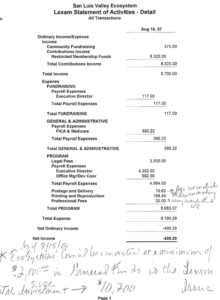
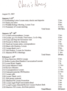
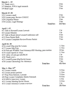
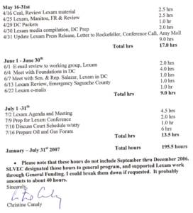
______________________________________________________________________
March 28, 2008 email:
From: Eric Karlstrom <erickarlstrom@fairpoint.net>
Date: March 28, 2008 7:09:17 AM PST
To: Charles Grant <chuckmontieth@hotmail.com>, Lisa Cyriacks <lcyriacks@rocketmail.com>, Peter May <earthdance_pdm@yahoo.com>, Kate Crestone <katecrestone@mac.com>, Jason Anderson <lrdog@hotmail.com>, Tim Brenner <timmy@ctelco.net>, Pavita Decorah <bluedeer2@yahoo.com>, Isadora <calendar@crestoneeagle.com>, Danny Ledonne <danny_ledonne@hotmail.com>, Ed Quillen <ed@cozine.com>, Lee Temple <frndsandfmly567@yahoo.com>, Don Geddes <dgeddes@centurytel.net>, insmort Hallett <insmort@bresnan.net>, Parvin Johnson <lamancha27@hotmail.com>, Kathryn Van Note <kvnnow@gmail.com>, lorainfoxdavis <rediscovery@fairpoint.net>, Donald Kropp <donkropp@sbcglobal.net>, Matie Belle Lakish <matieb42@gmail.com>, Mary Ann Sheeran <masheeran@yahoo.com>, Kim Malville <kimmalville@hotmail.com>, Vince and Mary Palermo <nulife4u2@msn.com>, Christine Canaly <slvwater@fairpoint.net>, Ceal Smith <ceal@theriver.com>, Barbara Lacey <barb.lacey@gmail.com>
Subject: concerns about agenda 21 and “sustainable growth” process
Hello neighbors,
I am increasingly concerned about the issues raised in these attached articles- and how they may pertain to our community. If you look at the diagrams in this first article: “Sustainable Trouble: The attempt to Transform the Vision of America”- we see that there is are concerted efforts on the part of the ruling elite to use the Hegelian dialectic (“thesis-antithesis-synthesis” or put another way, “problem-reaction-solution”) to bring our country under their complete tyranny. Notice that all the arrows lead to tyranny. Their immediate goal is to lock up about 50% of America’s land in the hands of the feds (this is UN-devised, and American-adopted- under Clinton- “Agenda 21”) in order to control all resources- land, water, energy, food, etc. Coincidentally(?), this also happens to be the strategic goal of all warfare. And all this is very cleverly done with facilitators with smiley faces, a game plan, and lots of subterfuge. As Sun Tzu said: “All warfare is based on deception.” Could this be happening here? Sure it could.
_____________________________________________________________________________
March 8, 2008:
Baca Residents Trying to Protect Wildlife Refuge from Gas Drilling
By Eric Karlstrom
Water Watch Alliance
I have always told people that the San Luis Valley is more than a home to me. It is a spiritual place unlike any other on earth.
Senator Ken Salazar
The San Luis Valley of southern Colorado is a unique, special place- a national treasure. Considered North America’s largest, alpine agricultural valley, the San Luis Valley is bounded on the east by the spectacular Sangre de Cristo Range and on the west by the San Juan Mountains. It contains the highest sand dunes in North America (The Great Sand Dunes National Park) as well as the adjoining Baca National Wildlife Refuge (BNWR), which protects a vast network of wetlands that are amongst the most pristine and biologically diverse in the American Southwest. The valley is underlain by one of the largest reservoirs of clean groundwater in North America, including an estimated 140 million+ acre-feet of potable water. The valley is home to significant elk, antelope and deer herds, over 45 rare, threatened or endangered species, and some of the oldest archaeological sites in North America, dating back some 11,500 years. The Pueblo, Ute, and Navajo peoples consider this valley and Mt. Blanca the most sacred places in the world. And over 20 spiritual groups, representing a variety of religious traditions, have retreat centers in the Crestone area because of the profound silence and pristine quality of nature here. And if anything unites the diverse Crestone/Baca community of about 1500, it is our shared commitment to living sustainably and preserving the natural beauty of this special place.
But storm clouds are gathering on the horizon. Lexam Explorations, Inc., a Canadian company, has applied for permits to drill three 14,000-foot gas test wells on sensitive wetlands in the new Baca National Wildlife Refuge (BNWR) just 1.5 miles west of the Baca community. Lexam, formerly Challenger Gold, owns the 75% of the mineral rights under the new (2004) Wildlife Refuge. The other 25% is owned by Conoco-Philips. Lexam is headed by Rob McEwen, former CEO and still the largest shareholder of Canada’s Goldcorp, Inc., and current CEO of U.S. Gold. As CEO of Goldcorp, McEwen oversaw the development Canada’s largest gold mine. In August, 2005, he purchased Goldcorp’s 49.8% of Lexam for $400,000 (Canadian) or 2 cents a share. Now he and his shareholders are betting that their approximately $20 million investment will yield a “tcf,” or trillion cubic feet, of natural gas, worth about $6 billion at the wellhead. Lexam’s permits are such that, if they hit gas, the exploration wells are automatically converted to production wells…. and a gas boom will begin.
When our community first learned about Lexam’s proposed drill-play in August, 2006, a group of us began educating ourselves regarding the potential impacts gas production would have on our community and the San Luis Valley. Four of us traveled to Silt, Colorado to consult with Peggy Utresch, of the Grand Valley Citizen’s Alliance. Touring the gas fields south of Silt with Peggy, we were amazed and aghast at the environmental and social devastation the gas industry has wrought upon the idyllic and pastoral communities there. Peggy brought us to the house she’d lived in before Antero built a gas drill rig in her yard in 2003. Peggy began to suffer extreme, full body skin rashes from the air pollution (ozone and B-tex chemicals, among others) emitted by the well was forced to sell this house and move to New Castle. Indeed, just standing next to her former house and breathing the contaminated air caused three of the four of us to develop symptoms of dizziness, nausea, watering of the eyes, headaches, etc. which persisted for about a week after our trip. On our 3-hour tour, we saw and photographed many features that comprise the gas production infrastructure, including gas wells, well pads, dehydrators, gas-well combustors, condensate tanks, gas pipelines, waste ponds, hydraulic fracturing fluid containers, etc. We saw big hauling trucks raising dust and creating traffic hazards along quiet country dirt roads. What were once beautiful, even idyllic rural communities now have drill rigs, well pads, etc. dispersed amongst homes, cattle, horses, and goats. Sometimes a single house is surrounded by several wells. The pads themselves are comprised simply of scraped earth and are typically about 1 acre in diameter. We saw numerous lined ponds designed to hold drilling fluids and other wastes near the pads. In addition to smelling the air pollution, we also could see the damage that ground-level ozone causes to local vegetation.
Upon returning to Crestone, we organized two community showings of the DVD film “A Land Out of Time” (www.alandoutoftime.com), a documentary that records the devastating impacts of gas exploration and drilling on communities and federal lands throughout the Rocky Mountain West. This current gas/oil boom, unprecedented in U.S. history, is due to: 1) the fast-track facilitation of fossil fuel extraction on federal lands resulting from Bush’s 2001 Executive Order 13212 (“Actions to Expedite Energy Related Projects”) and 2) Bush’s radical cutbacks of funding for the agencies charged with protecting our federal lands (the BLM, Forest Service, Park Service, and Wildlife Refuges). Peggy noted that a study showed that 90% of the changes local people wanted to see were already in the existing rules and laws- but these laws were simply not being enforced. Indeed, federal agencies typically pull people off of inspection duties and so they can concentrate on issuing more permits.
.
Our group, Water Watch Alliance (http://WaterWatchAlliance.googlepages.com) also began helping Ron Garcia, manager of the BNWR, develop “best management practices” recommendations that he could pass on to the permitting agency, the Colorado Oil and Gas Conservation Commission (COGCC). And we identified the following areas of concern: 1) maintaining the integrity and quality of our unconfined and confined aquifers, 2) damage to sensitive wetlands and wildlife, 3) maintaining integrity and access to native American sacred sites, 4) doing baseline studies of air and water quality, 5) health concerns for humans, livestock, and wildlife, 6) noise, light and dust pollution, 7) damage to local roads from heavy traffic, 8) damage to local spiritual values and communities, 9) damage to native American spiritual values, graves, and archaeological sites, 10) inadequacy of inspections, 11) control of noxious weeds.
The San Luis Basin is the northern extension of the relatively young (28 million years) Rio Grande Rift. Extensive drilling throughout the Rio Grande Rift, including the San Luis Valley, has not yet discovered commercially marketable amounts of gas and oil. However, Lexam claims that 27 of 42 shallow exploration wells drilled in 1992 and 1993 encountered “strong oil shows.” And Lexam’s geological consultants claim the seismic character of basin rocks is “remarkably similar” to that of the San Juan Basin to the west and the Raton Basin to the east, which are significant gas producers. Indeed, a map on Lexam’s website, entitled “Surrounded By Monsters!” shows the basins surrounding the San Luis Basin, including the San Juan, Raton, Denver, and Piceance Basins, have an estimated 90, 3, 6 and 23 tcf in gas reserves, respectively. Lexam is hoping that over 100 and up to 550 square miles of the Crestone sub-basin contains a 2000 to 3000 ft. thick package of Cretaceous rocks at depths of 7,000 to 17,000 feet.
The stated purpose of the BNWR, by contrast, is to restore, enhance, and maintain habitat for wildlife, plants and fish species native to the San Luis Valley. Water is a vital and irreplaceable part of this protection. We of Water Watch Alliance believe that we have raised legitimate concerns regarding the adverse impacts to water and the BNWR that have not been addressed through the NEPA process to date. We also believe that some places are best managed for other uses besides energy development and that the Baca National Wildlife Refuge is one of them.
Initially, BNWR officials told our community that they were NOT obligated to conduct a NEPA (National Environmental Policy Act) process because Lexam owns the mineral rights underneath the refuge. Subsequently, our lawyers from the Energy Minerals Law Center in Durango sued the BNWR to force the US Fish and Wildlife Service to conduct a NEPA process, as required by law. A federal judge agreed with our lawyers. So on August 7, 2007, Ron Garcia, the manager of the BNWR informed 52 of us by email that they would initiate an Environmental Assessment (EA)/scoping process at a public meeting 10 days later, August 17th. Despite the short notice, members of our community filled the meeting room and argued passionately and persuasively that the sheer scale of proposed drilling activity warrants a full Environmental Impact Statement (EIS) rather than simply the shorter, “rubber-stamp-version” Environmental Assessment. The response of BNWR representatives was to instruct us to submit our concerns in writing and that, by law, the US. Fish and Wildlife Service is obligated to address and respond to all public concerns in the EA. Indeed, NEPA was established to insure public and scientific input to determine whether or not a proposed activity on federal land would result in “significant impacts” to local physical, biological, and cultural environments. Activities associated with “significant impacts” require full-scale Environmental Impact Statements (EIS), whereas those with “no significant impacts” require the much less comprehensive Environmental Assessment (EA). Thus, in calling for an EA rather than an EIS, the BNWR was presuming there would be “no significant impacts” associated with the drilling.
On January 18, 2008, the BNWR released the Draft Environmental Assessment, written by ENSR, a private company paid by Lexam. Given this inherent conflict of interest, it is not surprising that the EA is a FONSI (“finding of no significant impact”), despite the fact that the proposed drilling activity meets all ten criteria for “significant,” as defined in NEPA. ENSR and BNWR apparently used several devices to justify their FONSI conclusion. The Draft EA: 1) does not address impacts at all, 2) assumes a priori (but never proves) “no significant impacts,” 3) ignores the NEPA definition of and overwhelming evidence for “significant impacts,” 4) completely ignores the thousands of questions and concerns which citizens submitted in writing, and 5) limits the assessment to the drilling of exploratory wells only, not acknowledging that this “precedent-setting” activity could result in significant “cumulative” impacts if gas production occurs. At the public meeting held on February 12, again despite inadequate public notification, our small community again came out in force, once again filling the room. There, I asked ENSR’s William Berg, main author of the EA and himself an oil geologist, if it would have been possible for ENSR to have concluded that there were significant impacts. His reply was “no.” Also indicative of the inherent conflict of interest at this meeting, Berg challenged our community to prove that Lexam’s drilling would contaminate the groundwater. Although it is impossible to prove future occurrences, there is an abundant record of gas drilling accidents that pollute wells, springs, ponds, etc. Regarding EnCana’s gas drilling near Silt, Colorado, for example, Peggy Utesch stated, “We know that every day there are accidents in the field – just look at the (COGC) Commission’s reports.” Indeed, gas-drilling accidents recur worldwide.
The public comment period on the Environmental Assessment is now over and we are awaiting the decision of the US Fish and Wildlife Service on whether they will let the drilling begin this summer or will call for a full Environmental Impact Statement, which would take another 18 to 24 months. Unfortunately, BNWR representatives seem to have redefined NEPA in such a way that they believe their only responsibility is to mitigate Lexam’s drilling activities. Thus, it seems that representatives of the BNWR, Lexam, and ENSR have always viewed the NEPA process as a “done deal.” If the US Fish and Wildlife Service approve the Draft EA as written, we anticipate that lawyers from the Energy Minerals Law Center will sue again and hopefully will force the BNWR to conduct an EIS, as they should have from the beginning.
Certainly, we of WWA are concerned that the many thousands of comments and concerns we have just submitted to the BNWR regarding the Draft EA will also be ignored. And we are also concerned that in this process, no official group is representing the interest of the most valuable part of the BNWR “estate”, which is the water that belongs to the people of Colorado. Finally, we feel that, in this case, the property rights of American citizens, the U.S. government (the BNWR), and the state of Colorado (the water) should supersede those of a Canadian corporation. Our group has written a letter of appeal to Governor Ritter, asking him to consider helping us protect and preserve our unique, special valley as a NO-GO (No Gas and Oil Drilling) Zone. We are asking him to place a moratorium on oil/gas drilling until base-line water studies are conducted on our aquifers to help us understand their importance to this valley and to fulfilling Colorado’s commitment to the Rio Grande Basin Compact. We also believe that the newly-formed BNWR should complete their own CCP (Comprehensive Conservation Plan) before allowing such a potentially devastating activity as gas drilling on federal land. For more information, please check our website: http://WaterWatchAlliance.googlepages.com.
_____________________________________________________________________________
March 3, 2008:
Michael Blenden 2/28/08
U.S. Fish and Wildlife Service
9383 El Rancho Lane
Alamosa, CO 81101
Email: Baca_EA@fws.gov
1) The present cabinet boasts more CEO’s than any in history. Most come from the energy, extractive and manufacturing sectors that rely on giant subsidies and create the worst pollution. Almost all the top positions at the agencies that protect our environment and oversee our resources have been filled by former lobbyists for the biggest polluters in the very businesses that these ministries oversee. These men and women seem to have entered government with the express purpose of subverting the agencies they now command.
Robert F. Kennedy, Jr., Crimes Against Nature: How George W. Bush and His Corporate Pals Are Plundering the Country and Hijacking Our Democracy (2006)
2) The U.S. government is being run like a franchise by private corporations.
Michael Ruppert
3) Laws are like cobwebs, strong enough to detain only the weak, and too weak to hold the strong.
Anarcharis, 500 B.C.
4) The 20th century has been characterized by three developments of great political importance: the growth of democracy, the growth of corporate power, and the growth of corporate propaganda as a means of protecting corporate power against democracy.
Alex Carey
5) A government should not solicit input from its citizens for the purpose of decision-making if they are simply going to ignore it.
Taos citizen at public hearing
I am attaching the bound contents of my Water Watch Alliance website (http://WaterWatchAlliance.googlepages.com) with this letter. I understand that Lexam paid ENSR nearly a million dollars to come up with their FONSI (“finding of no significant impact’) in the Draft EA submitted on January 18, 2008. By contrast, I have a staff of only one and no budget at all. Nonetheless, on this website (this volume) and in this letter, I have documented that the proposed gas drilling activity by Lexam would have many, many adverse and significant impacts to our unique and irreplaceable San Luis Valley. I invite you to consider the information and perspectives in this document, along with this letter, as my input regarding the draft EA. I suggest that the amount of truthful and useful information in this website/document probably far surpasses that included in the draft EA, which we should best regard as “corporate propaganda,” as per quote 4 above. I hope that this information I and others are supplying you might be useful for those groups or individuals charged with writing the Environmental Impact Statement that NEPA so clearly mandates in this case.
Under the present Bush administration, the oil and gas industry has commandeered our federal agencies and federal lands for its own purposes. The analogy of “the fox guarding the chicken coop” is an appropriate one. Thus, it is not surprising that the Baca National Wildlife Refuge (BNWR) has been out of compliance with the National Environmental Policy Act (NEPA) from the very beginning and remains so today. The Draft Environmental Assessment, a FONSI (“finding of no significant impact”) written by ENSR, is a cynical whitewash of a document that generally fails to address impacts and certainly fails to fulfill the requirements of NEPA. Because the impacts of the proposed drilling activity are indeed significant, adverse, cumulative, and controversial, as defined by NEPA, this draft EA fails to meet NEPA requirements. Rather, it will be necessary for the USFWS to conduct a full-scale Environmental Impact Statement in order to comply with the law.
As a resident of the Baca community, I have been involved in the public process regarding the proposed Lexam drilling since it first began in August, 2006. The experience has been frustrating, mainly because representatives of the BNWR, ENSR, and Lexam have acted in concert to subvert and undermine the NEPA process. For these individuals, the proposed drilling has always been a “done deal.” And though they are now legally bound to give the appearance of complying with NEPA, they have continually undermined and circumvented the NEPA process itself. Representatives of the BNWR have apparently even redefined NEPA so that, to them, it is simply means they need to try to mitigate Lexam’s activities. Hopefully, Federal judges will not accept the USFWS attempts to redefine NEPA. The Bush/Cheney administration program of turning the Rocky Mountain states into an “energy colony” and “national sacrifice zone” was never debated by Congress or approved by the American people. The American people reject this desecration of our land and this subversion of our democracy.
Based on the information I have compiled herein, I conclude that the relative value of the BNWR surface estate plus that of the priceless groundwater underneath the San Luis Valley far surpasses any amount of natural gas which might underlie the BNWR.
History of NEPA on the BACA
The BNWR began working to facilitate Lexam’s drilling project BEFORE initiating the NEPA process. In fact, Ron Garcia, Manager of the BNWR, initially informed our community that the BNWR was NOT legally required to comply with NEPA. The way the project was introduced to our Crestone/Baca community indicates that representatives of the BNWR had already been working with Lexam, other federal agencies (the National Park Service and the BLM), and the Sonoran Institute (a non-profit organization) to limit the scope and effectiveness of public response. This a priori collusion between government and industry suggests that the BNWR is acting on orders from senior officials in the Department of the Interior and/or the White House itself to “expedite” this drill play rather than follow the federal laws that are in place to protect public lands and public health and ensure that the American citizens have a role in the decision-making process. Unfortunately, similar attempts to circumvent NEPA are now also happening elsewhere in the U.S. due to this administration’s disregard for law (htt://pubs.acs.org/subscribe/journals/esthagw/2007/nov/policy/jp_nepa.html).
Only after the Energy Minerals Law Center lawyers sued the BNWR did the BNWR belatedly “decide” to initiate the NEPA process. How they did it, again, indicates their primary purpose was to do an end-run around NEPA. Ron Garcia, BNWR Manager, emailed 52 people from our community at 4:44 pm on August 7, 2007, notifying us that the BNWR was initiating a scoping process/Environmental Assessment at a public meeting to be held 10 days later, on Friday, August 17th, from 5:00 to 8:00 pm. His email was entitled: “Notice of Public Meeting to Discuss Resource Protection Issues Related to Gas Exploration Activities on Baca National Wildlife Refuge.” The notice did not state: “issues related to proposed gas exploration activities.” For the BNWR, it has always been and remains a “done deal,” even though NEPA law requires a fair and open process with public input and acquisition of relevant scientific data to determine if there are significant impacts associated with the proposed project.
Again, that the BNWR did NOT give customary notice of this meeting in our local newspapers and gave us only 9 days to prepare for the meeting indicates they were trying to limit our public input and response. Nonetheless, citizens from our community filled the scoping process meeting on August 17th and argued passionately and persuasively for three hours that drilling on the BNWR; 1) would degrade the surface estate and resources of the wildlife refuge and therefore is not a “reasonable or compatible use” of the refuge, 2) is not compatible with the cultural values of our community and region, and 3) would cause serious contamination of water, air, and degrade our roads and communities, as well as wildlife habitats in this still pristine and spectacular area. No one from the BNWR recorded our comments. Rather, Michael Blenden instructed us earnestly to write down our scoping comments, send them to him, and by law, the BNWR and ENSR would have to respond to each comment. Over the next 30 days, some 48,500 people sent in responses that were overwhelmingly in opposition to the drilling. This in itself indicates that the proposed action is extremely controversial and unpopular. However, based on the contents of the Draft EA, it appears that our written comments have almost entirely been ignored.
What is NEPA?
According to NEPA lawyer Travis Stills, NEPA (National Environmental Policy Act of 1969) is the “Magna Carta of environmental protection” and was written in order to address the problem of “agency capture,” i.e., situations where federal agencies and industry “forget who is who and start acting like each other.” (Clearly, the way this NEPA process has unfolded indicates that “agency capture” has occurred, despite NEPA.) NEPA is an “action forcing process” that mandates public participation and an interdisciplinary approach in the acquisition of relevant scientific data so that decisions affecting special areas and communities are not just made by industry alone. NEPA mandates that the BNWR understand and respect the “cultural values” of the San Luis Valley and our Crestone/Baca community. It also requires that cumulative, synergistic impacts be examined and that “alternatives” to satisfy the “purpose and need” of the project be considered and assessed.
NEPA mandates the disclosure of impacts, alternatives, and projected mitigation measures. One of two kinds of studies must be completed before a proposed project can go forward on federal land. An Environmental Assessment (EA) is used when there are “no significant impacts” (i.e., no unique and exceptional circumstances) associated with the proposed project. A more rigorous Environmental Impact Statement (EIS) is required when there are “significant impacts” associated with the proposed project.
NEPA specifies (http://www.nepa.gov/nepa/reg/cwq/1508.htm#1508.27) that whether or not there are “significant impacts” depends upon the context and intensity of the proposed operation. Contexts that need to be considered include society as a whole (human and national), the affected region, affected interests, and locality. Intensity pertains to the “severity of impact” regarding:
1) Impacts that may be both beneficial and adverse.
2) degree to which the proposed action affects public health and safety.
3) unique characteristics of the geographic area such as proximity to historic or cultural resources, park lands, prime farmlands, wetlands, wild and scenic rivers, or ecologically critical areas.
4) degree to which effects on the quality of the human environment are likely to be controversial.
5) degree to which the possible effects on the human environment are highly uncertain or involve unique or unknown risks.
6) degree to which the action may establish a precedent for future actions with significant effects or represents a decision in principle about a future consideration.
7) degree to which it is reasonable to expect cumulatively significant impacts on the environment.
8) degree to which the action may adversely affect districts, sites, highways, structures or objects listed in or eligible for listing in the National Register of Historic Places- or may cause loss or destruction of significant scientific, cultural, or historical resources.
9) degree to which the action may adversely impact an endangered or threatened species or its habitat- as determined under the Endangered Species Act of 1973.
10) whether an action threatens a violation of Federal, State, or local law or requirements imposed for the protection of the environment.
Note that the proposed drilling meets each of these ten criteria for “significant” in terms of context and intensity!
NEPA law also states that more than one agency may make decisions about partial aspects of a major action. Thus, Saguache County, the Baca Grande Property Owners Association, Native American Tribal Governments, Rio Grande Water Districts, the State of Colorado, grazing lease-holders on the BNWR, nearby farmers, ranchers and communities, as well as many agencies in New Mexico, Texas and Mexico, among others, also have the right and responsibility to give their input on these issues.
As we will see, even a cursory examination of the many issues related to drilling three 14,000-foot gas test wells on sensitive wetlands in the BNWR, indicates that the proposed action has very severe impacts, and thus, is highly significant in each of the above ten categories.
Despite the abundance of severe and significant impacts associated with the proposed project, the BNWR selected a private contractor, ENSR, to write an EA rather than an EIS. Note again, that EA’s are appropriate only when there is a finding of “no significant impact” (FONSI). However, industry prefers EAs because they are typically written in a relatively a short time interval and do not require the acquisition of new, baseline scientific data. In addition, the fact that Lexam itself paid ENSR to write the EA is clear conflict of interest. By contrast, a full-blown Environmental Impact Statement (EIS) is a much more thorough study requiring acquisition of new scientific data and normally takes about two years to complete. And EIS also involves the participation of the EPA (Environmental Protection Agency).
The BNWR called a public meeting on February 12, 2008, as required by NEPA, to obtain input from our community on the Draft EA. Lexam and ENSR representatives were in attendance, as well as those of the USFWS. That the issue is “controversial” is indicated by the fact that the room was packed with about 75 people and the meeting lasted 4 hours. The community unanimously argued that “significant impacts” are associated with the proposed project, and thus, a full Environmental Impact Statement must be completed. Community members demonstrated their knowledge and understanding of NEPA and the issues. We argued that 1) the context and intensity of expected impacts associated with the proposed drilling all indicate “significant impacts,” and 2) that the Draft EA does not address the many specific issues we as a community had already raised in the approximately 48,500 letters submitted during the scoping process.
ASSESSMENT OF THE DRAFT ENVIRONMENTAL ASSESSMENT: A “FONSI” (FINDING OF “NO SIGNIFICANT IMPACT”) AND CLASSIC WHITEWASH!
The BNWR released the Draft EA on January 18, 2008 (http://www.fws.gov/alamosa/BacaNWR.html). My observations about the draft EA are that Blenden and ENSR are in violation of the NEPA policy in several keys ways:
1) No impacts are addressed at all! (Recall, that NEPA mandates disclosure of impacts, alternatives and mitigation measures). If no impacts are addressed, the document becomes nothing more than a whitewash of the NEPA process.
2) In the cover letter for the document, Blenden states: “The scope of this EA does not address production of natural gas and oil from any of the wells described above.” This is another clear violation of NEPA law that:
#6 (above, under intensity of impacts) requires that NEPA examine the “degree to which the action may establish a precedent for future actions with significant effects or represents a decision in principle about a future consideration,”
#7 (above) talks about “degree to which it is reasonable to expect cumulatively significant impacts on the environment”
3) The document starts with the a priori assumption that Lexam will drill and the role of the BNWR is to help mitigate impacts. The first sentence of page 1-1 is: “The purpose of the Environmental Assessment (EA) is to ensure that initial exploration of the mineral estate under the Baca National Wildlife Refuge (Refuge) by Lexam Explorations (U.S.A.) Inc. (Lexam) is conducted in a reasonable manner.” Thus, the letter and spirit of the NEPA process are thrown out the window in the first sentence. It is not surprising then, that the rest of the document is nothing more than boiler-plate whitewash. But we know from experience that “he who pays the piper (in this case, Lexam) calls the tune (in this case the Draft EA).”
4) There is no Conclusions section at all in the document that specifically states how ENSR has arrived at the conclusion that there are “no significant impacts” or that explains how ENSR came to this conclusion. Rather, “no significant” or “minimum” impacts are simply stated and repeated throughout, without any backup by facts or data, throughout the document. Thus, regarding soils, the EA finds “minimal long-term impact,” regarding air quality: “minimum short-term impact,” regarding water; “impacts to groundwater quality less than significant” and “no impact on water use;” regarding vegetation and habitats;” less than significant impacts” and “impacts minimal,” etc.
5) For all intents and purposes, then, the EA was written for and by Lexam. The Manager of the EA project was William Berg, an oil geologist. During the public meeting of February 12, 2008, it became clear from his comments that he himself has worked in the oil/gas industry. And when I asked him directly if it would even have been possible for ENSR to have concluded that there were significant impacts and to recommend an EIS, he replied that that was not possible. Thus, it appears that indeed, “the fix is in,” the document begins with its ruling premise (no significant impacts) and then simply supports that conclusion as best it can. This is the opposite of the scientific method. Examples which indicate the built-in bias favoring Lexam’s project include:
a). On page 2-11, the EA states: “Any action by the USFWS to totally deny Lexam the reasonable opportunity to explore for minerals would likely be considered by Lexam an unconstitutional “taking” of their private property (mineral estate) without just compensation (U.S. Constitution, Amendment V). Therefore, this alternative was considered and eliminated from detailed analysis.” The EA fails to acknowledge that the application of the legal concept of a “taking” is very controversial. Over the past two decades, it has increasingly been advanced and manipulated by corporations for their own benefit, of course. However, under the Exploring Constitutional Conflicts website, we read: “The Court has had difficulty to determine when a regulation becomes a taking. There is “no set formula” and courts “must look to the particular circumstances of the case.” So on this critical issue, ENSR and the BNWR, and by extension, Lexam, have assumed that courts would rule in their favor, when in fact, they may not. Furthermore, why should the American government extend civil liberties of American citizens (in this case the 5th Amendment of the Bill of Rights) to a Canadian corporation, which is neither an American citizen nor a real person, but rather a legal fiction. Let’s be clear: Lexam is a Canadian corporation listed on the Toronto Stock Exchange. It should have no legal claim to the American Bill of Rights. If it does, surely those laws are “repugnant to the constitution” and should be declared illegal.
(“All laws which are repugnant to the Constitution are null and void” Marbury vs. Madison, 5 US (2 Cranch) 137, 174, 176 (1803). From Citizen’s Rule Book.
Specific issues ignored by the Draft EA that I raised in my scoping letter 9/5/07
Like so many others who worked hard to submit scoping comments, my comments were ignored by the BNWR and ENSR in the draft EA. I attach a copy of my 9/507 scoping letter for reference. On page 2, I mention that, by their own admission, Lexam hopes to strike on the order of a tcf (trillion cubic feet) of natural gas. Indeed, they would not want to invest about $30 million to drill three 14,000-foot test wells unless they felt there was a high probability of success. Hence, by NEPA’s own criteria, we must look at the drilling of the test wells as a “precedent setting activity” that could result in “cumulative impacts” and synergistic effects in the event of “success” and the commencement of full-scale gas production. Indeed, if gas is struck by the test wells no new permit is required to begin extracting fossil fuels. This issue is not addressed in the draft EA, but rather, is obfuscated and dodged in Michael Blenden’s cover letter when he blithely states that “the scope of this EA does not address production of natural gas and oil from any of the wells described above. If necessary, the Service regulation of production and associated transportation would be the subject of a separate analysis pursuant to the NEPA.” These statements, in the second paragraph of Blenden’s cover letter, indicate that the USFWS has failed to recognize the “precedent setting” nature of the proposed drilling or the “cumulative impacts,” and “synergistic effects” of production and transportation of natural gas on the BNWR. Thus, the USFWS is out of compliance with NEPA from the very beginning. In my graduate computer classes, we had a phrase: “garbage in, garbage out,” or GI-GO. If your assumptions are erroneous, you conclusions will be erroneous as well.
On page 7, I asked the question whether this drill-play may have something to do with a government-corporate strategy that might relate to Vice President Cheney’s Energy Task Force. Is this why they are trying to get into “the best places first” as former National Forest Supervisor Gloria Flora observed. Could this proposed activity have anything to do with U.N. Agenda 21? And although this issue was not addressed in the Draft EA, I would like to pose an additional question: Might this project relate to a relatively secret mega-project by U.S. Federal Agencies to build “Energy Corridors on Federal Lands in the 11 Western States?” A pending EIS on this project describes that the lead agencies for this proposed project are the US Department of Energy, U.S. Department of the Interior, BLM, US Forest Service, U.S. Department of Defense, U.S. Fish and Wildlife Service, the State of Wyoming and 10 other agencies. Might this gas play then relate to a future energy corridor being planned for the area along the present Highway 50 in Colorado? If so, why all the secrecy?
In my scoping letter, I identified 15 areas of concern and adverse impacts. I don’t space or energy to do a point-by-point analysis. However, examination of just a few of the critical areas will reveal that these many of these impacts are significant based on NEPA definitions.
I) Impacts on groundwater and water quality
In my scoping letter of 9/507, I detail many ways in which the proposed drilling and related activities could and would contaminate surface and groundwater. These include:
a) the sensitive nature of the aquifers
b) near-term impacts of aquifer pollution on humans, in terms of drinking water and irrigation
c) contamination of aquifer wells already in existence.
d) long-term contamination of aquifers by gas drilling, hydraulic fracturing, evaporation ponds, leaks, spills, accidents, additions of produced water at the surface, etc. (page 2)
e) potential impacts of water contamination on downstream users (page 1) based on Rio Grande Compact.
f) specific chemical pollutants/contaminants, methane, fracturing fluids, B-tex (benzene, toluene, ethyl benzene, zylene), diesel feul, hydrogen sulfide, heavy metals, VOCs, formaldehyde and PAH’s (Colborn, 1997). Propolene glycol used on well pads is fatal for animals.
g) deterioration of concrete casings over time will cause future pollution of aquifer
h) and why should local county officials accept that each gas well is automatically exempt from following the safety standards for clean water outlined in the Clean Water Act and Safe Drinking Water Act?
Note that each of the above factors and all of them taken cumulatively would have significant impacts as defined by NEPA criteria, including:
#2 – affects public health and safety,
#3 – affects parklands, farmlands, wetlands, ecologically critical areas,
#4 – affects on quality of human environment are controversial,
#5 – highly uncertain, unique, unknown risks,
#6- sets a precedent for future action,
#7) cumulative impacts,
#9) action may threaten endangered or threatened species.
#10) threatens violation of federal, state or local law.
Interestingly, during the public meeting on the draft EA, William Berg, main author of the draft EA and himself an oil geologist, challenged me to prove that gas drilling on the Baca Refuge would contaminate the aquifer. Of course, no one can prove a future occurrence. However, the sheer number of accidents that have occurred in the gas fields of Colorado resulting in pollution of wells, ponds, and aquifers, explosion of buildings, etc. is proof that this kind of activity frequently pollutes groundwater. As Peggy Utesch of the Grand Valley Citizen’s Alliance stated regarding EnCana’s drilling activities near Silt, Colorado: “We know there are accidents every day. All you have to do is look at the (COGC) Commissions’ reports.” I document many accidents associated with gas drilling activity on my website: http://WaterWatchAlliance.googlepages.com. Please go to the page on Accidents in the Gas Fields.
These kinds of impacts, by and large, are not addressed at all in the Draft EA. Therefore, a full EIS is required. To the concerns I raised in my scoping letter, I would now add the following concerns:
The Regulations Fall Short!
Americans get over half of their clean drinking water from underground sources. In 2005, the oil and gas industry was granted an exemption from the Safe Drinking Water Act, making the oil and gas the only industry allowed to inject toxic fluids directly into good quality groundwater without oversight by the Environmental Protection Agency (EPA). At the state level, most oil and gas regulatory agencies do not require companies to report the volumes or names of the chemicals being injected during hydraulic fracturing. Thus, neither the government nor the public can evaluate the risks posed by injecting these fluids underground. (www.earthworksaction.org/pubs/Fracking.pdf)
San Luis Valley Water: A Fragile Abundance
A 1974 geological report estimates that aquifers in the San Luis Valley hold 2 billion acre feet of water, of which at least 140 million acre-feet is potable. At the (2001) going rate of $5,000 to $12,000 per acre-foot, the value of this water is over $700 billion to $1.7 trillion. In other words: It is priceless!
Thousands of wells in the unconfined and confined aquifers supply irrigation and drinking water for the San Luis Valley. These aquifers are “highly sensitive” and vulnerable to infiltrating contamination because: 1) Depth to water table is shallow, averaging only about 7 feet, 2) Surface soils are typically sandy and highly porous, 3) aquifers are comprised mostly of porous unconsolidated sands and gravels, and 4) faults and fractures are common and hence, the aquifers recharge rapidly and water pollutants can move through the aquifers and mix readily.
How Oil and Gas Operations Can Contaminate Groundwater
In gas drilling, serious pollution can come from both the surface (from evaporation ponds, drilling pits, condensate, leachate, spills, etc.) and from the subsurface (by mixing of water with toxic drilling fluids, cuttings, and oil and gas). Drilling fluids used in the “hydraulic fracturing” process, used in 90% of gas wells, are exempt from regulation by the Clean Water Act. Each “frack” or “shot” requires a million gallons and causes mini-earthquakes at depth. “Fracking” fluids include a toxic suite of chemicals, including B-Tex (benzene, toluene, ethyl benzene and xylene), heavy metals, diesel fuel, VOC’s (volatile organic compounds), formaldehyde, methane, and hydrogen sulfide. Of the 245 chemicals used, 91% have adverse health effects and 35% have endocrine disrupting effects (www.endocrinedisruption.org). Through evaporation and leaching, these chemicals also contaminate air and soils.
If coal beds are found, the mining of coal-bed methane (CBM) gas is even more toxic. Then, drillers 1) pump enormous quantities of briny “produced water” to the surface, and 2) enlarge the borehole by injecting high-pressure gas into the well. Gas and oil themselves evaporate easily, dissolve in water, and are toxic. One component, benzene, is carcinogenic. Because hydrocarbons are less dense than water, they rapidly move upward through aquifers. Hence, gas and oil can leak upward from the confined aquifer into the unconfined (surface) aquifer. One quart of oil can contaminate 250,000 gallons of water! And concentrations of methane gas above 10 mg/l are ignitable. Well water from the confined aquifer between Alamosa and Moffat already has ignitable levels of methane. A new house east of Mosca exploded in 2003! Finally, concrete well casings typically deteriorate after 20 years, so old wells can also be a major source of pollution.
For more information, check http://WaterWatchAlliance.googlepages.com.
II) Potential Impacts from Hydraulic Fracturing and Mining of Coal Bed Methane (CBM) Gas
To consider the even more profound and adverse impacts associated with hydraulic fracturing and mining of coalbed methane gas, please refer to the appropriate sections of my website (appended volume).
III) Air pollution
Gas wells cause photochemical smog. Photochemical smog is formed where volatile organic compounds and nitrogen oxides mix in the presence of sunlight. Although often termed “haze” when associated with gas wells, the chemicals and the effects are identical to that of smog in our large western cities and include a loss of visibility and formation of secondary pollutants such as ground level ozone and sulfur trioxide. Today, the clear atmospheric conditions in the San Luis Valley are some of the best for solar electrical generation in the entire U.S. Obviously, formation of haze (smog) here will “significantly” reduce this areas potential to lead the nation in generation of clean electrical energy from the sun.
In addition, other toxic carcinogenic compounds emitted from drill pads, include ground level ozone (with damaging health effects for humans, animals, plants and crops), B-tex, PM-10, as well as pollution from evaporation ponds, dust from trucks and roads, toxic leaks from pipelines. Ozone is the single greatest cause of asthma.
Flaring of gas from wells emits great quantities of VOCs and nitrogen oxides. Gas operations south of Silt Colorado have caused illness amongst local residents and die-off of goat herds.
I could continue to point out the egregious inadequacies of the Draft EA in terms of each of the categories of impacts I outlined before, including health concerns, impacts on wildlife, noise, light and dust pollution, damage to roads by heavy vehicles, infrastructure requirements, etc. But I imagine other concerned individuals will address these topics adequately. I can only hope that the USFWS and will be compelled to follow NEPA more carefully in the future.
The San Luis Valley is unique and irreplaceable national treasure. We are seeing here a battle between the mineral estate and the surface estate. Not represented at the table is the value of the most valuable estate of all, the water, which is owned by the people of Colorado. Although it is impossible to place a value on the wealth of the surface estate and the water, they are certainly worth infinitely more than the minerals under the BNWR.
Sincerely,
Dr. Eric Karlstrom, Professor of Geography, Coordinator, Water Watch Alliance
P.O. Box 54, Crestone, CO 81131; Email: erickarlstrom@fairpoint.net
CC:
Governor Bill Ritter: 136 State Capitol, Denver, CO 80203-1729. Phone: 800-283-7215 or 303-866-2471, fax- 303-866-2003, Email: www.Colorado.gov
Senator Ken Salazar: 702 Hart Senate Office Building, Washington, D.C. 20519
Washington, D.C.- phone- 202-224-5852, fax 202-228-5036. Alamosa office: 609 Main St. #110, Alamosa, CO 81101; email: charlotte_bobicki@salazar.senate.gov, phone: 719-587-0096, fax: 719-587-5137, Denver office: toll free phone 866-455-9866, phone 303-455-7600, fax- 303- 455-8851, Email: salazar.senate.gov/contact/email.cfm
Senator Wayne Allard: 525 Dirksen Senate Office Building, Washington, D.C., 20519
Washington, D.C.: phone- 202-224-5941, fax- 202-224-6471. Denver office: phone- 303-220-7414, fax- 303-220-8126. Email: allard.senate.gov/
U.S. Representative John Salazar: 1531 Longworth House Office Building, Washington, D.C. 20515 Washington, D.C.- 202-225-4761, fax- 202-226-9669. Alamosa office: 609 Main Street, Alamosa, CO 81101; Email: erin.minks@mail.house.gov. phone- 719-587-5105, fax- 719-587-5137. Email: house.gov/salazar/contact.shtml
State Senator Gail Schwartz- 200 E. Colfax, Denver, CO 80203, Capitol phone: 303-866-4871
Email: gail.schwartz.senate@state.co.us
State Representative Tom Massey (R- Dist. 60) 200 E. Colfax, Denver, CO 80203, Capitol phone: 303-866-2747, 303-866-2346, Email: tom.massey.house@state.co.us
Saguache County Commissioners: P.O. Box 655, Saguache, CO 81149 1) Linda Joseph: phone- 719-256-5003, Email: sagcomlj@centurytel.net 2). Sam Pace- 719-256-4660 3) Michael J. Spearman-719-754-2486
Colorado Department of Wildlife: Wendy Wallis, Phone: 303-291-7208
Email: wendy.wallis@state.co.us
David Neslin, COGCC, 1120 Lincoln Street, Suite 801, Denver, CO 80203 (303-894-2400)
David B. Martin, Colorado Department of Public Health and Environment, 4300 Cherry Creek Drive South, Denver, CO 80246-1530, (800-886-7689)
Jay Slack, USFWS, 134 Union Ave., Lakewood, CO 80228
Robbie Roberts, U.S. EPA Region 8, 1595 Wynkoop St., Denver,CO 80202-1129
__________________________________________________________________________
February 23, 2008:
PRESS RELEASE from Water Watch Alliance, Crestone, Colorado 2/23/08
The well-being of Colorado water and Colorado citizens is now threatened to an unprecedented degree by toxic pollutants, potential “blow-outs,” and mismanagement by government agencies. While residents in Leadville are fighting for their safety and the life of the Arkansas River, residents in the San Luis Valley are fighting to protect and preserve one of the largest fresh water aquifers in North America. This irreplaceable treasure, containing an estimated 140+ million acre-feet (or 45+ trillion gallons) of potable water, is threatened by the proposed drilling of three 14,000-foot gas test wells on the new Baca National Wildlife Refuge (BNWR) by Lexam Explorations, Inc., a Canadian company.
The San Luis Valley of southern Colorado is considered a sacred place by the Pueblo, Ute and Navajo Indians and by internationally-acclaimed Tibetan spiritual leaders. Senator Ken Salazar states: “I have always told people that the San Luis Valley is more than a home to me. It is a spiritual place unlike any other on earth.”
Rather than protecting the Wildlife Refuge, however, The U.S. Fish and Wildlife Service (USFWS) actually attempted to circumvent the NEPA (National Environmental Policy Act) process until they were ordered by a federal judge to comply with NEPA. Lexam then hired the private firm, ENSR, to complete an Environmental Assessment (EA). Not surprisingly, the Draft EA, released on January 18, is a “FONSI” or “Finding of No Significant Impact.” If USFWS approves the Draft EA without recommending an Environmental Impact Statement (EIS), Lexam could begin drilling this summer.
Local citizens are challenging the Draft EA and demanding that a full EIS be commissioned by a neutral source. They are also asking Colorado Governor Bill Ritter to impose a moratorium on the drilling in the San Luis Valley until potential impacts to the Refuge and to the aquifer can be fairly evaluated. The Fish and Wildlife Service is accepting public input on the Draft EA until March 2. More information is on this website: http://WaterWatchAlliance.googlepages.com
Interested parties are encouraged to write, call and/or email the following:
Michael Blenden, USFWS, 9383 El Rancho Lane, Alamosa, CO 81131, (719-589-4021), Baca_EA@fws.gov
Governor Bill Ritter: 136 State Capitol, Denver, CO 80203-1792 (303-866-2471)
Senator Ken Salazar: 609 Main Street, #110, Alamosa, CO 81101 (719-587-0096)
Senator Wayne Allard: 411 Thatcher Building, Pueblo, CO 81003 (719-545-9751)
Representative John Salazar: 609 Main Street, #6, Alamosa, CO 81101 (719-587-5105)
Senator Gail Schwartz: 200 E. Colfax, Denver, CO 80203 (303-866-4871)
David Neslin, COGCC, 1120 Lincoln Street, Suite 801, Denver, CO 80203 (303-894-2400)
David B. Martin, Colorado Department of Public Health and Environment, 4300 Cherry Creek Drive South, Denver, CO 80246-1530, (800-886-7689)
Saguache County Commissioners, P.O. Box 655, Saguache, CO 81149
Jay Slack, USFWS, 134 Union Ave., Lakewood, CO 80228
Robbie Roberts, U.S. EPA Region 8, 1595 Wynkoop St., Denver, CO 80202-1129
_____________________________________________________________________________
February 19, 2008:
Open letter to Governor Bill Ritter 2/19/08
I have always told people that the San Luis Valley is more than a home to me. It is a spiritual place unlike any other on earth.
Senator Ken Salazar
We in the San Luis Valley of southern Colorado live in a unique and spectacular place; indeed, this valley is a priceless, national treasure. Considered North America’s largest, alpine agricultural valley, the San Luis Valley is surrounded by the spectacular Sangre de Cristo Range on the east and the San Juan Mountains to the west. It contains the highest sand dunes in North America (The Great Sand Dunes National Park) and the adjoining Baca National Wildlife Refuge (BNWR), which protects a vast network of wetlands that are amongst the most pristine and biologically diverse in the American Southwest. Significant elk, antelope and deer herds, over 45 rare, threatened or endangered species, and some of the oldest archaeological sites in North America, dating back some 11,500 years, are here. The Pueblo, Ute, and Navajo peoples consider this valley and Mt. Blanca the most sacred places in the world. Over 20 spiritual groups, representing a variety of religious traditions, have retreat centers here because of the profound silence and pristine quality of nature. But perhaps most important for future generations, this valley is underlain by one of the largest reservoirs of clean groundwater in North America, including an estimated 140 million+ acre-feet of potable water (Pearl, 1974).
In August, 2006, Lexam Explorations, Inc., a Canadian company, applied for permits to drill two 14,000-foot exploratory gas test wells on sensitive wetlands in the BNWR about 1.5 miles west of our community. Initially, BNWR officials told us they were NOT obligated to conduct a NEPA (National Environmental Policy Act) process because Lexam owns the mineral rights underneath the refuge. However, after our lawyers sued, a federal judge instructed the BNWR that they are legally bound to conduct a NEPA process. So on August 17, 2007, the BNWR initiated an Environmental Assessment (EA)/scoping process at a public meeting where they instructed us to submit our concerns in writing and informed us that, by law, they were obligated to address and respond to our concerns in the EA. As you know, Governor Ritter, NEPA was established to insure public and scientific input to determine whether or not a proposed activity on federal land would result in “significant impacts” to local physical, biological, and cultural environments. Whereas activities with “significant impacts” require full-scale Environmental Impact Statements (EIS), those with “no significant impacts” require the much less comprehensive Environmental Assessment (EA).
On January 18, 2008, the BNWR released the Draft EA, written by ENSR, a private contracting company paid by Lexam. Given this inherent conflict of interest, it is not surprising that the EA is a FONSI (“finding of no significant impact) even though the proposed drilling activity meets all ten criteria for “significant” defined in NEPA. ENSR and BNWR apparently used several devices to justify their FONSI conclusion. The Draft EA: 1) assumes a priori (but never proves) “no significant impacts,” 2) ignores the NEPA definition of and overwhelming evidence for “significant impacts,” 3) ignores the substantial number of questions and concerns which citizens submitted in writing, 4) does not address impacts at all, and 5) limits the assessment to the drilling of exploratory wells, not acknowledging that this “precedent-setting” activity could result in significant “cumulative” impacts if gas production occurs. Indicative of the conflict of interest here, at the public meeting, William Berg, oil geologist and main author of the Draft EA, challenged our community to prove that drilling would contaminate groundwater. Although it is impossible to prove future occurrences, there is an abundant record of gas drilling accidents that have polluted wells, springs, ponds, etc. Regarding EnCana’s gas drilling near Silt, Colorado, for example, Peggy Utesch (Grand Valley Citizen’s Alliance) stated, “We know that every day there are accidents in the field – just look at the (COGC) Commission’s reports.” Indeed, gas-drilling accidents recur worldwide.
The purpose of the BNWR is to restore, enhance, and maintain habitat for wildlife, plants and fish species native to the San Luis Valley. Water is a vital and irreplaceable part of this protection. We believe that we have raised legitimate concerns regarding the adverse impacts to water and the BNWR that have not been addressed through the NEPA process to date. We also believe that some places are best managed for other uses besides energy development and the Baca National Wildlife Refuge is one of them.
BNWR representatives have apparently now redefined NEPA in such a way that their only responsibility is to mitigate Lexam’s drilling activities. Thus, it seems that representatives of the BNWR, Lexam, and ENSR view the NEPA process as a “done deal.” Whereas we are participating in the NEPA process in good faith, we question whether the USFWS is following the NEPA process honestly and fairly. They did not respond to the many concerns we submitted during the EA/scoping process, as they promised they would. So we are concerned that the comments and concerns we are now submitting to the BNWR during the present public comment period will be ignored, just as they were before. And we are also concerned that in this process, no official group is representing the interest of the most valuable part of the BNWR “estate”, which is the water that belongs to the people of Colorado. Finally, we feel that, in this case at least, the property rights of American citizens, the U.S. government (the BNWR), and the state of Colorado (the water) should supersede those of a Canadian corporation. For more information, please check our website: http://WaterWatchAlliance.googlepages.com.
Although we know you have many diverse interests to balance, we ask you, Governor Ritter, to please consider helping us protect and preserve this unique, special valley as a NO-GO (No Gas and Oil Drilling) Zone. We urge you to place a moratorium on oil/gas drilling until base-line water studies are conducted on our aquifers to help us understand their importance to this valley and to fulfilling Colorado’s commitment to the Rio Grande Basin Compact.
Respectfully yours,
Dr. Eric Karlstrom, Lisa Cyriaks, Chuck Grant, Parvin Johnson, Tom Ontko, Susan N. Vaughan, Dr. Phil Schecter, (Water Watch Alliance)
Cc: Senators Ken Salazar and Wayne Allard, Representative John Salazar, Senator Gail Schwarz, David Neslin (COGCC), Jay Slack (U.S. F&WS), Jim Martin (Colorado Dept. of Public Health), Harris Sherman (Colorado Dept. of Natural Resources), Representatives Tom and Mark Udall, Governor Bill Richardson, Senators Barack Obama and Hillary Clinton, media
_______________________________________________________________________________
Flier; Feb. 12, 2008:
WATER AND GAS DON’T MIX IN THE SAN LUIS VALLEY!
The Regulations Fall Short!
Americans get over half of their clean drinking water from underground sources. In 2005, the oil and gas industry was granted an exemption from the Safe Drinking Water Act, making the oil and gas the only industry allowed to inject toxic fluids directly into good quality groundwater without oversight by the Environmental Protection Agency (EPA). At the state level, most oil and gas regulatory agencies do not require companies to report the volumes or names of the chemicals being injected during hydraulic fracturing. Thus, neither the government nor the public can evaluate the risks posed by injecting these fluids underground. (www.earthworksaction.org/pubs/Fracking.pdf)
San Luis Valley Water: A Fragile Abundance
A 1974 geological report estimates that aquifers in the San Luis Valley hold 2 billion acre feet of water, of which at least 140 million acre feet is potable. At the (2001) going rate of $5000 per acre-foot, the value of this water is over $700 billion. Or at the price of bottled water, over $8.5 trillion. I.e., it is priceless!
Thousands of wells in the unconfined and confined aquifers supply irrigation and drinking water for the San Luis Valley. These aquifers are “highly sensitive” and vulnerable to infiltrating contamination because: 1) Depth to water table is shallow, averaging only about 7 feet, 2) Surface soils are typically sandy and highly porous, 3) aquifers are comprised mostly of porous unconsolidated sands and gravels, and 4) faults and fractures are common and hence, the aquifers recharge rapidly and water pollutants can move through the aquifers and mix readily.
How Oil and Gas Operations Can Contaminate Groundwater
In gas drilling, serious pollution can come from both the surface (from evaporation ponds, drilling pits, condensate, leachate, spills, etc.) and from the subsurface (by mixing of water with toxic drilling fluids, cuttings, and oil and gas). Drilling fluids used in the “hydraulic fracturing” process, used in 90% of gas wells, are exempt from regulation by the Clean Water Act. Each “frack” or “shot” requires a million gallons and causes mini-earthquakes at depth. “Fracking” fluids include a toxic suite of chemicals, including B-Tex (benzene, toluene, ethylbenzene and xylene), heavy metals, diesel fuel, VOC’s (volatile organic compounds), formaldehyde, methane, and hydrogen sulfide. Of the 245 chemicals used, 91% have adverse health effects and 35% have endocrine disrupting effects (www.endocrinedisruption.org). Through evaporation and leaching, these chemicals also contaminate air and soils.
If coal beds are found, the mining of coal-bed methane (CBM) gas is even more toxic. Then, drillers 1) pump enormous quantities of briny “produced water” to the surface, and 2) enlarge the borehole by injecting high pressure gas into the well. Gas and oil themselves evaporate easily, dissolve in water, and are toxic. One component, benzene, is carcinogenic. Because hydrocarbons are less dense than water, they rapidly move upward through aquifers. Hence, gas and oil can leak upward from the confined aquifer into the unconfined (surface) aquifer. One quart of oil can contaminate 250,000 gallons of water! And concentrations of methane gas above 10 mg/l are ignitable. Well water from the confined aquifer between Alamosa and Moffat already has ignitable levels of methane. A new house east of Mosca exploded in 2003! Finally, concrete well casings typically deteriorate after 20 years, so old wells can also be a major source of pollution.
For more information, check http://WaterWatchAlliance.googlepages.com.
______________________________________________________________________________
Flier (back side): January 23, 2008:
URGENT!
IMAGINE THE WATER, AIR, NOISE, LIGHT, AND DUST POLLUTION OF
1,000’S OF GAS WELLS ON THE BACA NATIONAL WILDLIFE REFUGE.
YOUR HELP IS NEEDED NOW!!!
Time is running out if we hope to stop oil and gas exploration in the San Luis Valley! Recent information suggests that early reports of “little chance” of finding natural gas are not true: Rather, it is a “virtual certainty,” and major gas production by ConocoPhillips (the company now drilling in Arctic N. Wildlife R.) will begin after test wells strike hydrocarbons. Lexam Explorations, Inc. hopes to start drilling in the summer of 2008. If drilling begins it may be impossible to stop this Valley from becoming an industrial park. We only have a short time to communicate with officials concerning the insanity of allowing drilling and related activities in the vicinity of one of the largest and most important aquifers in the U.S. People can live without natural gas, but not without clean water. The risks of contamination are too great for ourselves and future generations. Please write or call the individuals below. To help cover financial costs related to copying, postage, etc., please consider donating money to Water Watch Alliance, P.O. Box 653, Crestone, CO, 81131. The communities, ranchers, and ecosystems of the San Luis Valley thank you!
Governor Bill Ritter: 136 State Capitol, Denver, CO 80203-1729; 800-283-7215 or 303-866-2471, fax- 303-866-2003; Email: www.Colorado.gov
Senator Ken Salazar: 702 Hart Senate Office Building, Washington, D.C. 20515; (202)- 224-5852; Alamosa: (719)-587-0096, (866)-455-9866, Denver: 303-455-7600; email: salazar.senate.gov/contact/email.cfm
Senator Wayne Allard: 525 Dirksen Senate Office Building, Washington, D.C., 20515; 202-224-5941, Denver: phone- 303-220-7414; email: allard.senate.gov/
U.S. Representative John Salazar: 1531 Longworth House Office Building, Washington, D.C. 20515;
202-225-4761; 609 Main Street, Alamosa, CO 81101; phone- 719-587-5105, email: house.gov/salazar/contact.shtml
State Senator Gail Schartz: 200 E. Colfax, Denver, CO 80203; 303-866-4871; email: gail.schwartz.senate@state.co.us
State Representative Tom Massey (R- Dist. 60): 200 E. Colfax, Denver, CO 80203; 303-866-2747, 303-866-2346; email: tom.massey.house@state.co.us
Saguache County Commissioners: Linda Joseph, Sam Pace, Michael J. Spearman; Saguache County, P.O. Box 655; 719-655-2231; email: sagcomlj@centurytel.net
This could be one of the most important public services that you can render in your lifetime. It is important that you do it now!!!
______________________________________________________________________________
January 2, 2008:
Dear County Commissioners:
For the following reasons, I believe a 6 month moratorium is required as an absolute minimum for the purpose of fact finding by county officials:
1) On it’s own website to encourage investors, Lexam points out the SLV is “surrounded by monsters” with the San Juan Basin having produced 90 tcf and the Raton Basin having produced 3 tcf of natural gas. And on their website, Lexam shows a cross-section of geologic target formations- the Lower Cretaceous Mancos Shale (source rock) and the Lower Cretaceous Dakota Sandstone (reservoir rock). What they do not discuss, is the fact that huge proportions of the natural gas recovered from the SJB and RB are from coal-bed methane (CBM) gas. In the San Juan Basin, the CBM resource is estimated at 50 tcf from the Fruitland Formation and another 34 tcf from the Menefee Formation. Both of these are Upper Cretaceous sedimentary rocks that overlie the Dakota and Morrison Formations. (Currently, about 65% of the total production of the San Juan Basin is from the Fruitland coal formation. In the Raton Basin, CBM gas comes from the coal beds in the Vermejo and Raton Formations, which are also Upper Cretaceous rocks that overlie the Dakota and Morrison Formations. Interestingly, CBM gas from the Fruitland Formation in the San Juan Basin which began in 1951 was never referred to as CBM gas.
2) Additional problems of Coal-Bed-Methane Gas:
a) since the gas is stored in cracks and micropores in the coal deposits, water must be pumped out of the ground (“produced”) before the gas can be extracted. In 1998 alone, (the last year for which statistics were available), over 597 million gallons of water was pumped from the Las Animas County methane wells in the Raton Basin. Not surprisingly, Hemborg (1998) showed that in the Raton Basin, in most cases water yield from wells decreased dramatically as CBM production increased over time. Meanwhile, “produced water” itself is often extremely saline and sodic- and if it is concentrated at the surface it can ruin existing soils and sediments at the surface, rendering them unsuitable for agricultural purposes indefinitely.
b) Two main methods used to produce CBM wells include the “cavitation method” and hydraulic fracturing. The cavitation method creates a cavity in the targeted coal seams by altering the velocity of gas escaping from the coal reservoir. This effectively enlarges the original well bore and increases the chances of contaminating aquifer water with hydrocarbons. Hydraulic fracturing involves pumping fracture fluids under high pressure through pipe perforations in the coal bed. These fracturing fluids have been found to include many carcinogenic agents which contaminate ground water.
c) Thus, the BLM has adopted COGCC order No. 112-61, which requires that the production casing of all coal-bed methane wells be cemented from producing horizon to the surface by grout circulation methods. This is done to minimize the inter-zonal flow of fluids between the producing horizons and aquifers.
As a trained physical geographer with over 30 years of teaching and research experience, I would like to offer my services to the County Commissioners and the POA board to help educate them in these matters. I have been studying the issues related to the proposed Lexam drilling since August of 2006 and accumulated a considerable amount of information. Perhaps we could have one or two lecture/seminars on this topic specifically for these elected officials.
Sincerely,
Professor Eric T. Karlstrom, Ph.D.
Physical and Environmental Geography
Water Watch Alliance
_________________________________________________________________________
Rob McEwen (CEO of Lexam, Inc.) Quotes
From Sun Tzu
Hence, when able to attack, we must seem unable;
when using our forces, we must seem inactive,
when we are near, we must make the enemy believe we are far away;
when far away, we must make him believe we are near.
If your opponent is of choleric temper, seek to irritate him.
If he is taking his ease, give him no rest.
If his forces are united, separate him.
Attack him where he is unprepared, appear where you are not expected.
Speed is the essence of war
Take advantage of the enemy’s unpreparedness; travel by unexpected routes and strike where he has no precautions.
Not listed but implied (All warfare is based on deception).
Sun Tzu
The way to make money is to buy when blood is running in the streets
John D. Rockefeller
Veni, vidi, vici (I came, I saw, I conquered)
Julius Ceasar
_________________________________________________________________________
November 22, 2007:
Comments on the threats of: 1) proposed Lexam gas drilling, and 2) NAT request to close trailheads in the Baca Grande:
Dear POA Board and County Commissioners,
Introduction
People may legitimately have different perspectives and opinions on controversial issues. As a geography professor, I try to see the connections between things, particularly regarding human/earth interactions. My perspective is informed by my many years of university research and teaching about environmental/energy issues. I believe local issues and events are often best understood by placing these in the context of larger national and international economic and political forces. Today, even our quiet and relatively unspoiled San Luis Valley is being affected by these larger forces. Thus, it is imperative that we have a realistic understanding of what “globalization”really is, how it works, who benefits, and who pays. The principles of “globalization” (also sometimes called: “The New World Order”) are well defined in numerous international treaties/organizations like NAFTA (North American Free Trade Agreement), FTAA (Free Trade Agreement of the Americas) and WTO (World Trade Organization); the planned North American Union (NAU); and in countless United Nations policies and resolutions. These “internationalist” institutions and treaties advance and enforce the principle that corporate and private-property rights supercede the sovereignty of nations the rights of citizens. Ultimately, they require the dismantling of the United States of America and the U.S. Constitution. Because I believe it is imperative that local, democratically-elected officials educate themselves on these issues, I attaching my lecture notes on the topic of eco-politics and eco-nomics (from my Human Ecology course at California State University).
The extensive bibliography at the end of these notes give many sources that corroborate my interpretations regarding the immediate issues facing our community. I am also attaching various pertinent articles, videos. An even broader perspective can be gleaned by listening to an interview I did with Canadian Alan Watt on KHEN’s “Truth Quest” on October 30, 2007. I include a link to this interview: The last third of the first hour deals specifically with the issues of Lexam, oil and gas development, and the United Nations Agenda 21, all of which directly affect us and our San Luis Valley. This web link and my lecture notes are attached at the end of this message.
Comments
Amongst the many things we have to be grateful for in the Crestone/Baca area on this Thanksgiving Day are our: 1) ready access to U.S. public lands offering some of the most beautiful and pristine mountain/desert environments in the world, 2) vast expanses of uncrowded spaces, and 3) clean and pure air and water, and 4) profound silence, an asset essential for the many local spiritual groups. Unfortunately, these priceless assets appear now to be under threat- not from Moslem extremists or global warming- two politically correct “public enemies” promoted by our ruling elite and media. Rather, it seems to me they are threatened by two Canadian billionaires; Lexam’s CEO Rob McEwen, and former owner of the Baca Ranch and United Nations magnate, Maurice Strong. McEwen (and Lexam Exporations, Inc.) has immediate plans to pollute our air and water and destroy the silence and pristine majesty of our Valley in order to reap millions and perhaps billions in windfall profits for himself, his shareholders, and his business partners. And Strong, through his Danish wife Hanne’s Manitou Foundation, apparently wishes to cut off American’s access to our own public lands. Could this and the great increase in public lands designation in our Valley relate to the U.N.’s Agenda 21?
Why do I link these two individuals and their possible agendas? Let’s review the facts. Most recently, we should be aware that both the issues of Lexam proposed drilling and the potential trailhead closures in the Baca were first made known to our Crestone/Baca community through the Sonoran Institute, a non-profit environmental group. Thus, initial community responses to these issues were influenced by the (un-elected) individuals who volunteered to make recommendations regarding these issues. Second, recall that Maurice Strong acquired the Baca Ranch back the late 70’s, at which time he severed the mineral rights from the surface estate. In the 80’s his AWDI (American Water Development ) tried unsuccessfully to make billions by exporting groundwater from under the Ranch to the Front Range.
Although most locals view Maurice and Hanne Strong as generous benefactors who donated land to various spiritual groups, we would be well to look deeper into Maurice’s past activities. If we do so, we see that he is a major player in the “globalist-New World Order” agenda.
Although his bio is much too long for me to reproduce here, he is notable for the fact that in addition to being CEO of many major Canadian energy and water corporations (including Power Corporation, Petro-Canada, Hydro Canada, Ontario Hydro (North America’s Largest utility company), Alberta Gas Company, and Dome Petroleum), he has also been perhaps the single most powerful unelected bureaucrat in the United Nations. In this capacity, he organized and directed the Earth Summit I in Stockholm in 1972, Earth Summit II in Rio de Janeiro in 1992, and the United Nations Environmental Programme (UNEP). With former Soviet President Mikhail Gorbachev, Strong authored the U.N. Earth Charter. He also served on the U.N.’s World Commission on Environment and Development and Commission on Global Governance. (I attach a letter I wrote recently to the Colorado Oil Gas Conservation Commission, which gives a more detailed history of Strong’s involvement with the Baca, the U.N. and water and power corporations.)
Strong was also authored the U.N.’s Agenda 21, adopted by the U.S. under President Clinton in the 1990’s. Agenda 21 calls for putting away over 50% of the America land. Although Agenda 21 is justified in the name of protecting nature, many people believe that it has an altogether different objective. Daniel Beckett states: The real agenda behind “Sustainable Development” has nothing to do with protecting the environment. It is about controlling natural resources. If the resources are controlled, the people are controlled.” (I attach a couple articles on Agenda 21 here).
Ironically, these Canadian billionaires and their surrogates are now justifying their claims on our land and resources on the basis of their “private property” rights. (Thus, the property rights of rich foreigners now apparently supercedes the rights of the U.S. government itself as well the American citizens who actually live in this area). Am I dreaming, or have we returned full-circle to a new “Age of Robber Barons,” with the modern twist that today’s super-rich are an international elite with little or no national allegiances? Certainly, by virtue of their incredible wealth, these globalist/monopolists now claim ownership of land, water, air, and energy resources everywhere throughout the world. They justify their ownership claims with words like “privatization,” “de-regulation,” “free trade,” and of course “private property.” And, of course, their agenda is greatly aided by the impotence and/or complicity of local and national governments; governments originally instituted to protect the interests of the majority of people against the continual predations of the rich and powerful.
You, the POA board and County Commissioners of Saguache County, are the duly elected representatives of the citizens who live in the San Luis Valley. I would ask you to consider the irony of the fact that the individuals who now lobby you so persistently to close off local trailheads and access to our public lands are disproportionately of foreign origin. These include Christian Dillo from Germany, Martin McCauley from Britain, and of course, Hanne Strong, from Denmark and her husband, Canadian Maurice Strong. My concern, of course, is that by cutting off American’s access to public lands may indeed be the immediate goal of Agenda 21, and this agenda should be resisted by citizens and local governments whenever and wherever possible.
Of course, our country is a nation of immigrants, and we have a distinguished history of welcoming them. My own grandparents are from Sweden, Canada and Wales. Thus, I was gratified to learn, while bicycling across Sweden in the 80’s, that in Sweden, any traveler has the right to camp on anyone else’s land at any time. This is called “every man’s right” and it seems to me to be a very civilized way to organize things. Certainly, Hanne Strong must know about this enlightened Scandanavian tradition. Similarly, it is commonplace for public trails to traverse private land in England. Indeed, in England, if all such access points were closed, there would be little or no public opportunity for hiking at all.
At the public meeting on September 15 at Colorado College on the subject of the Northern Access Team’s recommendations, a young couple from Boulder, Colorado who own the lot at the top of Pine Cone (which hikers, myself included, now traverse to get to the Willow Creek and South Crestone Creek trails) made it clear that they purchased the land so that hikers could continue to have access to these trails. Does it not seem strange that in regards to this issue, this couple is behaving in a more generous and public-spirited manner than some of our own local spiritual communities?
I just returned from a short trip to northern Arizona, where I live in the 60’s through the 80’s. I was dismayed to find that my favorite hike in that region, the West Fork of Oak Creek Canyon, now has only one public access point, a parking lot run by the state park where it costs $8 to park. On that day, the parking lot was completely full, so there was no public access at all. Meanwhile, the long string of beautiful, uninhabited houses adjacent to the main road next to the trailhead all were gated and had “No Trespassing signs.”
Is this the kind of country we want, where only the super-rich have access to beautiful places? So I ask you to assert your authority for the benefit of the common citizens who inhabit this great country. That way, we may continue to be grateful on future Thanksgiving Days.
In particular, I would ask that in regard to the proposed drilling by Lexam Explorations, Inc. that you do everything in your power to stall and/or prevent this potentially disastrous activity by finding some county regulation or restriction that would delay or block the proposed drilling. And in regard to the proposed closure of trails accessed through the Baca Grande, I hope you will continue to honor and uphold the County Commission’s Resolution of 1996 and which was printed in the November Crestone Eagle.
Sincerely yours,
Eric Karlstrom
Professor of Geography/Baca Resident/Water Watch Alliance
Cc. Representative John Salazar
Senator Ken Salazar
Colorado Representative Gail Scwartz
_________________________________________________________________________
Impacts (Of Lexam’s Drilling 3 Test Wells) I identified in my scoping letter 9/5/07
Precedent setting activity, “cumulative impacts”, synergistic effects, of full-scale gas production if gas is discovered (page 2). Not addressed EA- rather ignored. If Lexam didn’t think there was a high probability of striking gas they would not be drilling.
1) Impacts on groundwater and water quality
a) nature of sensitive aquifers- shallow water table, sandy soil (page 3)
b) ) near-term impacts of pollution of aquifers on humans- drinking water and irrigation (page 3)
c) ) pollution of aquifer wells in the valley, already in existence.
d) pollution and long-term contamination of aquifers by gas drilling (page 2)
e) Potential impacts of water contamination on downstream users (page 1) based on Rio Grande Compact.
f) specific chemical pollutants/contaminants, fracturing fluids, B-tex (benzenetoluene, ethyl benzene, zylene), diesel fule, hydrogen sulfide, heavy metals, VOCs, formaldehyde and PAH’s (Colborn, 1997). Propolene glycol used on well pads, is fatal for animals.
g) problem of concrete casing deterioration- will cause future pollution of aquifer
Severity of Impact: 1 (affects public health and safety), 2 (affects parklands,farmlands,wetlands, ecologically critical areas), 3 (affectson quality of human environment are controversial), 5 (highly uncertain, unique, unknown risks), 6) sets a precedent for future action, 7) cumulative impacts, 9) action may threaten endangered or threatened species. 10) threatens violation of federal, state or local law.
2) air pollution
toxic carcinogenic compounds emited from drill pads, including ground level ozone, B-tex, PM-10, pollutioin from evaporation ponds, dust from trucks and roads, toxic leaks from pipelines.
3) health concerns
4) impacts on wildlife
some 40 to 70 rare threatened and endangered species,
5) noise,light, dust pollution
6) damage to roads by heavy vehicles
7) infrastructurerequirements
8) boom town effects
9) damage to local, cultural values
10) damage to Native American sites
11) inadequacy of inspections
12) inadequacy of bonding
13) pressure from government agencies above
14) legal and constitutional issues
15) control of noxious weeds
16) conflicts of interest
1) impact of drilling, road installation, and road traffic, dust, evaporation ponds, water and air pollution on sensitive wetland and riparian habitats (page 2)
2) 70 rare
6) near and long-term impacts of pollution of aquifers on birds, wildlife and vegetation (page 3)
7
8) adverse health effects (page 2) on humans
9) deterioration of quality of life (page 2) for local communities
10) adverse effect on property values (page 2),
11) contribution of greenhouse gases to global warming (burning 1 “tcf” would produce about 150 million tons of carbon dioxide
12) Specific impacts of chemicals used hydraulic fracturing fluids, 91% of which are shown to have adverse health affects, and of these 35% are known endocrine disruptors.
Dr. Theo Colborn states (page 3).
13) problem that oil and gas industry is exempt from abiding by federal standards of the Clean Water Act and the Safe Drinking Water Act.
14) Drillers use propolene glycol (an antifreeze) on the pads. This is fatal for animals when ingested. So pads always need to be fenced- but often are not.
15) Problem of open evaporation pits that contaminate surface water and add toxic pollutants to the air.
16). Problem of inadequacy of well casing. Concrete wells only last about 20 years before they begin to disintegrate and leak. (page 4)
17) Problem of that global climate models forecast increased drought in the West. That by 2050, people will have to subsist on 30% less water than today.
18) Emissions from drill pads include carcinogens.
19) problem of ground level ozone – degenerative health problems for humans, wildlife, plants and agricultural crops.
__________________________________________________________________________
August 25, 2007 Flier and Meeting Annoucement:
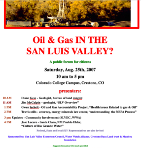
________________________________________________________________
November 15, 2007: Letter to Environmental Groups
Lexam Explorations, Inc. to drill three 14,000’ gas test wells on the new Baca National Wildlife Refuge
Giant energy companies, including Conoco-Philips and Lexam Explorations, Inc. are pushing to drill three 14,000 foot exploratory gas wells beneath Colorado’s spectacular Baca National Wildlife Refuge (BNWR) in the San Luis Valley. Lexam’s geological consultants believe there is good potential for discovering billions of dollars worth of natural gas here: Their seismic studies show the San Luis Basin formations are “remarkably similar” to those of the nearby San Juan and Raton Basins, located about 100 miles to the southwest and 60 miles to the southeast of the San Luis Basin, respectively, which have already produced trillions of cubic feet (tcfs) of gas, including conventional and much dirtier coalbed methane gas.
However, the Baca National Wildlife Refuge in the pristine San Luis Valley of southcentral Colorado, sits on the North America’s largest and perhaps most valuable freshwater aquifer. This aquifer includes an estimated 140+ million acre-feet of water and is potentially worth hundreds of trillions of dollars! This water feeds the Rio Grande River, which is allocated to three states (Colorado, New Mexico, and Texas, as well as Mexico, under the Rio Grande Compact. Unfortunately, based on the demonstrated record of gas companies elsewhere, there is a virtual certainty that the processes of drilling, fracturing, and seepage and evaporation from surface ponds processes would significantly contaminate water quality. Indeed, the toxic suite of (carcinogenic) chemicals used in the fracturing process alone essentially comprise a laundry list of chemical warfare.
In addition to contaminating surface and groundwater, drilling would also threaten and despoil wildlife and archaeological in the BNWR. In addition, the health of nearby communities is put in grave jeopardy by effects of air and water pollution, increased heavy traffic, boom-town effects, etc. . evaporation ponds is an important calving ground for deer and elk and provides a natural sanctuary to threatened or endangered wildlife, including the bald eagle, the greater sandhill crane, and mountain plover. World-class archaeological sites dating back some 11,500 years have been found nearby in the Great Sand Dunes National Park. proposed drilling threatens to transform the pristine San Luis Valley into an industrial zone of drill pads, roads, toxic evaporation ponds, processing plants, etc. gas- either conventional or coal-bed methane-
Ron Garcia, Manager of the Wildlife Refuge, is currently in the process of negotiating with Lexam the conditions of the drilling permit to be issued by the Colorado Gas and Oil Conservation Commission. At recent meetings facilitated by the Sonoran Institute, a small group of Baca residents was formed that is now working with Garcia to identify “best management practices” and guidelines to help minimize environmental and social impacts of the drilling. This group is currently developing talking points (concerns) to help educate the community on these issues. We have identified the following areas of concern: 1) preserving water quality of the aquifer for farmers and local and downstream users, 2) protecting vegetation, wildlife and native American sacred sites, 3) minimizing air, water, noise and light pollution, and 4) mitigating impacts on traffic, emergency services, and potential “boom town effects,” etc. We are now consulting with Peggy Utresch of the Grand Valley Citizens’ Alliance in Newcastle, Colorado. POA members with concerns may contact Lisa Cyriaks (256-4160).
______________________________________________________________________________
Brian Macke, Director October 3, 2007
And Valerie Walker, Permitting Tech for Saguache County
Colorado Oil and Gas Conservation Commission
1120 Lincoln Street, Suite 80
Denver, CO 80203
Subject: Lexam Explorations, Inc.’s New Application for Permit to Drill in the Baca National Wildlife Refuge
Dear Mr. Macke and Ms. Walker,
Lexam Explorations, Inc. has applied for an additional permit to drill a third well, “well #7” on the Baca National Wildlife. As a resident of the Baca subdivision, I have several concerns regarding this proposed activity. I am hopeful that with a new composition of the COGCC, that you will at least maintain the level of requirements (i.e., the 17 conditions) you imposed upon Lexam for their previous two permits. Furthermore, I hope you will take this opportunity to revisit the issues afresh with your new board and the new state oil and gas laws and deny Lexam this permit based on the following factors:
1) Oil and gas development is completely incompatible with maintaining environmental conditions suitable for a newly designated wildlife refuge. The BNWR has not yet completed its Comprehensive Conservation Plan as required by the National Wildlife Refuge Improvement Act, so they have not even done a comprehensive survey of the species and ecosystems they are mandated to protect and manage for the benefit of the American people. Impacts of developing natural gas on the refuge will likely make it impossible for the BNWR to manage and protect species on that land in anything close to their natural habitat.
2) Oil and gas development is also completely incompatible with the activities and nature of human communities of this area. Crestone/Baca is filled with spiritual seekers and people interested in sustainable development who have retreated to this area because of the spectacular, pristine nature and profound silence of this area. And Valley agriculturalists would also be adversely affected if oil and gas were discovered in this area.
3) There is an estimated 140 + million acre-feet of water stored in sediments beneath the San Luis Valley. Some say it is the continents largest fresh-water aquifer. Gary Boyce of the Baca Corporation devised a scheme to sell this water to Front Range cities for $4000 to 7000 per acre foot. And our freshwater aquifers, both unconfined and confined, occur adjacent to the deserts of the American Southwest, the driest portion of our nation. Imagine the potential value of this resource in the future! It’s in the hundreds of trillions of dollars (140 million times $5000 = $700 trillion!). Furthermore, global warming models show Colorado with 30% less moisture by the year 2050. In addition, the San Luis Valley aquifers feed the Rio Grande River, which runs through Alamosa. And water from this drainage system is currently allocated to three states (Colorado, New Mexico and Texas) and Mexico via the Rio Grande Compact. Surely, any diminution of water quality and quantity caused by oil and gas development in the SLV would therefore adversely affect quality and quantity of water available here and downstream. Thus, the present and future value of the water resource in the SLV is dramatically greater than that of a potential, temporary gas bonanza- and this water resource must be protected and guarded for the future. And clearly, a complete hydro-geologic study of the San Luis Valley aquifer systems is needed to begin to understand the potential impacts of groundwater contamination of any drilling and gas production here.
4) Massive reserves of coalbed methane (CBM) gas are now being exploited in the nearby Raton and San Juan Basins, located about 60 and 100 miles to the southeast and southwest of the BNWR, respectively. Geologically speaking, then, there is a reasonable likelihood it also occurs in San Luis Basin sediments as well. (Coalbed methane reserves for the San Juan and Raton Basins are enormous- and are estimated at 90 and 10 trillion cubic feet, respectively) Using current industry practices, then these fields can support many, many thousands of gas wells.) Extraction of this “unconventional source” of natural gas is considerably messier and more damaging to aquifers than that of “conventional” gas reservoirs. And although drilling techniques are similar to those used for conventional wells, the completion practices and the method of reservoir evaluation are different. Thus, “the BLM has adopted COGCC order number 112-61, which requires that production casing of all coalbed methane wells be cemented from producing horizon to surface by grout circulation methods.” (http://oil-gas.state.co.us/Library/sanjuanbasin/blm/Background/cbch4res.htm). This is done to try to minimize the inter-zonal flow of fluids between producing horizons and aquifers within the casing annulus.
Indeed, one of the main methods used to produce CBM is the “cavitation method,” which creates a cavity in the targeted coal seams by altering the velocity of the gas escaping from the coal reservoir. This effectively enlarges the original well bore- thus virtually ensuring the mixing of hydrocarbons, produced water, with aquifer water. And the “produced water” associated with this kind of operation is typically very saline and sodic, so the responsible disposal of this water can be very problematic. (In 1998, the last year for which statistics are available, over 597 million gallons of water were produced from Las Animas County methan wells in the Raton Basin.) Although Lexam claims to be targeting “conventional sources” of natural gas, the fact Cretaceous formations with coalbeds (the Vermejo and Raton Formations in the Raton Basin and the Fruitland and Menefee Formations in the San Juan Basin) overlie the Dakota formation, indicates there is a reasonable chance these formations would be encountered in drilling. Again, double concrete casing of drill holes for the entire 14,000 well would be a minimum precaution.
5) Lexam’s own website indicates that the Cretaceous sub-basin extends both north and south of their recent 3D seismic survey, hence obviously they believe they are targeting a massive gas field. Their exploitation of this resource would bring wind-fall profits for investors, it would also likely have massive adverse impacts on our Valley’s pristine environment and our precious acquifers.
6) Our Crestone/Baca community has the serious problem of very limited access. There is only one road in and out- the County T road. If there is an accident or fire associated with Lexam’s operation, there could be a real disaster here. Therefore, Lexam should not be issued a permit to drill on the BNWR until alternative escape routes have been identified and engineered.
7). If comparisons with other magnificent areas in our Rocky Mountain West are extended to this region, it is most probable that the potential total amount of gas that could be recovered here might be less than the U.S. consumers would go through consumer in two weeks.
8) I have genuine and profound questions about a legal system that would allow a Canadian company to have a “private property right” on American soil that would supercede that of the surface property owner, particularly as that surface property (BNWR) is the U.S. government, i.e., the American people. This means our legal system has effectively granted a corporation (which is a legal fiction) the right to exploit and despoil surface land that the U.S. Congress as designated to be protected in perpetuity for the benefit of wildlife and for the American people. The illegal usurpation of our bill of rights rights by corporations was accomplished in a legal fraud in 1886 known as Santa Clara County vs. Southern Pacific Railroad (please see Hartmann’s Unequal Protection: The Rise of Corporate Dominance and the Theft of Human Rights). And of course the law that gave precedence to the idea that mineral rights are superior to surface rights is the 1873 Mining Act. I would argue that both of these laws are unconstitutional and therefore, invalid.
Indeed, U.S. federal and supreme courts have ruled that laws contrary to the U.S. Constitution are unlawful. For example: “All laws which are repugnant to the Constitution are null and void (Marbury vs. Madison, 5 US, 137, 174, 176). And “An unconstitutional act is not law; it confers no rights, it imposes no duties; affords no protection; it creates no office; it is in legal contemplation, as inoperative as though it had never been passed.” (Norton vs. Shelby County, 118 US 425 p. 442).
9) The sequence of economic/legal transactions which has led to this current situation is particularly suspicious, murky, and possibly odious and illegal. Most of what is now the 92,000-acre BNWR was acquired as part of the 100,000-acre Maria Luis Baca #4 Ranch by the agri-business conglomerate Arizona-Colorado Land and Cattle Company in 1962. Canadian billionaire Maurice Strong purchased the property in 1971. Saudi sheik, billionaire, and arms, gold, and drugs dealer, Adnan Khashoggi purchased major shares of the Arizona-Colorado Land and Cattle Company in 1973. (Khashoggi was later associated with the drugs/arms deals of the Iran-Contra scandal of the 1980’s*). Strong, a Canadian industrialist who has been a trusteee of the Rockefeller Foundation, has, at various times, been Vice President of Dome Petroleum, President of Power Corporation, head of Petro-Canada, Hydro Canada, Ajax, Alberta Gas Company, Ontario Hydro (North America’s largest utility), American Water Development Inc. (AWDI), Baca Petroleum Corporation, Baca Resources Ltd., and MF Strong Management. He has also founded and headed numerous non-governmental organizations such as the Canadian International Development Agency (CIDA). Strong has also been one the most powerful men in the United Nations, having organized and directed both Earth Summit I in Stockholm in 1972 and the Rio Earth Summit II in Rio de Janeiro in 1992. He was also the first director of the United Nations Environmental Programme (UNEP), and served on the U.N.’s World Commission on Environment and Development, as well as the U.N.-funded Commission on Global Governance. He also served on the Boards of International Union for the Conservation of Nature (IUCN), the World Wide Fund for Nature (WWF) and the World Resources Institute (WRI), three international NGO’s that have developed and advanced the global agenda since the early 1970’s. Strong, who was appointed by Canadian Prime Minister Brian Mulroney to the Privy Council of Canada, was also involved in huge scheme, called the GRAND, Canal, to divert water from Canada to the United States (www.discovervancouver.com/forum/topic.asp?TOPIC_ID=131262). According to Glen Kealey, one of the main purposes of the water diversion was to create a giant Chicago- Winnipeg food cartel, which was to be managed from Strong’s Baca Ranch. Although this plan was never realized, it also was never cancelled. According to Kealey, some version of it could surface again, as the present political and economic climate under NAFTA/Free Trade agreements make the project more viable.
Strong recently cut his ties with the UN after being associated with various UN scandals and conflicts of interest, such as the oil-for-food program and his secret dealings with North Korea (http://www.foxnews.com/story/0,2933,250789,00.html). And he is being sued by San Diego class-action shark Milberg Weiss for dumping his shares of Molten Metal Technology at around $31/share a month prior to the stock’s October, 1996 collapse (two years later they were worth 13 cents/share.). Due to Strong’s and Molten Metal’s ties with presidential candidate All Gore, this issue has surfaced in Senate hearings on corrupt campaign financing (FORBES, Jan. 22, 1996 and Apr. 21, 1997).
In “Maurice Strong: The new guy in your future! (http://www.sovereignty.net/p/sd/strong.html), Henry Lamb stated: “After establishing UNEP (the United Nations Environmental Program) and setting its agenda, Strong returned to Canada where he resumed chairmanship of both Petro-Canada and the IDRC (International Development Research Center). He was introduced to Scott Spangler, who ran a Texas company called ProChemCo. Strong’s partnership, Stronat, bought ProChemCo., and changed the name to Procor, which immediately entered into a complex $10 million deal to acquire AZL, also known as the Arizona-Colorado Land and Cattle Company. AZL’s major stockholder was Adnan Khashoggi. In the end, AZL acquired Procor, but Strong landed in control of the conglomerate that owned feed lots, land, gas and oil interests, engineering firms, and 200,000 acres which included the Baca ranch in Colorado. Amid this multi-national deal making, Strong became President of the World Wildlife Fund (WWF), a post he held until 1981.”
So we see a confusing but recurrent pattern: Strong consistently uses his insider business connections to personally profit from international development projects which often are disguised as environmentally beneficial. As chairman and principle shareholder of Arizona-Colorado Land and Cattle Company, Strong was sued for allegedly hyping the stock ahead of a merger that eventually failed. As head of AWDI (American Water Development, Inc.), Strong made an unsuccessful bid to export the water from San Luis Valley aquifers to the Front Range. As Secretary-General of the 1992 UN Conference on “Environment and Development” in Rio de Janeiro, Strong helped draft and usher into completion “Agenda 21,” which was adopted at the 1992 Rio Summit. Though this document purports to protect the environment, it is in reality a way to secure control of natural resources (http://www.freedom21santacruz.net/site/article.php?sid=443). Elaine Dewar, author of Cloak of Green, states: “I was beginning to understand that the Rio Summit was part of a Rockefeller-envisioned Global Governance Agenda that dated back before World War II.”
But back to the Baca: It was Strong who severed the mineral rights from the surface rights on the Baca Ranch. The mineral rights and surface rights have each changed hands several times, subsequently. Lexam Explorations, Inc. purchased their interest in the mineral rights from Baca Minerals and the Newhall Land and Farming Company in 1987. Canadian billionaire, Rob McEwen, CEO of Goldcorp, purchased Goldcorp’s 49.8% share of Lexam in 2005 for $400,000 (Canadian), or 2 cents a share. The last quarterly financial statement shows that Lexam is now worth $12 million. At the time when The Nature Conservancy acquired the Baca Ranch from Gary Boyce’s Baca Corporation and when federal government acquired the Baca Ranch from The Nature Conservancy for about a few years later for about $34 million, the mineral rights could have been purchased for as little as $1 million. Why were the mineral rights not acquired then along with the surface title? Although some our local citizens have tried to find out by accessing the pertinent sale documents through the Freedom of Information Act, they have not been allowed to view those documents. Hence, the question must be asked: Is there a government-corporate plan to control the mineral and/or water resources on the BNWR? Until these issues are resolved in a transparent way, drilling should not go forward on the BNWR.
Abraham Lincoln best described democracy as “government of the people, by the people and for the people.” This requires that elected officials and non-elected officials such as Maurice Strong conduct their affairs in transparent and legal manner for the benefit of all. It seems that there may have been a wide departure from these principles in the case of the land deals that lead to the application of this present permit. Indeed, writer Jim Hightower (Thieves in High Places: They’ve Stolen Our Country and It’s Time to Take it Back) documents the systemic looting of federal treasury by the “kleptocracy.” Therefore, until transparency of government is at last achieved and until the necessary environmental studies are conducted in this case, I hope you will see fit to place a moratorium on resource development in this very beautiful corner of the state.
Thank you for considering these concerns. We, the affected citizens of the San Luis Valley, count on you doing the right things to protect our environment and our aquifers.
Sincerely yours,
Dr. Eric T. Karlstrom
Professor of Geography
Member, Water Watch Alliance
P.O. Box 54, Crestone, CO 81131
Cc: Governor Bill Ritter
Senator Ken Salazar
Senator Wayne Allard
Representative John Salazar
State Senator Gail Scwhartz
State Representative Tom Massey
Saguache County Commissioners Linda Joseph, Sam Pace and Michael Spearman
Mike Blenden, BNWR
Peter Gintautas, COGCC
References Cited
Citizens Rule Book: Bill of Rights, Jury Handbook. Whitten Printers, Phoenix, AZ.
Dewar, E., 1995, Cloak of Green, The links between key environmental groups, government and big business, Lorimer.
Hartmann, T., 2002, Unequal Protection: The Rise of Corporate Dominance and the Theft of Human Rights, Rodale, 360 pp.
Hightower, J., 2003, Thieves in high places: They’ve stolen our country and it’s time to take it back, Viking Press, 280 pp.
Palast, G., 2003, The best democracy money can buy; The Truth about corporate cons, globalization, and high-finance fraudsters., A Plume Book, 370 pp.
* Investigative reporter, Greg Palast has this to say about Khashoggi in The Best Democracy Money Can Buy: “Adnan Khashoggi, the Saudi arms dealer, the “bag man” in the Iran-Contra arms-for-hostages scandals. The man who sent guns to the Ayatolla…. and ultimately put up the money on the Nevada (gold) mine. You may recall that Bush (I) pardoned the coconspirators who helped Khashoggi arm the Axis of Evil, making charges against the sheik all but impossible.”
_______________________________________________________________________________
September 30, 2007:
Dave Montgomery 9/29/07
San Luis Valley Ecosystem Council
537 Main Street
Alamosa, CO 81101
Dear Christine,
The financial and professional relationship between Water Watch Alliance (WWA) and your San Luis Valley Ecosystem Council (SLVEC) has unfortunately been rather poorly-defined and murky. Whereas SLVEC has been in existence for nearly 20 years, our group of Crestone/Baca volunteers (WWA) began in the fall of 2006, as an attempt to respond to the fact that a Canadian corporation, Lexam Explorations, Inc., is planning to drill of two 14,000’ gas test wells on the Baca National Wildlife Refuge. During the fall of 2006, we (WWA) realized we needed to find an umbrella organization with 501c3 status so that we could collect funds to cover our expenses. You volunteered the SLVEC last fall and we agreed that SLVEC would be our financial umbrella. This summer (2007) you informed our group that you had spent the entire $8700 we had raised for WWA in a letter-fundraising appeal and that we (WWA) were broke. In fact, it appears that you have spent WWA funds as if they belonged only to SLVEC.
In order to clarify the historical relationship between WWA and SLVEC, I would like to revisit to the following facts: During the fall of 2006, the WWA organized two large community meetings at which we showed the film, “A Land Out of Time,” which generated considerable community interest. We followed this up with a fund-raising letter for WWA which we sent out jointly on December 4, 2006. The letter is an appeal from the WWA to our local community, is signed by yourself, Lisa Cyriaks, Eric Karlstrom and David Bright, and states that donations to WWA are payable to the San Luis Valley Ecosystem Council. By your reckoning $8,700 was raised for the WWA by this effort.
As I understand it, 501c3 non-profits are under legal obligation to follow rather strict rules regarding the expenditure of funds: Namely, 1) funds cannot be spent without prior approval by a vote of the association, 2) minutes need to be supplied to the group that account for the expenditure of all funds, and 3) non-profits must use appropriate parliamentary procedures in the process of dispersing funds.
The recollection of the members of our WWA is that: 1) we never designated or authorized you to dispense WWA funds, 2) you never requested our approval for expenditure of these funds, 3) you never notified us that you were going to spend the funds, 4) you never reported in any minutes how the funds were going to be spent, 5) you paid yourself most of the funds (about $5000), and 6) you failed to give our group an accounting of the benefits to our group which accrued from expenditure of the funds and your activities on our behalf.
At a WWA meeting in August, I asked you to supply us with an accounting of your expenditure of WWA funds. A couple weeks later, you furnished me (E. Karlstrom) with two informal documents, including 1) a document entitled “Chris’s Hours,” a rough accounting of hours you spent on the Lexam issue presumably on behalf of WWA, and another entitled, “Lexam Statement of Activities- Detail, All Transactions.” Whereas the “Chris’s Hours” document mentions WWA twice, the other document does not mention WWA at all. Rather, it appears that you assumed the $8,700 belonged solely to SLVEC and that you therefore had complete power and authorization to spend the funds as you saw fit.
These documents indicate that of the $8700 raised for the WWA, $3500 were spent on legal fees and that another $4984 were spent on payroll expenses. You personally claim to have worked and paid yourself for 195.5 hours on behalf the Lexam cause (at $20 per hour, this totals $3910). The document entitled “Chris’s Hour,” indicates that you are billing us for the following activities: 1) fundraising letter, thank you notes, meeting at the BNWR, going over books, attending Lexam (presumably WWA) meetings at the Manitou Foundation, distributing packets, legal research, meeting with Foundations in Washington DC, writing Lexam press releases, etc. (documents attached). In fact, this document indicates that you coordinated your activities with the Manitou Foundation and that you took a trip back to Washington, D.C. Again, however, you never informed our group of these activities or of the benefits to our group which might have accrued from these activities.
In essence, WWA is satisfied that the $3500 spent on legal fees is money well spent. But given that we never authorized you to pay yourself out of WWA funds and never authorized you to spend those funds on your activites, we would request that you would reimburse WWA for the remainder of the funds, i.e. $5,200.
Sincerely,
Eric Karlstrom
Lisa Cyriaks
Water Watch Alliance
_____________________________________________________________________
November 29, 2007;
Dave Montgomery 9/29/07
San Luis Valley Ecosystem Council
537 Main Street
Alamosa, CO 81101
Dear Dave,
Thanks for your letter of September 13 in which you thank the Water Watch Alliance (WWA) for helping to protect the BNWR from potential oil and gas development. We agree that WWA will be most effective by maintaining its own autonomy from SLVEC. Indeed, it has always been important that we remain autonomous from SLVEC. We also agree that WWA and the SLVEC face some major challenges in the near future and we also hope we can cooperate in our efforts to keep Lexam Explorations and ConocoPhillips from turning our Valley into an industrial gas park.
Unfortunately, since December, 2006, the financial and professional relationship between WWA and SLVEC has been rather poorly-defined and murky. WWA had its beginnings as a group of local volunteers who began studying the potential impacts of Lexam’s gas drilling in about September, 2006. We soon realized that we needed funds to continue our work and since Christine Canaly had begun attending our meetings, she volunteered the SLVEC to become our financial umbrella organization. In December, 2006, WWA and SLVEC sent out a fundraising letter for WWA, from which we raised about $8700. This summer (2007), Christine informed us that she had spent all the funds, and indeed, had used over half the funds to pay herself for work.
As I understand it, 501c3 non-profits are under legal obligation to follow rather strict rules regarding the expenditure of funds: Namely, 1) funds cannot be spent without prior approval by a vote of the association, 2) minutes need to be supplied to the group that account for the expenditure of all funds, and 3) non-profits must use appropriate parliamentary procedures in the process of dispersing funds.
Our recollection is that: 1) WWA never designated or authorized Chris Canaly to dispense WWA funds, 2) Chris never requested our approval for expenditure of these funds, 3) she never notified us that she was going to spend the funds, 4) she never reported in any minutes how the funds were going to be spent, 5) she paid herself most of the funds (about $5000), and 6) she failed to give our group an accounting of the benefits to our group which accrued from expenditure of the funds and her activities on our behalf.
At a WWA meeting in August, I asked Christine to supply us with an accounting of her expenditure of WWA funds. A couple weeks later, she furnished me (E. Karlstrom) with two informal documents, including 1) a document entitled “Chris’s Hours,” a rough accounting of hours she spent on the Lexam issue presumably on behalf of WWA, and another entitled, “Lexam Statement of Activities- Detail, All Transactions.” Whereas the “Chris’s Hours” document mentions WWA twice, the other document does not mention WWA at all. Rather, it appears that she simply assumed the $8,700 belonged solely to SLVEC and that she therefore had complete power and authorization to spend the funds as she saw fit.
These documents indicate that of the $8700 raised for the WWA, $3500 were spent on legal fees and that another $4984 were spent on payroll expenses. Christine claims to have worked and paid herself for 195.5 hours on behalf the Lexam cause (at $20 per hour, this totals $3910). The document entitled “Chris’s Hour,” indicates that she paid herself for the following activities: 1) fundraising letter, thank you notes, meeting at the BNWR, going over books, attending Lexam (presumably WWA) meetings at the Manitou Foundation, distributing packets, legal research, meeting with Foundations in Washington DC, writing Lexam press releases, etc. (documents attached). In fact, this document indicates that Christine coordinated her activities with the Manitou Foundation and that she also took a trip back to Washington, D.C. (using WWA money?) Again, however, Chris never informed our group of these activities or of the benefits to our group which might have accrued from these activities. It is important to stress that all other members of WWA have donated their time to the Lexam cause. Thus, it becomes a matter of particular importance if someone in the group should begin to receive pay. Again, this discussion never took place.
In essence, WWA is satisfied that the $3500 spent on legal fees is money well spent. However, because Chris Canaly designated herself rather than WWA as the client, members of our group have not ready access to the lawyers or their advice. Even so, we would hope that Christine and SLVEC will keep us informed regarding the progress of this important legal case. But given that we never authorized Chris to pay herself out of WWA funds and WWA never authorized her to spend those remaining funds ($5200), we request that the SLVEC reimburse WWA the remainder of the funds spent without our knowledge or approval, i.e. $5,200.
Sincerely,
Eric Karlstrom
Lisa Cyriaks
Water Watch Alliance
Cc: Christine Canaly
Phil Madonna
_______________________________________________________________________________
November 24, 2007:
Dave Montgomery 11/24/07
San Luis Valley Ecosystem Council
537 Main Street
Alamosa, CO 81101
Dear Dave,
Thank you for your letter of September 13 in which you thank the Water Watch Alliance (WWA) for helping to protect the BNWR from potential oil and gas development. We agree that WWA will be most effective by maintaining its own autonomy from SLVEC. And it seems that other groups are springing up as well to try to deal with the issues and problems of Lexam’s proposed drilling on the BNWR. We hope the diversity of groups will help our cause. Certainly, WWA and the SLVEC face some major challenges in the near future and we hope we can cooperate and communicate with each other in our order to better respond to the challenges of Lexam’s and ConocoPhillips’ proposed drilling.
A fund-raising letter put out by WWA last fall resulted in raising about $8700 in local contributions. We at WWA still have some questions as to how this money was spent since we were never consulted as to how it would be used. Christine Canaly of SLVEC provided us some accounting which shows she used about $3500 of the money on legal fees and spent the remaining approximately $5000 to pay herself for her own activities. Since WWA money was used to pay lawyers Travis Stills and Brad Bartlett of the Energy Minerals Law Center, we believe it would only be fair that a member of our group be granted the opportunity to communicate directly with these lawyers so that we can better understand which legal strategies are being pursued. This may be particularly important now, as we expect the BNWR to come out with the results of its EA/Scoping Process very soon. We appreciate SLVEC’s continuing efforts on behalf of keeping our pristine San Luis Valley free from gas drilling.
Sincerely,
Eric Karlstrom (P.O. Box 54)
Water Watch Alliance (P.O. Box 653)
Crestone, Colorado 81131
Cc: Christine Canaly, Director of SLVEC
Phil Madonna, Board member of SLVEC
Brad Bartlett, Energy Minerals Law Center, 1911 Main Avenue, Suite 238, Durango, CO 81301
Travis Stills, 1831 Forest Avenue, Durango, CO 81301 Western Resources Legal Council
________________________________________________________________________
10/26/06
Lexam Talking Points-
E. Karlstrom- 10/26/06
I. History of Lexam – (www.lexamexplorations.com) and its “drill play on the Baca Wildlife Refuge”
1) Lexam Explorations Inc. (Lexam) is a Toronto, Canada-based, exploration company that incorporated in 1983. It changed its name from Challenger Gold to Lexam when it went public.
2) Lexam’s management team, headed by Canadian billionaire Rob McEwen, former CEO (and current largest shareholder) of Canda’s Goldcorp Inc. and now head of U.S. Gold, oversaw development of Red Lake Mine, Canada’s largest gold mine.
3) Lexam purchased 50% of the hard mineral rights from Baca Minerals in 1987 and the other 50% of the oil and gas rights on the Luis Maria Baca Grant No. 4 from Newhall Land and Farming Company for $1 million. It acquired the additional 25% of the oil and gas rights from the Baca Corporation in 1996 from Gary Boyce for $1 million. Lexam also owns various interests in varying percentages of the hard mineral and oil and gas rights on land to the north and west of the Grant. The remaining 25% of oil and gas rights is owned by ConocoPhillips. But there is currently no agreement between Lexam and ConocoPhillips.
4) Lexam acquired surface access and use by fee simple ownership and a Surface Use Agreement with American Water Development, Inc. (AWDI) in 1992 for $1 million. This agreement is a 20-year paid-up lease that is binding on surface owners who may be successors in ownership to AWDI. This agreement can be extended if there is production on the property.
5) Surface rights are currently owned by the Nature Conservancy, but there is an intent to eventually convey ownership of the surface to the Federal Government (USFWS and NPS).
6) To date, there is no indication the Federal Government wants to acquire Lexam’s mineral rights.
7) Rob McEwan purchased Goldcorp’s 49.8% of Lexam in August, 2005, for $400,000 (Canadian) or 2 cents a share. As of July, 2006, that share is worth $12 million.
8) Drilling of two new, 14,000 exploratory wells on the Crestone East Prospect (Baca #5 and # 6 wells) are considered high risk (“wildcat”), but Lexam believes there is significant potential of discovering large amounts of gas and oil in the San Luis Basin. This depends upon two main “risk factors:” 1) the presence of favorable source rock (mainly Cretaceous Mancos Shale and Dakota Sandstone) and sealed traps. To determine actual presence of the various factors requires drilling.
9) Lexam is now applying for permits from the Colorado Oil and Gas Conservation Commission to drill these two 14,000 test wells in the deepest part of the basin that has never been drilled. Details include reclamation plan, processes to be used, protections to be offered/required, proposed well design, etc..
10) Lexam plans to spend about US $1.4 million to conduct 3D seismic survey (slated for January or February, 2006) and another US $8.5 million on drilling the two exploratory wells (slated for late 2007 or early 2008).
11) Currently, Lexam owns the subsurface mineral rights and the U.S. government (USFWS) owns the surface and water rights.
II. Geographical/geological context of the San Luis Basin
1) The Baca Grant property (100,000 acres) is part of the San Luis Basin, a graben that extends north of the Rio Grande Rift in New Mexico. The basin includes two half grabens, the western Monte Vista Graben and the eastern Baca Graben, separated by the Alamosa Horst. Depth to Precambrian basement rocks in the Baca Graben is estimated at about 14,000 feet. Sediments and sedimentary rocks within the Baca Graben include, from top down, the Pliocene to Pleistocene Alamosa Formation and the Miocene Sante Fe Formation, as well as possibly Mesozoic sedimentary rocks (Cretaceous Mancos Shale and Dakota Sandstone, and Jurrasic Morrison Formation) and Permo-Pennsylvanian sedimentary rocks of the Sangre de Cristo Formation. Mesozoic sediments, if present, would provide the “source rock” or “reservoir rock” for gas and oil. There are two small outcrops of Mesozoic sediments near the eastern margin of the basin.
Depositional context of Mesozoic Rocks: About 65 million years ago, there was a major invasion of ocean into Colorado, which extended from the Wet Valley, across the area of the modern Sangre de Cristo Mountains and the San Luis Valley to present-day Durango, leaving beach lines and marine shales. Climate was very hot and wet at that time, and huge, peat swamps developed behind the beaches, much like the Amazon River area today. However, most of these rocks were stripped away by erosion during the Laramide Orogeny some 65 to 55 mya..
2) Until recently, it was believed there were essentially no Mesozoic sediments in the San Luis Basin. In his 1991 lecture notes, Colorado College geology professor William Fischer stated:
On the east side of the range, in an overturned anticline at Loco Hill, there are small exposures of Jurassic Entrada sandstone and Morrison shale: no record of either Triassic or Cretaceous time is known. Beginning in late Cretaceous time and extending into the Eocene the region was subjected to intense compression creating anticlinal and synclinal folds that were subsequently cut by numerous west dipping low angle thrust faults. Crustal shortening within the range is estimated at 8 km at the latitude of Westcliffe and 14 km near the latitude of the Great Sand Dunes. This mountain building event is known as the Laramide Orogeny and crustal compression appears to have been mostly unidirectional and from the west. From this time and up to the present, the area has remained continental.
Beginning in Oligocene time (ca. 36 mya), the stress pattern shifted from crustal compression to crustal extention. Plate tectonic models visualize either a spreading center or a mantle plume developing pull apart forces which create normal high angle faults on either side of the range, the Sangre de Cristo fault on the west and the Alvarado fault on the east. Between these bounding faults the Sangre de Cristo horst began to rise as the San Luis Graben subsided, thus marking the inception of the Rio Grande Rift. With continued uplift of the mountains and subsidence of the San Luis Basin, we end up with about 28,000 feet of basin fill adjoining peaks that are in excess of 14,000 above sea level…
Since the inception of rifting, the San Luis Basin has been subsiding as it was filled with alluvium. All streams draining the mountains disappear in the alluvial fill, thus creating the vast reserves of ground water.
3) But in the early to mid 1980’s, oil geologists investigated the valley between Monte Vista and Wolf Creek Pass and between Crestone and the Great Sand Dunes, and started finding Mesozoic Rocks. Then, 27 of 42 shallow exploration drillholes drilled by Challenger Gold Inc. in 1992 and 1993 encountered oil in “fractured Precambrian rocks and Mesozoic sediments.” 17 of these hit Mesozoic sediments that occur as rotated fault blocks in the hanging wall of the basin-bounding detachment fault. Geological consultants from Toronto (WGM) believe that the seismic character of basin rocks are “remarkably similar” to that of the San Juan Sag to the west (where Mancos-Dakota-Morrison are present) and the Raton basin to the east.
III. History of the “Crestone Prospect”
1) Again, conventional geological wisdom up to about 1992, as shown in a geological X-section by Ogden Tweto (1979), was that the eastern part of the San Luis Basin (the Baca Graben) was underlain by about 4 km of Tertiary and Quaternary alluvial fill overlying Precambrian bedrock. It was believed that there were no Mesozoic rocks in this area because regional uplift and folding and faulting during the Laramide orogeny resulted in more erosion than deposition of sediments.
2) In 1992 and 1993, however, Challenger Gold drilled a number of exploratory wells and got “strong shows of oil” in 27 drillholes. Cretaceous Mancos Shale and Dakota Group and Jurassic Morrison Fm. rocks were identified in outcrop and in 17 shallow drillholes. Of these, Mancos Shale is thought to be an excellent source rock and Dakota Sandstone is thought to be sufficiently porous (15-21%) to hold commercial quantities of gas and oil.
3) In 1995, Lexam drilled the Baca #1 and Baca #2 wells and confirmed the presence of the Cretaceous section on the Deadman Creek block. The strongest shows of oil were in Baca #2 well at 6,620 feet in the Tertiary Sante Fe Fm., the Mancos Shale and in Precambrian gneiss.
4) In 1996, Lexam acquired 20 miles of seismic data and 221 gravity data points, which strongly support the presence of a thick Cretaceous to Jurassic section in the Baca Graben. Integrating this seismic data with previous seismic data, they were able to delineate a large structural closure (the Crestone Prospect) at 7000 to 12,000 feet, with both trap types present.
5) In 1998, SONAT acquired 31 miles of 2D seismic data over the Crestone Prospect which also confirms closure of Crestone structures.
6) In 1999, SONAT relinquished its option agreement on this seismic data with Lexam. (why?)*.
7) In 1999 – 2000, Lexam acquired and reinterpreted seismic line CF-8402 that suggests gas in Tertiary sediments above the Crestone Prospect.
8) In 2002-2004, Petro-Hunt acquired, processed and interpreted another 60 miles of 2D seismic data in 2004 and bought and reinterpreted another 50 miles of Chevron 2D seismic data. Petro-Hunt relinquished this option to Lexam in December, 2004.**
9) In March 2005, Lexam purchased this seismic data for $419,000, which indicates that “closure” (i.e., a trap) is better defined for the Crestone East block than the Crestone West block.
10) Today, Lexam’s primary targets are the Crestone East (4060 acres) and Crestone West (6,945 acres) prospects located in NW quadrant of their property. In addition, at Pole Creek (SE part of Baca Land Grant), a shallow 1.3-acre oil target is present in land overseen by the NPS.
11) WGM consultants from Toronto* believe that the Baca Graben contains Mesozoic rocks about 3000 feet thick at depths of 7000 to 17,000 feet. Two types of structural traps have been mapped seismically: closed-structure anticlines and rotated fault blocks close to the margin of the basin. WGM notes that all basins surrounding the San Luis Basin with Cretaceous rocks at depth (over 8000 feet) have significant oil and gas accumulations. These include the San Juan, D-J, Raton, and Piceance Basins. (The San Juan Basin has produced over 25 trillion cubic feet of gas.)
12) Lexam hopes that over 100 and up to 550 square miles of the Crestone sub-basin contains a 2000 to 3000 ft. thick package of Cretaceous rocks at depths of 7000 to 17,000 feet.
* You have to wonder why Lexam did not use local consultants…..
** You have to wonder why Sonat and Petro-Hunt sold their seismic data if the results were so promising.
*** Also note the list of players includes AWDI (Maurice Strong), the Baca Corporation (Gary Boyce), Baca Minerals, Petro-Hunt, Chevron, SONAT, Conoco-Phillips, Nature Conservancy, and the Federal Government (USFWS).
IV. Primary risk factors of the project for Lexam
Their risk factors-
1) Presence or absence of favorable reservoir rock is not known.
2) Do the interpreted structures (anticline and rotated fault blocks) constitute “sealed traps” that would hold the gas/oil?
3) They are still raising funds for the exploratory drilling and 3-D seismic investigations (about $12 million required).
4) McEwen is currently engaged in a legal battle with Goldcorp.
5) The nearest gas pipelines are 30 miles away. Lexam would either have to truck it out or build pipelines.
More potential risk factors for Lexam
6) Identification of threatened or endangered species on Wildlife Refuge or federal requirement of conducting an environmental impact statement (EIS). Potential law suit from Malville, etc.
7) Cultural Resource Survey along the seismic lines, to be conducted by Maria, Inc. of Laramie Wyoming, could identify native American sites that would require either excavation or protection under federal laws.
8) Possible law suits by Rio Grande Water Conservation District to protect quality of aquifer for local farmers and downstream users.
9) Community input in the permitting process.
10) Potential law suits from spiritual groups or native American advocacy groups pertaining to Executive Order 13007 (1996) and the 1978 American Indian Religious Freedom Act which are meant to protect unimpeded access to sacred sites.
11) Other-
V. Peggy Utresch- of Rifle, Silt, New Castle: Recommendations
1) Oil and gas is the single richest industry in the world. You can’t sue them because all the laws are in their favor. Therefore, we can’t stop the drilling of these test wells.
2) There is very little inspection and oversight of these kinds of wells elsewhere, therefore we need to force accountability.
3) We need to try to establish guidelines ensuring closed-loop water system, concrete casing of entire wells, and close monitoring of water quality. In addition, we need quidelines to ensure:
a) cluster development, directional drilling,
b) continuity of development and organized development,
c) best management practices, such as cluster placement of pipelines, designated truck routes, noise and light mitigation, removal of waste water, combustion equipment to burn up emissions, dust mitigation, use of green fracing fluids,
d) sharing drilling plans with community,
e) allowing monitoring of activities, (get copies of rules and regulations),
f) control noxious weeds,
g) develop plan for community health and safety- develop emergency response plan
h) community education- re: roads and traffic issues, water issues, financial impacts, etc.
i) create community board to oversee process
4) Problem: A Community Development Plan is not legally binding.
VI. Environmental issues
1) Subsurface issues include quality of groundwater, shallow well impacts, casing protocols, the fluids used,
2) Surface issues include permeable and sandy soil type, mixing of surface and ground water near the location of well #5, sensitive vegetation and wildlife, creation of ruts by large vehicles, road/traffic dust, waste disposal, air pollution, archaeology, reclamation.
3) Towers will be 130 feet high.
VII. Community Impacts
1) noise, light, hours of operation, seismic activity, emergency services, roads, “boom town” effects.
_____________________________________________________________________________
9/5/07
Mike Blenden
U.S. Fish & Wildlife Service
Baca National Wildlife Refuge
Alamosa/Monte Vista National Wildlife Refuge Complex
9383 El Rancho Lane,
Alamosa, CO 81101
Email: mike_blenden@fws.gov
Comments and Concerns Re: proposed exploratory gas-well drilling by Canadian firm, Lexam Explorations, Inc. on Baca National Wildlife Refuge
At a recent meeting with our Crestone/Baca community (8/17/07), the USFWS initiated an EA/scoping phase of the NEPA process, requesting that local citizens write-in our concerns re: the proposed drilling of two 14,000’ gas test wells by a Canadian corporation, Lexam Explorations, Inc., on the BNWR. We of Water Watch Alliance (WWA, formerly San Luis Valley Citizen’s Alliance) and I as a citizen of the Baca have many concerns regarding the adverse impacts of Lexam’s proposed drilling on sensitive wetlands of the Wildlife Refuge within 1.5 miles of the Baca community. It is our (WWA) opinion that there are numerous reasons that gas and oil exploratory drilling on the Baca Refuge constitutes an “incompatible use” with that of protecting and preserving fish and wildlife habitats as well as the health and viability of human communities and agricultural operations in the San Luis Valley (SLV). In addition, “downstream” communities in New Mexico, Texas, and Mexico, located in the lower portions of the Rio Grande drainage basin, may also be adversely affected by contamination of surface water from the drilling project. The rights of these downstream users are protected by the Rio Grande Compact. We conclude that: 1) many of the inevitable damages caused by gas exploration drilling in this sensitive area cannot be mitigated and therefore should not be allowed, and 2) due to directives from Washington, D.C., the USFWS is out of compliance with many of the federal regulations it is bound by law to follow and enforce.
It is mandated by law that the BFWR conduct a full-blown NEPA process. Even so, the BNWR announced last fall that it was not required to conduct a NEPA process. Today, it is conducting this process, but only in response to a lawsuit filed by our SLVEC/WWA lawyers. The BNWR is now conducting an Environmental Assessment, which suffices as the short version to fulfill legal requirements when the proposed activity is found to cause no significant impacts. However, given the well-documented, adverse impacts of gas drilling elsewhere in Colorado and the West (OGAP, 2005) and given the extremely sensitive nature of wetland ecosystems and aquifers on and under the Baca Wildlife Refuge, we of WWA believe that the USFWS is legally and morally obligated to conduct a full-blown EIS (Environmental Impact Statement) as well as complete their own Management Plan before allowing any drilling to occur on the Refuge. By conducting a full-scale Management Plan, the BNWR will be able to establish base-line data on air quality, water quality, and the ecosystem itself, including delineation of sensitive species requirements, etc. We would hope these data would be shared with local and state health officials, the POA, Saguache County officials, etc. before any exploratory drilling is allowed.
Our group of concerned citizens chose to call ourselves the Water Watch Alliance because it became clear to us that the gigantic reservoir of water stored in aquifers beneath the San Luis Valley is a priceless resource both now and in the future. It is our goal to protect this resource against potential long-term contamination by large-scale gas/oil operations. We believe that an honest and adequate EIS process will indicate that drilling should not occur on the BNWR. We should be seeking federal legislation to insure that the SLV remains protected in perpetuity as a “No-Go Zone,” as the Valle Vidal and Otero Mesa of New Mexico have now been designated. Whereas the NEPA process permits federal agencies to use Environmental Assessment’s alone when there are no “unique and exceptional circumstances” and “no significant impacts,” we feel that drilling two 14,000’ gas wells through sensitive wetlands and through a series of priceless aquifers on the newly-created BNWR would certainly have significant, adverse impacts and thus, this certainly qualifies as a “unique and exceptional circumstance.”
Lexam Explorations, Inc., which owns 75% of the mineral rights, is a small Canadian company that has never operated an oil or gas well. They will use subcontractors to carry out their drilling; they don’t intend to operate anything. The remaining 25% of the mineral rights are owned by Conoco-Phillips. If Lexam “strikes it rich” and finds a “tcf” (trillion cubic feet) of natural gas, as they hope, their $20 million investment could provide a windfall financial profit for their 2200 shareholders of between $1 billion and $18 billion. Lexam would then immediately sell out to major oil companies such as Conoco-Phillips, which would then proceed to turn the SLV into a toxic, industrial park. I have visited the gas fields south of Silt, Colorado and talked with local property owners there whose lives have become a prolonged nightmare. People’s health, quality of life, and property values are severely and adversely impacted. In addition, it is now well understood that burning fossil fuels contributes to global climate change. One estimate is that the burning of a “tcf” of natural gas would produce about 150 million tons of carbon dioxide, a greenhouse gas. In Europe, production of this amount of CO2 would be taxed at the rate of nearly $2 billion.
William Blake’s image of “Dark Satanic Mills” dotting the 19th century English countryside might then be an apt description of what our own San Luis Valley could look like as an industrial gas field. Meanwhile, the collective benefit to the nation of a successful gas play here would be to obtain sufficient natural gas to supply the US for perhaps a couple weeks only. And the equivalent amount of energy can now be much less harmfully produced using green energy, including solar, wind, and geothermal energy, which, ironically, are very abundant in the SLV.
Adverse impacts that accompany gas and oil drilling:
1) Pollution and degradation of surface water (wetlands) and subsurface water in the unconfined and confined aquifers. Much of the BNWR consists of seasonal wetlands, which are among the most sensitive and important ecosystems in terms of their importance for supporting a large variety of species. Underneath the BNWR is 14,000’ to 15,000’ of sediments overlying Precambrian bedrock. An impermeable layer of clay, 10 to 80’ thick separates the surface (unconfined) from the subsurface (confined) aquifers. However, there are probably as many as 30 distinct aquifers contained within the confined aquifer (Dr. James McCalpin, pers. comm., 2007). Water pressure increases as you descend in the aquifer, therefore (polluted?) water will tend to rise (and mix) through the aquitards and aquifers. In the unconfined aquifer, water table is quite shallow (about 12’ or less) and hence, any addition of pollutants will likely contaminate surface water essential to a wide variety of human and non-human users, both in the near-term and in the future. This relatively shallow unconfined aquifer provides drinking water to our Baca community and most other SLV communities. It also provides the water needed for fish and wildlife, including over 70 species of rare plants and animals, agriculture in the San Luis Valley, and water usage throughout the Rio Grande basin.
There are currently about 7000 wells in the SLV, of which about 1800 are “deep wells” that penetrate the confined aquifer. There is a significant danger of contaminants from the Lexam drilling operation leaking and irrevocably polluting the San Luis Valley aquifers. If the drillers encounter the Dakota Sandstone, a “reservoir rock” that they hope to find, they will in probably use hydraulic fracturing fluids, which can be highly toxic. This poses a threat to the whole Rio Grande region’s water supply and wildlife for future generations. The state of Colorado, which technically owns most of the water, has recently imposed a moratorium on drilling in the confined aquifer. Why is Lexam Explorations, Inc. exempt from this moratorium? Given the magnitude of adverse impacts of the drilling and the potential future value of water in the aquifer (probably many billions of dollars), exploratory gas drilling is an “incompatible use” with the Wildlife Refuge.
Chemical contamination of groundwater: Dr. Theo Colborn has analyzed the chemical compounds involved in the gas well drilling process by studying Material Safety Data Sheets. Of particular concern is the process of hydraulic fracturing which utilizes a suite of especially dangerous chemicals. Such fracturing operations may require up to a million gallons of fluid per well (Gwen Eifle, OGAP, pers. communication, 2007). Colborn determined that of the 245 chemicals commonly used in drilling, 91% have adverse health effects and there is no information on the other 9%. Of the 91%, 35% are endocrine disrupters for people and wildlife. Some of the most toxic chemicals include BTEX (benzene, tolumene, ethylbenzene and xylene) which are carcinogenic, methane, diesel fuel, hydrogen sulfide, heavy metals, VOCs (volatile organic compounds), formaldehyde and PAHs (Colborn, 1997). On viewing the list of chemicals used, Professor Clay Bridgford, an ex-military man in Crestone, referred to this suite of chemicals as “a laundry list for chemical warfare.” Many of these chemicals have been found in contaminated wells and in grab samples for air quality near gas wells in Colorado and elsewhere in the west (OGAP, 2005).
According to OGAP’s Gwen Lachelt (pers. comm., 2007), due to the current industry-friendly administration, every chemical used is considered propriety by the gas and oil drilling industry and this industry is exempt from following the Clean Water Act and other laws that limit and regulate use of toxic chemicals in the U.S. Drillers also use propolene glycol (an antifreeze) on well pads. When ingested, this chemical is fatal for animals. Hence, pad areas always need to be fenced. However, in practice, they typically are not fenced (OGAP, 2005).
Even closed-loop systems still utilize open, evaporation pits, which often contaminate surface water, poison creatures, and add toxic pollutants to the air.
Inadequacy of concrete well casing: The COGCC issued a permit to Lexam specifying that they only need to use double concrete casing in the well for the upper 3500’ of 14,000’ wells. Clearly, there is great potential for contamination of the confined aquifer if the well hits gas and oil and if the casing leaks in the future. . It is well-known that cement casings lose their integrity over time and can become a source of groundwater contamination for decades and centuries (OGAP, 2005). It is also commonly known that one quart of oil can contaminate up to 250,000 gallons of water. Thus, double concrete casing should extend the entire depth of any well.
Needs of future generations: Future generations of humans and other organisms will depend on the quality and quantity of water in the SLV aquifers. A recent study on global warming concluded that by the year 2050, Colorado residents will have to subsist on 30% less water than present. Contamination of the water supply, then, could have disastrous consequences. Two individuals, Canadian Maurice Strong (AWDI) and local Colorado-resident, Gary Boyce (the Baca Corporation), tried, unsuccessfully, to make billions by exporting water from the SLV to the Denver area. So we can speculate that the value of the water is potentially as great or possibly much greater than that of any oil or gas that may be present. Clearly, more scientific studies are required to determine the potential value of the SLV aquifers as well as to determine how best to protect the quality and quantity of the aquifers.
Water from the Rio Grande River is allocated to three states (Colorado, New Mexico, and Texas) and Mexico and is regulated by the Rio Grande Compact. Potential degradation of water in the SLV aquifers could affect the quality of surface water available to downstream users in these areas in the future. We hope that the Rio Grande Water Conservation District becomes more involved in this issue to help protect water quality and quantity for farmers and downstream users.
Solution: A moratorium on drilling. Because access to fresh potable water in the semi-arid West will probably increase in the future, the Governor of New Mexico has recently imposed a moratorium on gas and oil drilling on the Otero Mesa until such scientific studies are complete. We suggest that our governor and/or our federal representatives do the same in this region.
2) Air pollution: Chemicals used in natural gas development are dangerous to the health of living creatures (animals, plants and humans) who happen to live near the drilling operations. Emissions from drilling pads emit carcinogenic toxic chemicals into surrounding public lands and communities. Ground level ozone causes degenerative health problems for humans, wildlife, plants and agricultural crops. It is the #1 cause of asthma. Because ground-level ozone is produced at every gas well pad, each well needs a special permit to exceed air quality standards required by the state and U.S. government. In addition, after gas comes to the surface, a dehydrator is used to separate the gas from the condensate, which includes a complex of volatile carcinogens, called BTEX, which includes ethyl benzene, xylene, and tolumine. In addition, PM-10 (airborne particulate matter less than 10 microns in diameter) has serious negative impacts on crops and human health. In order to monitor air quality in the BNFWR, it will be necessary to coordinate activities with the following organizations: Colorado Air Quality Control Commission, Colorado Water Quality Control Commission, Colorado Division of Wildlife, Local county weed programs, Bureau of Land Management, and Saguache County. It will also be necessary to conduct preliminary baseline studies on present air quality.
3) Health Concerns: Based on analysis of data in the Chemicals Used in Natural Gas Development Spreadsheets, Dr. Theo Colborn found that of the chemicals used, 49% can cause skin/sensory organ toxicity, 47% can cause respiratory problems, 47% are neurotoxins, 43% are gastro-intestinal/liver toxicants, 38% are kidney toxicants, 33% are carcinogenic, 29% are cardio/vascular/blood toxicants, 27% are immune system toxicants, 25% are developmental toxicants, and 13% are endocrine disruptors. In addition, of the chemicals on the list, 20% are biocide products that kill all life. Of the chemicals that are soluble in water (13%), 72% are neurotoxicants, 61% are gastro-intestinal/liver toxicants, 61% are reproductive toxicants, 61% are skin and sensory organ toxicants, 56% are respiratory toxicants, 50% are kidney toxicants, 39% are cardiovascular toxicants, 28% are endocrine disruptors, and 22% are wildlife toxicants. Furthermore, And furthermore, of the chemicals used in natural gas drilling that vaporize, 66% are neurotoxicants, 60% are gastro-intestinal/liver toxicants, 52% are respiratory toxicants, 45% are kidney toxicants, 43% are reproductive toxicants, 37% are cardiovascular/blood toxicants, 33% are carcinogens, 27% are immuno-toxicants, 14% are endocrine disruptors, and 4% are wildlife toxicants.
4) Impacts upon wildlife: Rare flora and fauna in the San Luis Valley, some found nowhere else in the world, include, the Great Sand Dunes tiger beetle, the giant sand treader cricket, the Rio Grande cutthroat trout, the southwestern willow flycatcher, and the slender spiderflower. Other species found in the area include the bald eagle, sandhill crane, pronghorn antelope, elk, mule deer, bighorn sheep, mountain goats, mountain lion and black bear.
5) Noise, light, and dust pollution: The proposed drilling, located about 1.5 to 2 miles west of the Baca residential community, will produce inevitable noise, light, and dust pollution which will degrade the quality of life for members of the Baca community as well as the habitats of fish and wildlife on the Refuge. In addition, heavy truck traffic associated with various aspects of the operation will significantly increase noise and dust. Compressor stations, if built, produce noise as loud as a jet airliner “24-7” (24 hours a day, 7 days a week. Crestone/Baca includes many spiritual groups and individuals who have moved here because of the pristine beauty of nature and the awesome and profound silence that the area affords. These spiritual groups will be adversely impacted by the drilling operations, in particular.
6) Damage to local roads due to use of heavy vehicles: We can expect that heavy traffic by heavy vehicles will result in damage to local roads and the increase of traffic accidents. Will Lexam pay for the damage their operation causes to existing infrastructure?
7) Infrastructure requirements: There is currently no infrastructure in the SLV that would support gas production. Building such an infrastructure would require construction of gas pipelines, gas compressors, building of innumerable gas well pads, building extra roads, etc. The synergistic effects of these kinds of operations would significantly degrade the pristine quality and quality of life in the San Luis Valley for many residents. Oil spills, truck crashes and highway deaths resulting from those crashes would be highly likely.
8) Boom-town effects: If Lexam strikes gas, we can expect that a suite of highly disruptive “boom-town effects” would accompany the gas boom. Other communities which have been subjected to this process have experienced varying degrees of chaos, social upheaval, negative impacts on schools, emergency services, crime rates, etc. And typically, after gas companies create problems, the local tax payers have pay the cost of the damages, road repair, etc. This pattern repeats in many ways, with local communities paying for extra schools, roads, etc. that industry needs in order to function. Meanwhile, what percentageof the profits are shared with local counties? Often, little to none.
9) Damage to local cultural, spiritual and native American values: The NEPA process requires that the USFWS try to understand the cultural values of the Crestone/Baca community. Our community is comprised of numerous communities and individuals committed to the preservation of pristine nature, developing more sustainable living models, and pursuing spiritual retreat in one of the world’s truly magnificent natural settings. Every fall for many years, for example, our town has sponsored an energy fair, which displays alternative and renewable means of creating energy. The San Luis Valley itself has long been acknowledged as one of the great spiritual centers of the world. It is commonly claimed around here that since pre-historic times when several Native American nations would gather in this “Bloodless Valley” bloodshed between peoples’ was not permitted. Mount Blanca, at the southern end of the valley, is one of the four sacred mountains of creation for Hopi and Navajo Indians. In practice, both the SLV and Mount Blanca are such recognized as cultural/spiritual sites of great importance to various Native American groups. And over the past few decades, the Baca Grande community has become home to many international spiritual centers and spiritual masters of various faiths including Christian, Buddhist, Hindu and others. These diverse cultures, faiths and retreat centers provide the sanctuary and retreat that both residents and visitors seek.
We believe that our cultural identity, our “sense of place,” and the continued health and integrity of our human and natural ecosystems is more important than Lexam’s short-term profit potential on the Toronto stock exchange. In practice, these “wild-cat” speculators are not only trying to mine for resources, they are also mining their own investors. It seems these people are motivated more by short-term personal gain than by a larger vision for or commitment to the future of our society or our environment. The fact that they are from Canada means they have little or no understanding of or regard for the values of our community. To us, national security or “homeland security” means clean air and water, a healthy environment, healthy communities, safe neighborhoods, healthy food, and minimum impact on the physical environment, etc. Certainly, our idea of prosperity is not compatible with a quick “wild-cat” gas play. To us, the potential threat by the Lexam drill play to the water and ecosystems of the SLV is not an acceptable risk. By contrast, we note and are concerned by the cynical, “public be damned” attitude typical of fossil fuel companies and “the oilies”. In a moment of candor, one industry geologist reportedly admitted to the Colorado legislature: “The industry is not happy until there is a hole drilled every 40 acres.”
Perhaps the inevitable question now is: Is the fossil fuel industry today more powerful than the U.S. government? Given that our president and vice president are both fossil fuel industry insiders and have manipulated our government so as to remove the impediments of federal regulations in an effort to maximize industry’s profits, it seems that yes, the oil/gas companies are now more powerful than our government.
Bitter Root National Forest Supervisor Gloria Flora stated: “Why are they going to the best places first? They are going to the best places first because if they can get in there, there is nowhere they can’t get in.” (I paraphrase, her actual comment can be heard on the excellent movie- A Land Out of Time). Could Lexam be acting in coordination with a government/corporate strategy, perhaps outlined in Vice President Cheney’s (still classified) Energy Task Force documents? Could their strategy, in fact, be to drill in the most environmentally sensitive areas as soon as possible so as to derail any possible citizen opposition to their goal of turning the American West into a national energy colony, or in fact, a “National Sacrifice Area?” Could it be a deliberate plan to lower or even destroy property values of American citizens? Or might it be part of a larger UN Agenda 21, whereby lands are to be confiscated from the American people in order to be designated as federal lands, only to be later offered up to corporations through federal sell-offs and mineral-rights give-aways? All these questions should be addressed and answered by the Draft EA if it is to be in compliance with the NEPA process and not merely a whitewash.
There are several federal laws that protect Native American sacred places. These include the National Historic Preservation Act (NHPA) and its implementing regulations at 36 CRF Part 800:
a. Installations must determine whether they have any properties of traditional religious or cultural significance to Native Americans.
b. Installations with such properties are required to follow the requirements of Section 106 of NHPA regarding consultation with Native Americans if the BRAC activity constitutes an undertaking as defined in the ACHP regulation (36 CFR 800.16(y)). Further information on Section 106 is available at ACHP website at www.achp.gov/work106.html.
Since native peoples in antiquity typically camped near water and since there are abundant seasonal wetlands on the BFWR, there are undoubtedly countless artifacts and sites on the Baca Refuge which have not been catalogued or recorded. Again, the BNWR needs to complete a survey of actual resources on the Refuge before allowing any drilling to occur.
In addition, the American Indian Religious Freedom Act (AIRFA) of 1978 states:
It shall be the policy of the United States to protect and preserve for Americans their inherent right of freedom to believe, express, and exercise the traditional religions of the American Indian…, including, but not limited to access to sites, use and possession of sacred objects.
Has the BNWR queried all the native groups which might believe that sacred sites are located on the Refuge?
The Preservation of Sacred Sites as revised by President Clinton in 1996 Executive Order 13007 states:
In managing federal lands, each executive branch agency with statutory or administrative responsibility for the management of federal lands shall… avoid adversely affecting the physical integrity of such sacred sites.
Other pertinent laws include:
Native American Graves Protection and Repatriation Act (NAGPRA) and its implementing regulations at 43 CFR 10, the Archaeological Resources Protection Act (ARPA), NEPA Executive Orders 13175, 12898, and DOD Instruction 4715.3.
In addition to many potential sacred sites on the 100,000 acre lease area of the BNWR, there are many spiritual groups located a few miles to the east of the proposed wells in the Crestone/Baca community. These include a Carmelite Catholic monastery, a Hindu Ashram, several Tibetan Buddhist temples and retreat spaces, a Zen Buddhist retreat center, etc.
10) Inadequacy of inspections. Whereas the number of oil and gas wells in Colorado has climbed 30% to 29,000 since 2000, the COGCC inspections have not kept pace. The state has just 8 inspectors, just one for every 3,625 wells. Therefore, we recommend that a qualified engineer be added to the team of inspectors. Deb Phenecie of the Baca Grande Water and Sanitation district is an engineer, she has experience in the gas fields of Wyoming, and she has volunteered to be an inspector.
Peggy Utesch, a member of the Grand Valley Citizen’s Alliance in Garfield County, stated: “We know that every day there are accidents and incidents in the field- just look at the commissioner’s reports.” Based on the track record of the COGCC, we at WWA do not believe they have the capability to adequately monitor drilling activities on the BNWR.
11) Inadequacy of $10,000 bond: Given the potential value of water stored under the San Luis Valley is probably many billions of dollars, a more accurate and adequate bonding amount might be $5 billion.
12) Pressure on government agencies to expedite gas and oil drilling and downplay adverse environmental impacts: In 2001, President Bush signed Executive Order 13212 (Actions to Expedite Energy-Related Projects) which mandated that all federal agencies put new oil, gas, and coal projects on a fast-track, priority footing. Simultaneously, the Bush administration drastically cut funding to federal agencies and regulatory agencies, so they are now typically too short-staffed and under-funded to enforce the existing laws that regulate the oil/gas industry and protect communities and the environment. In particular, this administration has targeted the USF&WS with draconian cutbacks. One recent study showed that 90% of the changes that local people wanted were already in the existing rules and laws, but that these laws were no longer being enforced. Of course, it is well known that Bush and Cheney have deep roots in the oil/gas industry.
BLM research biologist Steve Belinda told Washington Post reporter Blaine Harden: “The BLM is pushing the biologists to be what I call “biostitutes”, rather than allow them to be experts in the wildlife they are supposed to be managing.” Even a GAO report released in February, 2005, concluded that the BLM is so focused on issuing oil and gas drilling permits that it is neglecting its responsibility to protect the land and other resources (http:www.gao.gov/ew.items/d05418.pdf)
13) Legal and constitutional issues: Lexam’s acquisition of mineral rights:.
Canadian billionaire Maurice Strong of AWDI (American Water Development, Inc.) severed the mineral rights from the surface rights on the Baca Grande Ranch when he owned the ranch back in the 1970’s. Lexam Explorations, Inc., is headed by another Canadian billionaire, Rob McEwen, the former CEO (and still largest shareholder) of Canada’s Goldcorp Inc. and current CEO of U.S. Gold. Lexam purchased 50% of the hard mineral rights from Baca Minerals (Strong) in 1987 and the other 50% of the oil and gas rights on the Baca Grande ranch from Newhall Land and Farming Company for $1 million. It acquired an additional 25% of the oil and gas rights from the Baca Corporation in 1996 from Gary Boyce for $1 million. Boyce, in turn, purchased these rights from Maurice Strong. The remaining 25% of the oil and gas rights is owned by Conoco-Phillips.
Lexam acquired surface access and use by fee simple ownership and a Surface Use Agreement with AWDI (i.e., Maurice Strong) in 1992 for $1 million. This agreement is a 20-year paid up lease that is binding on surface owners who may be successors in the ownership to AWDI. This agreement can be extended if there is production on the property. Surface rights were held temporarily by the Nature Conservancy for about three years, during which time the U.S. government passed the requisite legislation and raised the needed cash to purchase the 100,000 acre Baca Grande Ranch in order to establish the new Great Sand Dunes National Park and Baca National Fish and Wildlife Refuge.
Attempts by a Colorado Springs lawyer to obtain some of the property transfer documents via Freedom of Information Act apparently failed. Thus, there is reason to suspect that government and business have acted secretly and in collusion in this matter. We would like a full disclosure of pertinent legal documents concerning the transfer of mineral rights to Lexam.
Meanwhile, the Lexam proposed drilling comes at a time when the U.S. Congress has not yet defined the mission and purpose of the BNWR. And BNWR has not completed its own Management Plan. And whereas the BNWR denies American citizens’ access to the Refuge because there has been no Management Plan, Lexam has full access. What is wrong with this picture? Additionally, apparently responding to orders from individuals higher up in government, the BFWR tried to issue a permit to Lexam last summer (2006) and then retracted the permit within days after being notified it had no authority to issue such a permit. Nevertheless, the new BFWR stated to our Crestone/Baca community last fall that they did not feel they needed to perform a NEPA process and the drilling could go ahead without the completion of this process. It was only after being sued by SLVEC/WWA alliance attorneys that the BFWR decided they would initiate a NEPA process.
On 8/7/07, the BFWR notified the Crestone/Baca community by email that the EA/scoping process would begin with a public meeting on 8/17/07, effectively giving us only 9 days to organize and prepare our public input. Our community was not notified of the meeting through normal publicity channels, such as the Crestone Eagle, which comes out on the first of each month. Our subsequent requests for a postponement of this meeting and then, an extension of the comment period from 30 days to 45 days have fallen on deaf ears. It is hard to avoid the conclusion that the BNFWR is placing the Lexam drilling project on “fast-track,” as per directives from above. Thus, it is quite likely the NEPA process in this case will be a whitewash and a sham. Nonetheless, of course, we hope that it will be a genuine, thorough, and honest appraisal of the many significant impacts attendant upon drilling projects of this scope.
Re: the NEPA Process, the Energy Mining Law Center notes that the surface owner has the legal authority to gather input regarding proposed projects and to impose “reasonable alternatives.” Federal agencies have the legal mandate to participate honestly in the NEPA process. And they have the right to determine what comprises “reasonable use” for access and development of minerals. The 1969 National Environmental Policy Act (NEPA) was designed to prevent “Agency Capture,” a process in which industry and federal agencies act cooperatively to advance the interests of industry. The law was written to insure that ultimately, decisions require significant community input and input from experts in various fields; the decisions are not to be made by those with the greatest vested interests and the biggest bank accounts, i.e., the “oilies.”
I am not a lawyer, but it seems there may be several important constitutional issues here: A) The Nature Conservancy acted as “middle man” in the sale of the land from the Baca Corporation to the USFWS. Was their role legally appropriate? B) Did Maurice Strong, a Canadian citizen, have the legal right to sever surface from subsurface rights and sell these to different entities? C) Should subsurface mineral rights really be considered superior to surface rights? D) Re: the sale of surface and subsurface property rights, the entities involved include Maurice Strong (AWDI), Gary Boyce (the Baca Corporation), Rob McEwan (Lexam), Baca Minerals, the Newhall Land and Farming Company, Petro-Hunt, Chevron, SONAT, Conoco-Phillips, the Nature Conservancy, and the USF&WS. Were the sales of these properties legal? Or would FOIA information reveal insider deals? Finally, E) should the “property right” of a Canadian corporation supercede those of American citizens and the U.S. government itself?
14) Control of Noxious Weeds: Noxious weed invasion is a significant threat to agriculture and wildlife habitat, rivaling urban sprawl in acres of habitat lost in many rural counties. Studies document that the number one way weeds are spread is from seeds transported on truck tires. In conjunction with local governments, the gas industry must be accountable to mitigate any spread of noxious weeds that may result from drilling operations.
We are also concerned about potential impacts to the area’s organic agricultural activities. Management of noxious weeds will apply to all areas disturbed by drilling operations, including but not limited to existing roadways and borrow pits, new roads, pipeline cuts, and well pads.
15) Conflicts of interest?
It has come to our attention that the Draft EA will be written by a consulting team that is being paid by Lexam. There is an old phrase: “He who pays the piper calls the tune.” I sincerely hope that this team will follow the NEPA process in good faith, listen to the opinions and views expressed by we American citizens, who really own the BFWR, and conduct not only an EIS but a Management Plan before considering allowing foreign investors to drill on our precious Baca National Wildlife Refuge.
Sincerely,
Dr. Eric Karlstrom
Professor of Geography
Water Watch Alliance
P.O. Box 54
Crestone, CO 81131
Email: erickarlstrom@fairpoint.net
References:
The Rifle, Silt, New Castle Community Development Plan, January 1, 2006
A Project of the Grand Valley Citizens’ Alliance.
Management Guidelines for Oil & Gas Development (August 4, 2005), Colorado Mule Deer Assoc.
Oil and Gas at Your Door? A Landowner’s Guide to Oil and Gas Development, 2nd Edition, Oil and Gas Accountability Project (OGAP), 2005
CC: Governor Bill Ritter: 136 State Capitol, Denver, CO 80203-1729. Phone: 800-283-7215 or 303-866-2471, fax- 303-866-2003, Email: www.Colorado.gov
Senator Ken Salazar: 702 Hart Senate Office Building, Washington, D.C. 20519
Washington, D.C.- phone- 202-224-5852, fax 202-228-5036. Alamosa office: 609 Main St. #110, Alamosa, CO 81101; email: charlotte_bobicki@salazar.senate.gov, phone: 719-587-0096, fax: 719-587-5137, Denver office: toll free phone 866-455-9866, phone 303-455-7600, fax- 303- 455-8851, Email: salazar.senate.gov/contact/email.cfm
Senator Wayne Allard: 525 Dirksen Senate Office Building, Washington, D.C., 20519
Washington, D.C.: phone- 202-224-5941, fax- 202-224-6471. Denver office: phone- 303-220-7414, fax- 303-220-8126. Email: allard.senate.gov/
U.S. Representative John Salazar: 1531 Longworth House Office Building, Washington, D.C. 20515 Washington, D.C.- 202-225-4761, fax- 202-226-9669. Alamosa office: 609 Main Street, Alamosa, CO 81101; Email: erin.minks@mail.house.gov. phone- 719-587-5105, fax- 719-587-5137. Email: house.gov/salazar/contact.shtml
State Senator Gail Schwartz- 200 E. Colfax, Denver, CO 80203, Capitol phone: 303-866-4871
Email: gail.schwartz.senate@state.co.us
State Representative Tom Massey (R- Dist. 60) 200 E. Colfax, Denver, CO 80203, Capitol phone: 303-866-2747, 303-866-2346, Email: tom.massey.house@state.co.us
Saguache County Commissioners: 1) Linda Joseph: phone- 719-256-5003, Email: sagcomlj@centurytel.net 2). Sam Pace- 719-256-4660 3) Michael J. Spearman-719-754-2486
Colorado Department of Wildlife Wendy Wallis, Phone: 303-291-7208
Email: wendy.wallis@state.co.us
________________________________________________________________________
8/9/07 Water Watch Alliance
Ron Garcia, Manager
Baca National Wildlife Refuge
Crestone, CO 81131
Dear Ron,
We, Water Watch Alliance (WWA), are happy to learn that the Baca FWS will be conducting a scoping process. However, we are extremely concerned that by scheduling the Lexam EA/scoping process meeting on Friday, August 17, the USFWS has not provided sufficient time for us to develop our input for the meeting or to notify the community through our local newspaper, The Crestone Eagle. As you know, this monthly publication is the primary means through which our community is informed about upcoming events. WWA was notified of this meeting through an email sent at 4:44 pm on 8/7/07. In the interest of fairness to all parties, we request that this meeting be postponed until we can have adequate time to prepare and notify members of this community who will be directly impacted by drilling activities on the Baca Wildlife Refuge. In addition to postponement of this meeting, we request that additional meetings also be scheduled on later dates to allow ample opportunity for members of the Crestone/Baca community to participate in this public process.
The NEPA glossary of the Fish and Wildlife Service NEPA Reference Handbook defines “scoping” as: “An early and open process for determining the extent and variety of issues to be addressed and for identifying the significant issues related to a proposed action” (40 CFR 1501.7). We believe that an “open process” to determine “the extent and variety of issues” requires, first, that we, the community, be given sufficient notification so that we have time to prepare meaningful input into the scoping process; and, second, that the scoping process consist of several public meetings over a several month period.
The USFWS NEPA glossary also defines Environmental Assessment (EA) as “a concise public document, prepared in compliance with NEPA, that briefly discusses the purpose and need for an action, alternatives to such an action, and provides sufficient evidence and analysis of impacts to determine whether to prepare an environmental impact statement or no significant impact.” We believe the potential impacts of drilling two 14,000’ gas test wells in the middle of a wetland – wells that would penetrate 14,000’ into aquifers – are significant and adverse. We believe that the EA will indicate that a full EIS is required. As the nearest community and the community most impacted, the Crestone/Baca community deserves the same opportunity to make our case during the EA/scoping process as Lexam has been given to make theirs.
Since the next issue of the Crestone Eagle will be published on September 1, 2007, we recommend that the Friday, August 17th meeting be postponed until an evening during the second full week of September (the 11th to the 15th) or later. We would also like to take this opportunity to invite you to a public, educational forum, entitled “Oil and Gas in the San Luis Valley?” on August 25, 2007 (see attached flyer). We hope that this educational forum can play an important part in the scoping process.
Sincerely yours,
Water Watch Alliance: Dr. Eric Karlstrom, Lisa Cyriaks, Tom Tucker, Aurielle Andhara, Winter Ross, Pavita Decorah, Dr. Vince and Mary Palermo, Ceal Smith, JoAnne Kiser, Larain Matheson, Tamar Ellentuck, Steve and Jan Andersen, Catie Moore
cc. Senator Ken Salazar, Governor Bill Ritter, Rep. John Salazar, State Senator Gail Schwarz, Colorado Dept. of Wildlife, Colorado Oil and Gas Commission, Saguache County Commissioners
__________________________________________________________________________
Center Town Council July 19, 2007
Town Hall
294 S. Worth
Center, CO
We of the Water Watch Alliance (WWA) in Crestone, CO would like to update you and your community on recent developments concerning the Canadian company, Lexam Explorations Inc.’s plan to drill two 14,000’ gas test wells on the newly-created Baca Fish and Wildlife Refuge just west of the Baca Grande Subdivision. We are concerned that oil and gas drilling in our area could adversely affect our shared surface and ground water resources, cause health problems for humans and other species, and despoil the pristine character of the San Luis Valley. Attached please find Lexam’s July 3, 2007 press release which states that: 1) their recent 3-D seismic tests show strong potential for oil and gas deposits, and 2) the San Luis Valley Ecosystem Council has filed a Complaint against the U.S. Fish and Wildlife Service (USFWS) claiming that the USFWS has not complied with the National Environmental Policy Act (NEPA). The press release also states that Lexam will not start drilling until this lawsuit is resolved.
At recent meetings of the WWA in the Baca Grande subdivision, we learned that:
1) At this point, the U.S. attorneys agree with the San Luis Valley Ecosystem Council’s lawsuit and will likely require that the USFWS conduct a NEPA process, which would probably mean they have to conduct an Environmental Assessment (EA) before drilling can begin. This process would probably delay the actual drilling by at least one year.
2) Meanwhile, in order to protect the interests of our local community, the Baca Water and Sanitation District recently turned down Lexam’s request to use our local water for drilling purposes.
If Lexam approaches you to purchase water for drilling, we encourage you to consider all the potential ramifications of gas and oil exploration in an area which is effectively upstream from your community.
In order to share information and educate people in the San Luis Valley regarding these issues, we plan to sponsor an educational conference on August 25, which will feature local experts who will speak to various aspects of this important issue. We would welcome your participation in this event and will be sending you more details about this event soon.
Sincerely,
Eric T. Karlstrom, Water Watch Alliance
(phone: 719-256-4814; email: erickarlstrom@fairpoint.net)
_________________________________________________________________________
June 1, 2007: Article for Baca Grande Property Association
Lexam Explorations, Inc. to drill two 14,000’ gas test wells just west of Baca subdivision
Eric Karlstrom (November, 2006)
Lexam Explorations, a Canadian firm, has applied for permits to drill two 14,000’ gas test wells in the Baca National Wildlife Refuge immediately west of the Baca subdivision. Lexam owns the mineral rights under the Refuge. Drilling the two test wells is considered a high risk, “wildcat,” “drill play,” but Lexam believes there is potential for discovering large amounts of gas and oil in the San Luis Basin. Until recently, conventional geological wisdom was that no Mesozoic-age fossil fuels “source rocks” occur in the San Luis Basin. However, Lexam reports “oil shows” in 27 of 42 shallow wells drilled in 1992 and 1993. And Lexam’s geological consultants conclude the seismic character of basin rocks is “remarkably similar” to that of the nearby San Juan and Raton Basins, where Mesozoic rocks are present. The San Juan Basin has produced over 25 trillion cubic feet of gas. Lexam is hoping that between 100 and 550 square miles of the Crestone sub-basin contains a 2000 to 3000’-thick package of Mesozoic rocks at depths of 7,000 to 17,000 feet. The company is now raising funds for the new drilling and 3-D seismic investigations (about $12 million is required).
Ron Garcia, Manager of the Wildlife Refuge, is currently in the process of negotiating with Lexam the conditions of the drilling permit to be issued by the Colorado Gas and Oil Conservation Commission. At recent meetings facilitated by the Sonoran Institute, a small group of Baca residents was formed that is now working with Garcia to identify “best management practices” and guidelines to help minimize environmental and social impacts of the drilling. This group is currently developing talking points (concerns) to help educate the community on these issues. We have identified the following areas of concern: 1) preserving water quality of the aquifer for farmers and local and downstream users, 2) protecting vegetation, wildlife and native American sacred sites, 3) minimizing air, water, noise and light pollution, and 4) mitigating impacts on traffic, emergency services, and potential “boom town effects,” etc. We are now consulting with Peggy Utresch of the Grand Valley Citizens’ Alliance in Newcastle, Colorado. POA members with concerns may contact Lisa Cyriaks (256-4160).
By Dr. Eric Karlstrom, Professor of Geography, California State University, Stanislaus
_______________________________________________________________________
Brian Macke, Director November 27, 2006
Colorado Oil and Gas Conservation Commission
1120 Lincoln Street, Suite 80
Denver, CO 80203
Subject: Lexam Explorations, Inc.’s Application for Permit to Drill in the Baca National Wildlife Refuge
Dear Mr. Macke,
As a physical geography professor and resident of the Baca subdivision, I have concerns regarding the Canadian company, Lexam Explorations, Inc.’s, proposed exploratory drilling in the Baca National Wildlife Refuge. Having read the scientific literature pertaining to the geology and hydrogeology of the San Luis Basin, I (along with many Valley “old-timers”), suspect that Lexam’s “gas drill play” may actually be a “water play.” I don’t think the COGCC would knowingly issue drilling permits to Lexam if they understood that: 1) the claimed presence of Mesozoic source rock (hence, gas and oil) may be based more on “science by assertion” than by rigorous science, and 2) the target of exploration may be the vast groundwater reserves of the San Luis Basin rather than fossil fuels.
We know that in the current, industry-friendly political climate, some scientific experts may be motivated to fudge data in order to please their paymasters. Thus, just as we now know that the “intelligence” for WMD in Iraq was “fixed” to justify a preconceived policy, it seems possible that the “scientific evidence” now being used to justify gas and oil drilling in the San Luis Basin may also have been “fixed” in order to achieve a preconceived and altogether different objective.
Thus, it is very important that we first acknowledge two very salient facts:
I) The conventional geologic wisdom is that Mesozoic source rocks for gas and oil are not found in significant quantity in the San Luis Basin (Keller and Cather, 1994).
II) The groundwater underlying the valley floor, however, is worth a considerable amount of money. And there have been concerted attempts in the past two decades to gain control of this water resource for export and private profit.
Perhaps if we put these two facts together, we can rightly deduce that the real purpose of Lexam’s exploratory drilling could be different than is currently being portrayed.
As background, in the 1980’s and 1990s, there were two attempts to mine and export the vast water resources of the San Luis Basin. The first attempt was by Canadian company (American Water Development, Inc., or AWDI) and the second attempt was by the Baca Corporation. Both attempts failed, due in part to concerted efforts by local environmentalists. As further background, Aber (2002) notes that the confined aquifer of the San Luis Basin may be as much as 30,000 feet deep, that the valley fill consists of Oligocene-Holocene-aged unconsolidated sediments interlayered with volcanic strata, and that artesian wells yield up to 4000 gallons of water per minute.
I) Regarding very salient fact # I: Numerous peer-reviewed papers by expert geologists (Keller and Cather, 1994) agree that:
1) The Rio Grande rift extended northward to create the San Luis Basin during the Oligocene (about 28 million years ago), and that basin fill is comprised of Tertiary and Quaternary sediments deposited during the past approximately 28 million years.
2) Structurally, the San Luis Basin coincides with two half-basin grabens (the Monte Vista and the Baca Grabens) separated by the Alamosa Horst. Mesozoic rocks which were deposited in this region were for the most part eroded and removed during regional uplift during the Laramide Orogeny, from about 65 to 50 million years ago (Brister and Chapin, 1994). Geologic cross-sections by Brister and Greis (1994) (above) and Tweto (1979) (next page) show the major structures as well as the estimated ages of sediments in the northern San Luis Basin.
Brister and Greis (1994):
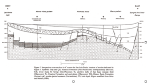
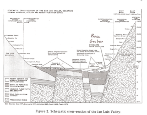
3) Again, authors of all peer-reviewed papers on the geology of the San Luis Basin agree that basin fill consists mainly of upper Oligocene to middle Pleistocene sediments (as much as 5.6 km thick), comprised of mudstones and coarse lithic sandstones and conglomerates, overlying Precambrian bedrock (Chapin and Cather, 1994; Kluth and Schaftenaar, 1994, Brister and Greis, 1994; Brister and McIntosh, 2004)). Their conclusions are based on seismic, gravity, and well data, as well radiometric dating and geologic mapping. None of these geological experts recognize the presence of Mesozoic hydrocarbon source rocks in San Luis Basin sediments. Thus, for example, Kluth and Schaftenaar (1994) conclude that the basin is filled with about 6.4 km (21,000) of mostly Tertiary sediments, Oligocene and younger in age. They also conclude that the angle of the (east) bounding fault of the Baca graben is about 60º, with 45º as an absolute minimum angle.
4) By contrast, a geologist who happens to work for Lexam Explorations, Inc., Thomas Watkins, has written a 7-page report that postulates that Mesozoic source rocks are abundant in the San Luis Basin (Watkins, no date given). These conclusions are justified based on re-interpretation of seismic data in addition to well data acquired in 1992 and 1993. Although this paper has not gone through the accepted scientific peer-review process, it provides the scientific basis for the report prepared by Toronto-based consulting group, Watts, Griiffiths and McQuat (Hoey, et al., 2006) that Lexam is using to justify its drilling program and fund-raising efforts.
Lexam’s (Hoey, et al., 2006) geologic cross-section of the northern San Luis Valley:
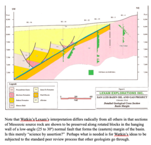
Note that Watkin’s/Lexam’s interpretation differs radically from all others in that sections of Mesozoic source rock are shown to be preserved along rotated blocks in the hanging wall of a low-angle (25 to 30º) normal fault that forms the (eastern) margin of the basin. Is this merely “science by assertion?” Perhaps what is needed is for Watkin’s ideas to be subjected to the standard peer review process that other geologists go through.
II) Regarding very salient fact #II, Lexam’s drilling of two 14,000’ exploratory wells could directly and adversely affect the quality and quantity of groundwater in the San Luis Basin. This groundwater occurs in two major reservoirs. The shallow, unconfined aquifer provides drinking water to our community and most, if not all, of the communities in the San Luis Valley. It also provides water for agriculture. The groundwater utilized for drinking water and irrigation is within 7 feet of the surface in some locations in a highly permeable sand formation. Any surface disturbance or spill due to drilling operations has the potential to impact the groundwater quality adversely. Thus, contamination of this unconfined surface aquifer could mean the loss of our groundwater resource for generations. In addition, it could have very negative impacts on downstream users of the Rio Grande River in New Mexico, Texas, and Mexico, all of which have treaty rights to surface water, which is affected and supplied by the much larger quantity of groundwater in the confined and unconfined aquifers.
Thus, more specific information regarding groundwater flow directions is needed. The interconnection and interaction between surface water (streams and wetlands) and the unconfined and confined aquifers also needs to be evaluated. Specifically, more data is needed on the potential impacts of drilling on each of these interrelated parts of the surface water/groundwater system. Thus, a thorough evaluation of the groundwater system and an Environmental Impact Study (EIS) should be conducted before these test wells are permitted.
This is indeed a special situation, where a federally-owned area set aside for the protection of the area’s ecosystem, has a privately-held mineral right. If this were a typical federal site, the National Environmental Policy Act (NEPA) would require that an EIS be conducted. The COGCC may not have a specific process for conducting an EIS or evaluating a site prior to authorizing drilling. However, before the COGCC issues drilling permits that would potentially damage this incredibly valuable resource, it is essential that EIS and groundwater evaluation be conducted by others so that scientifically-supported data can be provided to the COGC prior to well-permitting.
In conclusion, the two most very salient facts surrounding this issue indicate that 1) the potential of finding a recoverable amount of gas is low, highly speculative, and even doubtful. 2) Groundwater, on the other hand, is arguably the SLV’s most precious resource. It supports our lives and livelihoods. It’s ownership and use is regulated by a complex set of laws involving several basin states as well as Mexico. Thus, it seems common sense that the water rights and surface-owner rights (especially those of a federally-protected Wildlife Refuge) are a much higher priority than a speculative mineral right. Clearly, the protection of this groundwater reservoir should be the highest priority. And the potential contamination (and potential theft by secretive and perhaps illegal tactics) of this vast reservoir of groundwater is an unacceptable risk.
Thus, I join many others in the San Luis Valley in urging you to allow more time for a thorough evaluation of the groundwater system as well as the completion of an EIS before you approve Lexam’s drilling applications. In addition, because the proposed exploratory drilling may be based on “science that fits the policy objective” rather than objective science and because this could constitute a step towards a potentially illegal “water grab,” I suggest that the COGCC also contact the following before issuing any drilling permits:
1) other geological/hydrogeologic experts, such as the geologists referenced here, to determine if Watkin’s report is scientifically credible.
2) an independent, better-business bureau or environmental advocacy agency in order to get an independent assessment of Lexam’s real objectives in this “drill play.”
Finally, and very importantly, 3) a way to discover whether Lexam’s real goal is determine the value and gain control of the groundwater of the San Luis Valley would be to carefully examine the sales and land transfer agreements between AWDI, the Baca Corporation, the Nature Conservancy, and the Baca National Wildlife Refuge. A careful reading of these documents by independent legal council could reveal whether Lexam, or some corporation in partnership with Lexam, could legally acquire the water rights under the BNWR and therefore, in the San Luis Valley.
Time and experience have taught me to “follow the money.” However, my suspicions of a “secret water grab” could be entirely unfounded. In that case, the BNWR, our Valley citizens, and hopefully the COGCC still need to try to mitigate with the potentially very damaging impacts of gas exploration and possibly, production. Thus, if, under pressure from current, industry-friendly political forces, the COGCC chooses to proceed with authorization of the drilling application, I, along with many other local agencies and individuals, request that the following conditions or restrictions be included in the permit:
Off-site disposal of all drilling wastes (liquid and solid), including drilling mud.
Utilize the Best Available Technology for installation of the well to protect all groundwater aquifers, such as concrete casing of the well to full depth.
Conduct groundwater monitoring, including existing water wells surrounding the drill sites and an alarm-well system around each drill site.
Consideration for safety and traffic on public roads.
Of course, in addition to the protection of groundwater, many local groups are concerned about air quality in our nearby community. Based on the prevailing wind direction and the proximity of the mountains immediately to the east, any air discharges could concentrate in the community and air quality would be negatively impacted.
Thank you for considering these concerns. We, the affected citizens of the San Luis Valley, count on you doing the right things to protect the quality of our environment.
Sincerely yours,
Dr. Eric T. Karlstrom
Professor of Physical Geography
California State University, Stanislaus
Member, San Luis Valley Citizen’s Alliance
P.O. Box 54, Crestone, CO 81131
Cc: Senator Ken Salazar
Representative John Salazar
References Cited
Aber, J.S., 2002, San Luis Valley, Colorado, http://academic.emporia.edu/aberjame/field/rocky-mt/zapata.htm
Brister, B.S. and Chapin, C.E., 1994, Sedimentation and tectonics of the Laramide San Juan Sag, Southwestern Colorado, The Mountain Geologist, Vol. 31, No. 1, p. 2-18.
Brister, B.S. and Gries, R.R., 1994, Tertiary stratigraphy and tectonic development of the Alamosa basin (northern San Luis Basin), Rio Grande rift, south-central Colorado. In: Keller, G.R. and Cather, S.M. (eds.), Basins of the Rio Grande Rift: Structure, Stratigraphy, and Tectonic Setting. Geological Society of America Special Paper 291, Boulder, Colorado, p. 39-58.
Brister, S. and McIntosh, W.C., 2004, Identification and correlation of Oligocene
ignimbrites in well bores, Alamosa Basin (northern San Luis Basin), Colorado, by single-crystal laser-function 40A/39A geochronology of well cuttings. New Mexico Bureau of Geology and Mineral Resources, Bulletin 160, p. 281-296.
Chapin, C.E. and Cather, S.M, 1994, Tectonic setting of the axial basins of the northern and central Rio Grande rift. In: Keller, G.R., and Cather, S.M. (eds.), Basins of the Rio Grande Rift: Structure, Stratigraphy, and Tectonic Setting. GSA Special Paper 291, Boulder, CO, p. 5-25.
Hoey, N.P. (of Watts, Griffis, and McQuat), Watkins, T.A., and Parsons, K., 2006, A summary review including a work plan and budget proposal to test oil and gas
prospects on the San Luis Basin Property, Colorado, USA, for Lexam Explorations, Inc.
Keller, G.R. and Cather, S.M., 1994, Basins of the Rio Grande Rift: Structure,
Stratigraphy, and Tectonic Setting, Geological Society of America Special Paper
291, Boulder, Colorado.
Kluth, C.F. and Schaftenaar, C.H., 1994, Depth and geometry of the northern Rio Grande rift in the San Luis Basin, south-central Colorado. In: Keller, G.R. and Cather, S.M. (eds.) Basins of the Rio Grande Rift: Structure, Stratigraphy, and Tectonic Setting. GSA Paper 291, Boulder, Colorado.
Watkins, T.A. (no date given). Geology of the northeastern San Luis Basin, Saguache County, Colorado, 7 pp.
________________________________________________________________________
Water Watch Alliance December 4, 2006
Address, email, website??
Dear Friends,
Many of you may have heard of the possibility of natural gas drilling occurring only one to two miles west of the Baca community on the new Baca National Wildlife Refuge. We are asking for you to help us try and save our spectacular environment and our way of life here in the San Luis Valley. If this sounds overly dramatic, it is not. We need your financial help NOW in order to stop this.
We are calling our group the Water Watch Alliance, since water is really the key to maintaining the quality of the environment and economy in this spectacular, sensitive, and pristine area.
Lexam Explorations, Inc., a Canadian firm, has applied for permits to drill two 14.000’ gas test wells in the Baca Refuge just west of the Baca subdivision. Through recent land transfer agreements, Lexam owns the mineral rights under the Refuge. Drilling the two test wells is considered a wildcat, high risk, and speculative endeavor. But they are willing to gamble $10 million on a potential bonanza if they strike a large reservoir of natural gas in the basin. Once the test drill permits are issued, Lexam does not have to apply for another permit to mine the gas. This makes the issue even more time-sensitive.
There is a precedent for blocking private gas drilling on public lands. Proposed drilling in the Valle Vidal Wilderness in New Mexico was stopped by citizens who stood up in numbers, until state legislation was put into place which permanently protects the area. So we know it is possible to protect this area too. The money we are asking you for would be used for legal assistance, publicity, and other expenses. Many of us volunteers in the Water Watch Alliance have put dozens to hundreds of hours into this effort, as well as our own funds. But to move forward, we need the help of the entire community.
We are currently exploring and implementing several strategies. This is why we need your financial help, as well as your time and ideas, if you are interested in joining us. We think it’s worth the effort. If we sit back and let this happen, our way of life in the San Luis Valley could be permanently diminished. As other Rocky Mountain communities have learned through hard experience, full-scale gas production activities can devastate pristine environments by adding toxic pollutants to air and water (both surface water and groundwater), and negatively impact human communities and wildlife. A small group of Baca residents went to visit the area just south of Silt and Rifle, Colorado, to examine the impacts of Encana’s massive gas production activities on local communities. Of the four in our group, three came back quite ill from their brief (less than 2 hours) exposure to air pollution from the gas drilling, which includes ground level ozone and carcinogenic compounds.
Today, the San Luis Valley may be the last, relatively unspoiled and pristine mountain basin in Colorado. But that could change quickly if Lexam discovers commercially-viable levels of gas or oil in the San Luis Basin. The pollution, noise, environmental degradation, and “boom-town” effects that would accompany full scale gas production would destroy the qualities of pristine beauty and profound silence that originally drew many of us to this special and sacred place.
Please donate what you can. We are doing this for all of us.
Tax-deductible checks can be made to:
The San Luis Valley Ecosystem Council
Attention: Lexam
Thank you so much,
Eric Karlstrom
____________________________________________________________________________
The Water Watch Alliance December 6, 2006
The San Luis Valley Ecosystem Council
P.O. Box 223
Crestone, CO 81131
Dear Friends,
You may have already heard of the possibility of natural gas drilling occurring only a few miles west of the Baca community on the new Baca National Wildlife Refuge. We are asking for your help now to save our spectacular environment and way of life here in the Crestone Baca Community and San Luis Valley.
The volunteer Lexam working group has had several meetings over the last few months to gather information and inform the community and ourselves about the consequences of oil and gas exploration and drilling. We are calling ourselves The Water Watch Alliance (WWA), since water is really the key to maintaining the quality of the environment and economy in this spectacular, sensitive, and pristine area.
This issue is time-sensitive for the following reasons:
Lexam Explorations, Inc., a Canadian firm, has applied for permits to the Colorado Oil and Gas Conservation Commission (COGCC) to drill two 14.000’ gas test wells in the Baca Refuge just west of the Baca subdivision. Through recent land transfer agreements, Lexam owns the mineral rights under the Refuge. Drilling the two test wells is considered a wildcat, high risk, and speculative endeavor. But they are willing to gamble $10 million to reap potentially huge profits if they strike a large reservoir of natural gas. Once the test drill permits are issued, Lexam does not have to apply for another permit to mine gas from those particular wells.
Legal Research needs to occur now regarding a surface agreement that is in place between the Baca National Wildlife Refuge and Lexam that apparently allows Lexam access those mineral rights. We need legal expertise from National Environmental Policy Act (NEPA) lawyers to review this agreement so that pressure can be applied to the U.S. Fish and Wildlife Service to do an Environmental Impact Statement (EIS) or Environmental Assessment (EA) on the proposed drilling.
We are currently exploring and implementing several strategies including mounting letter writing campaigns to political representatives and the COGCC, outreach to media, and research and learning from western slope communities which have been the hardest hit, and finally, outreach to elders in Native American communities.
As other Rocky Mountain communities have learned through hard experience, full-scale gas production activities can devastate pristine environments by adding toxic pollutants to air and water (both surface water and groundwater) and cause many other negative impacts on human communities and wildlife.
Recently, a small group of Baca residents went to visit the area just south of Silt and Rifle, Colorado, to examine the impacts of Encana’s massive gas production activities on local communities. The majority came back ill from their brief (less than 2 hours) exposure to air pollution from the gas drilling, which includes ground level ozone and a suite of carcinogenic compounds.
Today, the San Luis Valley may be the last, relatively unspoiled and pristine mountain basin in Colorado. But that could change dramatically if Lexam discovers commercially-viable levels of gas or oil in the San Luis Basin. The pollution, noise, environmental degradation, and “boom-town” effects that would accompany full scale production could destroy the qualities of pristine beauty and profound silence that originally drew many of us to this special and sacred place.
We cannot just sit back and let this happen. Please donate at this time, using the business rely envelopes that are included. Make your donations payable to:
The San Luis Valley Ecosystem Council, which has agreed to sponsor this mailing and which is a 501c3 non-profit corporation. Your donations are tax deductible. Please put “Lexam Research” in the memo of your check. If you would like to participate in WWA, please contact us.
You are contributing to your own well being. Thank you for your concern.
Sincerely,
The Water Watch Alliance:
David Bright
Christine Canaly (256-4758)
Lisa Cyriaks (256-4140)
Pavita Decorah
Eric Karlstrom
JoAnne Kiser (256-4732)
__________________________________________________________________________
Ron Garcia, Manager 11/13/06
Baca National Wildlife Refuge
Alamosa, Colorado
Dear Mr. Garcia,
The National Environmental Policy Act (NEPA) requires that federal agencies implement certain procedures and supply documentation to the public when significant environmental impacts could result from activities on federal lands such as Lexam’s proposed drilling of two 14,000’ test wells on the Baca National Wildlife Refuge. Specifically, we are requesting all written documentation that is available, including an environmental analysis and the NEPA decision document. If these policies were not implemented and these documents do not yet exist, we would like to see the written documentation explaining why the BNWR is not in compliance with these federal statutes. We would be happy to accept copies of these documents today.
Sincerely yours,
Dr. Eric Karlstrom, representative of
San Luis Valley Citizen’s Alliance (SLVCA)
P.O. Box 54
Crestone, CO 81131
_________________________________________________________________________
November ____, 2006
Brian Macke, Director
Colorado Oil and Gas Conservation Commission
1120 Lincoln Street
Suite 801
Denver, CO 80203
Subject: Lexam Explorations Application for Permit to Drill in the Baca Wildlife Refuge
Dear Mr. Macke,
The __________________ has some concerns regarding the proposed drilling in the Baca Wildlife Refuge. The shallow groundwater aquifer provides drinking water to our community and most, if not all, of the communities in the San Luis Valley. It also provides water for agriculture. The groundwater aquifer utilized for drinking water and irrigation is within 7 feet of the surface in some locations in a highly permeable sand formation. Any surface disturbance or spill due to drilling operations has the potential to impact the groundwater quality. Contamination of groundwater could mean the loss of our groundwater resource for generations. Specific information regarding groundwater flow direction is needed. The interconnection and interaction between the surface and subsurface needs to be evaluated, including the presence of wetlands in the area. We request that a thorough evaluation of the groundwater system and an Environmental Impact Study (EIS) be conducted before these test wells are permitted.
This is a special situation, where a federally-owned area, set aside for the protection of the area’s ecosystem, has a privately-held mineral right. If this were a typical federal site, the National Environmental Policy Act (NEPA) would require that an EIS be conducted. Although the Colorado Oil & Gas Commission (COGCC) may not have a specific process for conducting an EIS or evaluating a site prior to authorizing drilling, this is a unique situation. We are not requesting that the COGCC conduct the EIS or the groundwater evaluation themselves if it is not part of your process, but to allow time for these evaluations to be conducted by others so that scientifically supported data can be provided to the COGC prior to well-permitting.
The potential of finding a recoverable amount of gas is speculative. Groundwater is arguably the SLV’s most precious resource; it supports our lives and livelihoods. When are water rights and surface-owner rights (especially a federally-protected surface) considered a higher priority than a speculative mineral right? The protection of groundwater should be the highest priority. Contamination of groundwater is an unacceptable risk.
We urge you to allow time for a thorough evaluation of the groundwater system and completion of an EIS before approving the drilling applications. If the COGCC chooses to proceed with authorization of the drilling application, we request that the following conditions or restrictions be included in the permit:
Off-site disposal of all drilling wastes (liquid and solid), including drilling mud.
Utilize the Best Available Technology for installation of the well to protect all groundwater aquifers, such as concrete casing of the well to full depth.
Conduct groundwater monitoring, including existing water wells surrounding the drill sites and an alarm-well system around each drill site.
Consideration for safety and traffic on public roads.
In addition to the protection of groundwater, we are also concerned about air quality in our nearby community. Based on the prevailing wind direction and the proximity of the mountains immediately to the east, any air discharges could concentrate in the community and air quality would be negatively impacted.
Thank you for considering our concerns and requests.
___________________________________________________________________________
November 9, 2006:
Best Management Practices Recommendations to Ron*
The San Luis Valley Citizen’s Alliance (SLVCA)
These Guidelines are for the drilling of two 14,000 feet test wells by Lexam Explorations, Inc. Should gas or other valuable minerals be discovered, these guidelines will be held in full force, but an additional set of guidelines will be developed to cover the extraction of discovered gas and all aspects of commercial natural gas production or production of other valuable minerals.
“Responsible Development is a proven way of conducting natural gas development operations, which eliminates or minimizes adverse impacts from natural gas development on public health and the environment, landowners, and natural resources; enhances the value of natural and landowner resources; and reduces conflict between industry, landowners, and the community.”
1) Clustered Development of wells: Clustered development places maximum amount of drilling activity on a minimum number of drilling pads in order to centralize infrastructure and minimize surface disruption and impact to landowners and the natural environment. This results in fewer roads, pipelines and drill pads, reduced landowner conflicts, etc. It is important to maximize the distance between pads used for down-hole drilling and maximize the use of directional drilling, based on the best available technology.
2) Recognition of sensitive areas near waterways, wildlife areas or migratory corridors, wetlands or floodplains. Consideration for safety, noise, traffic, and visual impacts should be taken into consideration.
3) Spiritual and historical preservation- Written notification to SLVCA of any archaeological and sacred sites found on or around the proposed drilling area during exploration, production and cleanup phases of operation. Also, full disclosure to consulting experts in this field and interested Native American tribes and agencies.
4) Create “continuity of development plan” with BNWR, Lexam, and SLVCA.
a. Identify areas where drilling will take place before drilling begins in order to create a development plan utilizing Clustered Development guidelines so that pads can be used during both exploratory and development operations; Work with all industry operators to achieve a plan that has longevity and continuity;
b. Locate vehicle transportation corridors prior to the commencement of drilling operations;
c. Locate production corridors for gas gathering and transportation pipelines as well as water and or fluid disposal pipelines, placing as many lines as possible in the same trench or corridor in order to minimize area impact.
d. Written notice provided to BNWR and Crestone/Baca community of all new technologies being used, their components and material that make up and fuel such technologies.
5) Provide Wildlife Refuge (BNWR) and community with a generalized semi-annual drilling plan.
a. Industry cooperation in producing periodic newsletter for area residents.
b. Use of pit-less (closed loop) drilling systems to eliminate drilling mud, fracing flow back and petrochemical and produced water waste pits and their associated odors; If pits must be used, they will be lined with plastic, fenced and netted sufficient to protect domestic livestock and wildlife;
c. Water used for drilling and fracture treatment to well sites should be
transported in pipelines to a central facility where feasible, rather than hauled by trucks. Wastewater should be transported to a permitted water disposal injection wells. No wastewater will be stored other than in temporary storage tanks. No evaporation pits will be used.
d. Place multiple pipelines (water and gathering) in the same trench when practical.
e. Erosion control to meet all Storm Water regulations.
f. Use county-approved plan to control invasive, toxic weeds.
g. Use heavy-duty flow-back units that reduce odors and the need for flaring by 85-95%.
h. Use odor control and combustion devices on industry equipment to reduce VOCs and odors.
i. Monitor and reduce “fugitive emissions” (i.e., emission of ozone and other smog-related compounds from leaking tanks, pipes, etc.)
j. Use barriers and berms around well pads to reduce noise, light, and visual impacts of drilling.
k. Noise levels not to exceed COGCC day and nighttime standards.
l. Use fully enclosed compressor stations equipped with noise reduction equipment to minimize noise.
m. Set-backs from inhabited dwellings of 500 feet whenever possible;
n. Removal of petrochemical waste, pond liners and any surface contamination after drilling is completed;
o. No horns, bells, or other noise-making devices to delineate shift changes;
p. Telemetry on all producing wells to reduce truck traffic checking wells and increase safety;
q. Water quality testing of all domestic wells within 1/2 mile of pad before drilling begins;
r. Water quantity testing available when requested by the landowner, taking into consideration seasonal flow fluctuations;
s. Monthly testing of domestic water wells that are 1/2 mile down gradient of drilling operations;
t. Quarterly testing of all domestic water wells within 100 feet of a drilling pad for the first three years of operation and as necessary, but at least annually, throughout the productive life of the well;
u. Random community irrigation water testing throughout the area and in specific locations where there is cause for concern.
v. Graveled pads to reduce mud and the resulting dust on roads;
w. Use of smaller, newer rigs to reduce noise and surface impacts;
x. Compliance with the Colorado Water Quality Control Commission’s storm water runoff regulations;
y. All hydraulic fracturing operations (“fracing”) shall be conducted with “green frac” methods, utilizing only sand and water as fracing materials or other “green frac” materials agreed upon between the community and industry. The use of diesel fuel, petroleum products or chemicals containing aromatic compounds such as benzene and toluene or other compounds such as 2 BE, will not be permitted as a part of the fracing process.
z. Written notification and listing to BNWR and SLVCA of any other mine-able materials found on site during exploration, production, and cleanup phases of operation that are not components of oil and gas.
Please see the appendix section of this document for the definition of a “green frac.”
6) Monitoring area air and water quality for impacts from drilling activities, including:
a. Baseline monitoring of existing water and air quality to county health officials, BNWR, POA, and SLVCA (or its future equivalent).
b. Written reports provided to BNWR, the POA, the SLVCA of total dissolved solids and contaminants from wells, fracing and cleanup in which the written reports will disclose any pollutants harmful to area residents and plants and animals on the Wildlife Refuge.
Surface spills of petrochemicals and hazardous wastes associated with drilling
c. Contamination of domestic water wells and ground water
d. Ozone-causing VOC emissions from condensate tanks and compressor stations.
e. Ground-level ozone impacts to vegetation and crop health and viability as well as community health concerns
f. Leaching of hazardous chemicals into soils and groundwater from well pad spills
g. Wildlife disruption and wildlife habitat destruction
h. PM-10 (airborne particulate matter measuring 10 microns or larger) impacts on crops and human health. To mitigate these impacts, the industry operators agree to participate in appropriate new and ongoing monitoring activities. Parameters selected will be recommended by the state agencies that oversee specific impacted areas, including:
· Colorado Air Quality Control Commission
· Colorado Water Quality Control Commission
· Colorado Division of Wildlife
· Local county weed programs
· Bureau of Land Management
· Saguache County
Working in conjunction with these agencies, monitoring will document changing conditions from drilling as well as other activities, and plans for mitigation of adverse impacts that result from natural gas drilling will be developed and implemented. Results of monitoring activities will be shared with appropriate agencies, as well as Saguache County, for incorporation into ongoing monitoring programs.
i. We, the BNWR, the POA, and the SLVCA (or its equivalent), reserve the right to have our own team of experts monitor, examine, evaluate, research, and obtain pertinent information and material of the site and surrounding areas in order to determine what is hazardous to our Wildlife Refuge, community, and aquifer and these reports will be made public.
7) Plugging and Abandonment of Gas Wells. With the typical producing life of a gas well between 10 and 20 years, it is recognized that the industry operator that drills the well will likely not be the operator responsible for plugging and abandonment. It is, however, understood that when a gas well is no longer capable of producing economic quantities of gas, and re-stimulation does not produce additional gas flow, the well will be plugged and abandoned, as stipulated in the COGCC regulations.
8) Control of Noxious Weeds via collaboration with Baca National Wildlife Refuge. Noxious weed invasion is a significant threat to agriculture and wildlife habitat, rivaling urban sprawl in acres of habitat lost in many rural counties. Studies document that the number one way weeds are spread is from seeds transported on truck tires. Gas industry developers will develop and utilize a program in collaboration with the Wildlife Refuge and Saguache County to actively
control the spread of noxious weeds. In conjunction with local governments, the gas industry must be accountable to mitigate any spread of noxious weeds that may result from drilling operations.
In addition to the County’s weed program, this plan will take into consideration the protection of the area’s organic agricultural activities. Management of noxious weeds will apply to all areas disturbed by drilling operations, including but not limited to existing roadways and borrow pits, new roads, pipeline cuts, and well pads.
Reseeding will be done with native high desert plants appropriate for the area.
9) Interim & Final Reclamation. When drilling operations have been completed, COGCC rules require “the surface of the land to be restored as nearly as practicable to its condition at the commencement of drilling operations.” Two types of reclamation are delineated – interim and final. COGCC rules state “interim reclamation shall occur no later than three (3) months on crop land or twelve (12) months on non-crop land after such operations, unless the Director extends the time period because of conditions outside the control of the operator. This reclamation applies to disturbed areas affected by drilling except what is reasonably needed for production operations. Final reclamation takes place when a well is no longer producing and has been plugged for abandonment. At that time, all equipment must be removed and the land re-contoured and reseeded as near to the original condition as possible.
In the Wildlife Refuge, a third type of reclamation will be utilized. Within 30 days of re-contouring and re-grading a pad or any portion of a pipeline corridor, the operator will loosen all surface soils to a depth of 8 inches and seed that area as per recommendations of the Baca National Wildlife Refuge, unless the season of the year makes such activities undesirable, in which case re-seeding will take place as soon as weather and seasonable conditions are favorable. When seed, at a minimum of 50 seeds per square foot, is applied to freshly disturbed soil with an “organ grinder” or “whirly bird” seeder before crusting and compaction can take place, the success of re-vegetation is very high. This method preserves the soil’s health, minimizes dust and is an inexpensive application, even if the sites have additional disturbance in the future. Operators will work closely with landowners on all reclamation matters, including seeding mixture preferences, re-contouring and loosening of compacted soils, which impede the success of re-vegetation. These guidelines will apply to well pads, pipeline corridors, compressor station locations, and any other construction associated with gas development
10) Community Health and Safety
Industrial activities around subdivisions, and within city limits pose a variety of dangers to residents.
Emergency Preparedness measures include:
a. Participation in the county’s emergency response plan for gas development through active participation in the Saguache County or SLVCA Local Emergency Planning Committee.
b. Education and training of all employees and subcontractors regarding emergency plan information and their ability to respond to emergency situations involving spills, leaks, human injury, fire and explosions.
Roads and Traffic
a. Work with Saguache County to review and define appropriate industry speed limits and signs and the county’s Road & Bridge Department to obtain all permits, post bonds, and coordinate addressing designated routes, inadequate infrastructure and dangerous areas by creating:
a plan for traffic management that takes into consideration blind corners and hills, narrow roads and bridges, and dangerous intersections. In addition, school bus routes will be avoided during designated hours by industry traffic during drilling and completion operations. If a school bus route cannot be avoided during drilling and completion operations, the areas near bus stops will be monitored by flagmen or security personnel during designated hours at industry’s expense to protect children loading and unloading from buses.
a plan for ongoing dust mitigation using environmentally responsible substances.
b. Provide cost mitigation to the towns and the county for road upgrades and road damage.
c. The operator and all its subcontractors agree to abide by all traffic rules and speed limits.
Water Issues
A plan for avoiding disruption to irrigation, including community and individual systems, will be part of all gas development operations. When drilling operations – including roads, pads and pipelines – cross or in any way impact established community irrigation ditch systems, landowners and industry will include the applicable ditch company in the decision making process and obtain approval for mitigation of any impacts. Considerations include: 1) prevention and repair of any disruption to the flow of irrigation water and irrigation runoff caused by roads and pipelines that cross ditches, and; 2) the possibility of piping water in areas where it is at risk of contamination.
Limitations on new industries and industry activities in Crestone/Baca and BNWR
There will be no new gas-related industries or industry activities within Crestone/Baca and BNWR boundaries.
11) Addressing Financial Impacts
The industry agrees to participate as a good neighbor by helping to financially address negative impacts. Priority areas to consider include:
a. Mitigation of damage to infrastructure, including roads, bridges and irrigation systems caused by drilling activities;
b. Mitigation of socio-economic impacts to schools, hospitals, emergency services, law enforcement and human service agencies;
c. Participate with the county and municipalities on road and intersection improvements and signage.
12) Interagency Team
As soon as possible, assemble an interagency team and commit sufficient funding to enable effective implementation of a system to gather baseline data and to monitor the affects of drilling and development on surface and ground water, air quality, vegetation, and selected wildlife species. Also, the use, disposal, and movement of all listed hazardous chemicals should be tracked, recorded and reported to the BLM.
13) Monitor wells
Within three years determine the effectiveness and longevity of cementing a well bore after it is abandoned.
14) Establish a reclamation guarantee system
As soon as possible, implement a reclamation guarantee system that follows the well regardless of ownership to ensure that sufficient funding is available to plug and abandon the well, to re-contour the disturbed surface to as near its original condition as possible according to state law, and to establish viable populations of native plants. Where industry pays a mill levy to the state based upon production, provisions must be made to ensure that these funds remain available for the entire productive life of the fields for reclamation of drilling pad and road impact areas, including abandoned wells when needed.
15) Monitor, inspect and enforce lease terms
Make timely inspections and enforcement of all lease terms a high priority. Companies should not be given years in which to come into compliance with lease terms.
16) Bonding
a. Make sure the amount posted as bond is sufficient to cover the kinds of clean-up costs that are typically associated with gas mining operations.
b. Bonding reclamation facts, stipulations, and the processes they enact or impede.
17) Lexam costs
a. Any research reports, flow sheets, or material Lexam provides BNRW, POA, or SLVCA, they will incur the costs of these.
b. Written lists of Lexam’s protocol of weekly cleanup to BNWR and SLVCA (or its future equivalent) and issued as public record to be posted.
18) Full Disclosure
Full disclosure of any buy-outs or leases to other companies or corporations while exploration is in effect and in the event product is found, including in the cleanup phase.
Written notice to BNWR, the POA, and SLVCA (or its equivalent) of any Lexam employees cited for intoxication or drug abuse while on duty.
19) Open door policy
We (the SLVCA or its equivalent) reserve the right to negotiate and revise during and after exploration, production, and cleanup with Lexam officials and the BNWR presented in written format the concerns and guidelines we as a community wish to discuss.
20) NEPA, EIS, or ES Studies on BNWR
It is important that baseline data for the BNWR be established through traditional avenues of conducting NEPA, EIS, or ES studies. We encourage the BNWR to get have these studies, either through government funding or by Lexam, if possible.
References:
1. The Rifle, Silt, New Castle Community Development Plan, January 1, 2006 A Project of the Grand Valley Citizens’ Alliance, and
2. Management Guidelines for Oil & Gas Development (August 4, 2005), Colorado Mule Deer Assoc.
3. Oil and Gas at Your Door? A Landowner’s Guide to Oil and Gas Development, 2nd Edition, Oil and Gas Accountability Project (OGAP), 2005
_________________________________________________________________________
October 16, 2006: Lexam Talking Points
I. History of Lexam
1) Lexam Explorations Inc. (Lexam) is a Toronto Venture Exchange (TSX-V), Toronto-based, junior exploration company. It incorporated in 1983. It changed it’s name from Challenger Gold to Lexam when it went public.
2) Lexam’s management team, mainly consisting of former Goldcorp Inc. officers, oversaw development of Red Lake Mine, Canada’s largest gold mine.
3) Lexam purchased 50% of the hard mineral rights from Baca Minerals in 1987.
4) Lexam later purchased the other 50% of the oil and gas rights on the Luis Maria Baca Grant No. 4 from Newhall Land and Farming Company.
5) Lexam acquired the additional 25% of the oil and gas rights from the Baca Corporation in 1996, purchased from Gary Boyce for $1 million.
6) Lexam aquired surface access and use by fee simple ownership and a Surface Use Agreement with American Water Development, Inc. (AWDI) in 1992- purchased for $1 million. This Surface Use Agreement is a 20-year paid-up lease that is binding on surface owners who may be successors in ownership to AWDI. This agreement can be extended if there is production on the property.
7) The remaining 25% of oil and gas rights is owned by ConocoPhillips. But there is currently no agreement between Lexam and ConocoPhillips.
8) Lexam also owns various interests in varying percentages of the hard mineral and oil and gas rights on land to the north and west of the Grant.
9) The surface is currently owned by the Nature Conservancy- with intent to convey ownership of the surface to the Federal Government (USFWS and NPS) eventually.
10) To date, there is no indication the Federal Government wants to acquire Lexam’s mineral rights.
11) Drilling of the recommended wells on the Crestone East Prospect is considered high risk, but there is significant potential of discovering large amounts of gas and oil in the San Luis Basin. This depends upon: 1) presence of favorable source rock and sealed traps. These are the risk factors. Actual presence of the various factors requires drilling.
12) Lexam is applying for permits to drill 2 14,000 test wells in the deepest part of the basin that has never been drilled.
II. History of the “Crestone Prospect”
1. 1992 and 1993- Challenger Gold drills many exploratory wells and gets strong shows of live oil encountered in 27 drillholes. Cretaceous Mancos Shale, Dakota Group and Jurassic Morrison Fm rocks were identified in outcrop and 17 shallow drillholes. Of these, Mancos Shale is thought to be an excellent source rock and Dakota SS is thought to be sufficiently porous (15-21%).
2. 1995- Lexam drilled the Baca #1 and Baca #2 wells and confirmed Cretaceous section on the Deadman Creek block. The strongest shows of oil were in Baca #2 well at 6,620 feet in Tertiary Sante Fe Fm., Mancos Shale and Precambrian gneiss.
3. 1996- Lexam gained 20 miles of seismic data and 221 gravity data points, which strongly support the presence of a thick Cretaceous to Jurassic section in the Baca Graben. Integrating this seismic data with previous seismic data- delineated a large structural closure (Crestone Prospect) at 7000 to 12,000 feet- both trap types are present.
4. 1998- SONAT acquired 31 miles of 2D seismic data over the Crestone Prospect. This confirms closure of Crestone structure.
5. 1999- SONAT relinquished its option agreement on seismic data with Lexam in 1999* (why?).
6. 1999-2000. Lexam acquired and reinterpreted seismic line CF-8402- which suggest gas in Tertiary seds above the Crestone Prospect.
7. 2002-2004. Petro-Hunt acquired, processed and interpreted another 60 miles of 2D seismic data in 2004 and bought and reinterpreted another 50 miles of Chevron 2D seismic data- Petro-Hunt relinquished this option in Dec. 2004.
8) 2005- Lexam purchased this seismic data for $419,000 in March 2005*. Closure is better defined for Crestone East block than the Crestone West block.
8. Today- Primary targets are Crestone East (4060 acres) and Crestone West (6,945 acres) prospects, in NW quadrant of the property. In addition, at Pole Creek (SE part of Baca Land Grant), a shallow 1.3 acre oil target is present in land overseen by the NPS.
* You have to wonder why Sonat and Petro-Hunt sold their seismic data if the results were so promising.
III. Geological context of the San Luis Basin
1. The Baca Grant property (100,000 acres) is part of the San Luis Basin, a graben that extends north of the Rio Grande Rift in New Mexico. The basin includes two half grabens, the western Monte Vista Graben and the eastern Baca Graben, separated by the Alamosa Horst. Depth to Precambrian basement rocks in the Baca Graben is estimated at about 14,000 feet. Sediments and sedimentary rocks within the Baca Graben include, from top down, the Pliocene to Pleistocene Alamosa Formation and the Miocene Sante Fe Formation, as well as possibly Mesozoic sedimentary rocks (Mancos Shale, Dakota Sandstone, and Morrison Formation) and Permo-Pennsylvanian sedimentary rocks of the Sangre de Cristo Fm. The Mesozoic sediments, if present, would provide the “source rock” for gas and oil. There are two small outcrops of Mesozoic sediments near the eastern margin of the basin.
2. Until recently, it was believed there were no Mesozoic sediments in the basin. However, 27 of 42 shallow exploration drillholes drilled by Challenger Gold Inc. in 1992 and 1993 encountered oil in “fractured Precambrian rocks and Mesozoic sediments.” 17 of these hit Mesozoic sediments that occur as rotated fault blocks in the hanging wall of the basin-bounding detachment fault. Geological consultants from Toronto (WGM) believe that the seismic character of basin rocks are “remarkably similar” to that of the San Juan Sag to the west (where Mancos-Dakota-Morrison are present) and the Raton basin to the east.
3) WGM consultants from Toronto* believe that the Baca Graben contains Mesozoic rocks about 3000 feet thick at depths of 7000 to 17,000 feet. Two types of structural traps have been mapped seismically. These are closed structure anticlines and rotated fault blocks close to the margin of the basin. WGM note that all basins surrounding the San Luis Basin with Cretaceous rocks at depth (over 8000 feet) have significant oil and gas accumulations. (The San Juan, D-J, Raton, and Piceance Basins)
The San Juan Basin, has produced over 25 trillion cubic feet of gas. Lexam hopes that over 100 and up to 550 square miles of the Crestone sub-basin contains a 2000 to 3000 ft. thick package of Cretaceous rocks at depths of 7000 to 17,000 feet.
* You have to wonder why Lexam did not use local consultants….. Is this reason for suspicion?
IV. Primary risk factors of the project for Lexam
1) Presence or absence of favorable reservoir rock is not known.
2) do the interpreted structures (anticline and ) constitute “sealed traps” that would hold the gas/oil?
V. Peggy Utresch- of Rifle, Silt, New Castle: Recommendations
1) Oil and gas is the single richest industry in the world. You can’t sue them. All the laws are in their favor. Therefore, we can’t stop the drilling of these test wells.
2) There is very little inspection and oversight, therefore we need to force accountability.
3) Need to try to establish guidelines ensuring:
a) cluster development, directional drilling,
b) continuity of development and organized development,
c) best management practices, such as cluster placement of pipelines, designated truck routes, noise and light mitigation, removal of waste water, combustion equipment to burn up emissions, dust mitigation, use of green fracing fluids,
d) sharing drilling plans with community,
e) allowing monitoring of activities, (get copies of rules and regulations),
f) control noxious weeds,
g) develop plan for community health and safety- develop emergency response plan
h) community education- re: roads and traffic issues, water issues, financial impacts, etc.
i) create community board
___________________________________________________________________________
September 5, 2007:
Mike Blenden
U.S. Fish & Wildlife Service
Baca National Wildlife Refuge
Alamosa/Monte Vista National Wildlife Refuge Complex
9383 El Rancho Lane,
Alamosa, CO 81101
Email: mike_blenden@fws.gov
Comments and Concerns Re: proposed exploratory gas-well drilling by Canadian firm, Lexam Explorations, Inc. on Baca National Wildlife Refuge
At a recent meeting with our Crestone/Baca community (8/17/07), the USFWS initiated an EA/scoping phase of the NEPA process, requesting that local citizens write-in our concerns re: the proposed drilling of two 14,000’ gas test wells by a Canadian corporation, Lexam Explorations, Inc., on the BNWR. We of Water Watch Alliance (WWA, formerly San Luis Valley Citizen’s Alliance) and I as a citizen of the Baca have many concerns regarding the adverse impacts of Lexam’s proposed drilling on sensitive wetlands of the Wildlife Refuge within 1.5 miles of the Baca community. It is our (WWA) opinion that there are numerous reasons that gas and oil exploratory drilling on the Baca Refuge constitutes an “incompatible use” with that of protecting and preserving fish and wildlife habitats as well as the health and viability of human communities and agricultural operations in the San Luis Valley (SLV). In addition, “downstream” communities in New Mexico, Texas, and Mexico, located in the lower portions of the Rio Grande drainage basin, may also be adversely affected by contamination of surface water from the drilling project. The rights of these downstream users are protected by the Rio Grande Compact. We conclude that: 1) many of the inevitable damages caused by gas exploration drilling in this sensitive area cannot be mitigated and therefore should not be allowed, and 2) due to directives from Washington, D.C., the USFWS is out of compliance with many of the federal regulations it is bound by law to follow and enforce.
It is mandated by law that the BFWR conduct a full-blown NEPA process. Even so, the BNWR announced last fall that it was not required to conduct a NEPA process. Today, it is conducting this process, but only in response to a lawsuit filed by our SLVEC/WWA lawyers. The BNWR is now conducting an Environmental Assessment, which suffices as the short version to fulfill legal requirements when the proposed activity is found to cause no significant impacts. However, given the well-documented, adverse impacts of gas drilling elsewhere in Colorado and the West (OGAP, 2005) and given the extremely sensitive nature of wetland ecosystems and aquifers on and under the Baca Wildlife Refuge, we of WWA believe that the USFWS is legally and morally obligated to conduct a full-blown EIS (Environmental Impact Statement) as well as complete their own Management Plan before allowing any drilling to occur on the Refuge. By conducting a full-scale Management Plan, the BNWR will be able to establish base-line data on air quality, water quality, and the ecosystem itself, including delineation of sensitive species requirements, etc. We would hope these data would be shared with local and state health officials, the POA, Saguache County officials, etc. before any exploratory drilling is allowed.
Our group of concerned citizen’s chose to call ourselves the Water Watch Alliance because it became clear to us that the gigantic reservoir of water stored in aquifers beneath the San Luis Valley is a priceless resource both now and in the future. It is our goal to protect this resource against potential long-term contamination by large-scale gas/oil operations. We believe that an honest and adequate EIS process will indicate that drilling should not occur on the BNWR. We should be seeking federal legislation to insure that the SLV remains protected in perpetuity as a “No-Go Zone,” as the Valle Vidal and Otero Mesa of New Mexico have now been designated. Whereas the NEPA process permits federal agencies to use Environmental Assessment’s alone when there are no “unique and exceptional circumstances” and “no significant impacts,” we feel that drilling two 14,000’ gas wells through sensitive wetlands and through a series of priceless aquifers on the newly-created BNWR would certainly have significant, adverse impacts and thus, this certainly qualifies as a “unique and exceptional circumstance.”
Lexam Explorations, Inc., which owns 75% of the mineral rights, is a small Canadian company that has never operated an oil or gas well. They will use subcontractors to carry out their drilling; they don’t intend to operate anything. The remaining 25% of the mineral rights are owned by Conoco-Phillips. If Lexam “strikes it rich” and finds a “tcf” (trillion cubic feet) of natural gas, as they hope, their $20 million investment could provide a windfall financial profit for their 2200 shareholders of between $1 billion and $18 billion. Lexam would then immediately sell out to major oil companies such as Conoco-Phillips, which would then proceed to turn the SLV into a toxic, industrial park. I have visited the gas fields south of Silt, Colorado and talked with local property owners there whose lives have become a prolonged nightmare. People’s health, quality of life, and property values are severely and adversely impacted. In addition, it is now well understood that burning fossil fuels contributes to global climate change. One estimate is that the burning of a “tcf” of natural gas would produce about 150 million tons of carbon dioxide, a greenhouse gas. In Europe, production of this amount of CO2 would be taxed at the rate of nearly $2 billion.
William Blake’s image of “Dark Satanic Mills” dotting the 19th century English countryside might then be an apt description of what our own San Luis Valley could look like as an industrial gas field. Meanwhile, the collective benefit to the nation of a successful gas play here would be to obtain sufficient natural gas to supply the US for perhaps a couple weeks only. And the equivalent amount of energy can now be much less harmfully produced using green energy, including solar, wind, and geothermal energy, which, ironically, are very abundant in the SLV.
Adverse impacts that accompany gas and oil drilling:
1) Pollution and degradation of surface water (wetlands) and subsurface water in the unconfined and confined aquifers. Much of the BNWR consists of seasonal wetlands, which are among the most sensitive and important ecosystems in terms of their importance for supporting a large variety of species. Underneath the BNWR is 14,000’ to 15,000’ of sediments overlying Precambrian bedrock. An impermeable layer of clay, 10 to 80’ thick separates the surface (unconfined) from the subsurface (confined) aquifers. However, there are probably as many as 30 distinct aquifers contained within the confined aquifer (Dr. James McCalpin, pers. comm., 2007). Water pressure increases as you descend in the aquifer, therefore (polluted?) water will tend to rise (and mix) through the aquitards and aquifers. In the unconfined aquifer, water table is quite shallow (about 12’ or less) and hence, any addition of pollutants will likely contaminate surface water essential to a wide variety of human and non-human users, both in the near-term and in the future. This relatively shallow unconfined aquifer provides drinking water to our Baca community and most other SLV communities. It also provides the water needed for fish and wildlife, including over 70 species of rare plants and animals, agriculture in the San Luis Valley, and water usage throughout the Rio Grande basin.
There are currently about 7000 wells in the SLV, of which about 1800 are “deep wells” that penetrate the confined aquifer. There is a significant danger of contaminants from the Lexam drilling operation leaking and irrevocably polluting the San Luis Valley aquifers. If the drillers encounter the Dakota Sandstone, a “reservoir rock” that they hope to find, they will in probably use hydraulic fracturing fluids, which can be highly toxic. This poses a threat to the whole Rio Grande region’s water supply and wildlife for future generations. The state of Colorado, which technically owns most of the water, has recently imposed a moratorium on drilling in the confined aquifer. Why is Lexam Explorations, Inc. exempt from this moratorium? Given the magnitude of adverse impacts of the drilling and the potential future value of water in the aquifer (probably many billions of dollars), exploratory gas drilling is an “incompatible use” with the Wildlife Refuge.
Chemical contamination of groundwater: Dr. Theo Colborn has analyzed the chemical compounds involved in the gas well drilling process by studying Material Safety Data Sheets. Of particular concern is the process of hydraulic fracturing which utilizes a suite of especially dangerous chemicals. Such fracturing operations may require up to a million gallons of fluid per well (Gwen Eifle, OGAP, pers. communication, 2007). Colborn determined that of the 245 chemicals commonly used in drilling, 91% have adverse health effects and there is no information on the other 9%. Of the 91%, 35% are endocrine disrupters for people and wildlife. Some of the most toxic chemicals include BTEX (benzene, tolumene, ethylbenzene and xylene) which are carcinogenic, methane, diesel fuel, hydrogen sulfide, heavy metals, VOCs (volatile organic compounds), formaldehyde and PAHs (Colborn, 1997). On viewing the list of chemicals used, Professor Clay Bridgford, an ex-military man in Crestone, referred to this suite of chemicals as “a laundry list for chemical warfare.” Many of these chemicals have been found in contaminated wells and in grab samples for air quality near gas wells in Colorado and elsewhere in the west (OGAP, 2005).
According to OGAP’s Gwen Lachelt (pers. comm., 2007), due to the current industry-friendly administration, every chemical used is considered propriety by the gas and oil drilling industry and this industry is exempt from following the Clean Water Act and other laws that limit and regulate use of toxic chemicals in the U.S. Drillers also use propolene glycol (an antifreeze) on well pads. When ingested, this chemical is fatal for animals. Hence, pad areas always need to be fenced. However, in practice, they typically are not fenced (OGAP, 2005).
Even closed-loop systems still utilize open, evaporation pits, which often contaminate surface water, poison creatures, and add toxic pollutants to the air.
Inadequacy of concrete well casing: The COGCC issued a permit to Lexam specifying that they only need to use double concrete casing in the well for the upper 3500’ of 14,000’ wells. Clearly, there is great potential for contamination of the confined aquifer if the well hits gas and oil and if the casing leaks in the future. . It is well-known that cement casings lose their integrity over time and can become a source of groundwater contamination for decades and centuries (OGAP, 2005). It is also commonly known that one quart of oil can contaminate up to 250,000 gallons of water. Thus, double concrete casing should extend the entire depth of any well.
Needs of future generations: Future generations of humans and other organisms will depend on the quality and quantity of water in the SLV aquifers. A recent study on global warming concluded that by the year 2050, Colorado residents will have to subsist on 30% less water than present. Contamination of the water supply, then, could have disastrous consequences. Two individuals, Canadian Maurice Strong (AWDI) and local Colorado-resident, Gary Boyce (the Baca Corporation), tried, unsuccessfully, to make billions by exporting water from the SLV to the Denver area. So we can speculate that the value of the water is potentially as great or possibly much greater than that of any oil or gas that may be present. Clearly, more scientific studies are required to determine the potential value of the SLV aquifers as well as to determine how best to protect the quality and quantity of the aquifers.
Water from the Rio Grande River is allocated to three states (Colorado, New Mexico, and Texas) and Mexico and is regulated by the Rio Grande Compact. Potential degradation of water in the SLV aquifers could affect the quality of surface water available to downstream users in these areas in the future. We hope that the Rio Grande Water Conservation District becomes more involved in this issue to help protect water quality and quantity for farmers and downstream users.
Solution: A moratorium on drilling. Because access to fresh potable water in the semi-arid West will probably increase in the future, the Governor of New Mexico has recently imposed a moratorium on gas and oil drilling on the Otero Mesa until such scientific studies are complete. We suggest that our governor and/or our federal representatives do the same in this region.
2) Air pollution: Chemicals used in natural gas development are dangerous to the health of living creatures (animals, plants and humans) who happen to live near the drilling operations. Emissions from drilling pads emit carcinogenic toxic chemicals into surrounding public lands and communities. Ground level ozone causes degenerative health problems for humans, wildlife, plants and agricultural crops. It is the #1 cause of asthma. Because ground-level ozone is produced at every gas well pad, each well needs a special permit to exceed air quality standards required by the state and U.S. government. In addition, after gas comes to the surface, a dehydrator is used to separate the gas from the condensate, which includes a complex of volatile carcinogens, called BTEX, which includes ethyl benzene, xylene, and tolumine. In addition, PM-10 (airborne particulate matter less than 10 microns in diameter) has serious negative impacts on crops and human health. In order to monitor air quality in the BNFWR, it will be necessary to coordinate activities with the following organizations: Colorado Air Quality Control Commission, Colorado Water Quality Control Commission, Colorado Division of Wildlife, Local county weed programs, Bureau of Land Management, and Saguache County. It will also be necessary to conduct preliminary baseline studies on present air quality.
3) Health Concerns: Based on analysis of data in the Chemicals Used in Natural Gas Development Spreadsheets, Dr. Theo Colborn found that of the chemicals used, 49% can cause skin/sensory organ toxicity, 47% can cause respiratory problems, 47% are neurotoxins, 43% are gastro-intestinal/liver toxicants, 38% are kidney toxicants, 33% are carcinogenic, 29% are cardio/vascular/blood toxicants, 27% are immune system toxicants, 25% are developmental toxicants, and 13% are endocrine disruptors. In addition, of the chemicals on the list, 20% are biocide products that kill all life. Of the chemicals that are soluble in water (13%), 72% are neurotoxicants, 61% are gastro-intestinal/liver toxicants, 61% are reproductive toxicants, 61% are skin and sensory organ toxicants, 56% are respiratory toxicants, 50% are kidney toxicants, 39% are cardiovascular toxicants, 28% are endocrine disruptors, and 22% are wildlife toxicants. Furthermore, And furthermore, of the chemicals used in natural gas drilling that vaporize, 66% are neurotoxicants, 60% are gastro-intestinal/liver toxicants, 52% are respiratory toxicants, 45% are kidney toxicants, 43% are reproductive toxicants, 37% are cardiovascular/blood toxicants, 33% are carcinogens, 27% are immuno-toxicants, 14% are endocrine disruptors, and 4% are wildlife toxicants.
4) Impacts upon wildlife: Rare flora and fauna in the San Luis Valley, some found nowhere else in the world, include, the Great Sand Dunes tiger beetle, the giant sand treader cricket, the Rio Grande cutthroat trout, the southwestern willow flycatcher, and the slender spiderflower. Other species found in the area include the bald eagle, sandhill crane, pronghorn antelope, elk, mule deer, bighorn sheep, mountain goats, mountain lion and black bear.
5) Noise, light, and dust pollution: The proposed drilling, located about 1.5 to 2 miles west of the Baca residential community, will produce inevitable noise, light, and dust pollution which will degrade the quality of life for members of the Baca community as well as the habitats of fish and wildlife on the Refuge. In addition, heavy truck traffic associated with various aspects of the operation will significantly increase noise and dust. Compressor stations, if built, produce noise as loud as a jet airliner “24-7” (24 hours a day, 7 days a week. Crestone/Baca includes many spiritual groups and individuals who have moved here because of the pristine beauty of nature and the awesome and profound silence that the area affords. These spiritual groups will be adversely impacted by the drilling operations, in particular.
6) Damage to local roads due to use of heavy vehicles: We can expect that heavy traffic by heavy vehicles will result in damage to local roads and the increase of traffic accidents. Will Lexam pay for the damage their operation causes to existing infrastructure?
7) Infrastructure requirements: There is currently no infrastructure in the SLV that would support gas production. Building such an infrastructure would require construction of gas pipelines, gas compressors, building of innumerable gas well pads, building extra roads, etc. The synergistic effects of these kinds of operations would significantly degrade the pristine quality and quality of life in the San Luis Valley for many residents. Oil spills, truck crashes and highway deaths resulting from those crashes would be highly likely.
8) Boom-town effects: If Lexam strikes gas, we can expect that a suite of highly disruptive “boom-town effects” would accompany the gas boom. Other communities which have been subjected to this process have experienced varying degrees of chaos, social upheaval, negative impacts on schools, emergency services, crime rates, etc. And typically, after gas companies create problems, the local tax payers have pay the cost of the damages, road repair, etc. This pattern repeats in many ways, with local communities paying for extra schools, roads, etc. that industry needs in order to function. Meanwhile, what percentageof the profits are shared with local counties? Often, little to none.
9) Damage to local cultural, spiritual and native American values: The NEPA process requires that the USFWS try to understand the cultural values of the Crestone/Baca community. Our community is comprised of numerous communities and individuals committed to the preservation of pristine nature, developing more sustainable living models, and pursuing spiritual retreat in one of the world’s truly magnificent natural settings. Every fall for many years, for example, our town has sponsored an energy fair, which displays alternative and renewable means of creating energy. The San Luis Valley itself has long been acknowledged as one of the great spiritual centers of the world. It is commonly claimed around here that since pre-historic times when several Native American nations would gather in this “Bloodless Valley” bloodshed between peoples’ was not permitted. Mount Blanca, at the southern end of the valley, is one of the four sacred mountains of creation for Hopi and Navajo Indians. In practice, both the SLV and Mount Blanca are such recognized as cultural/spiritual sites of great importance to various Native American groups. And over the past few decades, the Baca Grande community has become home to many international spiritual centers and spiritual masters of various faiths including Christian, Buddhist, Hindu and others. These diverse cultures, faiths and retreat centers provide the sanctuary and retreat that both residents and visitors seek.
We believe that our cultural identity, our “sense of place,” and the continued health and integrity of our human and natural ecosystems is more important than Lexam’s short-term profit potential on the Toronto stock exchange. In practice, these “wild-cat” speculators are not only trying to mine for resources, they are also mining their own investors. It seems these people are motivated more by short-term personal gain than by a larger vision for or commitment to the future of our society or our environment. The fact that they are from Canada means they have little or no understanding of or regard for the values of our community. To us, national security or “homeland security” means clean air and water, a healthy environment, healthy communities, safe neighborhoods, healthy food, and minimum impact on the physical environment, etc. Certainly, our idea of prosperity is not compatible with a quick “wild-cat” gas play. To us, the potential threat by the Lexam drill play to the water and ecosystems of the SLV is not an acceptable risk. By contrast, we note and are concerned by the cynical, “public be damned” attitude typical of fossil fuel companies and “the oilies”. In a moment of candor, one industry geologist reportedly admitted to the Colorado legislature: “The industry is not happy until there is a hole drilled every 40 acres.”
Perhaps the inevitable question now is: Is the fossil fuel industry today more powerful than the U.S. government? Given that our president and vice president are both fossil fuel industry insiders and have manipulated our government so as to remove the impediments of federal regulations in an effort to maximize industry’s profits, it seems that yes, the oil/gas companies are now more powerful than our government.
Bitter Root National Forest Supervisor Gloria Flora stated: “Why are they going to the best places first? They are going to the best places first because if they can get in there, there is nowhere they can’t get in.” (I paraphrase, her actual comment can be heard on the excellent movie- A Land Out of Time). Could Lexam be acting in coordination with a government/corporate strategy, perhaps outlined in Vice President Cheney’s (still classified) Energy Task Force documents? Could their strategy, in fact, be to drill in the most environmentally sensitive areas as soon as possible so as to derail any possible citizen opposition to their goal of turning the American West into a national energy colony, or in fact, a “National Sacrifice Area?” Could their strategy be to wage covert chemical warfare against the American people using toxic drilling chemicals? Could it be a deliberate plan to lower or even destroy property values of American citizens? Or might it be part of a larger UN Agenda 21, whereby lands are to be confiscated from the American people in order to be designated as federal lands, only to be later offered up to corporations through federal sell-offs and mineral-rights give-aways? All these questions should be addressed and answered by the Draft EA if it is to be in compliance with the NEPA process and not merely a whitewash.
There are several federal laws that protect Native American sacred places. These include the National Historic Preservation Act (NHPA) and its implementing regulations at 36 CRF Part 800:
a. Installations must determine whether they have any properties of traditional religious or cultural significance to Native Americans.
b. Installations with such properties are required to follow the requirements of Section 106 of NHPA regarding consultation with Native Americans if the BRAC activity constitutes an undertaking as defined in the ACHP regulation (36 CFR 800.16(y)). Further information on Section 106 is available at ACHP website at www.achp.gov/work106.html.
Since native peoples in antiquity typically camped near water and since there are abundant seasonal wetlands on the BFWR, there are undoubtedly countless artifacts and sites on the Baca Refuge which have not been catalogued or recorded. Again, the BNWR needs to complete a survey of actual resources on the Refuge before allowing any drilling to occur.
In addition, the American Indian Religious Freedom Act (AIRFA) of 1978 states:
It shall be the policy of the United States to protect and preserve for Americans their inherent right of freedom to believe, express, and exercise the traditional religions of the American Indian…, including, but not limited to access to sites, use and possession of sacred objects.
Has the BNWR queried all the native groups which might believe that sacred sites are located on the Refuge?
The Preservation of Sacred Sites as revised by President Clinton in 1996 Executive Order 13007 states:
In managing federal lands, each executive branch agency with statutory or administrative responsibility for the management of federal lands shall… avoid adversely affecting the physical integrity of such sacred sites.
Other pertinent laws include:
Native American Graves Protection and Repatriation Act (NAGPRA) and its implementing regulations at 43 CFR 10, the Archaeological Resources Protection Act (ARPA), NEPA Executive Orders 13175, 12898, and DOD Instruction 4715.3.
In addition to many potential sacred sites on the 100,000 acre lease area of the BNWR, there are many spiritual groups located a few miles to the east of the proposed wells in the Crestone/Baca community. These include a Carmelite Catholic monastery, a Hindu Ashram, several Tibetan Buddhist temples and retreat spaces, a Zen Buddhist retreat center, etc.
10) Inadequacy of inspections. Whereas the number of oil and gas wells in Colorado has climbed 30% to 29,000 since 2000, the COGCC inspections have not kept pace. The state has just 8 inspectors, just one for every 3,625 wells. Therefore, we recommend that a qualified engineer be added to the team of inspectors. Deb Phenecie of the Baca Grande Water and Sanitation district is an engineer, she has experience in the gas fields of Wyoming, and she has volunteered to be an inspector.
Peggy Utesch, a member of the Grand Valley Citizen’s Alliance in Garfield County, stated: “We know that every day there are accidents and incidents in the field- just look at the commissioner’s reports.” Based on the track record of the COGCC, we at WWA do not believe they have the capability to adequately monitor drilling activities on the BNWR.
11) Inadequacy of $10,000 bond: Given the potential value of water stored under the San Luis Valley is probably many billions of dollars, a more accurate and adequate bonding amount might be $5 billion.
12) Pressure on government agencies to expedite gas and oil drilling and downplay adverse environmental impacts: In 2001, President Bush signed Executive Order 13212 (Actions to Expedite Energy-Related Projects) which mandated that all federal agencies put new oil, gas, and coal projects on a fast-track, priority footing. Simultaneously, the Bush administration drastically cut funding to federal agencies and regulatory agencies, so they are now typically too short-staffed and under-funded to enforce the existing laws that regulate the oil/gas industry and protect communities and the environment. In particular, this administration has targeted the USF&WS with draconian cutbacks. One recent study showed that 90% of the changes that local people wanted were already in the existing rules and laws, but that these laws were no longer being enforced. Of course, it is well known that Bush and Cheney have deep roots in the oil/gas industry.
BLM research biologist Steve Belinda told Washington Post reporter Blaine Harden: “The BLM is pushing the biologists to be what I call “biostitutes”, rather than allow them to be experts in the wildlife they are supposed to be managing.” Even a GAO report released in February, 2005, concluded that the BLM is so focused on issuing oil and gas drilling permits that it is neglecting its responsibility to protect the land and other resources (http:www.gao.gov/ew.items/d05418.pdf)
13) Legal and constitutional issues: Lexam’s acquisition of mineral rights:.
Canadian billionaire Maurice Strong of AWDI (American Water Development, Inc.) severed the mineral rights from the surface rights on the Baca Grande Ranch when he owned the ranch back in the 1970’s. Lexam Explorations, Inc., is headed by another Canadian billionaire, Rob McEwen, the former CEO (and still largest shareholder) of Canada’s Goldcorp Inc. and current CEO of U.S. Gold. Lexam purchased 50% of the hard mineral rights from Baca Minerals (Strong) in 1987 and the other 50% of the oil and gas rights on the Baca Grande ranch from Newhall Land and Farming Company for $1 million. It acquired an additional 25% of the oil and gas rights from the Baca Corporation in 1996 from Gary Boyce for $1 million. Boyce, in turn, purchased these rights from Maurice Strong. The remaining 25% of the oil and gas rights is owned by Conoco-Phillips.
Lexam acquired surface access and use by fee simple ownership and a Surface Use Agreement with AWDI (i.e., Maurice Strong) in 1992 for $1 million. This agreement is a 20-year paid up lease that is binding on surface owners who may be successors in the ownership to AWDI. This agreement can be extended if there is production on the property. Surface rights were held temporarily by the Nature Conservancy for about three years, during which time the U.S. government passed the requisite legislation and raised the needed cash to purchase the 100,000 acre Baca Grande Ranch in order to establish the new Great Sand Dunes National Park and Baca National Fish and Wildlife Refuge.
Attempts by a Colorado Springs lawyer to obtain some of the property transfer documents via Freedom of Information Act apparently failed. Thus, there is reason to suspect that government and business have acted secretly and in collusion in this matter. We would like a full disclosure of pertinent legal documents concerning the transfer of mineral rights to Lexam.
Meanwhile, the Lexam proposed drilling comes at a time when the U.S. Congress has not yet defined the mission and purpose of the BNWR. And BNWR has not completed its own Management Plan. And whereas the BNWR denies American citizens’ access to the Refuge because there has been no Management Plan, Lexam has full access. What is wrong with this picture? Additionally, apparently responding to orders from individuals higher up in government, the BFWR tried to issue a permit to Lexam last summer (2006) and then retracted the permit within days after being notified it had no authority to issue such a permit. Nevertheless, the new BFWR stated to our Crestone/Baca community last fall that they did not feel they needed to perform a NEPA process and the drilling could go ahead without the completion of this process. It was only after being sued by SLVEC/WWA alliance attorneys that the BFWR decided they would initiate a NEPA process.
On 8/7/07, the BFWR notified the Crestone/Baca community by email that the EA/scoping process would begin with a public meeting on 8/17/07, effectively giving us only 9 days to organize and prepare our public input. Our community was not notified of the meeting through normal publicity channels, such as the Crestone Eagle, which comes out on the first of each month. Our subsequent requests for a postponement of this meeting and then, an extension of the comment period from 30 days to 45 days have fallen on deaf ears. It is hard to avoid the conclusion that the BNFWR is placing the Lexam drilling project on “fast-track,” as per directives from above. Thus, it is quite likely the NEPA process in this case will be a whitewash and a sham. Nonetheless, of course, we hope that it will be a genuine, thorough, and honest appraisal of the many significant impacts attendant upon drilling projects of this scope.
Re: the NEPA Process, the Energy Mining Law Center notes that the surface owner has the legal authority to gather input regarding proposed projects and to impose “reasonable alternatives.” Federal agencies have the legal mandate to participate honestly in the NEPA process. And they have the right to determine what comprises “reasonable use” for access and development of minerals. The 1969 National Environmental Policy Act (NEPA) was designed to prevent “Agency Capture,” a process in which industry and federal agencies act cooperatively to advance the interests of industry. The law was written to insure that ultimately, decisions require significant community input and input from experts in various fields; the decisions are not to be made by those with the greatest vested interests and the biggest bank accounts, i.e., the “oilies.”
I am not a lawyer, but it seems there may be several important constitutional issues here: A) The Nature Conservancy acted as “middle man” in the sale of the land from the Baca Corporation to the USFWS. Was their role legally appropriate? B) Did the Maurice Strong, a Canadian citizen, have the legal right to severe surface from subsurface rights and sell these to different entities? C) Should subsurface mineral rights really be considered superior to surface rights? D) Re: the sale of surface and subsurface property rights, the entities involved include Maurice Strong (AWDI), Gary Boyce (the Baca Corporation), Rob McEwan (Lexam), Baca Minerals, the Newhall Land and Farming Company, Petro-Hunt, Chevron, SONAT, Conoco-Phillips, the Nature Conservancy, and the USF&WS. Were the sales of these properties legal? Or would FOIA information reveal insider deals? Finally, E) should the “property right” of a Canadian corporation supercede those of American citizens and the U.S. government itself?
14) Control of Noxious Weeds: Noxious weed invasion is a significant threat to agriculture and wildlife habitat, rivaling urban sprawl in acres of habitat lost in many rural counties. Studies document that the number one way weeds are spread is from seeds transported on truck tires. In conjunction with local governments, the gas industry must be accountable to mitigate any spread of noxious weeds that may result from drilling operations.
We are also concerned about potential impacts to the area’s organic agricultural activities. Management of noxious weeds will apply to all areas disturbed by drilling operations, including but not limited to existing roadways and borrow pits, new roads, pipeline cuts, and well pads.
15) Conflicts of interest?
It has come to our attention that the Draft EA will be written by a consulting team that is being paid by Lexam. There is an old phrase: “He who pays the piper calls the tune.” I sincerely hope that this team will follow the NEPA process in good faith, listen to the opinions and views expressed by we American citizens, who really own the BFWR, and conduct not only an EIS but a Management Plan before considering allowing foreign investors to drill on our precious Baca National Wildlife Refuge.
Sincerely,
Dr. Eric Karlstrom
Professor of Geography
Water Watch Alliance
P.O. Box 54
Crestone, CO 81131
Email: erickarlstrom@fairpoint.net
References:
The Rifle, Silt, New Castle Community Development Plan, January 1, 2006
A Project of the Grand Valley Citizens’ Alliance.
Management Guidelines for Oil & Gas Development (August 4, 2005), Colorado Mule Deer Assoc.
Oil and Gas at Your Door? A Landowner’s Guide to Oil and Gas Development, 2nd Edition, Oil and Gas Accountability Project (OGAP), 2005
CC: Governor Bill Ritter: 136 State Capitol, Denver, CO 80203-1729. Phone: 800-283-7215 or 303-866-2471, fax- 303-866-2003, Email: www.Colorado.gov
Senator Ken Salazar: 702 Hart Senate Office Building, Washington, D.C. 20519
Washington, D.C.- phone- 202-224-5852, fax 202-228-5036. Alamosa office: 609 Main St. #110, Alamosa, CO 81101; email: charlotte_bobicki@salazar.senate.gov, phone: 719-587-0096, fax: 719-587-5137, Denver office: toll free phone 866-455-9866, phone 303-455-7600, fax- 303- 455-8851, Email: salazar.senate.gov/contact/email.cfm
Senator Wayne Allard: 525 Dirksen Senate Office Building, Washington, D.C., 20519
Washington, D.C.: phone- 202-224-5941, fax- 202-224-6471. Denver office: phone- 303-220-7414, fax- 303-220-8126. Email: allard.senate.gov/
U.S. Representative John Salazar: 1531 Longworth House Office Building, Washington, D.C. 20515 Washington, D.C.- 202-225-4761, fax- 202-226-9669. Alamosa office: 609 Main Street, Alamosa, CO 81101; Email: erin.minks@mail.house.gov. phone- 719-587-5105, fax- 719-587-5137. Email: house.gov/salazar/contact.shtml
State Senator Gail Schwartz- 200 E. Colfax, Denver, CO 80203, Capitol phone: 303-866-4871
Email: gail.schwartz.senate@state.co.us
State Representative Tom Massey (R- Dist. 60) 200 E. Colfax, Denver, CO 80203, Capitol phone: 303-866-2747, 303-866-2346, Email: tom.massey.house@state.co.us
Saguache County Commissioners: 1) Linda Joseph: phone- 719-256-5003, Email: sagcomlj@centurytel.net 2). Sam Pace- 719-256-4660 3) Michael J. Spearman-719-754-2486
__________________________________________________________________
November 9, 2006:
Best Management Practices Recommendations to Ron*
The San Luis Valley Citizen’s Alliance (SLVCA)
These Guidelines are for the drilling of two 14,000 feet test wells by Lexam Explorations, Inc. Should gas or other valuable minerals be discovered, these guidelines will be held in full force, but an additional set of guidelines will be developed to cover the extraction of discovered gas and all aspects of commercial natural gas production or production of other valuable minerals.
“Responsible Development is a proven way of conducting natural gas development operations, which eliminates or minimizes adverse impacts from natural gas development on public health and the environment, landowners, and natural resources; enhances the value of natural and landowner resources; and reduces conflict between industry, landowners, and the community.”
1) Clustered Development of wells: Clustered development places maximum amount of drilling activity on a minimum number of drilling pads in order to centralize infrastructure and minimize surface disruption and impact to landowners and the natural environment. This results in fewer roads, pipelines and drill pads, reduced landowner conflicts, etc. It is important to maximize the distance between pads used for down-hole drilling and maximize the use of directional drilling, based on the best available technology.
2) Recognition of sensitive areas near waterways, wildlife areas or migratory corridors, wetlands or floodplains. Consideration for safety, noise, traffic, and visual impacts should be taken into consideration.
3) Spiritual and historical preservation- Written notification to SLVCA of any archaeological and sacred sites found on or around the proposed drilling area during exploration, production and cleanup phases of operation. Also, full disclosure to consulting experts in this field and interested Native American tribes and agencies.
4) Create “continuity of development plan” with BNWR, Lexam, and SLVCA.
a. Identify areas where drilling will take place before drilling begins in order to create a development plan utilizing Clustered Development guidelines so that pads can be used during both exploratory and development operations;
Work with all industry operators to achieve a plan that has longevity and continuity;
b. Locate vehicle transportation corridors prior to the commencement of drilling operations;
c. Locate production corridors for gas gathering and transportation pipelines as well as water and or fluid disposal pipelines, placing as many lines as possible in the same trench or corridor in order to minimize area impact.
d. Written notice provided to BNWR and Crestone/Baca community of all new technologies being used, their components and material that make up and fuel such technologies.
5) Provide Wildlife Refuge (BNWR) and community with a generalized semi-annual drilling plan.
a. Industry cooperation in producing periodic newsletter for area residents.
b. Use of pit-less (closed loop) drilling systems to eliminate drilling mud, fracing flow back and petrochemical and produced water waste pits and their associated odors; If pits must be used, they will be lined with plastic, fenced and netted sufficient to protect domestic livestock and wildlife;
c. Water used for drilling and fracture treatment to well sites should be
transported in pipelines to a central facility where feasible, rather than hauled by trucks. Wastewater should be transported to a permitted water disposal injection wells. No wastewater will be stored other than in temporary storage tanks. No evaporation pits will be used.
d. Place multiple pipelines (water and gathering) in the same trench when practical.
e. Erosion control to meet all Storm Water regulations.
f. Use county-approved plan to control invasive, toxic weeds.
g. Use heavy-duty flow-back units that reduce odors and the need for flaring by 85-95%.
h. Use odor control and combustion devices on industry equipment to reduce VOCs and odors.
i. Monitor and reduce “fugitive emissions” (i.e., emission of ozone and other smog- related compounds from leaking tanks, pipes, etc.)
j. Use barriers and berms around well pads to reduce noise, light, and visual impacts of drilling.
k. Noise levels not to exceed COGCC day and nighttime standards.
l. Use fully enclosed compressor stations equipped with noise reduction equipment to minimize noise.
m. Set-backs from inhabited dwellings of 500 feet whenever possible;
n. Removal of petrochemical waste, pond liners and any surface contamination after drilling is completed;
o. No horns, bells, or other noise-making devices to delineate shift changes;
p. Telemetry on all producing wells to reduce truck traffic checking wells and increase safety;
q. Water quality testing of all domestic wells within 1/2 mile of pad before drilling begins;
r. Water quantity testing available when requested by the landowner, taking into consideration seasonal flow fluctuations;
s. Monthly testing of domestic water wells that are 1/2 mile down gradient of drilling operations;
t. Quarterly testing of all domestic water wells within 100 feet of a drilling pad for the first three years of operation and as necessary, but at least annually, throughout the productive life of the well;
u. Random community irrigation water testing throughout the area and in specific locations where there is cause for concern.
v. Graveled pads to reduce mud and the resulting dust on roads;
w. Use of smaller, newer rigs to reduce noise and surface impacts;
x. Compliance with the Colorado Water Quality Control Commission’s storm water runoff regulations;
y. All hydraulic fracturing operations (“fracing”) shall be conducted with “green frac” methods, utilizing only sand and water as fracing materials or other “green frac” materials agreed upon between the community and industry. The use of diesel fuel, petroleum products or chemicals containing aromatic compounds such as benzene and toluene or other compounds such as 2 BE, will not be permitted as a part of the fracing process.
z. Written notification and listing to BNWR and SLVCA of any other mine-able materials found on site during exploration, production, and cleanup phases of operation that are not components of oil and gas.
Please see the appendix section of this document for the definition of a “green frac.”
6) Monitoring area air and water quality for impacts from drilling activities, including:
a. Baseline monitoring of existing water and air quality to county health officials, BNWR, POA, and SLVCA (or its future equivalent).
b. Written reports provided to BNWR, the POA, the SLVCA of total dissolved solids and contaminants from wells, fracing and cleanup in which the written reports will disclose any pollutants harmful to area residents and plants and animals on the Wildlife Refuge.
Surface spills of petrochemicals and hazardous wastes associated with drilling
c. Contamination of domestic water wells and ground water
d. Ozone-causing VOC emissions from condensate tanks and compressor stations.
e. Ground-level ozone impacts to vegetation and crop health and viability as well as community health concerns
f. Leaching of hazardous chemicals into soils and groundwater from well pad spills
g. Wildlife disruption and wildlife habitat destruction
h. PM-10 (airborne particulate matter measuring 10 microns or larger) impacts on crops and human health. To mitigate these impacts, the industry operators agree to participate in appropriate new and ongoing monitoring activities. Parameters selected will be recommended by the state agencies that oversee specific impacted areas, including:
· Colorado Air Quality Control Commission
· Colorado Water Quality Control Commission
· Colorado Division of Wildlife
· Local county weed programs
· Bureau of Land Management
· Saguache County
Working in conjunction with these agencies, monitoring will document changing conditions from drilling as well as other activities, and plans for mitigation of adverse impacts that result from natural gas drilling will be developed and implemented. Results of monitoring activities will be shared with appropriate agencies, as well as Saguache County, for incorporation into ongoing monitoring programs.
i. We, the BNWR, the POA, and the SLVCA (or its equivalent), reserve the right to have our own team of experts monitor, examine, evaluate, research, and obtain pertinent information and material of the site and surrounding areas in order to determine what is hazardous to our Wildlife Refuge, community, and aquifer and these reports will be made public.
7) Plugging and Abandonment of Gas Wells. With the typical producing life of a gas well between 10 and 20 years, it is recognized that the industry operator that drills the well will likely not be the operator responsible for plugging and abandonment. It is, however, understood that when a gas well is no longer capable of producing economic quantities of gas, and re-stimulation does not produce additional gas flow, the well will be plugged and abandoned, as stipulated in the COGCC regulations.
8) Control of Noxious Weeds via collaboration with Baca National Wildlife Refuge. Noxious weed invasion is a significant threat to agriculture and wildlife habitat, rivaling urban sprawl
in acres of habitat lost in many rural counties. Studies document that the number one way weeds
are spread is from seeds transported on truck tires. Gas industry developers will develop and utilize a program in collaboration with the Wildlife Refuge and Saguache County to actively
control the spread of noxious weeds. In conjunction with local governments, the gas industry must be accountable to mitigate any spread of noxious weeds that may result from drilling operations.
In addition to the County’s weed program, this plan will take into consideration the protection of the area’s organic agricultural activities. Management of noxious weeds will apply to all areas disturbed by drilling operations, including but not limited to existing roadways and borrow pits, new roads, pipeline cuts, and well pads.
Reseeding will be done with native high desert plants appropriate for the area.
9) Interim & Final Reclamation. When drilling operations have been completed, COGCC rules require “the surface of the land to be restored as nearly as practicable to its condition at the commencement of drilling operations.” Two types of reclamation are delineated – interim and final. COGCC rules state “interim reclamation shall occur no later than three (3) months on crop land or twelve (12) months on non-crop land after such operations, unless the Director extends the time period because of conditions outside the control of the operator. This reclamation applies to disturbed areas affected by drilling except what is reasonably needed for production operations. Final reclamation takes place when a well is no longer producing and has been plugged for abandonment. At that time, all equipment must be removed and the land re-contoured and reseeded as near to the original condition as possible.
In the Wildlife Refuge, a third type of reclamation will be utilized. Within 30 days of re-contouring and re-grading a pad or any portion of a pipeline corridor, the operator will loosen all surface soils to a depth of 8 inches and seed that area as per recommendations of the Baca National Wildlife Refuge, unless the season of the year makes such activities undesirable, in which case re-seeding will take place as soon as weather and seasonable conditions are favorable. When seed, at a minimum of 50 seeds per square foot, is applied to freshly disturbed soil with an “organ grinder” or “whirly bird” seeder before crusting and compaction can take place, the success of re-vegetation is very high. This method preserves the soil’s health, minimizes dust and is an inexpensive application, even if the sites have additional disturbance in the future. Operators will work closely with landowners on all reclamation matters, including seeding mixture preferences, re-contouring and loosening of compacted soils, which impede the success of re-vegetation. These guidelines will apply to well pads, pipeline corridors, compressor station locations, and any other construction associated with gas development
10) Community Health and Safety
Industrial activities around subdivisions, and within city limits pose a variety of dangers to residents.
Emergency Preparedness measures include:
a. Participation in the county’s emergency response plan for gas development through active participation in the Saguache County or SLVCA Local Emergency Planning Committee.
b. Education and training of all employees and subcontractors regarding emergency plan information and their ability to respond to emergency situations involving spills, leaks, human injury, fire and explosions.
Roads and Traffic
a. Work with Saguache County to review and define appropriate industry speed limits and signs and the county’s Road & Bridge Department to obtain all permits, post bonds, and coordinate addressing designated routes, inadequate infrastructure and dangerous areas by creating:
a plan for traffic management that takes into consideration blind corners and hills, narrow roads and bridges, and dangerous intersections. In addition, school bus routes will be avoided during designated hours by industry traffic during drilling and completion operations. If a school bus route cannot be avoided during drilling and completion operations, the areas near bus stops will be monitored by flagmen or security personnel during designated hours at industry’s expense to protect children loading and unloading from buses.
a plan for ongoing dust mitigation using environmentally responsible substances.
b. Provide cost mitigation to the towns and the county for road upgrades and road damage.
c. The operator and all its subcontractors agree to abide by all traffic rules and speed limits.
Water Issues
A plan for avoiding disruption to irrigation, including community and individual systems, will be part of all gas development operations. When drilling operations – including roads, pads and pipelines – cross or in any way impact established community irrigation ditch systems, landowners and industry will include the applicable ditch company in the decision making process and obtain approval for mitigation of any impacts. Considerations include: 1) prevention and repair of any disruption to the flow of irrigation water and irrigation runoff caused by roads and pipelines that cross ditches, and; 2) the possibility of piping water in areas where it
is at risk of contamination.
Limitations on new industries and industry activities in Crestone/Baca and BNWR
There will be no new gas-related industries or industry activities within Crestone/Baca and BNWR boundaries.
11) Addressing Financial Impacts
The industry agrees to participate as a good neighbor by helping to financially address negative impacts. Priority areas to consider include:
a. Mitigation of damage to infrastructure, including roads, bridges and irrigation systems caused by drilling activities;
b. Mitigation of socio-economic impacts to schools, hospitals, emergency services, law enforcement and human service agencies;
c. Participate with the county and municipalities on road and intersection improvements and signage.
12) Interagency Team
As soon as possible, assemble an interagency team and commit sufficient funding to enable effective implementation of a system to gather baseline data and to monitor the affects of drilling and development on surface and ground water, air quality, vegetation, and selected wildlife species. Also, the use, disposal, and movement of all listed hazardous chemicals should be tracked, recorded and reported to the BLM.
13) Monitor wells
Within three years determine the effectiveness and longevity of cementing a well bore after it is abandoned.
14) Establish a reclamation guarantee system
As soon as possible, implement a reclamation guarantee system that follows the well regardless of ownership to ensure that sufficient funding is available to plug and abandon the well, to re-contour the disturbed surface to as near its original condition as possible according to state law, and to establish viable populations of native plants. Where industry pays a mill levy to the state based upon production, provisions must be made to ensure that these funds remain available for the entire productive life of the fields for reclamation of drilling pad and road impact areas, including abandoned wells when needed.
15) Monitor, inspect and enforce lease terms
Make timely inspections and enforcement of all lease terms a high priority. Companies should not be given years in which to come into compliance with lease terms.
16) Bonding
a. Make sure the amount posted as bond is sufficient to cover the kinds of clean-up costs that are typically associated with gas mining operations.
b. Bonding reclamation facts, stipulations, and the processes they enact or impede.
17) Lexam costs
a. Any research reports, flow sheets, or material Lexam provides BNRW, POA, or SLVCA, they will incur the costs of these.
b. Written lists of Lexam’s protocol of weekly cleanup to BNWR and SLVCA (or its future equivalent) and issued as public record to be posted.
18) Full Disclosure
Full disclosure of any buy-outs or leases to other companies or corporations while exploration is in effect and in the event product is found, including in the cleanup phase.
Written notice to BNWR, the POA, and SLVCA (or its equivalent) of any Lexam employees cited for intoxication or drug abuse while on duty.
19) Open door policy
We (the SLVCA or its equivalent) reserve the right to negotiate and revise during and after exploration, production, and cleanup with Lexam officials and the BNWR presented in written format the concerns and guidelines we as a community wish to discuss.
20) NEPA, EIS, or ES Studies on BNWR
It is important that baseline data for the BNWR be established through traditional avenues of conducting NEPA, EIS, or ES studies. We encourage the BNWR to get have these studies, either through government funding or by Lexam, if possible.
References:
1. The Rifle, Silt, New Castle Community Development Plan, January 1, 2006
A Project of the Grand Valley Citizens’ Alliance, and
2. Management Guidelines for Oil & Gas Development (August 4, 2005), Colorado Mule Deer Assoc.
3. Oil and Gas at Your Door? A Landowner’s Guide to Oil and Gas Development, 2nd Edition, Oil and Gas Accountability Project (OGAP), 2005
________________________________________________________________________
November 7, 2006:
Our Visit to Silt with Peggy Utresch (10/28/06).
Eric Karlstrom
Attending were Eric Karlstrom David Bright, MacKenzie Trujillo, and Maya Madrigal of the San Luis Valley Citizen’s Alliance (SLVCA).
We met Peggy for breakfast at 8:30 am at the Newcastle Diner and discussed general issues and asked questions that we had prepared for her.
From that breakfast discussion we learned:
1) Answer to Vince and Mary’s questions: Did Peggy and Drilling Co. address water questions before they started drilling? Yes, they had a community development plan.
2) Was there a change in the water quality after drilling? Yes. 17 water wells were wrecked. These occurred along a fault line- where gas was coming up through the fault line. Among these is the West Divid Gas Seep (EnCana was fined $370,000- largest fine ever by Colorado Oil and Gas Conservation Board. After fracking, total dissolved solids went off the scale. Drilling caused water shaking in wells, massive increase in iron-bearing bacteria, higher B-tex levels (carcinogens).
3) Did they do anything about it? No
4) Re: information on old wells, Call Tweeti Blancett, of San Juan Basin, NM
5) What would Peggy do differently? She wishes she had understsood how the laws were on their side, and how corrupt the government is at all levels, local, state and federal, with key officials on the take from industry. Therefore, need to act more pro-actively rather than re-actively. Need to quickly connect with all available resources, environmental groups, legal council, water experts, hydrogeology experts, spiritual and native American groups, etc.
6) What about air and water quality?
Re: air quality, ground-level ozone is emitted by drilling on every pad. Each pad needs a special permit to exceed air quality standards required by the state and the feds. After gas comes to surface, a dehydrator is used to separate the gas from the condensate, which includes volatile carcinogens – B-tex- (ethyl benzene, xylene, tolumine), fracing fluids, water. Ozone is heavier than air and sinks into low lying areas- cause of goat herds, especially kids, dying. ½ of goat kis were stillborn on a ranch about 5 miles south of Silt where Encana has many wells operating.
A Colorado Bill (2004) limits ground level ozone that comes off condensate tanks, Check EPA website, ground level ozone is the #1 cause of asthma, also causes significant crop damage, and damage to animals, etc. Check Colorado Air Quality Coalition. Pollutants also lodge in body fat. Women at greater risk than men.
Re: water quality, they use propolene glycol (an antifreeze)- on the well pads, which is fatal for animals, so these areas need to be fenced (but aren’t). Also B-tex (carcinogens) has been found in some contaminated wells and in grab samples for air quality.
7) What about the “boom town” syndrome? Typically, after the gas co. creates a problem (for example, a fatality occurred when a drunk Encana employee had a head-on collision around a blind curve, “dead man’s curve”, the local tax payers pay to fix the road. This pattern repeats in many ways, with local communities paying for extra schools, roads, etc. that industry needs to function. Then when industry leaves,…
8) What are the chances that test wells will contaminate the aquifer (unconfined, and confined)? Pretty good chance, check with local hydrogeologists, insist on closed-loop water system, and concrete casing from top to bottom of well.
9) What are chances commercial production will contaminate aquifer? High, based on Peggy’s experiences.
10) How can we “get them?” Peggy says: Bad PR, everytime there’s an accident, report it, put it in paper, get everything in writing, hold them accountable for everything, their Achilles Heel is money. If we knick away at their profits, through law suits, delays, EIS’s, tie them up in court, etc. this costs them money and may make them want to cave in.
11) We need a strategic plan.
Our 3-hour field trip about 5 miles south of Silt and onto Harris and Grass Mesas.
After breakfast at the New Castle Diner, five of us loaded into Peggy Utresh’s small Honda civic and began our tour of gas wells about five miles south of Silt. Peggy drove us to the area where she had lived prior to gas drilling by Antero, which began in 2003. We saw and photographed many gas wells and associated well pads with their typical assemblage of dehydrators, consensate tanks, gas pipelines, etc. The wells and well pads are situated throughout beautiful rural communities with widely dispersed homes, cattle, horses, and goats. Sometimes a single house was surrounded by several well pads. The pads themselves were simply comprised of scrapped earth and were typically about 1 acre diameter and were not paved. We also saw a number of lined ponds designed to hold drilling fluids and other wastes.
Peggy related that she herself had suffered extreme (full body) skin rashes from the air pollution (ozone and B-tex, among other things) and therefore, had more or less been forced to sell her home and move to nearby Newcastle. Three of the four of us visitors from Crestone also experienced strong reactions to the air pollution immediately next to her old house. Our symptoms included dizziness, nausea, watering of the eyes, headaches, etc. We could smell the pollution in some areas, as well as see the damage it has been caused to local vegetation.
Many large gas trucks were driving on the mostly dirt roads, as well as some large red Halliburton trucks, and many smaller service vehicles. In our 3-hour drive, we were followed by four different industry pick-up trucks. ne of these parked in the middle of a road next to a gas well, blocking our access. Another one pulled along side our vehicle and asked if there were any problems. Clearly, they were nervous about our taking pictures of their activities and were engaged in some mild intimidation. Peggy guessed that all four were driven by supervisors who were in radio or walky-talky contact with each other.
Misc. “bigger context” facts.
1) On May 18, 2001, George W. Bush signed Executive Order 13212 (Actions to Expedite Energy Related Projects) which ordered all government agencies to put new oil, gas, and coal projects on a fast-track, priority footing. The new m.o. is to facilitate rather than regulate the energy industry. At the same time, the Bush administration drastically cut funding to federal agencies and regulatory agencies, who then are too short-staffed and underfunded to enforce the existing laws that protect communities and the environment. So we might as well not have the laws. Peggy notes that a study showed that 90% of the changes local people wanted to see were already in the existing rules and laws- but these were not enforced. So the federal agencies typically pull people off of inspection duties and so they can concentrate on issuing more permits. Due to lack of staff, it is physically impossible for regulatory agencies to do the amount of inspecting that is needed and required.
2) A typical “play” is about 30 years, but the most gas comes out in the first 5 to 7 years. The Big companies take the best and leave, then small guys come in take the rest and leave without cleaning up the mess because it’s cheaper. Then typically the tax payers pay to clean up the abandoned equipment, separator units that have to be moved, soils that need reclaiming and ground that needs reseeding.
3) We need to look at Federal Energy Bill to see what kind of technologies they are using.
4) Industry should pay for extra roads and fixing roads damaged by their impacts, haz-mat response, extra schools, and we should get them to do cluster drilling, (1 pad/square mile- with 32 to 64 wells)
5) It costs about $1 to 1.5 million to drill a well, and they get back at least 10 times that much.
6) There is now a complete moratorium on drilling in the confined aquifer (Bob Kirkham). Surface water rights are senior and gw rights are junior. State engineers office issued too many permits for water wells in the 50s, 60s, and 70s, but the state is not helping to solve the problem.
Important organizations and individuals:
1) Western Organization of Resource Councils
Kevin Williams, Montrose, CO (970-323-6849)
2) Rocky Mountain Clean Air Action
3) Skytruth- photos from air planes.
4) Wilderness Society- Steve Smith (Assoc. Director), Glenwood Springs,
phone: 970-945-4490, fax- 970-945-8596.
5) Sierra Club- Yvonne Peters, Todd Momsbury (economic analyst)
6) Mayor of Rifle, Keith Lambert- 970-625-5122 (email: lambert2004@msn.com
Allen Lambert, Rifle City Council, www.dividecreek@sopris.net
970-625-9550
Rick Aluise- town planner, Silt, Rick@townofsilt.org, 970-876-2353.
7) Western Governor’s Association- www.westgov.org
Has printed up 8 best practices for oil and gas
8) Center for the American West- UCBoulder, also describes best practices. www.centerwest.org
www.ogap.org
www.worc.org
9) Colorado Geological Survey, Groundwater Section Matt Sayers (303-866-2073) and Peter Barkmann* (303-866-2002) and peter.barkmann@state.co.us
Ask Barkmann about potential gw problems from oil and gas development (he’s the expert on local hydrogeology in this area) issues about brine and water disposal.
10) Tweeti Blancett- NM 505-334-1200
11) Grand Valley Citizens’ Alliance, Grassroots Community Action, P.O. Box 54, Silt, CO, 970-876-0430 or 970-285-2250 (Peggy Utresch’s organization and numbers).
12) Colorado Geological Survey, Groundwater Section, Matt Sayers (303-866-2073) and Peter Barkmann (303-866-2002)
13) Coalition for the Valle Vidal (www.vallevidal.org).
13). Mike Sullivan, Colorado Water District (?).
14) High Country News. Paonia, CO. Tom Bell. P.O. Box 1090 Paonia, CO 81428-9989.
15. NOW. PBS. David Bronkocio.
Documents that Peggy shared with us:
1) COGCC Regs (10/06)
2) Filling the Gaps: How to Improve Oil and Gas Reclamation and Reduce Taxpayer Liability, a publication by the Western Organization of Resource Councils, August, 2005.
3) Management Guidelines for Oil and Gas Development (August 4, 2005) Colorado Mule Deer Association.
4) Law and Order in the Oil and Gas Fields; A Review of Inspection and Enforcement Programs in Five Western States, A report by the Western Organization of Resource Councils, November, 2004.
5) Air Pollution Control Division Regulation Proposals: Oil and Gas Emissions, Western Colorado Congress, An Alliance for Community Action.
6) Resolution to Protect Colorado’s Air from Oil and Gas Production Emissions, a petition.
7) Oil and Gas at Your Door,
_________________________________________________________________________
October 31, 2006:
Background Information on Lexam’s Drill Play in the “Crestone Prospect”
Dr. Eric Karlstrom, Emeritus Professor of Geography, California State University, Stanislaus- 10/31/06
Introduction:
Oil and gas is the single richest industry in the world, worth well over $1 trillion/year. Over 2 million oil and gas wells have been drilled in the U.S. As of 2002, there were about 520,000 producing oil wells and 360,000 producing gas wells here. That number is expected to double by 2012. The San Juan Basin of New Mexico has over 18,000 wells, with the Bureau of Land Management (BLM) proposing an additional 12,500 wells in just one portion of the basin. By some estimates, at least half of the natural gas that can be produced in the U.S. has already been burned. Because consumption has outpaced production, the nation now imports over 15% of the natural gas it uses. As supplies dwindle and demand soars, prices have also soared; natural gas prices skyrocketed 400% in the year 2000 alone. The federal government is providing huge subsidies to the gas extraction industry. Our cheap, abundant, and supposedly “clean” fuel of choice has now become expensive both in terms of dollars and damage to communities and to the environment.
Along with the boom in gas and oil comes a vast grid of associated infrastructure: wells, well pads, roads, power line and pipeline corridors, waste water impoundments, compressor stations, processing plants, and other facilities. This development is significantly affecting public and private lands, water resources, crops and soils, air quality, and property values. The impacts on people, communities, and the environment are often dismissed as “collateral damage” by the present administration and the federal and state regulatory agencies involved in the permitting process (Kuipers and Associates, 2005).
As a matter of fairness, when an oil or gas company’s actions result in expensive damages to land, water supplies, and other natural resources, the burden of cleanup should be borne by the company, not taxpayers or landowners. However, companies often cut corners in the exploration, production, and cleanup phases of their operations in order to maximize their profits and “externalize” their losses.
Peggy Utresch of the Grand Valley Citizen’s Alliance notes that, generally speaking, you can’t hope to sue oil and gas companies because all the laws are in their favor, based on over 100 years of legal precedents. In fact, we are dealing with an entrenched system of state-supported monopoly capitalism that goes back to the very beginning of the oil industry, when John D. Rockefeller gained control of 90% of the oil industry by 1880 (Wasserman, 1994). When the state uses its power to protect the interests of private profiteers over those of its citizens, the form of government shifts from that of democracy to that of fascism.
Fascism should more properly be called “corporatism’, since it is the merger of state and corporate power.
Italian (fascist) dictator, Benito Mussolini
We stand for the maintenance of private property…. We shall protect free enterprise as the most expedient, or rather the sole possible economic order.
Adolf Hitler
Free enterprise refers in practice to a system of public subsidy and private profit with massive government intervention in the economy to maintain a welfare state for the rich.
Noam Chomsky
Capitalism boils down to this: Privatization of profits, socialization of losses.
Istvan Meszaros, economist
The real truth of the matter is, as you and I know, that a financial element in the large centers has owned the government ever since the days of Andrew Jackson.
Franklin D. Roosevelt, 1933
The liberty of democracy is not safe if the people tolerate the growth of private power to a point where it becomes stronger than their democratic state itself. That, in its essence, is fascism- ownership of government by an individual, by a group or by any controlling private power.
Franklin D. Roosevelt, 32nd President
This is a government of the people, by the people, and for the people no longer. It is a government of corporations, by corporations, and for corporations.
Rutherford B. Hayes, 19th President
We can have democracy in this country, or we can have great wealth concentrated in the hands of a few, but we can’t have both.
Louis Brandeis, US Supreme Court Justice
I) The Bush administration and scope of gas/oil mining in Colorado and the Rockies
On May 18, 2001, George W. Bush signed Executive Order 13212 (Actions to Expedite Energy Related Projects) which ordered all government agencies to put new oil, gas, and coal projects on a fast-track, priority footing. The new policy is to facilitate rather than regulate the energy industry. At the same time, the Bush administration drastically cut funding to federal agencies and regulatory agencies, so they are now too short-staffed and under-funded to enforce the existing laws that regulate industry and protect communities and the environment. So we might as well not have the laws. Peggy Utresch of GVCA notes that a study showed that 90% of the changes local people wanted to see were already in the existing rules and laws, but these laws were not being enforced. Typically, federal agencies now pull people off of inspection duties and so they can concentrate on issuing more oil and gas permits. And due to lack of staff, it is physically impossible for regulatory agencies to do the amount of inspecting that is needed and required.
The Colorado Oil and Natural Gas Conservation Commission is issuing the highest number of new permits for oil and gas wells ever- 5400 in 2006 vs. 2917 in 2004. Colorado now has about 30,000 active wells and another 40,000 that have been plugged and abandoned.
II. Oil and Gas drilling on public lands
Source: Darin, Thomas and Stills, Travis. Preserving our Public Lands: A Citizens Guide to Understanding and Participating in Oil and Gas Decisions Affecting our Public Lands. “The Life Cycle of an Oil or Gas Well”
Physical exploration involves drilling of “wildcat wells” to determine both the location and size of potential deposits. Upon discovery of an economically viable field, a “full field development” plan is implemented with spacing of wells and other production concerns set out in a variety of corporate, local, state and federal proceedings.
The oil or gas field is then developed site-by-site with the drilling of production wells. Pipelines, treatment facilities, compression stations, and a variety of other production infrastructure facilities are constructed at the well site to extract the raw oil and gas, separate the saleable materials, prepare for transporting the oil and gas to market, and dispose of wastes and by-products. Gathering pipelines lead to centralized field facilities for further treatment, compression and waste disposal. From there, transportation pipelines are used to ship oil and gas products. The field is operated for decades with daily maintenance checks and frequent construction work required to keep these industrial facilities operating. Production data is constantly gathered during the full field development and can lead to changes in well-spacing and operations requirements. However, little data is gathered on the environmental impacts of production, treatment and transportation.
Eventually, the oil or gas sources are drained and fall below profitable flow levels.
The wells are then “abandoned.” The abandonment phase includes plugging wells, removing infrastructure, and, in theory, returning the land back to the condition that existed before full field development. Since each of these phases can have detrimental impacts on the surrounding environment, the ability to return the land and water to the condition before full field development is still a theory that has not been proven on the ground. “Plugging and abandonment” is an industry term that refers to the stage at which a well becomes uneconomic to operate and is therefore abandoned. Once production ends, the well is capped. This involves placing cement plugs into the wellbore and at the surface. Abandoned wells are the source of numerous water well contaminations.
Instead of properly plugging and abandoning wells, many companies just walk away from uneconomic wells by selling them to undercapitalized corporations near the end of the profitable stages of the lifecycle of the well. These are termed “orphan wells” and become the responsibility of the federal agency and ultimately that of the taxpayer. In a survey completed by the BLM in 2001, it was reported that dozens of orphaned wells have been left behind on western public lands, leaving everyday taxpayers on the hook to clean up industry’s mess. Current bonding requirements are inadequate to ensure that orphaned wells are properly plugged and abandoned.
Athough a typical “play” is about 30 years, most gas comes out in the first 5 to 7 years. The Big companies take the best and leave, then smaller companies come in to take the rest and leave, often without cleaning up the mess because it’s cheaper. The taxpayers then pay to clean up the abandoned equipment, separator units that have to be moved, soils that need reclaiming and ground that needs reseeding, etc..
It costs about $1 to 1.5 million to drill a well, and industry gets back at least 10 times that much.
III. Geographical/geological context of the San Luis Basin
1) The Baca Grant property (100,000 acres) is part of the San Luis Basin, a graben that extends north of the Rio Grande Rift in New Mexico. The basin includes two half grabens, the western Monte Vista Graben and the eastern Baca Graben, separated by the Alamosa Horst. Depth to Precambrian basement rocks in the Baca Graben is estimated at about 14,000 feet. Sediments and sedimentary rocks within the Baca Graben include, from top down, the Pliocene to Pleistocene Alamosa Formation and the Miocene Sante Fe Formation, as well as possibly Mesozoic sedimentary rocks (Cretaceous Mancos Shale and Dakota Sandstone, and Jurrasic Morrison Formation) and Permo-Pennsylvanian sedimentary rocks of the Sangre de Cristo Formation. Mesozoic sediments, if present, would provide the “source rock” or “reservoir rock” for gas and oil. There are two small outcrops of Mesozoic sediments near the eastern margin of the basin.
Depositional context of Mesozoic Rocks: About 65 million years ago, there was a major invasion of ocean into Colorado, which extended from the Wet Valley, across the area of the modern Sangre de Cristo Mountains and the San Luis Valley to present-day Durango, leaving beach lines and marine shales. Climate was very hot and wet at that time, and huge, peat swamps developed behind the beaches, much like the Amazon River area today. However, most of these rocks were stripped away by erosion during the Laramide Orogeny some 65 to 55 mya..
2) Until recently, it was believed there were essentially no Mesozoic sediments in the San Luis Basin. In his 1991 lecture notes, Colorado College geology professor William Fischer stated:
On the east side of the range, in an overturned anticline at Loco Hill, there are small exposures of Jurassic Entrada sandstone and Morrison shale: no record of either Triassic or Cretaceous time is known. Beginning in late Cretaceous time and extending into the Eocene the region was subjected to intense compression creating anticlinal and synclinal folds that were subsequently cut by numerous west dipping low angle thrust faults. Crustal shortening within the range is estimated at 8 km at the latitude of Westcliffe and 14 km near the latitude of the Great Sand Dunes. This mountain building event is known as the Laramide Orogeny and crustal compression appears to have been mostly unidirectional and from the west. From this time and up to the present, the area has remained continental.
Beginning in Oligocene time (ca. 36 mya), the stress pattern shifted from crustal compression to crustal extention. Plate tectonic models visualize either a spreading center or a mantle plume developing pull apart forces which create normal high angle faults on either side of the range, the Sangre de Cristo fault on the west and the Alvarado fault on the east. Between these bounding faults the Sangre de Cristo horst began to rise as the San Luis Graben subsided, thus marking the inception of the Rio Grande Rift. With continued uplift of the mountains and subsidence of the San Luis Basin, we end up with about 28,000 feet of basin fill adjoining peaks that are in excess of 14,000 above sea level…
Since the inception of rifting, the San Luis Basin has been subsiding as it was filled with alluvium. All streams draining the mountains disappear in the alluvial fill, thus creating the vast reserves of ground water.
3) But in the early to mid 1980’s, oil geologists investigated the valley between Monte Vista and Wolf Creek Pass and between Crestone and the Great Sand Dunes, and started finding Mesozoic Rocks. Then, 27 of 42 shallow exploration drillholes drilled by Challenger Gold Inc. in 1992 and 1993 encountered oil in “fractured Precambrian rocks and Mesozoic sediments.” 17 of these hit Mesozoic sediments that occur as rotated fault blocks in the hanging wall of the basin-bounding detachment fault. Geological consultants from Toronto (WGM) believe that the seismic character of basin rocks are “remarkably similar” to that of the San Juan Sag to the west (where Mancos-Dakota-Morrison are present) and the Raton basin to the east.
IV) History of Lexam – (www.lexamexplorations.com) and its “drill play on the Baca Wildlife Refuge”
1) Lexam Explorations Inc. (Lexam) is a Toronto, Canada-based, exploration company that incorporated in 1983. It changed its name from Challenger Gold to Lexam when it went public.
2) Lexam’s management team, headed by Canadian billionaire Rob McEwen, former CEO (and current largest shareholder) of Canda’s Goldcorp Inc. and now head of U.S. Gold, oversaw development of Red Lake Mine, Canada’s largest gold mine.
3) Lexam purchased 50% of the hard mineral rights from Baca Minerals in 1987 and the other 50% of the oil and gas rights on the Luis Maria Baca Grant No. 4 from Newhall Land and Farming Company for $1 million. It acquired the additional 25% of the oil and gas rights from the Baca Corporation in 1996 from Gary Boyce for $1 million. Lexam also owns various interests in varying percentages of the hard mineral and oil and gas rights on land to the north and west of the Grant. The remaining 25% of oil and gas rights is owned by ConocoPhillips. But there is currently no agreement between Lexam and ConocoPhillips.
4) Lexam acquired surface access and use by fee simple ownership and a Surface Use Agreement with American Water Development, Inc. (AWDI) in 1992 for $1 million. This agreement is a 20-year paid-up lease that is binding on surface owners who may be successors in ownership to AWDI. This agreement can be extended if there is production on the property.
5) Surface rights are currently owned by the Nature Conservancy, but there is an intent to eventually convey ownership of the surface to the Federal Government (USFWS and NPS).
6) To date, there is no indication the Federal Government wants to acquire Lexam’s mineral rights.
7) Rob McEwan purchased Goldcorp’s 49.8% of Lexam in August, 2005, for $400,000 (Canadian) or 2 cents a share. As of July, 2006, that share is worth $12 million.
8) Drilling of two new, 14,000 exploratory wells on the Crestone East Prospect (Baca #5 and # 6 wells) are considered high risk (“wildcat”), but Lexam believes there is significant potential of discovering large amounts of gas and oil in the San Luis Basin. This depends upon two main “risk factors:” 1) the presence of favorable source rock (mainly Cretaceous Mancos Shale and Dakota Sandstone) and sealed traps. To determine actual presence of the various factors requires drilling.
9) Lexam is now applying for permits from the Colorado Oil and Gas Conservation Commission to drill these two 14,000 test wells in the deepest part of the basin that has never been drilled. Details include reclamation plan, processes to be used, protections to be offered/required, proposed well design, etc..
10) Lexam plans to spend about US $1.4 million to conduct 3D seismic survey (slated for January or February, 2006) and another US $8.5 million on drilling the two exploratory wells (slated for late 2007 or early 2008).
11) Currently, Lexam owns the subsurface mineral rights and the U.S. government (USFWS) owns the surface and water rights.
A. History of the “Crestone Prospect”
1) Again, conventional geological wisdom up to about 1992, as shown in a geological X-section by Ogden Tweto (1979), was that the eastern part of the San Luis Basin (the Baca Graben) was underlain by about 4 km of Tertiary and Quaternary alluvial fill overlying Precambrian bedrock. It was believed that there were no Mesozoic rocks in this area because regional uplift and folding and faulting during the Laramide orogeny resulted in more erosion than deposition of sediments.
2) In 1992 and 1993, however, Challenger Gold drilled a number of exploratory wells and got “strong shows of oil” in 27 drillholes. Cretaceous Mancos Shale and Dakota Group and Jurassic Morrison Fm. rocks were identified in outcrop and in 17 shallow drillholes. Of these, Mancos Shale is thought to be an excellent source rock and Dakota Sandstone is thought to be sufficiently porous (15-21%) to hold commercial quantities of gas and oil.
3) In 1995, Lexam drilled the Baca #1 and Baca #2 wells and confirmed the presence of the Cretaceous section on the Deadman Creek block. The strongest shows of oil were in Baca #2 well at 6,620 feet in the Tertiary Sante Fe Fm., the Mancos Shale and in Precambrian gneiss.
4) In 1996, Lexam acquired 20 miles of seismic data and 221 gravity data points, which strongly support the presence of a thick Cretaceous to Jurassic section in the Baca Graben. Integrating this seismic data with previous seismic data, they were able to delineate a large structural closure (the Crestone Prospect) at 7000 to 12,000 feet, with both trap types present.
5) In 1998, SONAT acquired 31 miles of 2D seismic data over the Crestone Prospect which also confirms closure of Crestone structures.
6) In 1999, SONAT relinquished its option agreement on this seismic data with Lexam. (why?)*.
7) In 1999 – 2000, Lexam acquired and reinterpreted seismic line CF-8402 that suggests gas in Tertiary sediments above the Crestone Prospect.
8) In 2002-2004, Petro-Hunt acquired, processed and interpreted another 60 miles of 2D seismic data in 2004 and bought and reinterpreted another 50 miles of Chevron 2D seismic data. Petro-Hunt relinquished this option to Lexam in December, 2004.**
9) In March 2005, Lexam purchased this seismic data for $419,000, which indicates that “closure” (i.e., a trap) is better defined for the Crestone East block than the Crestone West block.
10) Today, Lexam’s primary targets are the Crestone East (4060 acres) and Crestone West (6,945 acres) prospects located in NW quadrant of their property. In addition, at Pole Creek (SE part of Baca Land Grant), a shallow 1.3-acre oil target is present in land overseen by the NPS.
11) WGM consultants from Toronto* believe that the Baca Graben contains Mesozoic rocks about 3000 feet thick at depths of 7000 to 17,000 feet. Two types of structural traps have been mapped seismically: closed-structure anticlines and rotated fault blocks close to the margin of the basin. WGM notes that all basins surrounding the San Luis Basin with Cretaceous rocks at depth (over 8000 feet) have significant oil and gas accumulations. These include the San Juan, D-J, Raton, and Piceance Basins. (The San Juan Basin has produced over 25 trillion cubic feet of gas.)
12) Lexam hopes that over 100 and up to 550 square miles of the Crestone sub-basin contains a 2000 to 3000 ft. thick package of Cretaceous rocks at depths of 7000 to 17,000 feet.
* You have to wonder why Lexam did not use local consultants…..
** You have to wonder why Sonat and Petro-Hunt sold their seismic data if the results were so promising.
*** Also note the list of players includes AWDI (Maurice Strong), the Baca Corporation (Gary Boyce), Baca Minerals, Petro-Hunt, Chevron, SONAT, Conoco-Phillips, Nature Conservancy, and the Federal Government (USFWS).
B. Primary risk factors of the project for Lexam
Their risk factors-
1) Presence or absence of favorable reservoir rock is not known.
2) Do the interpreted structures (anticline and rotated fault blocks) constitute “sealed traps” that would hold the gas/oil?
3) They are still raising funds for the exploratory drilling and 3-D seismic investigations (about $12 million required).
4) McEwen is currently engaged in a legal battle with Goldcorp.
5) The nearest gas pipelines are 30 miles away. Lexam would either have to truck it out or build pipelines.
More potential risk factors for Lexam
6) Identification of threatened or endangered species on Wildlife Refuge or federal requirement of conducting an environmental impact statement (EIS). Potential law suit from Malville, etc.
7) Cultural Resource Survey along the seismic lines, to be conducted by Maria, Inc. of Laramie Wyoming, could identify native American sites that would require either excavation or protection under federal laws.
8) Possible law suits by Rio Grande Water Conservation District to protect quality of aquifer for local farmers and downstream users.
9) Community input in the permitting process.
10) Potential law suits from spiritual groups or native American advocacy groups pertaining to Executive Order 13007 (1996) and the 1978 American Indian Religious Freedom Act which are meant to protect unimpeded access to sacred sites.
V) The Baca National Wildlife Refuge and Great Sand Dunes National Park
On November 22, 2000, Congress authorized the establishment of the Baca National Wildlife Refuge (BNWR) in the San Luis Valley of Colorado. Authorization for establishment of the Refuge was included in Public Law 106-530 under Section 6 of the Act entitled, “The Great Sand Dunes National Park and Preserve Act of 2000.” In addition to the Refuge, the Act authorized the Federal acquisition of lands adjacent to the Great Sand Dunes National Monument for the Great Sand Dunes National Park and Preserve. In approving The Great Sand Dunes National Park and Preserve Act of 2000, Congress determined that the lands to be acquired under the Act offered unique hydrological, educational, wildlife, recreational, and other diverse resources deserving preservation for the enjoyment of future generations.
Situated in the heart of the southern Colorado Sangre de Cristo mountain range and the San Luis Valley, the highest desert valley in North America, is the historic Luis Maria Baca Ranch. The 2004 purchase of this property, in addition to adding to Rio Grande National Forest, established the Great Sand Dunes National Park and Baca National Wildlife Refuge. The Nature Conservancy was integral to the purchase and transfer of property in the complex negotiations, due to their recognition of the value of the water rights associated with the surface rights. The San Luis Valley confined and unconfined aquifers have been the source of a large body of research, and are shown to be responsible for the creation and maintenance of the Great Sand Dune complex. This precious water resource provides for sensitive wildlife including over 70 species of rare plants and animals, valley agriculture, and water usage throughout the Rio Grande region.
Rare flora and fauna, some found nowhere else in the world include, the Great Sand Dunes tiger beetle, giant sand treader cricket, Rio Grande cutthroat trout, southwestern willow flycater, and Cleome multiculis or slender spiderflower. Other species found in the area include bald eagle, sandhill crane, pronghorn antelope, elk, mule deer, bighorn sheep, mountain goats, mountain lion, and black bear.
The Baca National Wildlife Refuge, managed by the U.S. Fish and Wildlife Service (USFWS), as the surface right holders of the proposed area of drilling and seismic testing, is working with Lexam representatives to negotiate protections for the Refuge. Also, the Sonoran Institute has been mediating conversations between USFWS and the local Crestone/Baca Grande community. The USFWS will be taking the compiled community concerns to Lexam. It is the position of USFWS that it “will not attempt to stop Lexam from exercising their right to explore for oil and/or gas on those portions of the Baca NWR which Lexam owns the subsurface rights to.” The primary concern of USFWS is “the potential for long-term irreversible damage to environment and will work to prevent these above all other concerns.”
VI) The Mineral rights
The mineral rights, including oil, gas and hard minerals, connected to the Baca Ranch had been purchased by Lexam Explorations, Inc., in two separate fee-simple $1m deals in 1987, and comprise approximately 100,000 acres of sub-surface area.
VII) The Permitting Process
A. Application for Permit-
Lexam has already submitted two applications to the Colorado Oil and Gas Conservation Commission, for 3D seismic testing and two 14,000’ test wells. Details include reclamation plan, processes used, proposed well design, protections to be offered or required, and existing geological information from shallow and deep water wells and previous Lexam tests.
Note: COGCC anticipates 5400 permits in 2006 vs. 2917 in 2004, and has not yet begun processing applications for permits.
USFWS-(Ron Garcia), to approach the operator (Lexam) formally with requests.
USFWS receives formal approval, or not, from Lexam of requests.
If approved, forward requests to COGCC, to include as a condition.
If not approved, USFWS appeal to COGCC to consider as conditions to the permit.
Lexam could appeal or comply.
Notice is required for the start of drilling, beginning of casing operations.
B. PERMIT CONDITIONS
Best Management Practices (BMP)
Bond Amount
Surface Disturbance
Reclamation Plan
Water Quality Monitoring
Drilling 1.5-2mi from residence and subject to light and noise mitigation, dust control, proper handling of drilling waste.
Requests from Ron Garcia (BNWR) (10/09/06)
Subject: Priority Negotiation Items for Proposed Oil/Gas Exploration on Baca NWR
From: Ron Garcia, Refuge Manager, Baca National Wildlife Refuge
Seismic Operations (mostly already negotiated)
-Controlled activity in ecologically sensitive areas.
-Complete avoidance of identified “extremely sensitive” areas documented on any/all seismic lines (source/receiver) during actual seismic surveys.
-Actual seismic data gathering only during heavy freeze (Dec.-Feb.)
-Disinfected equipment/vehicles only
-ATV’s or foot access only in wet areas
-Archeological surveying of ALL proposed seismic lines, (source & receiver)
-Avoidance of all recorded significant cultural sites documented.
Drilling Operations
-Complete avoidance of wet meadow and other wetlands with ANY drilling related operations
-Closed loop drilling process vs. exposed open pit. Will require disposal of drilling cuttings and mud OFFSITE at an approved facility.
-Increased measures taken during drilling/development of wells to eliminate risk of seepage between water containing layers.
-Approved long and short term water quality monitoring of both confined and unconfined aquifers.
-Complete avoidance of all surface water conveyance channels/ditches.
-Any roads and other disturbance through operations will be restored to pre-operation condition.
-Longer term invasive species control and monitoring on all disturbed and rehabilitated sites.
-Disinfected equipment/vehicles only.
-Archeological surveying of ALL proposed areas of activity
-Avoidance of all recorded significant cultural sites documented.
VII. Our Community, the Baca, Crestone, and SLV
A. BACA GRANDE PROPERTY OWNERS ASSOCIATION (POA)
-An association for a residential community of artists, healers, natural builders, spiritual practitioners, retirees, and people seeking a simple country life based on values of ecological, spiritual and sustainable living. A national center of alternative home building, home to several international spiritual centers and spiritual leaders, and dedicated to preservation of local ecology and wildlife. The Baca Grande is neighbor to the historic town of Crestone, and part of the historic Luis Maria Baca Grant bestowed by colonial Spanish authority, that has in majority become the above mentioned Baca National Wildlife Refuge and Great Sand Dunes National Park.
B. San Luis Valley Cititzen’s Alliance (SLVCA)
VIII) The groundwater (aquifer)-
The San Luis Valley is composed of sediment up to 30,000 feet in thickness. Several layers of lava flows are interbedded within these sediments. In addition, an impermeable layer of clay, 10 to 80 feet thick, is present throughout the central and northern valley. The clay layer (an aquiclude) blocks the downward movement of water. The clay layer, at depths of 50 to 130 feet underground, creates two separate aquifers. Both aquifers yield large quantities of water. The lower aquifer is confined. The uppermost aquifer is unconfined and lies above the clay lens. This results in a relatively high water table (less than 12 feet to water) throughout half of the valley. Both the confined and the unconfined aquifers are composed of unconsolidated clay, silt, sand, and gravel. The confined aquifer is interbedded with the layers of lava flows.
(Source: Pearl, Richard Howard. Geology of Ground Water Resources in Colorado. Denver: Colorado Geological Survey, Department of Natural Resources, 1974.)
There are about 7000 water wells in the San Luis Valley, of which about 1800 are “deep wells.” The danger of leaking contaminants irrevocably polluting the San Luis Valley aquifers from the drilling of two 14,000 ft. deep test wells, and possibility of future commercial production, is a threat to the whole Rio Grande region’s wildlife and water supply for future generations.
There is now a complete moratorium on drilling in the confined aquifer (Bob Kirkham). Surface water rights are senior and gw rights are junior. State engineers office issued too many permits for water wells in the 50s, 60s, and 70s, but the state is not helping to solve the problem.
IX) Air quality issues-
Ground-level ozone is emitted by drilling on every pad. Each pad needs a special permit to exceed air quality standards required by the state and the EPA. After gas comes to the surface, a dehydrator is used to separate the gas from the condensate, which includes volatile carcinogens (VOC) –most notably B-tex- (a suite of chemicals including ethyl benzene, xylene, tolumine), fracing fluids, water. Ozone is heavier than air and sinks into low lying areas, causes damage to human health, crops, vegetation and animals. South of Silt, ground-level ozone was found to be the cause of goat herds, especially kids, dying. Half of goat kids were stillborn on a ranch about 5 miles south of Silt where Encana has many wells operating.
A Colorado Bill (2004) limits ground level ozone that comes off condensate tanks (Check EPA website and Colorado Air Quality Coalition). Ground level ozone is the #1 cause of asthma and also causes significant crop damage, and damage to animals, etc. Because these pollutants lodge in body fat, women are at greater risk than men.
X) Water quality issues Industry uses propolene glycol (an antifreeze) on the well pads. This chemical, when ingested, is fatal for animals. These areas need to be fenced, but aren’t. Also B-tex (carcinogens) has been found in some contaminated wells and in grab samples for air quality.
XI) Vegetation and Wildlife issues
XII) Boom town effects
Typically, after the gas co. creates a problem (for example, a fatality occurred when a drunk Encana employee had a head-on collision around a blind curve, “dead man’s curve”, the local tax payers pay to fix the road. This pattern repeats in many ways, with local communities paying for extra schools, roads, etc. that industry needs to function. Then when industry leaves,…
XIII) Spiritual and Native American concerns
The San Luis Valley has long been acknowledged as one of the great spiritual centers of the world, since pre-historic times when several native American nations would gather in this, the “Bloodless Valley”, where bloodshed between peoples’ was not permitted. Mount Blanca stands on the southern end of the valley, and is one of the four sacred mountains of creation. Both SLV and Mount Blanca are such recognized cultural sites of great importance. The Baca Grande community is now home to many international spiritual centers and leaders representing diverse cultures and faiths, which provide the sanctuary and retreat that both residents and visitors seek.
Several federal laws protect Native American sacred places. These include the National Historic Preservation Act (NHPA) and its implementing regulations at 36 CRF Part 800.
a. Installations must determine whether they have any properties of traditional religious or cultural significance to Native Americans.
b. Installations with such properties are required to follow the requirements of Section 106 of NHPA regarding consultation with Native Americans if the BRAC activity constitutes an undertaking as defined in the ACHP regulation (36 CFR 800.16(y)). Further information on Section 106 is available at ACHP website at www.achp.gov/work106.html.
In addition, the American Indian Religious Freedom Act (AIRFA) of 1978 states:
It shall be the policy of the United States to protect and preserve for Americans their inherent right of freedom to believe, express, and exercise the traditional religions of the American Indian…, including, but not limited to access to sites, use and possession of sacred objects.
The Preservation of Sacred Sites as revised by President Clinton in 1996 Executive Order 13007 states:
In managing federal lands, each executive branch agency with statutory or administrative responsibility for the management of federal lands shall… avoid adversely affecting the physical integrity of such sacred sites.
Other pertinent laws include:
Native American Graves Protection and Repatriation Act (NAGPRA) and its implementing regulations at 43 CFR 10, Archaeological Resources Protection Act (ARPA), NEPA Executive Orders 13175, 12898, and DOD Instruction 4715.3.
In addition to potential sacred sites on the 100,000 acre lease area of the BNWR, there are many sprititual groups located a few miles to the east of the proposed wells in the Crestone/Baca community. These include a Carmelite Catholic monastery, a Hindu Ashram, several Tibetan Buddhist temples and retreat spaces, a Zen Buddhist retreat center, etc.
XIV) LOCAL COMMUNITY ISSUES
Surface Issues:
Air Pollution
Archeological cultural sites
Wildlife Impact
Roads, Traffic, Soil Erosion
Water Quality Degradation
Waste Disposal
Sub-Surface Issues:
Casing Protocol
Contamination
Closed Loop System
Fluids Used
Noxious Weeds
Reclamation
Shallow Well Impact
Community Impact
Communications
Emergency Services
Hours of Operation
Sensory Disturbance-Light, Noise
Costs-Traffic, Septic, Emergency Services etc.
Quality of Life
XV) Community health impacts
Peggy related that she herself had suffered extreme (full body) skin rashes from the air pollution (ozone and B-tex, among other things) and therefore, had more or less been forced to sell her home and move to nearby Newcastle. Three of the four of us visitors from Crestone also experienced strong reactions to the air pollution immediately next to her old house. Our symptoms included dizziness, nausea, watering of the eyes, headaches, etc. We could smell the pollution in some areas, as well as see the damage it has been caused to local vegetation.
XVI) Our Strategy
We need to look at Federal Energy Bill to see what kind of technologies they are using.
4) Industry should pay for extra roads and fixing roads damaged by their impacts, haz-mat response, extra schools, and we should get them to do cluster drilling, (1 pad/square mile- with 32 to 64 wells)
What would Peggy do differently? She wishes she had understsood how the laws were on their side, and how corrupt the government is at all levels, local, state and federal, with key officials on the take from industry. Therefore, need to act more pro-actively rather than re-actively. Need to quickly connect with all available resources, environmental groups, legal council, water experts, hydrogeology experts, spiritual and native American groups, etc.
How can we “get them?” Peggy says: Bad PR, everytime there’s an accident, report it, put it in paper, get everything in writing, hold them accountable for everything, their Achilles Heel is money. If we knick away at their profits, through law suits, delays, EIS’s, tie them up in court, etc. this costs them money and may make them want to cave in.
There is very little inspection and oversight of these kinds of wells elsewhere, therefore we need to force accountability.
We need to try to establish guidelines ensuring closed-loop water system, concrete casing of entire wells, and close monitoring of water quality. In addition, we need quidelines to ensure:
a) cluster development, directional drilling,
b) continuity of development and organized development,
c) best management practices, such as cluster placement of pipelines, designated truck routes, noise and light mitigation, removal of waste water, combustion equipment to burn up emissions, dust mitigation, use of green fracing fluids,
d) sharing drilling plans with community,
e) allowing monitoring of activities, (get copies of rules and regulations),
f) control noxious weeds,
g) develop plan for community health and safety- develop emergency response plan
h) community education- re: roads and traffic issues, water issues, financial impacts, etc.
i) create community board to oversee process
4) Problem: A Community Development Plan is not legally binding.
1) Subsurface issues include quality of groundwater, shallow well impacts, casing protocols, the fluids used,
2) Surface issues include permeable and sandy soil type, mixing of surface and ground water near the location of well #5, sensitive vegetation and wildlife, creation of ruts by large vehicles, road/traffic dust, waste disposal, air pollution, archaeology, reclamation.
XVII) Resources: Important organizations and individuals:
1) Western Organization of Resource Councils
Kevin Williams, Montrose, CO (970-323-6849)
2) Rocky Mountain Clean Air Action
3) Skytruth- photos from air planes.
4) Wilderness Society- Steve Smith (Assoc. Director), Glenwood Springs,
phone: 970-945-4490, fax- 970-945-8596.
5) Sierra Club- Yvonne Peters, Todd Momsbury (economic analyst)
6) Mayor of Rifle, Keith Lambert- 970-625-5122 (email: lambert2004@msn.com
Allen Lambert, Rifle City Council, www.dividecreek@sopris.net
970-625-9550
Rick Aluise- town planner, Silt, Rick@townofsilt.org, 970-876-2353.
7) Western Governor’s Association- www.westgov.org
Has printed up 8 best practices for oil and gas
8) Center for the American West- UCBoulder, also describes best practices. www.centerwest.org
www.ogap.org
www.worc.org
9) Colorado Geological Survey, Groundwater Section Matt Sayers (303-866-2073) and Peter Barkmann* (303-866-2002) and peter.barkmann@state.co.us
Ask Barkmann about potential gw problems from oil and gas development (he’s the expert on local hydrogeology in this area) issues about brine and water disposal.
10) Tweeti Blancett- NM 505-334-1200
11) Grand Valley Citizens’ Alliance, Grassroots Community Action, P.O. Box 54, Silt, CO, 970-876-0430 or 970-285-2250 (Peggy Utresch’s organization and numbers).
12) Colorado Geological Survey, Groundwater Section, Matt Sayers (303-866-2073) and Peter Barkmann (303-866-2002)
13) Coalition for the Valle Vidal (www.vallevidal.org).
13). Mike Sullivan, Colorado Water District (?).
14) High Country News. Paonia, CO. Tom Bell. P.O. Box 1090 Paonia, CO 81428-9989.
15. NOW. PBS. David Bronkocio.
Documents that Peggy shared with us:
1) COGCC Regs (10/06)
2) Filling the Gaps: How to Improve Oil and Gas Reclamation and Reduce Taxpayer Liability, a publication by the Western Organization of Resource Councils, August, 2005.
3) Management Guidelines for Oil and Gas Development (August 4, 2005) Colorado Mule Deer Association.
4) Law and Order in the Oil and Gas Fields; A Review of Inspection and Enforcement Programs in Five Western States, A report by the Western Organization of Resource Councils, November, 2004.
5) Air Pollution Control Division Regulation Proposals: Oil and Gas Emissions, Western Colorado Congress, An Alliance for Community Action.
6) Resolution to Protect Colorado’s Air from Oil and Gas Production Emissions, a petition.
7) Oil and Gas at Your Door,
References
Kuipers and Associates, 2005, Filling the Gaps; How to Improve Oil and Gas Reclamation and Reduce Taxpayer Liability.
___________________________________________________________________
Flier: Oct. 30, 2006
OIL AND GAS DRILLING ON THE BACA NATIONAL WILDLIFE REFUGE, SAN LUIS VALLEY, CO
LOCAL COMMUNITY ISSUES
Surface Issues:
Air Pollution
Agricultural Impacts
Archeological cultural sites
Bond Amount
Cluster Development
EIS-Environmental Impact Statement
Wildlife Impact
Roads, Traffic, Soil Erosion
Water Quality
Waste Disposal
Sub-Surface Issues:
Casing Protocol
Contamination
Closed Loop System
Fluids Used
Noxious Weeds
Reclamation
Shallow Well Impact
Community Impact
Communications
Emergency Services
Hours of Operation
SensoryDisturbance
Economic Impact
Quality of Life
Community Infrastructure- Boom/Bust effect
The mineral rights, including oil, gas and hard minerals, connected to the Baca Ranch had been purchased by Lexam Explorations, Inc., approximately 100,000 acres of sub-surface area. Lexam has submitted to the Colorado Oil and Gas Conservation Commission (COGCC) applications to permit the drilling of two 14,000 ft. test wells and the conducting of seismic testing over a large area of the recently preserved Baca National Wildlife Refuge, their current target is natural gas. Lexam owns 75% of the project with the remaining 25% being owned by one of the world’s largest oil and gas producers, ConocoPhillips.
The danger of leaking contaminants irrevocably polluting the San Luis Valley aquifers from the drilling of two 14,000 ft. deep test wells, and the possibility of future commercial production, is a threat to the whole Rio Grande region’s wildlife and water supply for future generations. Other dangers include higher costs for local tax payers and irrevocable damage to “one of the last great places” on Earth. Potential energy production is estimated to produce 1 to 1 1/5 days of national energy.
The Baca National Wildlife Refuge, managed by the US Fish and Wildlife Service (USFWS), as the surface right holders of the proposed area of drilling and seismic testing, is working with Lexam representatives to negotiate protections. The USFWS will be taking the compiled community concerns to Lexam.
It is the position of USFWS that it “will not attempt to stop Lexam from exercising their right to explore for oil and/or gas on those portions of the Baca NWR which Lexam owns the subsurface rights to.” The primary concern of USFWS is “the potential for long-term irreversible damage to environment and will work to prevent these above all other concerns.”
Emissions from drilling pads exude carcinogenic toxic chemicals into the surrounding communities and public lands, ozone being a significant impact. Ozone displaces oxygen in the environment, being heavier than oxygen it will settle into lower laying areas of the landscape. Ground-level ozone is a cause of degenerative health for communities and wildlife, crop failure and livestock poisoning.
The San Luis Valley has long been recognized as one of the great spiritual centers of the world. Preservation of Sacred Sites, revised by Pres. Clinton in 1996, Executive Order 13007. “(a) In managing Federal lands, each executive branch agency with statutory or administrative responsibility for the management of Federal lands shall …(1) accommodate access to and ceremonial use of Indian sacred sites by Indian religious practitioners and (2) avoid adversely affecting the physical integrity of such sacred sites.”
The Bush Administration is putting plans in place to approve more than 118,000 new gas and oil wells on public lands in Utah, Wyoming, New Mexico, Colorado, and Montana over the next two decades, which is nearly double the current total number of producing wells on public lands throughout the Rocky Mountains. Approximately 63,000 wells are currently producing on public lands. Because the average well impacts approximately 10 acres, a future drilling boom of 118,000 wells could mar more than 1 million Western acres, fragmenting wildlife habitat and polluting air and water. Colorado currently has 22,802 planned new wells.
________________________________________________________________________
Supporting Letters And Statements From Other Residents:
Tom Tucker: August 5, 2011:
Tom Tucker’s Story July, 2011
To: BGWSD Board
From: Tom Tucker, BGWSD water user
I agree with local community concerns about the safety and viability of our district water. I get sick when I take a shower, etc. I out-gas the drinking water for three days, yet still test ABOVE NORMAL in chlorine in a recent blood test. I can’t use the water on my plants or shrubs- the leaves show sickness. Thus, I’m only using the water to flush toilet and dishes. I often itch after using the water to rinse my face or after clothes washing. I urge the Board to research alternative (not corporate propaganda) methods for our water districts’ solution. Organophosphates are pesticides and chlorine is a carcinogen: Cumulative effects may make a liability issue. Our health is at stake. Please Help.
Sincerely,
Tom Tucker
__________________________________________________________________________________________________
Mia Filipek’s story: (hand-written in spring 2011?, typed by Eric Karlstrom 7/25/2011)
It all started three winters ago (2008). Pain in my knees. I attributed to overuse. It went away when the weather got warmer. The next winter the pain came back and never completely left last summer.
Last summer (2010), I did not feel good about my water. It smelled really strong. So even though I had a sink model Athena water ionizer I hauled a lot of my drinking water. Finally, November, 2010I was able to install a crystal Quest six-stage entire house water filter. I was elated… maybe now the itchy bumps that seemed to pup up after showers and baths, would go away. I started drinking, cooking, soaking, and showering with my home water lavishly with abandon. I was surprised that the bumps still itched after showering and bathing. I was surprised that the bump still itched after showering and bathing. I figured it was itching as it was healing.
Within the next three weeks my knees were hurting more and more and clicking more than ever. I could feel some pain in other joints too. I was getting more and more irritable, depressed, my nerves were on edge. My respiratory system was very irritated and sore. My head hurt frequently. I had a hard time walking, my co-ordination was whacked out, I was bumping and dropping things, tripping, low energy and endurance. My cist had doubled in size and was so hard, I wondered when it would implode,. It was putting pressure on my organs and hurt constantly.
Luckily for me, my neighbor came over with 3 galloons of bottled spring water. He informed me that he had his water tested and discovered that the orthopolyphosphates, an anti-pipe corrosive, added to our water, is passing through his filter like it wasn’t there. I immediately stopped drinking, cooking, bathing, and showering with my home water… after drinking pure water for the rest of the day I started feeling better.
I have learned that when the body cannot release toxins or waste it stores them in its joints and other parts of the body. It is felt as pain, especially in the much-used joints. Three or four days after quitting using my house water, except to flush the toilet, wash dishes etc. my body went into de-tox mode. I went to bed that night and started shaking, unable to warm my extremities, no matter how many blankets I added. I shook most of the the night, unable to sleep. Toward dawn I stopped shaking and started sweating profusely. By morning I felt wrung out, like a rag doll. I could hardly walk, I was so weak. Every inch of my body hurt. I had a headache from hell. My neighbor wanted to take me to the hospital. I refused. I lay around all day recovering some of my strength. By the next day my brain was clear enough to remember to look into my homeopathic remedies. I took ”arsinicum.” By the next morning, I felt significantly better. I was going to make it. I had survived.
I had my water tested and discovered that the orthopolyphosphates were passing through my 6-stage house filtration system, like it wasn’t there. I had my sink model water filter, ionizer tested. To my shock and horror, I discovered that not only wasn’t my ionizer filtering out the orthopolypohsphates, but it was concentrating it three times into my drinking glass and cooking water.
Since then I have learned there is no filter known that filters out orthopolyphosphates, besides complete water distillation and reverse osmosis, which removes all the good minerals too, leaving the water empty, without life force.
I have learned that there are many kinds of phosphates. Some plants use certain phosphates for fertilizer. Certain phosphates were removed from our laundry detergents because they were killing the fish, etc. in creeks and water bodies where they ended up… Then there are certain phosphates added to some of our food and drinks. Our own DNA strands contain natural healthy phosphates.
Through my own experience and that of others I have discovered that phosphates affect different people differently, with some seemingly unaffected. It appears that depending on the health of the immune system, liver and kidney health, phosphates exasperate existing imbalances and weak areas, such as skin problems. It seems to be stored by the body, if it is unable to eliminate them.
Follow-up note by Eric Karlstrom (7/25/11):
Mia Filipek is owner builder of a two-story log home located immediately downhill and less than 100 yards from the water storage tank next to Cottonwood Creek in Chalet II. Her lots back to the creek itself. There are two pertinent developments during the past three years,
1) the entire staff of the Baca Water and Sanitation District was fired and or replaced by a new staff and board in a rather dramatic “purge,” and
2) there have been persistent efforts by Hannah Strong, the spiritual centers, and the Saguache County Commissioners to close off access to the Cottonwood Creek trailhead immediately uphill from her residence. And recent proposals are to place gates across the roads, one in front of Mia’s house and the other, just south of the Shumei Institute. These gates, if emplaced, would close off public access to the area between Shumei to the Tashi Gomang stupa. All this begs two questions….
1) Why would certain community members want to eliminate public access to this part of the Baca, and 2) have Mia and her neighbors been receiving “special water treatments” by the BGW&S District in order to drive them away?
____________________________________________________________________________________________________
Resident, Dean Lloyd; July 18, 2011:
On June 15th, I and several other concerned Baca citizens presented the Baca Water & Sanitation Board with several reasons why we believe that their daily additions of chlorine and ortho-polyphosphate to our water may be posing a health hazard. I became interested in this issue when I tested my patients with Baca tap water (using a enkesthetic method) and they were all coming back with a negative or weak response. I tested effects of both chlorine and ortho-polyphospahates. Chlorine is added to kill bacteria whereas ortho-polyphosphate is added as an anti-corrosive to reduce copper and lead in potable/multli-function water.
We suspect that ortho-polyphate (aka “Seaquest” from Aquasmart), in the amounts currently being added to our water, may have adverse affects on small pets (some of which have become sick or refused to drink the water), plants (we see wilting and/or dying), dishes (a film forms), and humans. Also, ortho-polyphosphate may not be addressing the copper/lead issue at all. Three studies in Nebraska in 2003 indicate that ortho-polyphosphate increases rather than inhibits copper corrosion. Furthermore, our very pure Well 18 water is apparently slightly acidic.
There are other additives that would increase the PH to slightly alkaline, thereby removing the risk of copper corrosion. Seaquest (a super sequestering agent) is expensive and, I submit, its health effects are not properly understood. An article in the Crestone Eagle in March of this year mentions the use of this substance as an approved method for treating pipes for copper and iron. The article mentioned that Seaquest is “non-toxic” at low doses. But does anyone know what constitutes a toxic dose? Does the community want to take that chance with this chemical? Driving home recently, I thought to myself how beautiful it is in the Crestone/oBaca area.
People come here from far away to be at a resort, to heal, to be with spiritual teachers, to visit our pristine forests and white capped mountains. Will we soon have to tell them: “Just don’t drink the water?”
__________________________________________________________________________________________________
July 10, 2010
Letter to Crestone Eagle by Resident, Bill Johnson, BGCAN REVIVAL
Hello Baca Residents: I am a builder in the Baca and built the new addition at the Water & San Headquarters. I am also one of the founders of the Baca Grande Citizens Action Network (BGCAN).
BGCAN is re-organizing due to concerns that need to be addressed about the operations at the Water and Sanitation District:
The fairness of the most recent election May 2010
The 2010 budget, monies appropriated and discrepancies in how they are being spent
Protection of water rights for the benefit of the customers of the District
Increased costs of operation, especially management costs
Incurrence of additional debt resulting in rising costs passed on to customers
Reliability of infrastructure
Transparency and accountability of the board and management to the customers
BGCAN has observed that the current Board that has very little water and sewer expertise or background in understanding budgets and financial reports. They are relying on Denver consultants charging $122 to $320 per hour to make decisions for local residents.
BGCAN stopped the runaway spending at the POA—no dues increases for the past 3 years—now it is time to do the same with Water & San where the excesses are far more extreme. Get involved. Get educated before its too late. It is the only way to protect your interests. Call Bill Johnson at 480-5873 or email at wmjohnson1111@yahoo.com or Steve Winn at 256-4096 or email at stewinn@yahoo.com.
Bill Johnson for the BGCAN Steering Committee
* My speculation that it was the issue of closing of local trails, specifically Cottonwood Trail via the Tranquil Way bypass that directly led to my being watchlisted is based on the following:
1) After I signed a complaint against the closing of the Tranquil Way bypass on behalf of about 8 Baca residents with Sherriff Norris in Saguache County, I talked briefly with Sherriff Mike Norris over the pnone. He was elk hunting that day and proudly announced to me: “I got a bull!” I signed the complaint anyway and left it with the Sherriff’s office in Sagauche. At that point, it was suggested to me that I should follow up by visiting one of the law enforcement officers in Alamosa, named Ben …. This officer was friendly, talked with me cordially, and gave me his card in case I needed further help.
1) However, I later learned that the son of Randy Arredondo, of Saguache County’s Road and Bridge Dept., who was apparently with the local police or also working at Saguache County, had sprinted in his vehicle to Alamosa ahead of me in order to alert the officer, Ben…., that I was coming. Why would he do such a thing?
2) During the process of this “campaign,” I was introduced to and befriended by an ex-Air Force officer named Kimberly D., who supposedly was also a Baca property owner who was interested in this issue. She was/is a rather spectacular woman; pretty, smart, clever and vivacious. At one point, I invited her and her husband, who just happened to be parked on the road above where I live one day when I was returning home after a hike and whom I then invited to come over for coffee at my house. We visited in my cabin/overflow library and talked about various academic topics associated with books I have. Referring to one geomorphology text book, Kimberly smiled and stated that “That might be your salvation.” Why would she say such a thing? Salvation from what?, I ask now. Was she in a position to get me watchlisted with DHS? Did she do that?
Bear in mind that the 14th Amendment makes it clear that depriving a fellow American citizen of their civil liberties is treason. Furthermore, to have anything to do with the stalking, watchlisting, or targeting of an American citizen is to be an accomplice in attempted murder.
Comments (0)