
Appendix 3: Crestone/Baca Water, Land, & Air Battles (Locals v. Secret Team of UN Agenda 21 Agents and Operatives?) 2008-2013
New World Religion
Articles & Interviews
Part IV: The (Jewish) “Controllers” and Their Destructive Mission
February 24, 2024Part VI: Mind Control: History and Applications
February 19, 2024Part VII: Electronic Mind Control and Electronic Weapons
February 9, 2024Part VIII: Cult Connections
February 9, 2024Appendix 1: Crestone/Baca “Group Dynamics” (2006-2008)
January 26, 2024Appendix 7: Human Experimentation in America
December 12, 2023Appendix 11: On the Terms “Conspiracy Theory” and “Anti-Semitism”
December 2, 2023Appendix 13: Biblical Precedents and Scripts
December 1, 2023Appendix 16: Humanism As The “New World Religion? (“The City of Man”)
November 28, 2023Appendix 18. The United Nations and the New World (Luciferic) Religion
November 27, 2023Appendix 25: Noahide Law: Merry Christmas, and OFF WITH YOUR HEAD!
November 1, 2023Appendix 32. NSA Mind Control and Psy-ops by Will Filer
September 28, 2023Appendix 33: Quotes on Judaism and Zionism
September 24, 2023Appendix 36: Is Colorado the Future Capital of the New World Order?
September 3, 2023Appendix 63: NASA’s Project Blue Beam by Serge Monast- 1994
April 20, 2023Appendix 66: The Zionist Jew World Order
April 1, 2023Appendix 96. The New Age Movement As a PsyOp (from Ominsense)
December 16, 2022Appendix 103: Gangstalking/Cyber Torture in Flow Chart Diagrams
November 27, 2022Appendix 127: TETRA Communication Systems Images
September 13, 2022Appendix 143: Interfaith Center for Sustainable Development
March 15, 2022Appendix 148: Kabbalah, Satanic Jewish Black Magic, & Freemasonry
February 23, 2022Appendix 149: The Knights Of Zion: Freemasonry (Extended Documentary)
February 22, 2022Appendix 151: Jewish Ritual Blood Sacrifice/ Ritual Murder
February 17, 2022Appendix 152. Torturedinamerica.org. Excellent website!
February 12, 2022Appendix 154: Kabbalah and Freemasonry (Parts 1 and 2)
February 9, 2022Appendix 172: Spiritual Armor (2012)
December 23, 2021Appendix 214: Gray State (Movie)
June 4, 2018Appendix 220. (Nazi) Vril Maidens (2 articles)
October 18, 2017Appendix 227: Masonic-Jewish Murder Ritual on Video
October 10, 2017Appendix 234: Maurice Strong and Tavistock (video)
October 27, 2016Jewish Sayanim and the “Synagogue of Satan”
January 4, 2016Appendix 5: Maurice Strong: Godfather of Crestone/Baca
January 24, 2015Merry Christmas, and OFF WITH YOUR HEAD!
February 28, 2014Invisible Energy and Nicola Tesla
February 25, 2014Webmaster Introduction: This post is part of the extended series of articles I wrote entitled Is Crestone/Baca the “Vatican City of the New World Order?” An Expose of the New World Religion.
Dr. Eric T. Karlstrom, Emeritus Professor of Geography, CSUS
Epigraph Quotes:
1) We will always control our own opposition.
Theordore Hertzl, father of modern Zionism
2) The best way to control the opposition is to lead it ourselves.
Vladimir Lenin, founder of Russian communist party and Bolshevik Revolution, first head of Soviet Union
3) In October 1985, after (Maurice) Strong had left Tosco’s board, his First Colorado Corporation did buy the Baca Grande ranch and other AZL (Arizona-Colorado Land And Cattle Company) real estate and oil and gas assets from Tosco…. First Colorado paid Tosco $8.2 million for these assets, including the 139,000-acre (Baca) ranch which also encompasses two major mountain peaks. Underneath the ranch lies a huge aquifer (San Luis Valley aquifer) whose water First Colorado hoped to sell for billions.
Elaine Dewar, “Cloak of Green: The Links Between Key Environmental Groups, Government and Big Business” (1995)
(ETK comment: “The fix was in.” It was a corporate “fire-sale”/heist. Dewar also explains how Tosco was set up to be “asset-stripped” by Strong and other robber barons. See: Appendix 2. Maurice Strong- Godfather of Crestone/Baca (From Elaine Dewar’s “Cloak of Green: The Links Between Key Environmental Groups, Government and Big Business” (1995)))
4) “In 1986, AWDI (Maurice Strong’s American Water Development, Inc.) applied to the Colorado State Engineer for the right to pump from under the Baca (Ranch) 200,000 acre feet of water annually, which considering some Western cities were paying from $6,000 to $10,000 an acre foot, worked out to gross cash flows approaching $2 trillion a year.”)
Sam Bingham, “The Last Ranch; A Colorado Community and the Coming Desert” (1996)
(ETK comment: With a prospective “return on investment” (ROI) of many trillions of dollars on his $8 million investment in the Baca Ranch, UN potentate, Maurice Strong, was obviously fronting for an extremely powerful criminal network.)
6) If you look at the history of covert special operations, it’s all about securing a piece of land that has some valuable resource. Once the resource is identified, special ops figures out the most efficient way to suppress or extinguish the population that is unfortunate enough to live near it.
Then the big companies come in, from the United Fruit Company to the Bechtels and Halliburtons of the world. That is the way it has been and still is, from John D. Rockefeller and Allen Dulles right through Kissinger, Bush Sr. and Cheney. Millions of innocent civilians have been slaughtered. Let me repeat that: Millions of innocent civilians have been slaughtered. And I’m not kidding you. These are evil motherfuckers and they are no friends of ours. These things don’t have anything to do with protecting the US people or standing up for freedom and democracy. They don’t give a shit about the average American. In this age of the global economy, the concept of nation state is obsolete. If only proud Americans could understand that. Pride in the American way is just another propaganda device for PsyOps agents – people like me – to use to manipulate you and make you think that black is white and white is black.
The bottom line is that the most power-crazed and greed-addicted people are above the law and get away with everything. In the covert world, rules do not apply. Democracy is a fairy tale. Nothing is what it seems, reality isn’t real. Through the looking glass Alice goes.
David Vincent, “The Art of Mental Warfare” (https://torturedinamerica.org/BlackOps.pdf)
Introduction (updated February 17, 2023):
A popular saying in the Crestone/Baca New Age spiritual community is that one often sees “the macrocosm in the microcosm.” This is certainly true of the sparsely-populated Crestone/Baca and Saguache County (population: about 1500 and 6,000, respectively.) Here, locals commonly speak of their neighbors being “thrown under the bus”– a phrase also associated with hard-ball politics and “assassinations” in Washington, D.C. And strangely, local political differences are commonly magnified into no-holds barred, “fight to the death” struggles. Why?
The letters, emails, and information provided in this post, covering the period 2008 to 2013, treat only a small portion of political doings in our small community. But I believe they reveal much about how a small, determined team of individuals, mostly foreigners and all out-of-towners, has successfully manipulated Crestone/Baca land and water use policies over a protracted period. I believe that this group is probably best understood as the “UN Agenda 21 team.” Or in the words of Col. L. Fletcher Prouty, a “secret team” (from: The Secret Team: The CIA And Its Allies in Control of America and the World). As I edit this post on July 25, 2021, it seems to me that the tactics employed by this small group to force their agendas on the citizens of Crestone/Baca and Saguache County strongly resemble mafia-style tactics now being deployed against the entire American and world population during the 2020-2021 communist-Bolshevik Covid-19-economic lockdown Revolution. The words bullying, abuse, trickery, deception, fraud, conceit, and contempt come to mind as tactics characteristic of our self-appointed, would-be masters. Indeed, this is because these same masters are utilizing the same playbook.
There is a relatively simple explanation for this apparently bizarre circumstance: UN Agenda 21/2030. The corrupt, top-down UN Agenda 21 system is supposedly the brainchild of town father, (Canadian) land baron, environmental guru, “planetary savior,” billionaire, friend of the Rothschilds and Rockefellers, and UN-potentate, Maurice Strong. The globalist agenda has been locally applied through “Local Agenda 21” by teams of plain-clothed “change agents” (aka spies, special forces, crisis actors, surveillance role players, gangstalkers, etc.) working in concert with “public-private-partnerships” and cooperating locals, businesses, government offices, and institutions in and around our community.
As Secretary-General of the UN’s Conference on Environment and Development, aka the 1992 Rio Earth Summit, Maurice Strong rolled out UN Agenda 21 onto the world. One hundred and seventy-nine nations, including the US and most federal agencies (including the US Forest Service!), signed on to this series of soft-law policies at that time. Thus, it is not surprising that this same extraordinarily anti-democratic UN Agenda 21 (now termed Agenda 2030) system has been rolled out on the entire world as “The Great Reset” and “The Fourth Industrial Revolution” by the UN and the World Economic Forum among other entities. Behind buzzwords such as “sustainable development” and “communitarian,” etc., this system amounts to fascism, feudalism, transhumanism, and totalitarian rule by the very few.
In fact, actual implementation of UN Agenda 2030, as is now happening globally, amounts to undeclared, unconventional warfare against democratic nations, institutions, and peoples, i.e., warfare against national and individual sovereignties. My experience and research indicates unequivocally that the US government and its military-intelligence-corporate establishment are implementing this “coup” against the US Constitution and the American and world peoples. Given that a great many experts have concluded that the Covid-19 bio-weapon and the Covid injection bio-weapon are attempts to poison, transhumanize, and reduce the world population, the possibility that there have been past attempts to poison the local Crestone/Baca water supply with ortho-polyphosphate (SeaQuest) and excessive chlorine in 2011, detailed in this post, cannot be discounted. Indeed, innumerable UN documents call for the drastic reduction of world population and the de-industrialization of the first world, especially the United States.
This communist-fascist revolution has been largely completed and, in my opinion, America has fallen to these alien invaders. Please note that these are NOT Russians or Chinese that are behind this revolution as certain old-school “cold warriors” assert. No, it is the United Nations, the Rockefeller Foundation, the CIA, the City of London and Federal Reserve, British-American-Israeli intelligence, etc. American citizens could still conceivably rally and throw off these new prison shackles as they did in 1776. But given the massive confusion, propaganda, mind control, and multiple (hybrid warfare/psychological warfare) assaults upon the American people, the chances of successful resistance seem slim. Thus, this website and this post probably represent primarily an academic exercise, a historical record and data repository for the future, possibly, to help people understand what happened to our once great nation and how it was conquered.
As the addendum to this post, I identify the 5th column invaders of our small, sparsely populated but resource-rich county in southern Colorado (See: Appendix 170: Enemy Fifth Column Groups Behind New World Order World Takeover & Organized Stalking-Electronic Mind Control/Global Operation Phoenix 2.0). Acting in concert, much like a well-funded invading army, these individuals and corporate players have consistently “had their way” with Crestone/Baca citizens (think rape) and subverted existing laws and the will and health of the citizens, regardless of our best efforts to defend our communities.
Crimes or potential crimes committed by local officials and businesses highlighted in these letters and documents:
1. Election fraud and mismanagement of Baca Grande Water and Sanitation District (BGW&S) by the BGW&S Board of Directors and their parent company, SDMS (Special District Management Services) (2010-2012)
Mismanagement includes possible deliberate poisoning of Baca water supply by Baca Grande Water and Sanitation District and it’s parent company SDMS through doing excessive concentrations of chlorine and ortho-polyphosphate (OPP) in SeaQuest.
(Question: Were the BGW&S Board of Directors trying to drive out and/or compromise the health of the members of the Baca community? Or alternatively, was some kind of medical experiment/procedure being secretly and nonconsensually applied to Baca residents? Now that so-called vaccines, actually non-tested synthetic genetic manipulations and, according to the Moderna website, “operating systems,” are being mandated for citizens worldwide, this is a very serious and legitimate question.)
2. Northern San Luis Valley Weather Modification/Drought/Water Meetings (2012)
Herein I present my notes from several meetings of locals about this important topic.
3. The Battles for Access to Public Lands and Public Trails (2008 and 2012): The case of Cottonwood Creek and the closure of the Tranquil Way bypass road).
This section deals with apparently illegal road and trail closures that effectively cut off American citizens from their public lands, specifically the Cottonwood trail-Cottonwood Lake drainage system. More specifically, it documents the efforts of local citizens, including myself, to preserve public access to public lands.
4. The Controversy of the New CrESD Fire District: Notice from BGCAN- Baca Grande Citizen’s Action Network:
5. Possible connections between these community issues and the forced implementation of UN Agenda 21 in our community and county.
6. Retaliation and punishment (via targeting, 24/7 active surveillance and tracking, organized stalking-electronic harassment (OS-EH), i.e., domestic terrorism) against me for my activism:
As a civilian activist dedicated to preserving the quality of our water and access to public lands and defending our county, state and nation against 5th column enemies, I have been secretly “watchlisted” as a “domestic extremist” or “potential terrorist threat” through the Department of Homeland Security (DHS) Fusion Center system and have been targeted, tortured, and terrorized by the US-Stasi state since 2013. This “targeted individual program” is often referred to as “Organized Stalking-Electronic Harassment.” I refer to this system as G6 for Global Government Gangstalking Genocide Gulag-Gestapo, among other names, in my gangstalkingmindcontrolcults.com website, which now has over 2200 posts. Apparently, hundreds of thousands to millions of individuals in America and millions worldwide are also targeted in this modern “Zerzetsung”/COINTELPRO 2.0/MKULTRA-MONARCH/Phoenix Program 2.0 to covertly “neutralize” and/or destroy “enemies of the state.” The timing of the onset of these covert attacks suggests that I may have been placed into “the program” as punishment and retribution for my political activism in Crestone, Colorado. Perpetrators of this program are guilty of committing a felony crime up to and including torture, and murder. Additionally, depriving an American citizen of his Constitutionally-guaranteed civil liberties is treason punishable by death. (See: Laws of God and Man (US, States, UN, and International Treaties) Violated by Organized Stalking/Electronic “Information Operations” Against Civilians)
Appendix 1. Recent Crestone/Baca Land/Water Battles: Water Quality, Drought, Access to Public Land, Election Fraud, etc.
I. The Battle For Clean Drinking Water and Against OPP
A. Letters from the Community re: Water and Sanitation District actions
Letter 1: Bill Johnson composite letter for the BGCAN Steering Committee and to Crestone Eagle (June, 2010):
“Hello Baca Residents: I am a builder in the Baca and built the new addition at the Baca Grande Water & Sanitation District Headquarters.
I am also one of the founders of the Baca Grande Citizens Action Network (BGCAN).
BGCAN is re-organizing due to concerns that need to be addressed about the operations at the Water and Sanitation District:
-The fairness of the most recent election May 2010
-The 2010 budget, monies appropriated and discrepancies in how they are being spent
– Protection of water rights for the benefit of the customers of the District
– Increased costs of operation, especially management costs
– Incurrence of additional debt resulting in rising costs passed on to customers
– Reliability of infrastructure
– Transparency and accountability of the board and management to the customers
– BGCAN has observed that the current Board that has very little water and sewer expertise or background in understanding budgets and financial reports. They are relying on Denver consultants charging $122 to $320 per hour to make decisions for local residents.
Recently, our group has found some serious problems with the Baca Grande Water and Sanitation District. For the first time in 9 years, I did not get a ballot to vote in the May, 2010 bond election to approve or disapprove the District’s proposal to borrow an additional $6 million. I asked some other people if they got ballots, some said no. So it would seem that the management company (SDMS) now in charge of the District has somehow managed to short-circuit our constitutional right to vote.
SDMS was in charge of receiving all the ballots in Denver and counting all the votes in-house. However, there was with NO independent election committee oversight, NO local polling place, and NO transparent election process! The Water board claims the bond proposal passed by 13 votes, but without representatives from our own electorate monitoring the election process (as required by Colorado law), how do we know that the election was fair? What are the District’s plans for our future? Does this bond issue have to do with a recent District proposal to purchase water rights from the Baca National Wildlife Refuge? Whose agendas are being advanced here? Will this plan benefit Baca residents or lead us to bankruptcy? As we now have a Board that has very little water and sewer expertise and very little understanding of budgets and financial reports, it would be easy for this Denver company to have their way with us. Water economics and politics are a huge issue in our valley, our state, our nation. The value of water in the confined aquifer in the San Luis Valley has been estimated at tens to hundreds of billions of dollars.
I have been putting in water and sewer lines since I was 13 years old. I am now 55 years old. I know something fishy when I see it. RESIDENTS need to check into the outrageous management fees and the even more outrageous attorney fees now being run up by this Water board and this management company, SDMS. If you don’t want this trend to continue and perhaps get even worse, please get involved with BGCAN. We stopped the runaway spending at the POA—no dues increases for the past 3 years—now it is time to do the same with Baca Grande Water & Sanitation District, where the present excesses are far more extreme. Get involved. Get educated before it’s too late. It is the only way to protect yourself. Call Bill Johnson at 480-5873 or email at wmjohnson1111@yahoo.com or Steve Winn at 256-4096 or email at stewinn@yahoo.com.”
B. My (Webmaster, Professor Eric Karlstrom) Letters to BACA WATER AND SANITATION DISTRICT
1. JULY 13, 2011
Water Quality in the Baca- A Baca Resident’s Perspective
Dr. Eric Karlstrom, Professor of Geography, July 13, 2011
Submitted to the Baca Grande Water and Sanitation Board of Directors
And Baca Grande Property Owners Association Board of Directors
“First, do no harm.” Hippocratic oath
Like many Baca residents, I was drawn to this area because of its spectacular and pristine environment. And like others, since building my house in 2000/2001, I have become accustomed to our exceptionally pure air and water. Recently, however, some Baca residents have complained of suffering from serious and adverse health problems thought to be due to drinking the Baca water. Some Baca residents also believe that the water may be harming their pets and plants. My own example: Our 9-lb., 13-year old, blind, miniature Dachshund became quite ill with intestinal problems (really for the first time in his life) a few weeks ago, but he recovered rapidly and completely after we switched him (and us) to drinking store-bought bottled water. We regard Brandon as being, perhaps, a “canary in the coal mine” for our community. We will continue purchasing and drinking bottled water until the quality of our tap water improves.

In the past few weeks, a number of Baca residents have met to try to educate ourselves and each other on this issue. We would now hope to begin a dialogue with the individuals who are responsible for maintaining our water quality and protecting our health. Here, briefly, is what I have learned thus far:
I. Our water district, the Baca Grande Water and Sanitation District, was run for decades by two members of our community, Scott Johnson and Steve McDowell. For the past nearly three years, however, it has been run by a for-profit management team in Denver, Colorado named SDMS, and its engineering firm sub-contractor. Many Baca residents now perceive there has been a significant erosion of local control and influence over our water district and our water quality.
2. Although the water from our local San Luis Valley aquifer is some of the most pure and pristine anywhere, water engineers sometimes refer to this water as “corrosive” or “aggressive.” These terms are somewhat misleading in that they imply there is something wrong with the water that needs to be remedied.
3. Under SDMS direction, BGW&S has been treating our water with chlorine (state-mandated to kill bacteria) and SeaQuest (not-state mandated), a secret, propriety man-made chemical – which includes ortho-polyphosphate, which is designed to inhibit corrosion of metals in water pipes.
4. Daily additions of these chemicals to our drinking water (at Well 18) have fluctuated significantly. Baca residents complained of extremely high chlorine levels in the water in the fall of 2008. 2 ppm (mg/L) chlorine, which was common in our water at that time, is the normal dosage used in swimming pools. Following these complaints, BGW&S employees gradually began reducing the dosing to the current level of approximately 0.2 ppm. On June 23, 2011, Mark Bluestein of the BGW&S measured 0.21 ppm chlorine at my tap.
5. Current dosing of ortho-polyphosphate into the Baca water is about 1.68 ppm. (Mark Bluestein measured 0.42 ppm at my tap in June 23, 2011. However, SeaQuest representatives note that readings of orthophosphate must be multiplied by a factor of 4 because the ratio of orthophosphate to polyphosphate in their blend is about 1:3). A characteristic of SeaQuest is that its potency remains about the same as it travels through the water system. That is, “residual” levels that occur throughout the water system are about the same as what is added at the wellhead. Our community pays $650 per barrel for a 55-gallon drum of SeaQuest, and of course, SeaQuest is the only vendor that supplies this chemical.
6. Various states mandate that the amount of ortho-polyphosphate (OPP) in treated waste water must not exceed 0.3 to 1.0 ppm. Baca drinking water (1.68 ppm) apparently now exceeds these levels. Indeed, studies show that biological systems in aquariums start deteriorating when OPP levels exceed 0.05 ppm.
6) Ironically, on the basis of three separate studies, the Nebraska Water Resources Center Annual Technical Report FY 2003 documents that ortho/polyphosphate actually increases rates of copper corrosion rather than reducing those rates. The report states:
The waters in copper pipes treated by phosphate inhibitors were collected to test for copper by-product release after an 8 or 10 hours stagnation time. At the end of each study, the copper pipes were removed and the pipe scale was analyzed using a Scanning Electron Microscope (SEM). Results from three studies yield the following conclusions: 1) In all cases orthophosphate reduced copper corrosion. 2) In all cases ortho/polyphosphate increased copper corrosion. 3) For all pipes with no treatment in the first two studies, pale-green and adherent scales with malachite were formed on the inner walls of pipes that protected these pipes from further corrosion and resulted in lower copper concentrations in pipes. 4) For all pipes fed phosphate inhibitors, their surfaces appear brown and shiny and no phosphates were found on the surfaces. CuO or/and Cu2O existed on the surfaces.
And among the principle findings of the report that suggest ortho-polyphosphate may be an ineffectual anti-corrosive chemical are:
-With phosphate blends, generally polyphosphate had a stronger negative impact on copper corrosion than the positive impact from orthophosphate.
-The conversion rate of polyphosphate to orthophosphate was about 10% over four days for the communities studied.
What is phosphate and what is ortho-polyphosphate?
The phosphorus cycle is one of the essential biogeochemical cycles (along with nitrogen and carbon cycles) on planet earth. The element phosphorus (P) moves through the lithosphere, biosphere, and hydrosphere- that is, rocks, soils, plants, animals, and water. Phosphorus is an essential nutrient for plants and animals. 80% of phosphorus used by humans is used to make fertilizers and a dilute phosphoric acid is used in soft drinks. When too concentrated, phosphates cause pollution in lakes, streams and groundwater. Enrichment of phosphate nutrients above natural levels (about 0.1 ppm) lead to algal blooms and a depletion of dissolved oxygen in a process called eutrophication. This process destroys aquatic life and ecosystems.
Phosphates are also commonly found in industry applications such as hydraulic fracturing in the oil and gas industry, mining, and used for the same purposes of inhibiting corrosion and scale buildup. Some of these chemical compounds have been found to have adverse health effects based on the research of Dr. Theo Colburn, author Our Stolen Future and founder of TEDX, a nonprofit organization dedicated to compiling and disseminating the scientific evidence on the health and environmental problems caused by low-dose exposure to chemicals that interfere with development and function, aka endocrine disruptors. www.tedx.org.
In nature, phosphorus normally occurs as part of a phosphate ion, which consists of a phosphorus atom and a number of oxygen atoms. The most abundant form is orthophosphate (PO4), which initially weathers from rocks. Phosphates bind to organic compounds and are a component of nucleotides, which serve as energy storage within cells (ATP) or when linked together, form nucleic acids DNA and RNA. Indeed, the phosphate ester bridge binds the very double-helix form of DNA which is the basis of life.
SeaQuest, by contrast, is a secret, proprietary blend of orthophosphate and polyphosphate in approximately a 1 to 4 ratio, and is a man-made product. SeaQuest is an ortho-polyphosphate (OPP) that was originally designed to reduce the problem of corrosion inside boilers on Navy vessels. It is marketed as a corrosion inhibitor. When OPP reacts with copper and lead, for example, it forms a chemical precipitate (copper phosphate) that builds a thin, gooey, white film on the inside of copper pipes, for example, that protects the pipe from further corrosion.
Carus Corporation website explains as follows: “Orthophosphate react with dissolved metals (e.g., Ca, Mg, An, etc.) in the water to form a very thin metal-phosphate coating or it reacts with metals on a pipe surface to form a microscopic film on the inner surface of the pipe that is exposed to the treated water…. Polyposphate-type chemicals react with soluble metals (iron, manganese, calcium magnesium, etc.) by sequestering (bind-up) the metals to maintain the solubility in water.”
Ortho-polyphosphate is also used as a blood coagulant for hemophiliacs and trauma victims, in the fish farm industry, and in liquid fertilizer for plants. However, its health effects are unknown and indeed, could prove to be much worse than ingestion of copper and lead, the elements that SeaQuest is supposed to protect against. Through contacting SeaQuest directly, one of our community members learned that: 1) OPP levels do not fade over time and distance in water systems and can even be concentrated under the right conditions. 2) SeaQuest is not filterable by most filter systems. 3) No one knows the potent long-term health effects of ingesting SeaQuest. Hence, 4) we ask the BGW&S district to supply our community with information regarding the long-term health effects of ortho-polyphosphates, if indeed, any such studies exist.
The BGW&S strategy
Additions of SeaQuest (ortho-polyphosphate) to our Baca water may not be necessary and indeed, may be causing damage to the health of individuals, pets, and plants. Significantly, no local studies have been conducted that demonstrate that the application of this or any other anti-corrosive chemical is needed. Most Baca homes are modern and utilize plastic PVC pipe. There are no lead or copper components in the Baca and Sanitation water system whatsoever. Hence, the only possible need for OPP would occur in a few of the older homes where there are older copper and lead pipes.
Thus, we residents of the Baca recommend that additions of SeaQuest to the Baca water supply be terminated immediately. This would allow the District to establish some baseline data on the quality of our water and possibly even isolate the occurrences of lead and copper. It would take about 6 to 8 weeks for the system to purge itself of all traces of SeaQuest. At this point, testing could be done to see if any anti-corrosive strategies need to be applied. This testing could be done at the same 20 sites currently used for a period of at least six months.
Finally, our citizen’s group believes that rather than inject a potentially toxic substance into our entire water supply to solve a potentially minor or non-existent problem, it would be much more prudent to identify those few homes with potential problems and resolve those potential problems at each home. There are a number of safer anti-corrosion alternatives than OPP. These include lye, sodium bicarbonate, and again, only treating water at the few homes where such treatment might be needed.
We hope that the BGW&S board of directors will welcome the opportunity of working with members of the Baca community to preserve the purity of our water and the health safety of our community.
2. 12/16/2011 To Whom It May Concern:
What We Think We Know and Don’t Know About Our Baca Water Situation:
Emeritus Geography Professor, Dr. Eric T. Karlstrom
As of 12/16/2011, I’d like to briefly summarize what I think we know and what we don’t know about our Baca water quality situation.
Historical perspective: When I purchased my lots in Chalet I in 1994, the drinking water throughout the Baca was of exceptional quality. When I built my home in 2000, the drinking water was of exceptional quality. Indeed, our municipal water comes from one of the largest freshwater aquifers in North America. So we should never have problems with water quality or quantity in this area.
1) However, about 3 and a half years ago, there was a complete turnover of all Baca Water and Sanitation District employees. This was forced by a newly-comprised BGW&S Board, with Christine Canally presiding. Deb Phenecie and Steve McDowell, the people with the knowledge and experience needed to operate our water system, were dismissed or hounded out.
2) At this time, BGW&S contracted the services of SDMS (Special District Management Service) to manage the operations of the BGW&S. This Denver-based group had no prior experience in managing municipal water districts but has nonetheless profited mightily by providing this service. In 2010, they profited by some $400,000 from our community.
3) In 2008, the “new” water district employees soon began adding chlorine and SeaQuest (OPP or ortho-polyphosphate plus unknown additives) to the water in Chalet 1 and 2. In their inexperience, they overdosed these chemicals by at least 10x at first. Chlorine, added as a state-mandated solution to kill bacteria, was as high as 2 ppm, the amount recommended for swimming pools. SeaQuest (OPP) was added, ostensibly, to fix a “corrosion problem.” That is, this product is advertized as a chemical that will “sequester” copper and lead by forming a film or coat on the interior of copper pipes in residential homes.
4) However, BGW&S never followed the accepted procedures to conduct a base line study that would demonstrated whether or not there was a “corrosion problem” that needed correcting.
5) Interestingly, residents in Crestone, Casita Park, and the Grants do not have these additives in their water. One would think that there would be many more old copper pipes in the older Crestone homes, hence more corrosion, than in the newer homes in the Chalets.
6) The chemical formula used in the making of SeaQuest is proprietary, so we don’t know what is in it. The company that distributes SeaQuest is AquaSmart. According to a phone conversation between local dentist, John Percival, and an AquaSmart representative, Monsanto is the company that developed and patented Seaquest. However, there is nothing in writing that establishes this link and more recently, AquaSmart representatives deny that Monsanto has anything to do with SeaQuest.
7) There have been no long term studies regarding the health effects of SeaQuest on humans and the environment.
8) Local Baca residents began reporting health problems shortly after the new Board was in place in 2008 and the district employees had begun daily injections of these chemicals into our Chalet I and 2 water system.
9) Steve Wade, the BGW&S employee who recommended that the water district try to address these community health concerns, was summarily fired for trying to communicate directly with the Board.
10) Complaints and concerns from local residents (customers) have been dismissed or met with aggressive and intimidating countermeasures; several Baca residents received nasty letters from the SDMS lawyer that threaten legal action against them if they continue to express their concerns.
11) Our community has 42 signatures on petitions requesting that the water district cease adding these chemicals.
12) A member of our community has enlisted legal help from the top water law firm in Colorado. This firm sent a detailed letter to the BGW&S board, indicating numerous ways that the Board and SDMS have been out of compliance with Colorado laws. In this letter, Karen Henderson again emphasized that the Board needs to: 1) perform the needed baseline studies to demonstrate whether or not we indeed have a “corrosion problem,” and 2) find alternatives to SeaQuest if they determine they still need to implement a “corrosion control” strategy.
13) Our efforts over the past year have been met with hostility, ridicule and/or polite stone-walling by the BGW&S board. Until now, their strategy, apparently, has been to “shoot the messenger” rather than listen to the message. At a recent board meeting, Christine Canaly, President of the Board, stated that there is no problem with water quality. Rather, she said, the problem is just with a “few disgruntled individuals.” Hence, the Board is still not taking us or this problem seriously.
14) At today’s meeting (12/16/11) of the Water Board, the board and SDMS seem to have changed tactics and started to try to answer some of our citizens’ concerns regarding water quality. The meeting was packed with concerned citizens and many had to stand, sit on the floor without chairs, stand in the hall, etc. A representative from AquaSmart answered our questions via phone. Although the board listened politely while many of the citizens expressed our concerns re: the water quality, the thrust of the board’s and SDMS’s position remains that SeaQuest is the best product available and that since our complaints amount only to “anecdotal” evidence, we are better off sticking with SeaQuest.
15) The AquaSmart representative emphasized that only food-grade phosphates are included in the patented, proprietary blend of OPP that is SeaQuest. It was stressed that the small amounts used are probably beneficial to humans. And the representative stressed that Monsanto had never been involved in the patenting, producing, or marketing of SeaQuest.
16) In my question/comments, I pointed out that the active ingredient of Roundup is glycophosphate, or glyphosate, which is highly toxic. Glyphosate is a metal chelator that immobilizes particular essential nutrients and in this manner, kills plants and animals. Most pesticides and herbicides (phenoxyprop etc. are copper chelators) are quite specific for particular essential micronutrients, such as copper, zinc, iron, or manganese. They change the solubility or availability of these elements so that the plant or animal cannot use them. Hence, the plant or animal is weakened and/or dies.
17) As it turns out, SeaQuest works as a “corrosion inhibitor” by “sequestering” copper. One government publication (“Ortho-Polyphosphate Corrosion Inhibitors (2006): Selection of Ortho/Poly Ratio”) acknowledges that there is no agreed-upon understanding of just how ortho-polyphosphates act to sequester copper, lead and other cations, including essential nutrients such as calcium and magnesium. The report states:
“There are several theories regarding the role that each form (ortho- and poly-phosphate) plays in the film-forming process. One popular theory rests on the known fact that polyphosphate will act to sequester cations in aqueous solutions while orthophosphates will not. It is also known that this sequestration property of polyphosphates has synergistic effects, which means that a small amount of polyphosphate will sequester a large amount of reactive cations. According to this theory, only enough polyphosphate should be added to the water supply to ensure that adequate sequestration takes place. An overdose of polyphosphate will act to “strip” the protective orthophosphate film so its concentrations should be minimized. Once the reactive cations (i.e., calcium, iron, and manganese) have been sequestered, which results in the concentrations of polyphosphate being consumed in this process, the orthophosphates will have the opportunity to react in the anodic or cathodic sites to form a protective film. In the absence of sufficient polyphosphate to sequester these reactive cations, the orthophosphate concentrations are consumed by forming premature precipitates with these cations rendering their resulting concentrations to be too low to form protective films at the actively corroding sites. Essentially, the polyphosphate plays the role of the sacrificial lamb in allowing the orthophosphate to remain available to do its job.”
18) Monsanto produced the weed killer, Roundup in 1979. Since the 1990’s, Monsanto has made a strident push to flood the world with genetically-modified crops (GMOs) that have been genetically altered to be resistant to Roundup. Today over 1/3 of US agricultural land (165 million acres) grows genetically modified, or “Roundup Ready” corn, soybeans, alfalfa, canola, and cotton. Again, the active ingredient of Roundup is glycophosphate, or glyphosate, which is highly toxic. Since glyphosate is in each and every cell of these genetically-modified crops, we can therefore speculate that it is also present in our intestinal flora. Could it be that OPP (SeaQuest) is reacting with the glyphosate in our guts to “sequester” or inhibit essential nutrients (cations) that we need?
19) As there have not been any long or short term studies on the health effects of SeaQuest, I believe it is important that we have the answer to these questions before we consent to allow the Baca Grande Water and Sanitation District to continue their program of adding SeaQuest to our drinking water every day.
In all, there were many questions that our community members raised that the BGW&S Board, SDMS, and the AquaSmart representative could not answer. Until these concerns are answered to our satisfaction, we will continue to try to convince the Board that: 1) they need to run the in-house base line studies to determine if we really have a “corrosion problem,” and 2) if they demonstrate this empirically, then we need to utilize one of a number of alternative measures to correct the problem… That do not involve the use of OPP.
Quoted from our last Smart News Volume 1, No.3: “one company, one product, one solution”
Why has the board been so intransigent, so reluctant to respond to the concerns of their customers? We can only speculate. However, it is obvious that business tactics have radically changed. Whereas two generations ago a responsible businessperson might have adopted the philosophy: “A good product needs no advertising,” today the ethos seems to be: “If you complain about our product, we’ll take you to court and bankrupt you.”
It is fairly common knowledge, at least in Crestone/Baca, that the most notorious purveyor of these kinds of aggressive intimidation tactics against consumers is Monsanto. This company is embedded with government and is trying to monopolize all elements of the food chain, including control of the sale of seeds, herbicides, water, and life itself.
Is Monsanto involved? Not Sure, But Here’s Monsanto’s track record:
Many regard Monsanto as the most hated and most evil corporation in the world. October, 16, 2011, World Food Day, was one of the largest days of action and protest in US history. It was called “Millions Against Monsanto.” The protests were directed against genetic engineering of food. Here in brief are highlights of Monsanto’s accomplishments to date:
Over a span of many decades, Monsanto has manufactured and distributed some of the most toxic substances know to man, including PCBs and dioxin. It has produced a phenomenal number of other products, such as plastics, resins, rubber goods, fuel additives, artificial caffeine, industrial fluids, vinyl siding, dishwater detergent, anti-freeze, fertilizers, herbicides, and pesticides. It produced the artificial sweeteners, saccharine and aspartame.
In 1979, Monsanto produced the weed-killer, Roundup. In the 1990’s Monsanto has made a strident push to flood the world with genetically-modified crops (GMOs) that have been genetically altered to be resistant to Roundup. Today over 1/3 of US agricultural land (165 million acres) grows genetically modified (“Roundup Ready”) corn, soybeans, alfalfa, canola, and cotton. Monsanto has bought up over 50 other seed companies in a bid to control the world’s seed supply. Since these seeds have been genetically altered to include the “terminator gene,” farmers can no longer use seeds produced by the plant itself for the next year’s planting, but instead must sign an agreement to purchase new seed each year from Monsanto.
More recently, it pioneered the patenting of seeds and genes and bought up most of the world’s seed companies. “Whoever provides the world’s seeds controls the world’s food supply.” Monsanto has also proclaimed its intention to establish monopoly control of all aspects of the food chain. Also, since the 1990’s:
1) Monsanto manufactured PCBs (polychlorinated biphenals) from 1929 to 1977. PCBs are industrial coolants and insulating fluids for electrical equipment. PCBs are one of a family of chemicals that mimic hormones and have been linked to damage of the liver and to the neurological, immune, endocrine, and reproductive systems. They are listed by the EPA as “probable carcinogens.” Monsanto deliberately concealed, manipulated and falsified scientific data which showed that PCBs were toxic to health.
2) Manufactured Agent Orange, an herbicide or defoliant (active ingredient is 2,3,4-T which has dioxin (TCDD) as by-product. Over 40 million liters of Agent Orange were sprayed over South Vietnam during the Vietnam War. Some 3 million Vietnamese and thousands of US soldiers were exposed and adversely affected as well as all the plants and animals subject to spraying. Agent Orange causes cancer and birth defects. Again, Monsanto manipulated and falsified scientific data to show that it was not cancer-causing. As a result, most affected US soldiers did not received disability from the government. The U.S. government is still working with the government of Vietnam to clean up still-toxic, dioxin “hot spots” in Vietnam.
3) Monsanto manufactured Roundup (a herbicide with glycophosphate as the key ingredient), beginning in 1979. Reuters recently reported that two farm states, Iowa and Mississippi, have significant levels of Roundup in their air, water and soil.
4) In 1982, Monsanto became the first company to genetically modify a plant cell. This has led to a patenting of seeds and life forms, which was previously impossible.
5) Currently, Monsanto controls 90% of U.S. production of soybeans.
6) In the 1990’s, Monsanto started to buy up water companies in an attempt to control water in India and the Third World. Again, it states that it wants to control “all aspects of the food chain.”
7) In the 1990’s, Monsanto developed and aggressively marketed Posilac (rBGH), which is an artificial bovine growth hormone that they claim increases production of milk. No long-term safety studies were ever conducted. However, it has been shown that this product causes lameness in cows, disorders in the uterus, digestive problems, birthing difficulties, and also causes mastitis (infected udders) and an increase of bacteria-growth and pus in milk. This product is so unpopular that many brands of milk advertize that they are “rBGH free.”
8) According to the ETC group, within the last couple years, Monsanto and the other five largest agrochemical and seed corporations have filed hundreds of sweeping, multi-genome patents in order to establish an exclusive monopoly over plant gene sequences that could lead to control of most of the world’s plant biomass- including food, fiber, feed, fuel or plastics. All this is under the misleading guise that they are developing “climate ready” crops. ETC Group states these companies want to become the world’s “biomasters.” “The patent grab on “climate ready” crops is a bid to control not only the world’s food security but also the world’s yet to be commodified biomass.”
In all, Monsanto has produced many chemical substances that they knew to be carcinogenic, as well as, artificial hormones, bioengineered genes, and is trying to establish monopoly control of all aspects of the food “industry”, It is infamous for exercising of “Gestapo” tactics against local citizens. Monsanto has proven in countless nations and communities that it is not a good neighbor.
In “Monsanto’s Harvest of Fear,” Donald L. Bartlett and James B. Steele, Vanity Fair, 2008, state:
As interviews and reams of court documents reveal, Monsanto relies on a shadowy army of private investigators and agents in the American heartland to strike fear into farm country. They fan out into fields and farm towns, where they secretly videotape and photograph farmers, store owners, and co-ops; infiltrate community meetings; and gather information about farming activities. Farmers say that some Monsanto agents pretend to be surveyors. Others confront farmers on their land and try to pressure them to sign papers giving Monsanto access to their private records. Farmers call them the “seed police” and use words such as “Gestapo” and “Mafia” to describe their tactics.
Ode to Monsato
Lyrics by Maimouna Youssef (to the tune of “Mandy”)
Monsanto, you came and you killed without shooting
And I want you to know,
Monsanto, that we know the truth about GMO
And we want you to go.
Monsanto, we trusted you with our fruits and vegetables
You said FDA approval, you lied
See you pay them off and we won’t be pacified
Or digest your mutated Frankenstein products this time
Cause the bottom line is we don’t want,
We don’t want cancer
Say Hell no, GMO, Hell no to GMO
I got a feeling that the government’s trying to poison us
Using water and food we touch
I got a feeling that an apple shouldn’t have
How come a worm won’t come anywhere near it?
How come a worm won’t come anywhere near it?
You better check it out before you give it to your children
You better check it out and ask some questions
Some Bloggers comments:
Not that it is particularly uncommon or controversial knowledge that Monsanto is one of the most destructive corporate monopolies on the planet, in terms of threat to human and environmental health. This American agro-monopoly manages to continue with their rampage because they have money, an army of lobbyists and lawyers, and powerful political allies in D.C.
buzongtang 4 weeks ago
Monsanto designs and distributes GMO seeds (which cannot be saved or replanted) to farmers all over the world. The rub is, as we saw with Percy Schmeiser (a Canadian farmer), Monsanto employs predatory and coercive legal measures to force farmers into contracts which obligate them into using products such as Roundup and GMO seeds. Monsanto takes that which exists in nature, for instance a seed, modifies it, and then patents it. That is copyrighting life.
Monsanto and its clones Syngenta, Bayer, DuPont and Dow are criminal and global terrorist organizations guilty of crimes against humanity.
PanzerBlitz43 4 months ago 2
References
www.democracynow.org/2008/5/6/monsantos_harvest_of_fear
Monsanto Moves to Control Water Resources & Fish Farming in …
www.purefood.org/Monsanto/waterfish.cfm
Greenwash: Monsanto? Sustainable? Water bully, I’d say … | Fred …
www.guardian.co.uk/environment/cif…/monsanto–water-greenwash
Monsanto’s GMO corn linked to organ failure.
http://www.huffingtonpost.com/2010/01/12/monsantos-gmo-corn-linked_n_420365.html
Monsanto, GMOs, and the global genocide of science and humanity
www.naturalnews.com/033936_Monsanto_genocide.html
Hungary Destroys All Monsanto GMO Corn Fields | Natural Society
naturalsociety.com/hungary-destroys-all-monsanto–gmo-corn-fields/
Monsanto’s Agent Orange: The Persistent Ghost from the Vietnam War
www.organicconsumers.org/monsanto/agentorange032102.cfm
Monsanto and Agent Orange Kill On | Veterans Today
www.veteranstoday.com/2010/…/monsanto-and-agent–orange-kill-on…
The secret history of Monsanto, Agent Orange and the mutilation of …
www.naturalnews.com/032987_Agent_Orange_Monsanto.html
U.S. researchers find Roundup chemical in water, air | Reuters
www.reuters.com/…/us-glyphosate-pollution-idUSTRE77U61720110…
3. January 3, 2012 Letter to SDMS and the BGW&S Board of Directors from Dr. Eric Karlstrom
Dear AJ Beckman and Baca Water and Sanitation District Board of Directors,
I am one of the Crestonians who met this summer with SDMS and the BGW&S Board of Directors regarding our concerns about the quality of our Baca water. My letter to the Board refers to the case of Brandon, the 13-year old Dachshund that got very sick and then quickly recovered when I changed to bottled water. I am now leaving Crestone for several months and would be considerably relieved if I felt that the BGW&S Board was now in the process of making some good-faith attempts to resolve the potential health issues that our small group of concerned citizens raised at the recent meeting and in the local newspapers.
On August 9 and 10 (2011), I photographed extensive algal blooms that have developed in my small pond. In addition, I photographed the white film that covers my talavera tile sink (both are attached). Both of these I believe are due to additions of Seaquest to our water. Of course, in the case of the algal blooms, we are looking at the process of eutrophication, whereby phosphates stimulate the growth of algae. The algae, in turn, remove the dissolved oxygen (DO) from the water, typically killing fish and other aquatic organisms. Phosphates from fertilizers also pollute surface and groundwater in agricultural areas in like manner.
I had my tap water tested independently at a recognized lab in Alamosa (Sangre de Cristo lab) recently. The results showed 0.57 ppm orthophoshate. Two readings by Mark Bluestein of BGW&S at my home this summer (June 25 and just a week ago) yielded measurements of 0.42 and 0.31 ppm, respectively. According to Aqua-Smart, manufacturer’s of Seaquest, these numbers have to be multiplied by 4 to get the amount of ortho-polyphosphate, since only orthophosphates are being measured and the ratio of ortho to polyphosphates is 3 to 1 in the Seaquest blend. I can send you a copy of these independent lab results if you wish. Incidentally, lead (0.001), copper (0.311) and chlorine (0.01 ppm) were well within accepted limits. The range of orthophosphate values (0.31 to 0.57) is probably typical of the range experienced by many Baca residents. Again, using corrected values (OP X 4), inferred OPP levels at my tap, based on these three readings, has ranged from 1.24 to 2.28 ppm.
Again, it seems to a number of us that the constant additions of OPP to our Baca water may pose a health hazard to people, pets, and plants. We want to work with Board to find sensible and cost-effective solutions that can begin to restore our confidence in our drinking water and in our BGW&S Board. Many of us have spent hundreds of dollars on bottled water and/or filters this summer. This doesn’t make sense, especially since it has not been scientifically demonstrated that we actually have a corrosion problem. My understanding is that the only evidence of a corrosion problem was based on three older homes which tested high for copper. However, at one of these homes, and perhaps all of them, the high copper values are more likely due to improper grounding of electrical wires than corrosion of copper by our water. Thus, it seems only prudent to first determine if there is a corrosion problem in our Baca water. This could be accomplished by:
1) stop putting Seaquest in our water for 4 to 6 weeks in order to clear it out of the system, and
2) then test 20 homes for copper concentrations to determine if our Baca water (pH of 6.8) is causing corrosion of copper and lead, etc.
Finally, if it can be demonstrated that there is a corrosion problem that is due to our Baca water, alternatives other than adding OPP can be explored.
Our small group of concerned Baca citizens believes that by implementing this simple and cost-effective strategy, the BGW&S will be acting in a responsible way to try to address the potential health issues raised by the Baca community, whom they serve. I sincerely hope we can work together to restore confidence in the excellence of our water and our water district.
Sincerely,
Eric Karlstrom
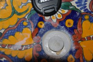
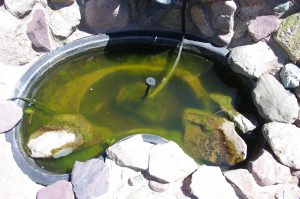
Phosphate build-up in my sink and pond
4. 1/5/12- My letter to Dean Lloyd and Karen Coyote (fellow OPP activists)
Dean and Karen,
These are good points you list. However, based on our meeting today and our collective history on this issue, I think we have a much stronger case than what you mention here (below). Karen you might want to refer to some of these points at the Friday meeting. You might first outline to the Board a brief history of our efforts so far:
1) Beginning about 3 years ago, a number of Baca residents began writing letters to the Eagle and/or the Water and San Board complaining of health problems that could be due to the OPP and chlorine that the Water and San District has been adding to water in Chalet I and II. The response of the Water Board and SDMS was not to apologize and try to remedy the situation. Rather, the SDMS lawyer sent intimidating letters to the resident/customers that threaten legal action against those customers/residents who have expressed their concerns
2) The Baca community subsequently has accumulated many signatures of local residents on petitions and presented these to the Board and SDMS
3) Baca residents have numerous written letters to the Board and SDMS expressing their concerns about the health effects of the OPP and chlorine additions to our water
4) Baca residents have held several informational meetings re: water quality issues and posted some of this information on local websites/blogs in an attempt to educate Baca residents re: the issues of water quality here. The SDMS lawyer sent a letter to these individuals who posted youtubes on websites, threatening legal action against them for simply exercising their First Amendment right of freedom of speech. This heinous letter of intimidation is in violation of the first amendment rights of free speech accorded to all American citizens since this country was founded. A lawyer should know about the First Amendment.
5) One Baca resident has employed a top notch water lawyer who wrote a letter to the Board/SDMS citing their numerous violations of state laws and procedures
6) Baca residents have staged coordinated efforts to be present at several Board meetings to express their concerns
7) Baca residents have staged OWS (Occupy Water and San) protests to try to get the Water and San board to respond to our concerns
And despite all these good faith attempts on the part of Baca residents/customers to express their concerns, Water and San has still not solved the problem. There has been only stonewalling, denials, insults, and above all stalling. Why? T hat is the $64,000 question. Why are they so committed to SeaQuest, this secret, proprietary blend of chemicals for which no short- or long-term health studies have been performed.
8) Furthermore, the Water Board is proposing to initiate an 18-month program to determine whether there is a corrosion problem. This amounts to further stalling and refusal to fix the problem that concerned citizens have documented.
9) In fact, Steve Wade’s proposal for the past 2+ years has been that the Water Board needs to conduct in-house tests to determine if there is a corrosion problem. This was never done and so it is entirely possible there is no corrosion problem. This in-house test would require that Water and San stop their daily additions of OPP to our Baca water and do the corrosion study correctly. As opposed to the 18 month study proposed by the Board, this would only take 2 months and would yield far more accurate and useful information.
And also emphasize that it would be easy to solve the “corrosion problem” (if indeed there is one- we still don’t know) and that the state regs do not prevent us from solving this problem on our own. In fact we have letters from state officials to the effect that substitutes for OPP exist, that state permission to change strategies is not needed, and that they apologize for not monitoring this situation adequately to make sure the Board and SDMS followed proper procedures for demonstrating the need for establishing a corrosion program in the first place.
In terms of what you have written below:
10) I guess I would put a question mark after the first sentence of #3. Perhaps ask Lisa just how much our debt actually is and add that to the platform.
11) The platform could also have something about making sure the Water and San. Board is more responsive to the expressed concerns and needs of its customers. 10) Perhaps you want to raise the question (you kind of did) of whether we still need SDMS at all. You might mention something about restoring local control of our water district and our water quality.
12) You also might mention something about protecting the long term pristine quality of our aquifer from these potentially toxic chemical additions.
13) And you might mention something about the possibility that the Board members and SDMS could be personally liable for the costs of short- and long-term health problems of our local residents/customers. And ask which insurance company carries their liability insurance.
Just some ideas,
Eric
5. 2/9/12 Letter to A.J. Beckman from Eric Karlstrom
AJ Beckman
2/9/2012
Special District Management Services (SDMS), Inc.
Dear AJ,
We appreciate your efforts to set up a time when we, the Baca community members, can carry on a phone dialogue with the members of SDMS on Valentine’s Day (2/14) at 4 pm. Since there will be many participants, I would here like to apprise you of some concerns that I and we in the community have regarding our water district. Hopefully, we can address some of these issues in the conversation.
In order to provide the “big picture” and the apparent gravity of the problems we face, I’d like to report two recent conversations I had with other community members. First, one member of the POA Board noted that about half the houses in the Baca are currently for sale. Second, when I asked Dr. Dean Lloyd to estimate for me the percentage of his clients that have health complaints that seem to be related to the quality of our Baca water, he stated “about half.”
In other words, it appears that we have a health problem that is not of our imaginings and that we are not just a “few disgruntled individuals,” as Chris Canaly recently characterized us.
Here is a brief, general history of our attempts to solve these problems. (Specific dates might need to be corrected).
1) Beginning about 3 years ago, a number of Baca residents began writing letters to the Eagle and/or the Water and Sanitation Board complaining of health problems that they thought were due to the chemicals (OPP and chlorine) that the Water and San District has been adding to water in Chalet I and II. The response of the Crestone Eagle was not to print the letters but rather to pass them along to the BGW&S Water Board and SDMS. The response of the Water Board and SDMS was not to apologize and try to remedy the situation. Rather, the SDMS lawyer sent intimidating letters to the resident/customers threatening legal action against those customers/residents who expressed their concerns.
2) When Water and Sanitation employee Steve Wade tried to work with and help the Baca residents with health complaints and tried to convey their concerns to the Water Board/SDMS, he was fired for his efforts. What is particularly frustrating is that Wade had developed a strategy by which the health concerns of Baca residents might have been removed.
3) Baca community members have met amongst ourselves numerous times in order to educate each other and find ways to resolve these problems. When community members posted some of this information on local websites/blogs in an attempt to educate Baca residents on the water quality issues, the SDMS lawyer sent a letter to these individuals threatening legal action against them for exercising their First Amendment right of freedom of speech. This heinous letter of intimidation is in violation of the First Amendment rights of free speech accorded to all American citizens since this country was founded.
4) Baca community members have attended numerous Water Board/SDMS meetings in our attempts to express our health concerns and our determination that these concerns should be addressed and resolved.
5) Baca community members have gathered many signatures of local residents on petitions and presented these to the Board and SDMS.
6) Baca residents have written numerous letters to the Water Board and SDMS expressing our concerns about the health effects of the OPP and chlorine additions to our water and requesting that the our health concerns be addressed and resolved.
7) One Baca resident has paid for legal assistance from one of Colorado’s top water law firms. After studying the issues, this firm wrote a letter to the Board/SDMS citing their numerous violations of state laws and procedures.
8) Baca residents have staged OWS (‘Occupy Water and San’) protests to try to get the Water and San board to respond to our concerns.
9) Although the Water Board/SDMS have frequently told us that changing strategies would be a lengthy process that would require approval of the state, the state health officials we have talked to have denied this.
10) The fact is that federal and state regulatory agencies currently do not have the authority, money, or expertise to enforce existing regulations. Our government has shifted from a government of, by and for its citizens to a government of, by, and for corporations, i.e., a “corporatocracy.” We in Crestone realize that corporations are not persons and we see through these legal tricks. In fact, certain Supreme Court decisions declared decades ago that all laws passed in violation of the U.S. Constitution are null and void.
In America, up until quite recently, the general business model has been: “The customer is always right.” However, despite all these good faith attempts on the part of Baca residents/customers to express our health concerns, the Water Board/SDMS has still not resolved the problem. There has been stonewalling, denials, insults, and above all, much stalling, which continues to this day. The question is why? That is the $64,000 question. Why is the Water Board/SDMS so committed to SeaQuest, this secret, proprietary blend of chemicals for which no short- or long-term health studies have been performed? Obviously, we can only speculate. And one speculation is that you are harming us, either deliberately or though ignorance/incompetence/malfeisance.
11) Currently, the Water Board/SDMS is proposing to initiate an 18-month program to determine whether there is a corrosion problem. This only amounts to further stalling and a refusal to fix the problem that concerned citizens have documented.
12) In fact, as you know, our water system is almost entirely comprised of plastic PVC. Steve Wade’s proposal for the past 2+ years has been that the Water Board needs to conduct in-house tests to determine if there is a (copper) corrosion problem at all. As Water and Sanitation never did a proper study to determine whether or not there is a corrosion problem, we feel that by adding this industrial product (Seaquest) to our water supply to cure what may well be a ‘non-problem’ the Water Board/SDMS may be creating a far worse (health) problem. What is more important: the health of human beings or health of some old copper pipes? It is entirely possible there is no corrosion problem. This in-house test would require that Water and San stop their daily additions of OPP to our Baca water and do the corrosion study correctly. As opposed to the 18-month study proposed by the Board, this would take less than 2 months, would yield far more accurate and useful information, and would not accrue additional costs to the district owners, that is the Baca Grande Water & Sanitation District customers.
I would also like to reiterate that if it turns out there is a “corrosion problem,” state regulations do not prevent us from solving this problem on our own. In fact we have letters from state officials to the effect that substitutes for OPP exist, that state permission to change strategies is not needed, and that they apologize for not monitoring this situation adequately to make sure the Board and SDMS followed proper procedures for demonstrating the need for establishing a corrosion program in the first place.
Finally, I have two more very major concerns that I will express in terms of questions:
13) I have heard through the Crestone grapevine that, due to the passing of a bond request approved by Saguache County voters, the Water Board/SDMS has borrowed some $26 million on our behalf. Can I ask you what that $26 million has gotten for us and when/if we can expect the bond to be paid off in the future.
14) For the second time in the past several years, there is an attempt to close off public access to the area near the Cottonwood Creek trailhead where Water and Sanitation has a large storage tank. County employees have informed me that Water and San supported the blockage of one of two roads that give access to this publicly-owned land. Forgive my skepticism, but does the closing of this road and the attempt at removing public access to this area have to do with long term ownership of water rights of Cottonwood Creek?
The citizens and customers of the Baca/Grande pay your salaries. You work for us. I believe we deserve direct and sincere answers to all these questions and an immediate solution to the water quality/health concern issues we have raised.
Sincerely yours,
Dr. Eric Karlstrom, Emeritus Professor of Geography, California State University Stanislaus
II. Northern San Luis Valley Weather Modification/Drought/Water Meetings
1. 4/27/2012
Present: Peggy Godfrey, Virginia Sutherland, Kelly Smith, Jim Swanson, Gerald Gray, Dennis Crown, Eric Karlstrom
Dr. Karlstrom’s Notes From Meeting Based on Comments of Attendees:
The Rio Grande Conservation District- very self-serving, has millions in the bank, behind the sub-districts, has $700,000 attorney and $500,000 engineering budget this year. They fought AWDI in late 80’s. They get 2.5 mils. Dave Robbins, Van Deveer, Alan Daveys, run this. They own run closed basin project. BLM pumps the water. Very big budget. We need FOIA. Art Hutchison had copy of the document. They have $1 million budget/year. They pay ¼ of this for Rio Grande Cons. District. Federal and state agencies are working together. Screwing the people for the wealthy. Wealthy potato farmers get water back. 12,000 acre feet goes to Rio Grande from Closed Basin Project. Rio Grande is 60%, Conejos R. is 40%. Rio Grande Compact refers to a 1939 document.
1200 miles of Rio Grande River– water is pumped and put into river as part of compact. 1969- mil levy- hired lobbyist to go to Washington to get legislation in 1972. Not abiding by their own statues- engineer for Conservation Dist or Manager- engineer laid out the Closed Basin Project and monitoring wells. Artesian wells were in place- monitoring wells are near flowing artesian wells. Legislation said they would not lower water table more than 2 feet. Now they start with new base line each year. They average project from near Sand Dunes to near Moffat. Wealthy farmers.
2500 acre feet times $260 per acre foot. Subsidized water.
Phase 4 = Baca National Wildlife Refuge- SLVEC has maps of. Former Water Conservation District, employee, Stan Ditmeyer
Two factions in the valley: 1) Range, livestock interests in the northern San Luis Valley who want original moisture.
2) The farmers of spinach, lettuce, barley in the southern San Luis Valley who like no precip in summer, then they can add just how much they want via irrigation.
2) Coors (barley) just surpassed Budweiser. Coors did weather modification in Valley in mid 60’s. Pilot Ben Livingston had CIA, defense contracts and hailed out the valley in mid 60’s, causing freeze clouds, microbursts, illegal, split clouds over La Garita.
Hail suppression. Lawsuit, John Shawcross in early 70’s- Adams State, 70,000 acres of barley
Wilbur Weesecamp has ideas of who is modifying the weather in the SLV.
Hail cannons used in La Garita. Went from daily rain to 0 precip in summer.
Virginia says weather mod in the valley never stopped. She recalls 1991 when 7 inches rain/hail in one hour. Western Weather Consultants now in 40th year of operation.
Who benefits from our drought? Denver Water Board (Dave Robbins, et al.)
Check out the movie, Total Recall, with Schwartzenneger. Perhaps we need class action lawsuit.
The Closed Basin Project gets its water strictly from confined aquifer. There is decreasing rim flow. Subject of eminent domain. The surface rights are damaged by wells.
Look at competing economic interests. On one side you have ski areas, that feeds reservoirs, that feeds Denver municipal area, and lettuce/barley farmers – Dave Robbins and Denver Water Board, all these profit from sending moisture north of SL valley. This creates cheaper land values in SLV and leads to eminent domain.
The (government water) “model” dates to 1999. Hunt springs went dry in 1950.
Weather modification affects water tables. Mountain springs are going down. Virginia remembers when she and her father got 5000 tons of hay/yr- now its down to 10-20 tons/yr or none.
There was a drought in the 1950’s. Gary Boyce has information. We need FOIA for federal documents.
Cost now is $260/acre feet- Subdistrict 4 and 5. We’ve seen 1300 feet of depletion. Costing $30,000. Go to pump well users
Jim Swanson is the water commissioner. Now water table at 70 to 90’ depth- also wherever there is military traffic, weather dries up. (And Crestone/Baca-Saguache County have seen lots of Air Force drills over the years- this has been the subject of heated local environmental campaigns.)
2. May 2, 2012
SLV Closed Basin Project- 2nd Meeting at lunch with Gerald Gray, Kelly Smith, Virginia Sutherland, Dennis Crown and Peggy Godfrey (also Jim Hanson)
Spinach, lettuce, barley interests,
3. 4/30/2012 Conversation with local rancher and water activist, Peggy Godfrey
In 1980’s, there was testing, with lysimeters to estimate the amount of evapo-transporation in the valley. Check with Bureau of Reclamation for data base. According to Peggy, the Closed Basin Project allocation of water from the SLV (instead of Rio Grande) is based on the assumption that about 60,000 acre feet of water is lost to ET each year and that this water is excess water not being put to beneficial use.(?!) The entire “water right” is based on ET from native vegetation- mostly Chico bush and Rabbit Brush. Actually, they only are now taking about 17,000 to 25,000 acre feet/yr and this is the most they can get with the system they have. But they have water rights for 100,000 acre feet. This is considered “conditional use.” The most they have pumped is 44,000 acre feet in 1997.
In 1982, there was a Final Environmental Statement then Supplemental Environmental Statement for Closed Basin Project done by Bureau of Reclamation. (BLM?)
The Closed Basin Project includes 130,000 acres in SLV and takes water from closed basin (presumably the unconfined aquifer- but actually both the confined aquifer and unconfined aquifer) to send to New Mexico and Texas under the requirements of the Rio Grande Compact of 1939. The Bureau of Rec (or BLM) created the infrastructure and the Colorado State Rio Grande Water Conservation District manages the project and owns the water. (Steve Van DeVeer manages the Conservation District (“he’s a snake”) and Dave Robbins is the lawyer). They say they are not taking water from the confined aquifer. Rio Grande Water Conservation District was formed in 1968 after New Mexico sued to get Colorado to obey terms of the Rio Grande Compact of 1939.
It wasn’t until 1980 that the Conservation District got enough money to carry out the project. The project was initially to make sure NM and TX got their fair share of Rio Grande water as well as repay a debt of 900,000 acre feet. However, by the terms of the agreement, when Elephant Butte reservoir in NM overflowed in 1985, the 900,000 acre feet debt was forgiven. But they still went ahead with the 137 wells to a depth of 135 feet.
AWDI and the Closed Basin Project were both issues in the mid-80’s. Dave Robbins was the chief attorney that fought AWDI. It could be that the AWDI thing was set up to take the attention away from the Closed Basin Project. And AWDI was set up to lose.
Today, in Albuquerque, the cost of 1 acre foot of water is $5-6,000.
One local called this thing a “conspiracy of self-interest involving a few wealthy potato farmers in the SLV.” By sending SLV water to NM and TX rather than Rio Grande Water (which compact calls for) these few farmers are benefited.
The project, including 137 wells (each 135’ deep- therefore into confined aquifer) and 44 miles of canal was built in early 80’s. Pumping began from Phase 1 and 2 (near Great Sand Dunes National Park) in mid 80’s. Pumping began in Phase 3 (Hooper area) in 1989. Pumping began in Phase 4 (south of Moffat) in 1992. And pumping began in Phase 5, west of Moffat in 1993. 500 acre feet evaporate from the canals each year.
Currently, 90 to 91 of the 137 wells are being pumped. Because Closed Basin engineers tried to pump too fast- the wells went temporarily dry and oxygen was exposed at depth, causing “biofouling”- the formation of iron and manganese oxides that coat screens. New wells can only be 60 to 80’ deep- (unconfined aquifer) and water from these is often briny.
Project gives 5,000 acre feet of “mitigation water” to Blanca and Alamosa National Wildlife Refuges.
Meanwhile Kerber, San Luis and Saguache Creek used to flow at the surface but no longer flow at the surface.
10,000 to 15,000 acre feet comes out of the mountains each year.
In April of 1988, the water table at Peggy’s place in Moffat was 6 to 10” down. Now (2012) it is 5.5 feet down. (Many plants in this are need water table to be within 2 feet of surface.) Water tables are dropping all over the valley due to pumping of closed basin project as well as center pivot irrigation.
In 1979 on the Baca Ranch, there were some 325 artesian wells bubbling up under artesian pressure- they came from the confined aquifer and came up as livestock wells, 2” diameter. In 1989, there were only 175 left. Today, you can hardly find any. Today, all these wells mix confined and unconfined aquifer waters. And the artesian wells “sand in.”
Ranchers have priority surface and well rights that precede the closed basin project (1985) in the priority system. However, if the rancher goes broke and sells, then the purchaser gets the senior water right.
The government is creating the biggest problems, but the rhetoric is that it is the private farmer’s wells that are causing the drawdown of the water tables etc.
2002 was the worst drought in 300 years based on tree-ring studies and weather records. The entire state is in a drought. Satellite surveys and vegetation analyses by Agro-engineering through 2008, showed the extent of damage. – a 25-yr drying trend in the N and Eastern parts of the valley.
Now Northern Valley ranchers are applying for drought insurance.
The Baca Ranch- later Baca National Wildlife Refuge- had best water rights in the valley. This area is a sump that gets recharged first. That is, the water table is higher here. Eddie Clayton has grown hay here for some 50 years. In the past, they got thousands of tons of hay. Bob Bunker managed the Baca Ranch between 1969 and 1989. In 2012, there is only 12% of the hay crop there was in 2005.
January Lake was a perennial wetands- the pasture there produced enough hay for 1200 head of cattle.
Even here, the hay crop
The combination of drought and Closed Basin Project is causing economic collapse- aided by spraying and weather modification. After the rancher’s sell out, new buyers get the water rights.
Due to floodwater irrigation, water tables were very high in the 1950’s. In the 1960’s, the pivot sprinklers started, by the 70’s there were many pivot sprinklers.
In the Hooper area, hot water is reached at 2000 feet depth. At the Sand Dunes, rock is encountered at 9,000 feet depth. In the SLV, water moves west to east, then North to South. At present, water table at Hooper is 40’ down.
III. The Battle for Access to Public Lands and Public Trails (The case of Cottonwood Creek and the closure of the Tranquil Way bypass road).
1. 11/21/2012 email by ETK re: number and nature of trails (from north to south) along western side of Sangre de Cristo Mountains between Hayden Pass and the Great Sand Dunes National Park and Preserve:
Using my 2001 map, (Sangre de Cristo and Great Sand Dunes National Parks Trails), and starting at Hayden Pass in the Northern Sangres (west side), these are the prominent creeks with trails (some small creeks don’t have trails)
1) Hayden Pass Trail- very short
2) Black Canyon Trail- 5.7 miles to Crest Peak
3) Hot Springs Canyon Trail (4.8 miles to upper west ridge of Cottonwood Peak)
4) Garner Creek Trail (5 miles to pass)
5) Major Creek Trail (6.3 miles to pass)
6) Cotton Creek Trail (7.4 miles to Cotton Lake)
7) Wild Cherry Creek Trail (4.4 miles to lake)
8) Rito Alto Trail (6.6 miles to lake, 9.3 miles to Hermit Pass)
9) San Isabel Trail (5.7 miles to lake)
10) North Crestone Creek Trail (5.8 miles to lake)
On the Southern Sangre de Cristo portion of my map there is:
11) South Crestone Creek Trail (4.1 miles to lake)
12) Willow Creek Trail
13) Spanish Creek Trail*
14) Cottonwood Creek Trail (5.8 to Milwaukee Peak saddle)*
15) Deadman Creek Trail (old unmaintained trail)
16) Pole Creek Trail (old unmaintained trail)
17) Sand Creek Trail- upper valley section (9.7 miles)
18) Medano Creek Trail
19) Mosca Creek Trail
20) South Zapata Creek Trail
On the Old map (1865) from north to south we have:
1) Wild Current Creek which merges with Holman Creek from north
2) Leroux Creek
3) Riviere Les Trois Tetons*
4) unnamed creek
5) Chatillon Creek
6) unnamed Creek
7) Sandy Creek
8) Mosca Creek
2. Save Our Trails to Saguache County Board of County Commissioners from Baca residents, Lisa Cyriaks and William Folk- Letter 1 (9/19/2008)
Crestone, CO 81131
September 19, 2008
Saguache County BOCC PO Box 326 Saguache, CO 81149
The first point contained in Saguache County 96-G-7 Reception No. 316837 recorded September 17, 1996 states that “all public roads located within Saguache County, Colorado that have not been heretofore publicly vacated by the BOCC are hereby designated public highways”. The resolution goes on to define public roads and public highways used in Resolution 96-G-7 to include: “highways, roads, mining roads, logging roads, wagon roads, trails, horse trails, hiking trails and footpaths”.
Through our research we have determined that the trails on Cottonwood Creek and Spanish Creek are pre-existing trails and have been in accepted use for decades as being for public use as a means of access to the peaks located above Crestone/Baca and to the US Forest Service lands beyond – historically the San Isabel Forest and more recently, the Rio Grande Forest.
The third point in Saguache County 96-G-7 states that “neither private nor public tracts of land traversed by these public roads may be fenced, gated or otherwise obstructed by any means whatsoever without the express written consent of the BOCC.” We have yet to uncover evidence that subsequent to 1996 the Saguache County Board of County Commissioners took any formal action vacating or changing the use of these trails.
That there is a process for an owner of private land to close a public highway is supported by C.R.S. 43-2-201.1 (4)(a) which states that the owner may post their intent to close a road, but the owner is also required to promptly notify the BOCC and that the BOCC will publish notice of proposed closure within sixty days. If the BOCC receives no objection to such proposed closure within eighteen months, the road described in the notice shall be closed to public access.
Therefore, we formally demand that the Saguache County Board of County Commissioners enforce the policy defined in sixth point stated in Resolution 96-G-7 and require the removal of the “No Access” signs at Cottonwood Creek and Spanish Creek within 10 days. This policy is supported by C.R.S. 43-2-201.1 that identifies that any person other than a governing body of a municipality or county who intentionally obstructs public access to public lands without good cause commits a class 3 misdemeanor.
To support our assertion that these are public access trails we put forward the following documentation:
Cottonwood Creek 1. Rio Grande National Forest Rocky Mountain Region for Sand Creek Land
Trails 743,877,862. The 1995 description of access includes the Cottonwood Creek access. The trail inventories from 1994 to 1996 include this trail and indicate that the Forest Service maintained this trail from 1994 to 1998.
2. The BOCC will be receiving a packet of historic maps that document that historic use of the Cottonwood Creek Trail, marked with Forest Service signage as FDT 743 (which number correlates with the trail in the San Isabel National Forest that links to the Cottonwood Creek Trail) into the 1990s.
3. The Manitou Habitat Conservation Plan created by The Conservation Fund in July 1997 acknowledges “the existing jeep trail that provides access to National Forest lands”. This plan was written to create the basis for funding the current conservation easement on Manitou Foundation lands by The Jackson Hole Preserve.
Spanish Creek 1. The recorded acknowledgement of the validity of a prescriptive right of the public to continue to utilize this pack trail (Spanish Creek Pack Trail) by Haidakhandi Universal Ashram. Reception No. 269314 Book 435 Page 822 recorded May 19, 1987. This document goes on to clarify that the prescriptive right does not allow the use of motorized vehicles or the carrying of hunting weapons on the Pack Trail. These provisions are to be included in any contract for sale by the Haidakhandi Universal Ashram.
2. The March 26, 1987 Planning Commission minutes recording the inclusion of this document granting the prescriptive easement as part of the plat vacation approved.
Both locations: 1. Statements previously submitted by various residents and property owners asserting to ongoing and continuous use from the 1950s to present. 2. Maps that document the existence of these trails:
• Baca Grande subdivision planning map dated 1971 showing these trails
• USGS map hanging in the courthouse outside the Land Use office showing these trails. This map is dated 1979 using 1920s USGS data.
• USGS Department of Interior USDA Crestone quadrangle map produced by USGS in 1982 and revised by the USDA Forest Service in 2001 showing these trails.
• Colorado recreation Maps printed by KRD Enterprises Inc. using USGS, BLM, and DOW data. Printed in 1985.
3. The greenbelts agreement referenced in several legal documents between the Baca Grande Corporation and the Baca Grande POA that subjects “greenbelt” properties reconveyed to the Baca Grande Corporation and to the Lindesfarne Association that extends permission for reasonable public pedestrian and equestrian ingress and egress over these former “greenbelt” properties.
4. References from Guidebooks describing various approaches to various peaks in the area.
Borneman, W.R., and Lampert, L.J., 1994, Colorado’s Fourteeners: The Classic Guide to Colorado’s Fourteeners, 3rd Edition, Pruett Publishing Company, Boulder, Colorado, 251 pp.
Jacobs, R. 2000, Colorado Mountains, 10th edition, The Colorado Mountain Club Press, 365 pp.
O’Hanlon, M., 1999, The Colorado Sangre De Cristo: A Complete Trail Guide, Hungry Gulch Press, Westcliff, Colorado, 71 p.
Roach, G., 1999, Colorado’s Fourteeners, From Hikes to Climbs, 2nd Edition, Fulcrum Publishing, Golden, Colorado, 306 pp.
Additional Reasons to consider keeping these trails open:
In recent master planning meetings (February and March 2008) the public indicated widespread support for continuing to provide access to public lands. Ninety per cent of participants countywide felt it was important to very important that access to public land and regional trails be kept open. In the Crestone/Baca area, ninety-three per cent supported continued use of existing trailheads and creation of new trailheads accessing public lands.
These trails play an important economic role in our communities. The Colorado State University extension service conducted a study in August 2007 determining the loss of revenue experienced when access to Fourteeners is closed. The study yielded three significant findings:
1. Fourteener closure has the potential to significantly impact local economies.
2. Fourteener climbers place a high value on access to the peaks, spending as much as $336 per person per expedition.
3. Much of this money is spent locally, and it is worthwhile for local communities to develop creative solutions to ensure that peaks remain open.
We hereby demand that the county commissioners honor the terms of Resolution 96-G-7 and that they remove the signs posted denying the public access at Spanish Creek and Cottonwood Creek. We also ask that the county commissioners proceed with a determination protecting the rights of all citizens and affirm this public access. The mountains are meant to be free and open access for all – a place to experience wilderness.
Respectfully submitted:
Lisa Cyriacks
William Folk
3. Save Our Trails to BOCC from Baca residents, Lisa Cyriaks and William Folk (10/10/2008)- Letter 2
Crestone, CO 81131
October 10, 2008
Saguache County BOCC
PO Box 326
Saguache, CO 81149
Dear Commissioners Spearman, Pace and Joseph,
Thank you for this opportunity to clarify what Save Our Trails is asking. In Resolution 96-G-7, the fifth “Whereas” cites Colorado law “that recognizes that all of these various “public ways” are public highways, and public highways include:
1. all roads over private lands dedicated to public uses by due process of law and not vacated by an order of the BOCC
2. all roads over private lands that have been used adversely without interruption for 20 consecutive years
3. all roads over the public domain, whether agricultural or mineral.”
This language in Resolution 96-G-7 is almost verbatim from CRS 43-2-201. I have attached PDFs from the CRS for 43-2-201 and 43-2-201.1 in addition to a copy of Resolution 96-G-7. CRS 43.2.201.1 outlines the process by which a private landowner can closed an abandoned “road” that crosses their property. It also outlines the penalty for obstructing a public way.
Based on this information, and the prescriptive easement dated May 19, 1987 on the Spanish Creek Pack Trail, we do not believe that RS2477 is the sole basis for reviewing trail access. The basis for our request is: “all roads over private lands that have been used adversely without interruption for 20 consecutive years” which is Colorado law.
Specifically what we are asking is that Point #4 under NOW THEREFORE BE IT RESOLVED (96-G-7) be enforced. Specifically that signs may be posted at intervals indicating that surrounding property is private property or not for public use, but that “no such sign will purport to limit the absolute right of the public to use such road, or deny access to the general public”. In other words, that the current signs stating “Private Property, No Trespassing” and “No Public Access” be changed to reflect that these trails are crossing private property but still allowing for public access. Language may be added to state: “Stay on the trail”, that the “Access is Non-motorized”, “No littering” etc.
Or, if acceptable language cannot be agreed upon, that the existing signs be removed as outlined in Point #6 under NOW THEREFORE BE IT RESOLVED (96-G-7).
Sincerely,
Lisa Cyriacks
William Folk
4. Letter from Cottonwood Study Group to Saguache Co. Commissioners (BOCC; 4/25/2012)
COTTONWOOD STUDY GROUP
c/o Christian Dillo, Crestone Mountain Zen Center
P.O. Box 130
Crestone CO, 81131
Phone: 719-256-4692
Saguache County
Board of County Commissioners
April 25, 2012
Re: Proposal – Parking Lot on County-Right-of-Way at Camino Baca Grande to Create Public Hiker Access to Cottonwood Creek Trail
Dear County Commissioners,
The purpose of this proposal is to explore the possibility of an official trailhead for the currently closed and unmaintained Cottonwood Creek Trail on the County’s right-of-way on the east side of Camino Baca Grande south of Cottonwood Creek. The trailhead would be constructed and maintained by the Saguache Ranger District/Field Office and include a parking lot (size to be determined according to 2012 user data), a toilet, and an information kiosk.
The overall goal is to create a long-term solution for public access to the Rio Grand National Forest via an official Cottonwood Creek Trail that would be maintained by the Saguache Ranger District/Field Office.
We think that Saguache County, the Baca Grande POA Membership, and the larger non-local public would benefit from the realization of this project.
We hope to discuss this proposal at the County Commissioners’ meeting on May 15, 2012.
Background
For years, the Manitou Foundation has been seeking a solution to public access issues around Cottonwood Creek trail that is in accord with its strict conservation commitments. The narrow band of land that the Manitou Foundation owns along Cottonwood Creek currently blocks hiking access to the Rio Grande National Forest. The Cottonwood Creek trail is popular both with locals for short day hikes and with a larger non-local hiking community for access to two “14ers,” Crestone Peak and Crestone Needle.
The Manitou Foundation has been concerned about unauthorized use of the Cottonwood trail to gain access to the National Forest. Related to trespassing is the associated issue of unregulated parking on the private roads that lead to the de facto trailhead. Attempts to regulate trespass have essentially failed. Other negative impacts to the land under Manitou Conservation include trash and human waste issues, negative influence to riparian areas and watershed health, soil erosion on user-defined trails, trail braiding and proliferation and dispersed campsite proliferation – all of which violate the Manitou Conservation Easements and are therefore unacceptable to the land owner (Manitou).
Since there is no public access to the National Forest in the Cottonwood area, the USFS Saguache Ranger District cannot and does not effectively manage that part of the Sangre de Cristo Wilderness, nor does it maintain the Cottonwood Creek trail. Besides not managing to prescribed Wilderness standards activities such as hiking and climbing in the popular drainage, and directly related to the lack of legal public access, neither the USFS nor CDOW manage for the various hunting seasons as well, which has resulted in numerous alleged indiscretions and illegalities related to wildlife that are unacceptable to these agencies and the Manitou Foundation.
Cottonwood Study Group
In January 2011, a group of stakeholders started a series of meetings facilitated by Christian Dillo of the Crestone Mountain Zen Center to explore possible solutions for the problematic situation described above. The following parties have regularly participated in Cottonwood Study Group:
- Manitou Foundation
- Saguache Ranger District/Field Office
- Colorado Mountain Club
- San Luis Valley Eco System Council
- Karma Thegsum Tashi Gomang (owner of the Tashi Gomag Stupa)
- Baca Grande Water and Sanitation District
- Baca Grande Property Owners’ Association
- Crestone Land Trust
Proposed Solution
The purpose of the Cottonwood Study Group is to understand the relevant factors in the Cottonwood access issue and to find a long-term solution for hiker access to the west side of Crestone Peak, Crestone Needle and the Cottonwood Lake that balances private property rights and the need for public access.
Currently, two alternatives are being discussed as possible solutions:
Alternative 1 “Camino Baca Grande”:
A hiking trail via POA greenbelt, Manitou, Water and Sanitation District and Forest Service property that would connect Camino Baca Grande with the “Stupa Road” and the existing Cottonwood Trail plus a trailhead facility (incl. parking lot for probably 10-15 cars, toilet, information kiosk) located on the County right-of-way on the east side of Camino Baca Grande south of the Cottonwood Creek. From there a the trail would go up on the south side of Cottonwood Creek (POA greenbelt), outside of the immediate creek bed. The trail would meet up with the Stupa Road. Hikers would cross Cottonwood Creek on the Stupa Road and then turn east to use the established trail on the north side of Cottonwood Creek. (Forest Service experts and engineers are available to help with the exact routing of the trail on POA greenbelt.)
MOUs regarding the use of Manitou and Water and Sanitation District property have been drafted and agreed upon and are currently being finalized by the Forest Service administration.
The POA Board of Directors has rejected the idea of a trailhead facility in the POA greenbelt area, but is open to exploring the possibility of granting use of the greenbelt south of Cottonwood Creek for a hiking trail, which is mostly in place already.
Alternative 2 “Combined Trail/Stupa Access for Hikers and Vehicles”
Obtain one or more POA lots (trade or purchase) near Dreamway (aka the “High Road”) north of Cottonwood Creek (or alternatively near the
“Stupa Road” south of Cottonwood Creek). Use lot(s) to create a through-road that would connects with either the “High Road” or the “Stupa Road.” Parking would occur on Water & Sanitation District property (as it does now in an unregulated fashion) and would need to be negotiated with the Water & Sanitation Board.
Alternative 2 was developed to address (1) the need for vehicular access to the Stupa (currently via the privately owned and poorly maintained “High Road” aka East Dreamway) and (2) the opposition from POA members who own land near the parking area proposed in Alternative 1. More detailed information regarding the viability of Alternative 2 (availability of lots, necessary rezoning/variance procedures, funding, agreement from neighbors) is currently being researched and not available at this point.
For both alternatives, access and parking will be limited (or not) based on an assessment of carrying capacity. The group has developed a strategy with the Forest Service to make 2012 an “Open Season” using infrared trail and vehicle counters and a survey to collect visitor data during of the course of the 2012 hiking and hunting season.
Proposal to the Saguache County Commission
The Cottonwood Study Group respectfully requests to be put on the agenda of the May 15, 2012 County Commissioners Meeting to present and discuss the County’s possible participation in the “Camino Baca Grande” access proposal.
Specifically, we would like to see the following question answered by the County Commissioners:
Would Saguache County be able and willing to give a permanent public easement for a trailhead facility on the County right-of-way along Camino Baca Grande south of Cottonwood Creek under the condition that the POA Board of Directors grants use of the greenbelt for a permanent hiking trail?
Please refer to the attached map for the exact location of the proposed trailhead and trail.
The POA Board of Directors has indicated that it would only be able to discuss the use of the greenbelt as described in Alternative 1 once the County has giving its approval for a parking lot.
All related issues including but not limited to trail engineering, construction, maintenance, administration, access limitation, and funding are intended to be resolved through the cooperation of the stakeholders. However, most of these issues cannot be addressed until MOUs regarding permanent public easements will have been obtained from the affected landowners and authorities, i.e., Saguache County, the Baca Grande POA, the Baca Grande Water & Sanitation District, and the Manitou Foundation.
We look forward to exploring the possibility of a public Cottonwood Creek Trail with you. Thank you for your consideration.
Sincerely,
Christian Dillo
Cottonwood Study Group (Crestone Zen Center)
My letters to Saguache County Commissioners, Baca Grande Property Owners Association, Baca Grande Water and Sanitation District
5. Letter to Saguache County BOCC from Dr. Eric T. Karlstrom, May 15, 2012
Saguache County
Board of County Supervisors
Re: Christian Dillo’s request that the Saguache County Supervisor’s approve the “Cottonwood Study Group’s” “Camino Baca Grande access proposal” (April 25, 2012).
Baca Grande citizens have several concerns regarding the Cottonwood Study Group’s current request for Saguache County supervisors to approve a new parking lot in a designated green belt in the Baca Grande subdivision. It seems that several legal policies and statutes are being violated by Christian Dillo and his associates in the Cottonwood Study Group. First, Statue CRS 30-28-110 stipulates that such proposed changes require approval by the county planning commission as a first step. Second, the MOU which Dillo describes has not been signed by the parties involved. Furthermore, Dillo offers no details as to what the MOU actually stipulates or if it would even be legally binding.
Third, the unilateral closing of the “Tranquil Way bypass” road by the Greenway family is in violation of several statutes and laws. This land-use change was never brought before the Saguache County planning commission for approval. Indeed, it probably would not have received approval because the closing this historic access road probably violates the RS2477 since the “Tranquil Way bypass” meets the definition of “historic and prescriptive use.” This road provided access to the Cottonwood trailhead and the Tashi Gomang stupa via the “Stupa Road” (aka “Dream Way,” the “High Road,” and the “Mine Road”) decades before the Greenways purchased their lots (4324, 4323, and 4322, now 4322-C) in 1998, 2001 and 2002. Indeed, the Crestone rumor mill has it that the Greenways, who are German citizens who live most of the year in Germany, purchased these lots at the urging of their fellow German, Christian Dillo. There is further speculation in the Crestone rumor mill that the next pro-active and illegal action of Dillo’s group would be to close the “High Road” itself, perhaps between the Zen Center and the Japanese Shumei Institute, thereby eliminating public access to the Cottonwood Creek watershed.
Dillo’s current proposal is being advanced by essentially the same people who in recent years called themselves the “North Access Team” and “Crestone Spiritual Alliance.” Several years ago, these individuals tried to eliminate public access to public lands by closing 1) the Cottonwood Creek trailhead on the “Stupa Road,” 2) the South Crestone Creek and Willow Creek trails at the Pine Cone Way cul de sac, 3) the Copper Gulch Road at Brookview Way, the Willow Creek OL, and Summitville OL, 4) the entire Spanish Creek drainage, and 5) the jeep road immediately north of Shumei Center on East Dream Way (the “Stupa Road,” aka “the mine road”). All these historic points of public access to public land occur along the eastern margin of the Baca Grande subdivision.
The individuals associated with the current proposal and past attempts to eliminate public access to public lands are associated with the Manitou Foundation. The “bargaining chip” they continue to use is that the lowest portion of the Cottonwood Creek trail crosses about 300 yards Manitou Foundation land. In fact, this very commonplace situation is normally remedied quite simply by posting a sign on the trail requesting that hikers stay on the trail and respect private land ownership for the next 300 yards. As a hiker, I have seen many such signs which are sufficient to resolve these issues elsewhere. Furthermore, we question whether land owned by non-profit organizations such as the Manitou Foundation, the Zen Center and Shumei International, qualify as private property. Where are the non-profit Zen Center and Shumei International registered?
My fourth concern regarding the potentially illegal maneuverings of this group is that County Supervisor Linda Joseph has been an active participant in the Cottonwood Study Group. Because Joseph also has a long professional association with the Manitou Foundation, this seems to constitute a genuine conflict of interest. At the very least, she should recuse herself from voting on any issues relating to the Cottonwood Creek land use.
Due to these real and potential legal irregularities, it seems important to point out several errors and misrepresentations contained in this most recent proposal.
1) In paragraph 1 of page 1, Dillo states that the Cottonwood Study Group’s purpose is to “explore the possibility of an official trailhead for the currently closed and unmaintained Cottonwood Creek trailhead,”
In fact, there has been an official trailhead for the Cottonwood Creek trail for many decades. I personally have hiked the Cottonwood trail many times, have camped at Cottonwood Lake, and have climbed all the named peaks the rim the approximately 9 square-mile Cottonwood watershed. These magnificent peaks include Crestone Peak (14,294’), Crestone Needle (14,197’), Broken Hand Peak (13,573’), Milwaukee Peak, (13,522’), and Pico Asilado (13,611’). Until about 2008, there were no attempts to limit public access to this beautiful watershed.
2) Under “Background” (page 1), Dillo states that “the narrow band of land that the Manitou Foundation owns along Cottonwood Creek currently blocks hiking access to the Rio Grande National Forest.”
In fact, nothing blocks access to hiking the Cottonwood trail. My understanding is the U.S. Forest Service maintained the Cottonwood trail from well before the 1950’s to the early 1990’s when Manitou Foundation requested that the U.S. Forest Service stop maintaining the trail. Manitou did not object to hikers using the trail until very recently. Today, hikers continue to utilize the trail that provides access to spectacular opportunities for recreation, tourism, hiking, camping, climbing, and fishing, etc. The American citizens, not German or Danish citizens, own America’s public lands. However, Americans, traditionally, are a generous and tolerant people who are happy to share our abundance with foreigners.
However, we do not tolerate attempts by foreigners and foreign groups to steal America’s resources.
3) In the bottom sentence on page 1, Dillo refers to “unauthorized use of the Cottonwood trail” and “unregulated parking on the private roads that lead to the de facto trailhead.”
In fact, American citizens, by definition, are authorized to access their public lands. We own them just and ultimately the US Constitution guarantees that our government serves us.
Hikers and other recreationalists generally park directly across from the Cottonwood trailhead on land owned by the Baca Grande Water and Sanitation District. In 2008, Manitou Foundation placed a “no trespassing” sign at the base of the trail on land owned by the Water and Sanitation District, not Manitou Foundation. (Water and Sanitation purchased this land from Manitou Foundation in 2002 and it includes the first approximately 200 feet of the Cottonwood trail.)
4) In the top sentence of page 2, Dillo claims that “attempts to regulate trespass have essentially failed.”
In fact, the Manitou Foundation has not reported any incidents of trespass to the local Saguache County Sheriff’s office in this period of time.
5) In this same paragraph, Dillo states: “other negative impacts to the land under Manitou Conservation include trash and human waste issues, negative influence to riparian areas and watershed health, soil erosion on user-defined trails, trail braiding and proliferation and dispersed campsite proliferation.”
However, none of these claims are documented. In fact, I doubt that it would be possible to document that any of these conditions has occurred on the 300 yards of Manitou land across which the Cottonwood Trail traverses. The one unofficial campsite that has been documented was on Forest Service rather than Manitou land.
6) In paragraph 2, page 2, Dillo cites “numerous alleged indiscretions and illegalities related to wildlife that are unacceptable…”
In fact, while there was a documented incident involving a decapitated elk, this occurred on Forest Service rather than Manitou land.
7) On page 2, Dillo lists “stakeholders.” Interestingly, this list does not include the Baca Grande property owners who live in the area affected. Thus, it does not include the American citizens who are their neighbors.
Although Dillo states that the “stakeholders” began meeting to resolve this issue in 2011, in fact, Dillo has been involved in trying to regulate and restrict land use in this area for a long time. In 2007, he made a presentation entitled “The Big Picture Overview” for a Sonoran Institute-facilitated meeting at Colorado College (9/5/2007). And the following year (2008), as noted, Dillo and four others in the Northern Access Team, sought to close off historic trails that provide public access to public land.
8) Dillo outlines two proposed “solutions.” “Alternative 1” would involve placing a parking lot (for 10 or 15 cars), toilet, information kiosk and trail on the POA greenbelt on the south of Cottonwood Creek between the “Stupa Road” and Camino Baca Grande.
However, Dillo himself notes that the POA Board of Directors has rejected the idea of a trailhead facility in this greenbelt. And Dillo does not mention that there is also strong opposition to the entire plan from Baca residents in the immediate area. Furthermore, Alternative 1 does not resolves the issue of “trespass” across the 300 yards of Manitou land that he has identified as the principle problem.
9) In the second paragraph of page 3, Dillo states: “MOUs regarding use of Manitou and Water and Sanitation District property have been drafted and agreed upon and are currently being finalized by the Forest Service administrators.”
However, Forest Service employees report that Manitou Foundation has not signed any agreement that guarantees continued access to Cottonwood trail. Thus, while Dillo implies that the MOU would include an agreement by Manitou to allow hikers to cross the 300 yards in question, this is never explicitly stated. The Commissioners are not provided copies of the draft MOU and are not provided with details of what the MOU stipulates. Furthermore, what assurance is there that such an MOU, if signed in the future would be legally binding into perpetuity? Bottom line is that we are not privy to the details of the MOU so it is impossible to know if such an agreement is legal or how it might impact the issues in question.
10) In Alternative 2, Dillo proposes that someone (the POA?) obtain one or more POA lots near Dreamway (aka “the High Road”) north of Cottonwood Creek to create a through-road connecting the High Road with Camino Baca Grande. Parking could continue on Water and Sanitation land as it does now.
Ironically, “Alternative 2” is exactly what we have had until quite recently, when the Greenway family (owners of lots 4322, 4323 and 4324 at the head of Tranquil Way) placed large boulders across the historic dirt road (Tranquil Way bypass) that had provided access to the High Road for many decades. This unofficial road has been used for well over 20 years and thus meets requirements for “prescriptive use.” Nonetheless, the Greenways, who are Germans that live in Germany for 10 months of the year, closed the road off without a public hearing or approval by the Saguache planning commission. And again, the Crestone rumor mill has it that Christian Dillo (German Zen Buddhist) talked his fellow Germans, the Greenways, into closing off the Tranquil Way bypass, thereby creating the “problem” that now needs a “solution.”
Furthermore, like “Alternative 1”, “Alternative 2” does not address or resolve the issue of access to Cottonwood trail across the 300 yards of Manitou Land.
It is abundantly that this proposal is a present manifestation of an ongoing attempt by a few people to restrict public access to public lands in the Cottonwood and Spanish Creek drainages, in particular. Included in this small group are a number of people who are not American citizens. We can only speculate as the reasons why this project has been the object of their continued, coordinated planning.
The people of Crestone/Baca are rightfully proud of our international flavor and the diverse spiritual traditions, centers and practitioners that have come to us from all around the world, including Japan, Bhutan, Tibet, Germany, India, etc. And as a nation of immigrants, we Americans tend to be a generous and tolerant people. We are secure enough in our blessings that we are generally pleased to share with others.
However, in my opinion, we should not tolerate attempts by foreigners and foreign groups to restrict American’s access to their publically owned resources and/or to wrest control of our American resources away from our citizens and government.
Sincerely,
Dr. Eric Karlstrom
Emeritus professor of geography
P.O. Box 54, Crestone, Colorado
6. Letter to Saguache County BOCC from Dr. Eric T. Karlstrom, 7/25/2012 – Cottonwood Trail and Cottonwood Creek Access Issue:
July 25, 2012
Dr. Eric T. Karlstrom
Emeritus Professor of Geography
California State University
Baca Resident
Prepared for Saguache County Commissioners, U.S. Forest Service, Baca Grande POA, and other interested parties:
On behalf of approximately 300 million American citizens and in the interests of ensuring the due process of law operates for their benefit, I would like to present some information pertaining to land use issues relating to public access to Cottonwood Creek in the Baca Grande.
—My objective here us to dispel several “untruths” that are being promoted by Christian Dillo and the Cottonwood Study Group in order to justify changing historic access to the Cottonwood Creek Trailhead (CCT), Cottonwood Creek watershed, and possibly, Cottonwood Creek itself. These “untruths” include:
—1) That the Tranquil Way Bypass road near the intersection of “Dream Way” and Cottonwood Creek Trailhead (CCT) is not a historic road that qualifies for protection under “historic and prescriptive use.”
—2) That Manitou Foundation’s ownership of a narrow strip of land at the base of Cottonwood trail gives them or their surrogates the right to close Cottonwood Trail and/or demand changes in historic patterns of public access to public lands
—3) Unilateral closure of historic roads and trails in the vicinity of Cottonwood Creek Trailhead (CCT), implemented by Manitou and surrogate groups in the past several years, is legal and acceptable because of some of the groups involved are non-profit spiritual communities.
—Members and associates of the Cottonwood Study Group unilaterally closed five trailheads along the eastern margin of the Baca Grande subdivision in 2008. These persistent efforts to limit public access to public lands and waters are a matter of public concern. In particular, it needs to be stressed that under the terms of the Clean Water Act of 1972, the American people own the surface water of Cottonwood Creek.
Issue #1: In winter 2011/2012, and without county approval, large rocks were placed on the historic Tranquil Way Bypass (HTWB) road, thereby eliminated public access to Cottonwood Creek Trail (CCT) via HTWB Road and Dream Way. This unilateral action occurred without due legal process as outlined in Saguache County Resolution of 1996.
Cottonwood Creek watershed is shown on Sangre de Cristo Wilderness/Great Sand Dunes National Park Trail Map (2001).
The Sangre de Cristo Wilderness/Great Sand Dunes National Park Trail Map (2001) shows the Tranquil Way Bypass connecting with Dream Way just north of Cottonwood Creek.
1967 Crestone Quadrangle topographic map also shows HTWB road connecting with “old mine road” (now Dream Way) north of Cottonwood Creek. Map also shows a dirt road extends up Cottonwood Creek for about 1/5 mile.
Photo of Tranquil Way Historic Bypass Road from Tranquil Way from Tranquil Way cul de sac in Chalet II. (Note large boulders on road, added during winter 2011/2012). Photo is from west looking eastward. Greenway’s driveway is in the foreground.
Recently-placed boulders on Historic Tranquil Way Bypass Road. Photo is from Dream Way looking westward. (Note that HTWB road is 12 to 20 feet wide, as wide or wider than Dream Way.)
Photos: Tranquil Way Bypass Road from Dream Way (looking westward).
Rocks and boulders blocking upper Historic Tranquil Way Bypass Road at Dream Way
Dream Way immediately above Tranquil Way Historic Bypass Road (Water and Sanitation water tank on right). Looking southward toward Cottonwood Creek.
Problems created by unilateral closing of HTWB road:
—Unilateral and unauthorized closure of HTWB road causes several problems for Baca residents and American citizens who wish to access Cottonwood Creek Trail (CCT) and Cottonwood watershed:
—1) Access to CCT was easier and quicker via the HTWB
—2) When visitors were able to use the HTWB road, traffic was less concentrated on Dream Way (aka “mine road”) and spiritual groups/retreatants were less impacted by traffic
—3) When HTWB was open, there was less road degradation on Dream Way
Resolution to Issue #1:
—The blockage of HTWB is illegal; a violation of law.
—As per Saguache County Resolution of 1996, the Greenbergs (owners of lots 4324, 4323, and 4322, now 4322-C, which they purchased 1998, 2001 and 2002) closed the HTWB without going through due process, which required obtaining approval from the Saguache County planning commission.
—This Saguache County Resolution requires that Saguache County Commissioners now direct the Greenbergs to remove the boulders from the HTWB road within 10 days.
—If the Greenbergs still wish to petition the County to have the road closed, they have the right to do so using due process, as specified in the County Resolution.
—The Saguache County Planning Commission will then need to determine whether or not the HTWB meets the criterion of “prescriptive and historic use” as per RS 2477.
—Ironically, restoration of the HTWB road would be provide the conditions for “Alternative 2” under Dillo’s most recent proposal to the Saguache County Commissioners.
Issue #2: Who owns Cottonwood Creek Trail (CCT)?
—On April 25, 2012, Christian Dillo and the Cottonwood Study Group, made a proposal to the Saguache County Commissioners. In this proposal, Dillo makes a number of false and misleading statements.
—Dillo proposes construction of a new official trailhead to replace the “currently closed and unmaintained Cottonwood Creek Trail.”
—The fact is that the historic Cottonwood Creek Trail is neither closed or unmaintained. (See following photos). The CCT has been used for many generations and centuries by the American people. It has been used for many millennia by native Americans.
—Dillo erroneously claims that the narrow strip of land owned by Manitou Foundation at the base of the Cottonwood Creek Trail “blocks access” to the trail.
—In fact, Manitou land does not block access to the trail. Since this major trail has been in use for many generations and is owned by the American people, the only legal right that Manitou Foundation has is to post a sign at the trailhead requesting that hikers respect private property for the next 300 yards and stay on the trail.
Headline!
—Cottonwood Creek, Cottonwood Creek Trail (CCT), the Cottonwood watershed, and all the lakes, peaks and terrain accessed by the CCT belong to the American people.
—I personally have hiked the Cottonwood trail many times, have camped at Cottonwood Lake, and have climbed all the named peaks that rim the approximately 9 square-mile Cottonwood watershed. These magnificent peaks include Crestone Peak (14,294’), Crestone Needle (14,197’), Broken Hand Peak (13,573’), Milwaukee Peak, (13,522’), and Pico Asilado (13,611’). Until about 2008, there were no attempts to limit public access to this beautiful watershed.
Cottonwood Creek trailhead (CCT) and Forest Service sign. The lower few hundred yards of CCT used to be a road.
Forest Service signs (notice of monitoring on left and F.S. boundary sign on right) at ca. 100 ft. and 1200 ft. up the trail from the CCT trailhead, respectively.
Base of Cottonwood Creek Trail (below first F.S. sign) where trail was a dirt road.
Looking north on Dream Way at Shumei International (site of former Independence Mine).
Cottonwood Creek Trail (CCT) is well maintained and quite wide (well over 10 feet) in places.
Cottonwood Trail: In some places as wide as a dirt road
Someone applied a chain saw to this log across the trail (left) but not to small limbs on the photo at right
Issue #3: Possible future attempts to close Dream Way between Zen Center and CCT
—A Crestone rumor has it that the next pro-active and potentially illegal action of the “Cottonwood Study Group” (or their friends) may be to close “Dream Way” itself, perhaps between the Zen Center and the Japanese Shumei Institute, thereby eliminating public access to the Cottonwood Creek watershed altogether.
—Indeed, the current proposal is being advanced by many of the same people who in recent years comprised the “North Access Team” and “Crestone Spiritual Alliance” (Tamar Ellentuck, Martin McCauley, Christine Canaly, Linda Joseph, Katie Getchell).
—In 2008, these individuals tried to eliminate public access to public lands by closing 1) the Cottonwood Creek Trailhead on “Dream Way” 2) the South Crestone Creek and Willow Creek trails at the Pine Cone Way cul de sac, 3) the Copper Gulch Road at Brookview Way, the Willow Creek OL, and Summitville OL, 4) the entire Spanish Creek drainage, and 5) the jeep road immediately north of Shumei Center on East Dream Way (aka the “high road,” the “Stupa Road,” and “the mine road”).
— A few local concerned citizens were successful in blocking this effort.
—Dream Way (aka “the stupa road,” “the old mine road,” “the high road”) is also a historic road that has been used for generations. This road is found on many maps going back many decades (see previous slides of 1967 USGS Crestone Quad topo map). This road also meets requirements for “historic and prescriptive use” under RS 2477. Therefore, it may not be legally closed.
Issue #4: Possible future attempts to take Cottonwood Creek surface water right?
—Resolution: America’s waterways and surface water belong to the American people. If the Cottonwood Study Group, or some other similar group, were to try to close off access of Cottonwood Creek and then try to claim ownership of Cottonwood Creek, this would be a violation of law as well.
Where Dream Way crosses Cottonwood Creek (upper photo is east side, lower photo is west side of Dream Way)
Shrine and Buddhist prayer flags on Cottonwood Creek just below Dream Way
Cottonwood Creek below Dream Way
U.S. Geological Survey Stream Gaging Station on Cottonwood Creek below Dream Way
Summary and Conclusions
–During winter 2011/2012, the “Tranquility Way bypass” road was blocked off by the Greenway family in violation of several County and federal statutes and laws.
—This land-use change was never brought before the Saguache County planning commission for approval as stipulated by County Resolution of 1996.
—It probably would not have received approval because closure of this historic access road probably violates the RS 2477 since the “Tranquil Way bypass” meets the definition of “historic and prescriptive use.” (It is a historic road that has been used for over 20 years. It is still needed and it was being used until the Greenways blocked it).
—This HTWB road provided access to the Cottonwood trailhead and the Tashi Gomang stupa via “Dream Way” (aka “High Road,” “Mine Road,” and “Stupa Road”) decades before the Greenways purchased their lots (4324, 4323, and 4322, now 4322-C) in 1998, 2001 and 2002.
—Dillo’s “Cottonwood Study Group” proposes to create a new road and trailhead in order to solve a problem that does not exist. Manitou Foundation’s ownership of a narrow strip of land at the base of the CCT does not give them the right to close CCT or change historic patterns of public access to CCT, the Cottonwood drainage, or Cottonwood Creek.
—Thus, Dillo’s proposed “long-term solution for public access to the Cottonwood Trail that would be maintained by the Rio Grande National Forest” would be an unjustified taxpayer expense.
—The logical solution to these issues is to require the Greenberg’s to remove the boulders which they illegally placed on the Historic Tranquility Way Bypass road and to make sure that Saguache County regulations are more scrupulously followed in the future.
—The ongoing efforts of a few individuals to block public access to public lands along the eastern margin of the Baca Grande subdivision is troubling. Many of these individuals are not American citizens and seem not to be concerned about the rights and long-term interests of the American people.
7. Letter to Saguache County BOCC from Dr. Eric T. Karlstrom, 8/17/2012
Dear Commissioners Spearman, Joseph, and Pace,
1) On September 17, 1996, the BOCC passed Saguache County Resolution 96-G-7 Reception No. 316837 which states that “all public roads located within Saguache County, Colorado that have not been heretofore publicly vacated by the BOCC are hereby designated public highways”. The resolution defines public roads and public highways to include: “highways, roads, mining roads, logging roads, wagon roads, trails, horse trails, hiking trails and footpaths”.
2) Around Christmas of 2011, the historic Tranquil Way bypass road was blocked by large boulders apparently placed by the Greenways, a German family, or their surrogates in the Baca. Since this bypass road has been used for many decades (see 1967 U.S.G.S. topo map below) and provides one of just two access roads to Cottonwood Creek trail, the unilateral blockage of this road is in violation of County Resolution 96-G-7.
3) 96-G-7 requires that Greenways (owners of lots 4324, 4323, and 4322, now 4322-C, which they purchased 1998, 2001 and 2002) go through a process to obtain approval from the Saguache County planning commission to block this historic road. 96-G-7 stipulates that the Greenways would need to prove that the road is neither used or needed.
4) However, this would be impossible to prove because the road is needed as access to the Cottonwood Creek Trailhead and the Stupa, and the southern portion of the “Old Mine Road.” I can testify that it was frequently used, because I commonly take my daily hikes and walk in that area. Other adverse impacts of closing this road relate to health, safety, fire access, and increased degradation of “the Old Mine Road” (aka “Dream Way”) due to increased traffic on that road now.
5) Since the Greenways closed the road without following Saguache County and Colorado law (96-G-7), that law requires the BOCC to direct the Greenways to remove the rocks within 10 days.
6) I am told that if one year goes by without action, the road closure can be considered legal.
7) As a Baca resident who has climbed the peaks accessed by the Cottonwood Trail and the historic Tranquil Way bypass road (in 1986, 1995, and 1999- and including Crestone Peak, Crestone Needle, Milwaukee Peak, Broken Hand Peak, Pico Asilado, etc.) and who continues to hike on Cottonwood Trail, I am very concerned that the boulders be removed from the Historic Tranquil Way Bypass Road immediately.
8) Can I prove this is a historic road? Yes, here (below) is a zoomed-in part of the 1967 U.S. Geological Survey Crestone 7.5′ Quadrangle map, the Crestone Quadrangle that shows the road. The below 1967 USGS topo map demonstrates conclusively that the “historic Tranquil Way bypass road” and the Cottonwood Creek trail were in existence prior to the Crestone spiritual groups, the Manitou Foundation, etc. Below that I include a photo of the Tranquil Way bypass road now blocked by large boulders.
9) I also note that cul de sacs in the Baca subdivision are typically named “Over Looks” whereas “Ways” such as Tranquil Way are connecting roads. Hence, the very name Tranquil Way indicates that this road was initially a connecting road rather than a cul de sac.
10) One long-time Baca resident, Tom Tucker, informed me that in the 80’s or 90’s, Robert Philleo, then County Supervisor and owner of Northern Valley Investment and Realty, assured him that the Tranquil Way bypass road would be maintained in perpetuity by Saguache County as a road because the county owned the lot (4323) which the Tranquil Way bypass crosses. Thus, it is important to better understand the history of this “road” in the context of land sales of Baca lots, etc.
11) I have recently received numerous emails from other Baca residents and concerned citizens thanking me for taking up this matter with the County Commissioners. (Emails are printed at the end of this letter).
12) Finally, it is probably no coincidence that the recent proposal of the Cottonwood Study Group is predicated on the effective closing of the historic Tranquil Way bypass. Indeed, the closing of the Tranquil Bypass road appears to be an essential initial component of the Manitou-CSG strategy to re-direct access to the Cottonwood Trail.
The exact motives of this continued attempt, largely by foreigners, to block public access to their public lands, including Cottonwood Creek, Cottonwood Creek trail, and the Cottonwood Creek watershed, are still unclear. (The Commissioners may recall that in 2008 the “northern access team,” comprised of many of the same individuals as the CSG, unilaterally closed off public access to public lands at five trailheads along the eastern margin of the Baca Grande subdivision. One of these trails was the Cottonwood Creek trail. However, referring to 96-G-7, the “Save Our Trails” team was successful in staving off this outrageous attempt at private “takings” of public land and resources.)
Eric Karlstrom, Baca Resident

1967 U.S. Geological Survey topo map (Crestone 7.5 minute Quadrangle)
8. Letter to Sagauche County BOCC from Dr. Eric T. Karlstrom, 8/21/2012
Sauguache County BOCC, August 21, 2012
P.O. Box 326, Saguache, CO 81149
Dear Commissioners Spearman, Joseph, and Pace,
I am a Baca resident, hiker, Emeritus Professor of geography, and American citizen who is concerned that Americans continue to have access to their historic public lands. I regularly hike in the area of Cottonwood Creek, the Cottonwood trail, and the Cottonwood Creek watershed, and I commonly visit the KTTG stupa. I am aware of the attempt several years ago by the Crestone Spiritual Alliance/Northern Access Team to close off public access to Cottonwood and Spanish Creek watersheds. Thus, I was surprised and concerned when, about last Christmas (2011), I noticed that the Tranquil Way bypass road had been blocked by large boulders, thus, removing one of two main access routes to the stupa and Cottonwood Creek trailhead area. And today, once again, there is a sign on the Greenways land that states: “No Access to Cottonwood Trail.” So what’s going on now?
1) The Tranquil Way bypass road has for many years provided public access to Cottonwood Creek, Cottonwood Creek Trail, and the Cottonwood Creek drainage (all of which belong to the American people) as well as the Tashi Gomang Stupa. Until this road was recently closed by emplacement of large boulders, without benefit of legal processes outlined in county and state laws, there was a sign at the base of Tranquil Way that said “Stupa” and pointed uphill toward the “old mine road,: aka “Dream Way.” In addition, recent maps of the Baca subdivision label Tranquil Way as the road to the KTTG stupa. Individuals affected by the closing the Tranquil Way bypass road include local residents as well as hikers and climbers from all over the USA and the world. Spanish Creek trail accesses a climbing route on the backside of Kit Carson Peak listed as one of the “Fifty Classic Climbs of North America.”
3) Around Christmas of 2011, the Tranquil Way bypass road was blocked by large boulders, apparently placed by the Greenways (a German family who spend most of their time in Germany) or their surrogates in the Baca area.
4) The Greenways are owners of lots 4324, 4323, and 4322 (now consolidated to 4322-C) which they purchased in 1998, 2001 and 2002. They may or may not be within their legal rights to close off this road. However, they certainly have not gone through the required legal processes to gain county approval to make this significant land use change. Hence, I believe they or their surrogates have closed the road illegally.
5) Laws which may pertain to this situation include County Resolution 96-G-7 (No. 316837) and Colorado Revised Statute (CRS) 30-28-110.
6) Saguache County Resolution 96-G-7 Reception No. 316837, passed September 17, 1996, is “A Resolution Identifying and Affirming All Public Access Roads Within Saguache County. It states that “all public roads located within Saguache County, Colorado that have not been heretofore publicly vacated by the BOCC are hereby designated public highways”. The resolution defines public roads and public highways to include: “highways, roads, mining roads, logging roads, wagon roads, trails, horse trails, hiking trails and footpaths.” Since the Tranquil Way bypass road was certainly in existence when this law was passed, this law evidently applies to this road, as it also certainly applies to the Cottonwood Creek trail and “the Old Mine Road.” The Tranquil Way bypass then needs to be considered a “public highway’ under 96-G-7 and would need to be vacated by the County Commissioners prior to being blocked.
7) Colorado Revised Statute (CRS) 3028-110 1(d) states: The acceptance, widening, removal, extension, relocation, narrowing, vacation, abandonment, change of use, or sale or lease of or acquisition of land for any road, park or other public way, ground, place, property, or structure shall be subject to similar submission and approval (by the planning commission), and the failure to approve may be similarly overruled.”
8) CRS 30-28-110 defines a “complete location and extent application process” that involves six steps: 1) Complete Application Submittal, 2) Completeness review, 3) Applicant Revisions for Completeness, 4) Schedule Hearings, 5) Internal/External Review by County Staff and Referral Agencies, and 6) Planning Commission Hearing. Note that the above Colorado statute requires that a specified application must be complete, a public hearing must occur, and the application must be approved by the County Planning Commission prior to a major land use change such as the one which has occurred. Since this law has not been followed, the public hearing has not occurred, and there has been no formal approval of the land use change, the County Commissioners are, in my opinion, legally obligated to instruct the Greenways to remove the boulders from the Tranquil Way bypass road until the legal process is followed and official approval is obtained.
9) Other adverse impacts of closing this road may include emergency health, safety and fire access issues as well as the possible increased degradation of “the Mine Road” (aka “Dream Way”) due to increased traffic on that road now. One would expect that most of the spiritual centers on “Dream Way” would object to the increased traffic and noise that has resulted from the closing of the Tranquil Way bypass road.
10) Closure of the Tranquil Way bypass road may also require approval of the E&AC of the Baca Grande POA. Without obtaining such approval beforehand, closing of the Tranquil Way Bypass Road may be violation of POA regulations and covenants.
11) One long-time Baca resident, Tom Tucker, informed me that in the 80’s or 90’s, Robert Philleo, then County Supervisor and owner of Northern Valley Investment and Realty, assured him that the Tranquil Way bypass road would be maintained in perpetuity by Saguache County as a road because the county owned the lot (4323) which the Tranquil Way bypass crosses. Thus, it is important to better understand the history of this “road” in the context of land sales of Baca lots, etc.
12) I have recently received numerous emails from other Baca residents and concerned citizens thanking me for taking up this matter with the County Commissioners. (Emails are printed at the end of this letter).
13) The precipitous and possibly illegal closing of the Tranquil Way bypass road appears to be an essential component of the recent “Cottonwood Study Group” plan to re-direct public access to the Cottonwood Trail. The Commissioners may recall that in 2008 the “Northern Access Team/Crestone Spiritual Alliance,” comprised of many of the same individuals as the CSG, unilaterally closed off public access to public lands at five trailheads along the eastern margin of the Baca Grande subdivision. One of these was Cottonwood Creek trail. However, the “Save Our Trails” team was successful in thwarting this outrageous attempt at private “takings” of public land and resources by referring to 96-G-7. The “no trespassing” signs then came down.
Again, my two chief concerns are and will continue to be that:
1) American public lands remain open to the American citizens who own them, and
2) our elected officials protect the interests of Americans by doing their best to enforce the laws that pertain to these issues. We are, after all, a nation of laws.
In my opinion, the Saguache County Commissioners need to uphold the two laws that apply to this case. Step One: Instruct the Greenways to remove the boulders that block the Tranquil Way bypass. Step Two: Instruct the Greenways to initiate the six-step application and public hearing process with the Planning Commission if they still wish to close the Tranquil Way bypass. If the Commissioners are not prepared to take these steps, I request they conduct the needed background research on the matter and put me back on the agenda as soon as possible based on these Colorado statutes.
Sincerely yours,
Dr. Eric Karlstrom, Baca resident, and Emeritus Professor of Geography

Boulders blocking historic Tranquil Way bypass road
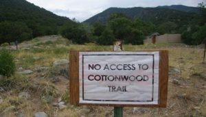
Sign at Greenway’s property just below (west of) Tranquil Way bypass road blockage
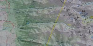
Cottonwood Creek watershed from Sangre de Cristo Wilderness Great Sand Dunes National Park 1:60,000 scale map (2001)

Tranquil Way bypass road, Cottonwood Creek, and Cottonwood Creek trail from Sangre de Cristo Wilderness/Great Sand Dunes National Park 1:60:000 map (2001)
Below are the email messages I have received on this issue since Wendy Maez put me back on the Commissioners Agenda for the August 21 meeting:
9. 8/17/2012 emails from neighbors to Dr. Eric T. Karlstrom re: closure of Tranquil Way Bypass Road
1) Eric,
While not having the pleasure of meeting you, thank you for addressing the access issue.
My/our history with the Baca dates back to 1973 when my sister-in-law and husband built one of the first houses in the development. We bought a lot shortly after that and then a small house in 1979 which I still own.
The time was when folks could travel up most if not all of the creeks in the Baca.
Since my husband passed, I have lived between the Baca and Ft. Collins. We were once avid hikers and jeepers in our area. You probably know it is a nation wide concern.
It is just wrong that the ‘spiritual’ and other stakeholders have closed off access to the upper mountains. What about the rest of us.
I will make every effort to attend your presentation.
Lisa sent me the information.
Thank you again for your efforts; and good luck! And yes you are getting the runaround.
Eleanor Mueller
2) Hi Eric. I regret Julie and I are scheduled to go to Colorado Springs that day. However, I have sent your email to the SCBA (business association) member list and the KCR&GC (gun club) member list. I believe I can at least put together a letter to the Commissioners. Thanks, whf
William Folk PO Box 488 Crestone, CO 81131
finally! I can’t believe it’s taken this long!
Catherine Alelyunas
__________________________________________________________
3) Thank you Lisa and Eric for stating the facts so clearly. I’ll attend the meeting if I can arrange a ride.
Peace & Love, Holly Hosner
4) Eric
Thank you for your action. I too have been upset about this roadway being blocked as it creates a hazard if emergency evacuation is needed. As well, many people have enjoyed this road for years and I did not know it was in violation to close it.
Thank you for your leadership and continued followup of this matter
Kind Regards
Vickie Helm
8/18 emails
5) Dear Mr. Karlstrom,
Thanks for your efforts with the county to re-open access to Cottonwood Trail and the stupa road. Your point about Tranquil Way vs. Overlook or other designation is well taken.
As a member of KTTG with concerns about stupa access, I noted on a map of the Baca subdivision that was until recently hung in the POA meeting hall, that Tranquil Way is, or was, the labelled road to the stupa. I do not reside in the subdivision and so have no legal standing in POA matters, but the question arises as to how and when the Greenways and possibly others were given to understand that they had the right to close that road. If they were told they had that right, even more illegal or questionable activities may have occurred.
Also, FYI, at a POA work meeting some months ago which I attended, the new POA manager was instructed to issue a letter informing the Greenways that their action was in violation of POA regulations, which require a permit for work involving relocating boulders or using heavy equipment. I do not know if that letter was sent nor what, if any response was received.
Bea Ferrigno
18850 County Road 65
P O B 613, Crestone, 81131
6) Steve,
Thanks for forwarding the letter from Eric Karlstrom. I appreciate Mr. Karlstrom’s interest in improving access to the stupa and hiking trails, however, he is unfortunately mistaken in identifying the road that was closed as a portion of the historic road shown on the old maps. I researched this quite a bit a few months ago. After hearing about the old “postal road” connecting the mining towns of Crestone, Cottonwood and Liberty, I looked at the old maps, found the old road and walked it with someone who had actually used the old road in the early days of building the KTTG stupa. That was before the new extension to Tranquil Way was bulldozed across lots 4322 and 4323, ostensibly by Water & San to improve access to their facilities. The old road is clearly visible, both on the ground and in satellite photos, about 200 feet south of the road which was recently closed.
The old road followed the route of what is now known as the “Mine Road”, or the extension of Dreamway from Shumei, in a southeasterly direction, continuing about 200 feet beyond where the current road ends. It is now blocked by a row of boulders, and 50 feet south of the boulders, a mound of dirt about 4 feet high. At the point 200 feet southeast of the current end, it then turns to the southwest and continues parallel to the creek, in the greenbelt between the creek and the Greenway lots, down to a point just behind the Greenway house, where it turns southeast again and crosses the creek. All of the closed portion of the old road lies within the POA greenbelt.
I attach a juxtaposition of two maps to show this. On the left is the 1967 USGS map showing the old road, and on the right in the same scale, a 2011 USGS map which includes satellite imagery. On the satellite image you can see the extension of Tranquil Way which was closed, the Greenway house, and the traces of the old road.
So I do not believe Mr. Karlstrom will be successful in his efforts to force the Greenways to reopen the road, but I am sure that KTTG and/or the Cottonwood Creek group would welcome any positive contributions to either back their proposals or develop other viable alternatives.
Chester Wood
10. My response to Chester Wood’s email message: (8/20)-
Chester is correct that the roads that appear on the 1967 USGS Crestone Quadrangle topo map are different than the road we are referring to here as Tranquil Way bypass road. Thus, apparently, the Tranquil Way bypass road was created subsequently to 1967. However, it was certainly in existence and in use when the Commissioners passed County Resolution 96-G-7 on September 17, 1996. Therefore it qualifies as a historic road and must be treated as such.
Thus, I re-iterate my two main concerns are: 1) The County needs to enforce the existing laws that pertain to land use/historic road changes, and 2) We all need to ensure that there the American people continue to have access to their public lands and waters.

Boulders blocking historic Tranquil Way bypass road, photo taken summer, 2012
11. Comments to the Crestone/Baca Planning Commission Regarding The Possibility of Illegal Blockage of “Tranquil Way Bypass Road” by Dr. Eric T. Karlstrom, 10/3/2012
Comments to the Crestone/Baca Planning Commission regarding the possibly illegal blockage of “Tranquil Way bypass road”
Dr. Eric T. Karlstrom, Emeritus Professor of Geography, Baca resident,
October 3, 2012

(From upper left: detail from 2001 map showing Tranquil Way bypass road joining Baca Grande roads of Chalet II with Dream Way, boulders blocking Tranquil Way bypass road, “No Access to Cottonwood Trail” sign on the Greenways property, and map of Spanish and Cottonwood Creek trails from Roach, G., “Colorado’s Fourteeners.” (1999)
Road and land use issues are now being vigorously debated and disputed all over the West. Individuals and groups often have different visions and expectations for how public roads and highways should be administered and they also have differences of opinion as to what constitutes a “public highway” and a “public road.” These disputes put pressure on our elected officials to make decisions that are fair and legally defensible. So it is especially important to make sure we resolve the issue of the Tranquil Way bypass road issue fairly, as this decision may set a precedent for future decisions.
My specific concerns are that 1) public access to public lands is protected, and 2) the pertinent laws of the land are followed and equally applied to all. Others here have different concerns about the blockage of the Tranquil Way bypass road. Some are concerned about loss of emergency access, some, some about access to the KTTG stupa, and still others are concerned that an unneeded road and parking lot should not be built on POA greenbelt along the south side of Cottonwood Creek near E. Twinview Overlook, etc.
I have climbed all the spectacular peaks that rim the Cottonwood Creek watershed and I know how beautiful the area is. These kinds of wilderness experiences provide more than just “recreation;” for many, they also constitute a form of spiritual experience. Thus, I am motivated to speak for the 300 million Americans who own the Cottonwood Creek surface water and the Cottonwood Creek trail, the Cottonwood Creek watershed, the Sangre de Cristo Wilderness and, indeed, all our public lands. Speaking for these 300 million American citizens are not able to be here to speak on their own behalf, it is of paramount importance that our public lands remain open to our citizens in future generations.
As you know, the approximately 250-foot (80 yard) stretch of road I’m calling the Tranquil Way bypass road” is one of two roads that has, for the last nearly 40 years, provided access to the Cottonwood Creek watershed. It provides a route from the Baca Grande subdivision to Dream Way, Cottonwood Creek, and the KTTG stupa that does not involve driving on the slower, relatively poorly maintained “old mine road” or “Dream Way.” Keeping this more accessible route open is important in case of fire and health emergencies, etc.
In the notebooks provided, I outline the history of the so-called “Tranquil Way Bypass road” in Appendix 1. In Appendix 2, although I don’t claim legal expertise, I reference the laws which I believe are relevant and a law that is not relevant to this particular case. Appendix 3 includes comments that local concerned citizens sent to me.
In Christmas, 2011, the Greenway family or their local surrogates emplaced large boulders on the Tranquil Way bypass road, thus blocking the road and reducing the number of public access roads to Cottonwood Creek watershed from two roads to one. They did this without approval by the Saguache BoCC or the Baca Grande POA. An obvious major concern is that if another individual or group decides now to similarly block the Old Mine Road in that vicinity, there will no longer be any public access to the Sangre de Cristo Wilderness in the area of the Cottonwood Creek watershed.
Specific facts regarding this short segment of road include (from Appendix 1):
1) The “Tranquil Way bypass road” was created in 1975 when the Baca Grande Water and Sanitation District put in a water line and smoothed over the surface of their excavations, thus creating a rough but passable road. Almost immediately, locals, including Eleanor Mueller and her husband, began using this “very rough” road to access the Old Mine Road and our public trails. In a recent email to me, Ellie reports that the “road” was improved shortly after 1975 and that locals continued to use it. She adds that “most of the Baca roads were not in at that time.”
2) Chalet II roads and lots were platted in 1972. However, the “Tranquil Way bypass road” was put in prior to the sale of the lot through which it runs (4323). In November of 1981, the Baca Grande Corporation sold Lot 4323 to Dennis L. and Pamela S. Rosta. No private easement was officially recorded at that time or subsequently.
3) In 1995, the Water and Sanitation District added an electric line next to the water line.
4) In September 17, 1996, the Saguache County Commissioners signed 96-G-7 Reception (No. 316837), making this the effective law of the land. 96-G-7 states that “all public roads located within Saguache County, Colorado that have not been heretofore publicly vacated by the BOCC are hereby designated public highways.” The resolution defines public roads and public highways to include: “highways, roads, mining roads, logging roads, wagon roads, trails, horse trails, hiking trails and footpaths”.
5) The Rostas sold lot 4323 to the Greenway family in 1998. Again, no private easement was officially recorded at that time.
6) In 1999 or 2000, Water and Sanitation paid Randy Robbins of Antonito to improve the road by placing gravel on the surface.
7) The Greenways consolidated three lots (4322, 4323, 4324) to form 4322-C in 2002 from their home in Germany, with Robert Philleo acting as power of attorney.
8) About Christmas of 2011, boulders were placed on the Tranquil Way bypass road, blocking the road.
However, based on Resolution 96-G-7, the Tranquil Way bypass road should be considered a “public highway” or “public road.” When this law was signed the road was in existence, had been in use for 21 years, and had not been officially vacated by the BoCC.
The other law pertinent here is Colorado Revised Statue 30-28-110, which requires private owners to go through a specified 6-step application process, which includes a public hearing with this Planning Commission, to change the land use of “public roads.” A quick perusal of google indicates that many, if not most Colorado counties (including Boulder, Archuleta, Eagle, Rio Blanco) and cities (including Denver, Aspen, Pitkin) adhere to this Colorado Revised Statute.
Colorado Revised Statute (CRS) 3028-110 1(d) states: “The acceptance, widening, removal, extension, relocation, narrowing, vacation, abandonment, change of use, or sale or lease of or acquisition of land for any road, park or other public way, ground, place, property, or structure shall be subject to similar submission and approval (by the planning commission), and the failure to approve may be similarly overruled.”
CRS 30-28-110 defines a “complete location and extent application process” that involves six steps: 1) Complete Application Submittal, 2) Completeness Review, 3) Applicant Revisions for Completeness, 4) Schedule Hearings, 5) Internal/External Review by County Staff and Referral Agencies, and 6) Planning Commission Hearing. Note that the above Colorado statute requires that a specified application must be complete, a public hearing must occur, and the application must be approved by the County Planning Commission prior to a major land use change such as the one that has occurred.
Thus, it appears that the Greenways or their local surrogates violated two relevant laws when they blocked this road. These Colorado laws clearly require that public highways crossing private property must be officially vacated by County officials prior to changing their historic use. The specified public hearing process never occurred.
Clearly, these same laws pertain to other “public highways and roads” that were in use in September 1996 and which had not previously been officially vacated by the BoCC. These include the Cottonwood and Spanish Creek trails and “the Old Mine Road.”
In addition, local resident Bea Ferrigno stated the following to me in an email communication (Appendix 3):
“FYI, at a POA work meeting some months ago which I attended, the new POA manager was instructed to issue a letter informing the Greenways that their action was in violation of POA regulations, which require a permit for work involving relocating boulders or using heavy equipment. I do not know if that letter was sent nor what, if any response was received.”
Several concerned locals have asked me who told the Greenways they had the right to close this road. Perhaps we will all learn the answer to this question today.
I am not a lawyer. But it seems to me that a large part of the confusion here relates to the attempts by some locals and officials to try to apply an antiquated law known as RS 2477.
RS 2477 was enacted by the U.S. Congress in 1866 to encourage settlement of the Western United States and development of a system of highways. The entire text of RS 2477 is one sentence: “The right-of-way for the construction of highways across public lands not otherwise reserved for public purposes is hereby granted.” Note that this law refers to granting right-of-way for highways across “public land,” not private land.
RS 2477 was repealed in 1976 under the Federal Land Policy and Management Act (FLPMA). However, identification of “grandfathered in” “RS 2477” roads has become legally controversial. From Wikipedia: “Private property activists claim that nobody has access rights without a recorded easement. Shared-access activists claim that virtually all private land that used to be public can legally be traversed by the public.” (See Appendix 4 for previous history and related correspondence on these issues).
My Conclusions:
1) Because the “Tranquil Way Bypass Road” had not been officially vacated at the signing of Saguache County Resolution 96-G-7 on September 17, 1996 it should be considered a “public highway” or “public road.”
2) Since this public road crosses private property, Colorado Revised State 30-28-110 requires that the property owners go through a specified application process, as outlined in the CRS, and receive official approval before blocking such a road.
3) These laws have not been followed. Hence, neither the Greenways nor the BoCC are in compliance with the relevant laws of the land.
4) In addition, the Greenways are apparently not in compliance with BG POA covenants and have probably been notified of that fact.
5) Compliance with the relevant laws requires the BoCC to instruct the Greenway family to remove the boulders from the Tranquil Way bypass road within ten days. The property owners then have the right to initiate an application process to legally change the use of that road, as outlined in CRS 30-28-110.
Potential Objections and My Counter-Arguments
1) Objection: Some, such as Scott Johnson, argue that this “road” was never intended to be a road, but rather was only a privately-owned water line and later, an access road for Water and Sanitation District vehicles.
My rebuttal: The water line right of way became a public road when people began using it as a road. And since this “road” had not been officially vacated by the BoCC when they signed 96-G-7 in September of 1996, it therefore qualifies as a “public road.”,
2) Objection: Some, such as Commissioner Sam Pace, argue that a private easement between Water and Sanitation District and the property owners exempts this road from being considered a “public road.”
My rebuttal: Again, after conducting independent searches, both Wendy Maez of the Saguache County Land Use Office and Rebe Hazard of the Saguache County Abstract Company informed me that no such private easement has been officially recorded.
3) Objection: Some, such as Commissioner Mike Spearman, argue that the Tranquil Way bypass road is not a public road because it does not qualify as an “RS 2477” road.
My rebuttal: This argument is a “red herring” and a complete non sequitur. I agree it is not an RS 2477 road. Just as you or I are not “RS 2477 roads.” RS 2477 is antiquated and now repealed law that in the past, applied to public roads crossing public lands. It never applied to public roads crossing private land.
4) Objection: Some, such as Commissioner Mike Spearman and Christian Dillo of the Cottonwood Study Group, have expressed the view that these issues are best resolved through “consensus.”
My rebuttal: In the United States, we live in a system of Constitutional law. The most equitable and legally defensible solutions to these kinds of controversial problems is to be found through application and enforcement of the appropriate county, state, and federal laws. As someone recently said to me: “Consensus just depends on who gets invited to the meeting.” (See Christine Chandler’s letter on this subject in Appendix 4).
12. Appendix 1: Facts regarding the creation, use, and recent closure of the “Tranquil Way bypass road” and legal history of Lot 4323
1) In 1975, the Water and Sanitation District dug a water line downhill from Dream Way just north of Cottonwood Creek thereby initially creating the so-called “Tranquil Way bypass road” (Scott Johnson, personal communication, 2012). According to Steve McDowell (personal communication, 2012), the Water District has a 16-foot wide easement over the water line.
2) In a September 26, 2012 email to me (Eric Karlstrom), Baca resident Eleanor Mueller recalls driving on that road in 1975 with her 1971 VW bus. She recalls that the road was “really rough” but was improved shortly thereafter. Ellie states that “most of the (Baca Grande) roads were not in at that time.”
3) A private easement for the Tranquil Way bypass road was never recorded according to Wendy Maez (Land Use Department of Saguache County) and Rebe Hazard (Saguache County Abstract Company).
4) Lot 4323, which is crossed by the “Tranquil Way bypass road,” was sold by the Baca Grade Corporation to Dennis S. and Pamela L. Rosta on November 20, 1981 (Wendy Maez, pers. comm.).
5) Lot 4323 went to Tax Sale during the Rostas’ ownership of the lot but the Rostas paid back taxes. Thus, the County never actually owned the property during the period of time that the Rostas were owners (1981-1998) (Saguache Co. Abstract Co.).
6) The Water and Sanitation District added an electrical line next to the water line in 1995 (Steve McDowell, pers. comm.).
7) On September, 17, 1996, the Saguache County Commissioners passed Saguache County Resolution 96-G-7 Reception (No. 316837) which states that “all public roads located within Saguache County, Colorado that have not been heretofore publicly vacated by the BOCC are hereby designated public highways”. The resolution defines public roads and public highways to include: “highways, roads, mining roads, logging roads, wagon roads, trails, horse trails, hiking trails and footpaths”.
8) Ulrike Greenway purchased Lot 4323 (the lot with the Tranquil Way Bypass Road across it) from Pamela and Dennis Rosta on March 19, 1998 (Wendy Maez).
9) In 1999 or 2000, the Baca Grande Water and Sanitation District paid Randy Robbins of Antonito to improve the so-called “Tranquil Way Bypass Road “so that they could access their Cottonwood Tank facility more easily (Steve McDowell, personal communication).
10) Saguache County approved the consolidation of lots 4322, 4323, and 4324 on May 14, 2002 (Wendy Maez, Saguache County Land Use Department).
11) Again, a private easement of the Tranquil Way bypass road was never recorded by Saguache County or the Saguache County Abstract Co. prior to the Greenway’s purchase of lot 4323 or the Greenways’ consolidation of lots 4322, 4323, and 4324 in 2000.
12) According to Baca resident Clem Gasseling, a Water and Sanitation District Board member from 1998-2008, states that the Tranquil Way bypass road appears on a duplicate map produced in 1996. The original map is older than that.
History of Sale of Lots 4323, 4322, and 4323 in Chalet II.
1) On Dec. 15, 1976, Baca Grande Corp. sold Lot 4324 to Jon B. and Suzann D. Spain.
2) On Nov. 20, 1981, Baca Grande Corp. sold Lot 4323 to Pamela L. and Dennis S. Rosta.
3) On Jan. 27, 1982, Baca Grande Corp. sold Lot 4322 to Catherine Khagani.
4) On June 6, 1991, Saguache County took possession of Lot 4322 due the fact that back taxes had not been paid.
5) On 3/10/1992, the Greenways obtained a Quit Claim deed for Lot 4324 from Jon B. Spain. They obtained a Warranty Deed from Suzann D. Spain on 4/29/92.
6) On March 19, 1998, Ulrike Greenway purchased Lot 4323 (the lot with the Tranquil Way Bypass Road across it) from Pamela S. Rosta and Dennis L. Rosta.
7) On 10/16/2001, the Greenways obtained a Quit Claim deed for Lot 4322 from Saguache County.
8) On Feb. 18, 2002, Robert Philleo, of Northern Valley Investment and Realty, acted as Power of Attorney on behalf of the Greenways to purchase the three lots, 4322, 4323, 4324. The Greenways were living in Germany at the time and purchase was notorized in Germany on that date. The three lots were consolidated into one lot (422-C) later that year.
9) Regarding lot 4323, Pamela L. and Dennis S. Rosta did not continually pay their taxes between the time they purchased Lot 4323 (November 20, 1981) and the time they sold it to the Greenways (March 19, 1998). However, Saguache County never took ownership of this lot.
Appendix 2: Laws that are relevant and one that is not relevant to the identification and adjudication of “public roads” crossing private land
Relevant laws:
1) Saguache County Resolution 96-G-7 Reception No. 316837, signed on September 17, 1996 by the BOCC states that “all public roads located within Saguache County, Colorado that have not been heretofore publicly vacated by the BOCC are hereby designated public highways”. The resolution defines public roads and public highways to include: “highways, roads, mining roads, logging roads, wagon roads, trails, horse trails, hiking trails and footpaths”.
This county resolution, signed by our Saguache BoCC on 9/17/96, carries the power of state and federal law. It is the “law of the land.”
2) Colorado Revised Statute 30-28-110:
d) “The acceptance, widening, removal, extension, relocation, narrowing, vacation, abandonment, change of use, or sale or lease of or acquisition of land for any road, park, or other public way, ground, place, property, or structure shall be subject to similar submission and approval, and the failure to approve may be similarly overruled.”
CRS 30-28-110 defines a “complete location and extent application process” that involves six steps:
1) Complete Application Submittal
2) Completeness review
3) Applicant Revisions for Completeness
4) Schedule Hearings
5) Internal/External Review by County Staff and Referral Agencies
6) Planning Commission Hearing.
This Colorado Revised Statute requires that an application must be complete, a public hearing must occur, and the application must be approved by the County Planning Commission prior to a major land use change such as the blockage of Tranquil Way bypass road. This law has not been followed. No public hearing has occurred. There has been no formal approval of the land use change. Hence, the BoCC is, in my opinion, legally obligated to instruct the Greenways to unblock the Tranquil Way bypass road until this legal process has been followed and official BoCC approval has been obtained.
The United States is a nation of laws. My reading of these laws suggests a similar approval process would also be necessary prior to closing of other “public roads” that traverse private land in this area. Other “public roads” would include the Spanish Creek and Cottonwood Creek trails, as well as the Old Mine Road or Stupa Road. Because none of these “public roads” were vacated by the BOCC prior to September 17, 1996, each of them qualifies as a “public road.” This means that whoever wants to officially change the status of a “public road” not vacated by the BOCC prior to 9/17/96 must, by law, go through the six-step public application process outlined in CRS 31-28-110.
Laws That Are Not Relevant
3) RS 2477 was enacted by the U.S. Congress in 1866 to encourage settlement of the Western United States and development of a system of highways. The entire text of RS 2477 is one sentence: “The right-of-way for the construction of highways across public lands not otherwise reserved for public purposes is hereby granted.”
Note that this law refers to granting right-of-way for “public roads” across “public land” (not private land).
RS 2477 was repealed in 1976 under the Federal Land Policy and Management Act (FLPMA). However, identification of “RS 2477” roads has become legally controversial.
From Wikipedia: “Private property activists claim that nobody as access rights without a recorded easement. Shared-access activists claim that virtually all private land that used to be public can legally be traversed by the public.”
Hence, since RS 2477 refers to public roads crossing public land it does not apply to the case of the Tranquil Way bypass road. Furthermore, based on the Wikipedia information provided, both private property and shared-access activists would agree with this interpretation.
My Conclusions:
6) Because the “Tranquil Way Bypass Road” was not officially vacated prior to the signing of Saguache County Resolution 96-G-7 on September 17, 1996, it is must be considered a “public road.”
7) Since this public road crosses private property, Colorado Revised State 30-28-110 requires that the property owners go through a specified application process, as outlined in the CRS, to block the road.
8) These laws have not been followed. Hence, both the Greenways and the BoCC are not in compliance with the relevant laws of the land.
4) The BoCC and Cottonwood Study Group are mistaken in their attempts to place this issue under the rubric of RS 2477 for the following reasons:
a) RS 2477 refers to public roads crossing public lands.
b) RS 2477 was repealed in 1976.
c) Although some claims have been made that certain roads, previously classified as RS 2477 roads, are “grandfathered in,” both private property activists and shared-access activists would agree that RS 2477 does not apply in this case because “nobody has access rights without a recorded easement” and “all private land that used to be public can legally be traversed by the public.”
Appendix 4: Pertinent Correspondence
Dear Mr. Dillo: September 25, 2012
As I contemplate your lengthy email to Dr. Eric Karlstrom (September 8, 2012) regarding the issue of the closing of the Tranquil Way Bypass road, what stands out for me is your seeming ‘belief” (shared by many of the CSA leaders and some in this community) that we already live in a place that is now following the rules of ‘communitarianism” and “decision by consensus”, with the “rule of law” being secondary or not considered at all.
Further, your whole email implies that somehow the upcoming “community” meeting of October 3rd between the POA Board, the Planning Committee of the POA, and the BOCC, will build a “consensus” and that this consensus will influence how the BOCC makes it’s decision on the issues surrounding the potentially illegal closure of the Tranquil Way bypass road.
The last time I looked, the BOCC and the BGPOA were still both a group of elected officials, expected to make decisions by following the laws and the statutes of the nation, state, and county.
Your email, however, strongly implies that ‘consensus building,” as an alternative model of government decision-making, is “already a fact.” And as head of a spiritual center which has the tax-exempt status of a ‘church,” you don’t seem to see any conflict in your promoting and implementing this view at the October 3rd meeting of the Saguache County Planning Commission.
However much some in this community may be ‘envisioning a future” whereby decisions are made by consensus, that is actually not the world we live in now. We actually still live in a democracy of elected officials who are expected to obey and implement the laws of the nation, state and county and also to follow their statutes and bylaws, including the bylaws and covenants of the other governing, elected bodies such as the Baca Grande POA.
Despite being a head of a spiritual center, you appear not to see any ‘conflict of interest” in your strong influence and presence on this issue. The blocking of this access road (Tranquil Way bypass road) directly benefits the Zen Center and supports its mission as a contemplative retreat center by keeping ‘citizen traffic’ to a minimum. As I understand it, the Zen center has already put up ‘no trespassing signs” at the base of the Spanish Creek trail, claiming it is ‘private property,” so there is already a precedent that the Zen Center has a vested interest in keeping public trails ‘off limits” to the public. This fact alone would seem to preclude an ‘unbiased’ interest on your part as a representative of the Zen Center.
Further, all so called ‘public forums’ that I have attended in the recent past were, in fact, merely “public relations campaigns”, wherein honest debate was deliberately silenced so that a purposely-controlled ‘consensus” of a minority of so-called “stakeholders” could then prevail in whatever issue is under consideration. Perhaps we need to understand that these “Delphi Techniques” of psychological manipulation of large groups by a few were developed by the Rand Corporation in the 1950’s as form of warfare against target civilian populations.
The October 3rd meeting that you allude to regarding the trail/road closings will more than likely be just another “public relations” event at the POA Hall. “Supporters” of the “Cottonwood Study Group Plan”, aka the “stakeholders” will present what appears to be a “neutrally-mediated position” probably using “non-violent communication techniques” in order to implement a predetermined policy outcome already formulated by these same ‘stakeholders.” This has become a pervasive and common ‘strategy” in the Crestone/Baca of late to push agendas on a community that is unawares of this use of NVC and AI and ‘controlled outcome’ “Delphi Techniques.” Thus, if the October 3rd meeting is anything like what has occurred our community in the recent past, it will be a totally-controlled meeting. Then it will be reported in the Crestone Eagle that the ‘community reached a consensus.” This won’t be true, of course, because approximately 3000 POA members do not live here and will not have had an opportunity to become aware of the issues at stake or to express their opinions or votes. Furthermore, most of the POA members who do live here do not attend POA meetings anymore. (Many ‘causes and conditions” have influenced their non-participation.) Finally, the interests of the approximately 300 million Americans, for whom public access to public land is a fundamental right of their citizenship, will also be completely ignored in this phony “consensus” process.
Again, any non-binding, skewed consensus reached at this meeting in favor of tolerating the potentially illegal closure of public roads and trails cannot be considered to be a legal substitute for elected officials’ following the law. Again, these same tactics were used during the two-year effort of the CrESD directors, the POA Board, and the local spiritual centers to try and force an unneeded Fire District on our community. These groups tried to illegally obtain millions in property and funds to finance the new Fire District, which would have benefitted the spiritual centers with a more firm guarantee of protection. So forgive me if I no longer believe that this meeting that will likely rubber stamp the plan of your Cottonwood Study Group to re-route roads and trails in the area of Cottonwood Creek the road and trailhead closings and will be any different. The only difference is that in this issue, the interests of some of the spiritual centers will be more transparent than with the CrESD issue.
Most taxpayers in this community, this county and this country still believe in the “separation of church and state.” With that in mind, I request that you recuse yourself from having input on this issue, because of your lack of impartiality and your previous investment of time and effort into limiting public access to public lands. You may of course still exercise your right to speak as a single member of the community, albeit one who is not currently an American citizen. It would certainly seem to be an obvious “conflict of interest” for you to be “directing” or trying to influence any part of this decision-making process, including trying to dictate what format it takes. On the contrary, I believe the most constructive policy for our community will be to encourage the proper elected officials to follow the state and county laws that pertain to maintaining public access to public lands via public roads and trails.
Sincerely yours, Christine A. Chandler
Handout 2: Legal history of Lot 4322, 4323, and 4324 (now Lot 4322C)
1) Baca Grande Corp. sold Lot 4324 to Jon B. and Suzann D. Spain on Dec. 15, 1976.
2) Baca Grande Corp. sold Lot 4323 to Pamela L. and Dennis S. Rosta on Nov. 20, 1981.
3) Baca Grande Corp. sold Lot 4322 to Catherine Khagani, on Jan. 27, 1982.
4) Saguache County took possession of Lot 4322 on. June 6, 1991 due the fact that back taxes had not been paid.
5) The Greenways obtained a Quit Claim deed for Lot 4324 on 3/10/1992 from Jon B. Spain for $1. They obtained a Warranty Deed from Suzann D. Spain on 4/29/92 from the Spains.
6) March 19, 1998, Ulrike Greenway purchased Lot 4323 (the lot with the Tranquil Way Bypass Road across it) from Pamela S. Rosta and Dennis L. Rosta.
7) On 10/16/2001, the Greenways obtained a Quit Claim deed for Lot 4322 from Saguache County.
8) Robert Philleo, of Northern Valley Investment and Realty, acted as Power of Attorney on behalf of the Greenways to purchase the 3 lots, 4322, 4323, 4324 on Feb. 18, 2002. The Greenways were living in Germany at the time. Purchase price was notorized in Germany on that date.
9) Saguache County approved the consolidation of lots 4322, 4323, and 4324 on May 14, 2002.
Handout 3: Laws that are relevant and one that is not relevant to the identification and adjudication of “public roads” crossing private land
Relevant laws:
1) Saguache County Resolution 96-G-7 Reception No. 316837, signed on September 17, 1996 by the BOCC states that “all public roads located within Saguache County, Colorado that have not been heretofore publicly vacated by the BOCC are hereby designated public highways”. The resolution defines public roads and public highways to include: “highways, roads, mining roads, logging roads, wagon roads, trails, horse trails, hiking trails and footpaths”.
This county resolution, signed by our Saguache BoCC on 9/17/96, carries the power of state and federal law. It is the “law of the land.”
2) Colorado Revised Statute 30-28-110:
d) “The acceptance, widening, removal, extension, relocation, narrowing, vacation, abandonment, change of use, or sale or lease of or acquisition of land for any road, park, or other public way, ground, place, property, or structure shall be subject to similar submission and approval, and the failure to approve may be similarly overruled.”
CRS 30-28-110 defines a “complete location and extent application process” that involves six steps:
7) Complete Application Submittal
8) Completeness review
9) Applicant Revisions for Completeness
10) Schedule Hearings
11) Internal/External Review by County Staff and Referral Agencies
12) Planning Commission Hearing.
This Colorado Revised Statute requires that an application must be complete, a public hearing must occur, and the application must be approved by the County Planning Commission prior to a major land use change such as the blockage of Tranquil Way bypass road. This law has not been followed. No public hearing has occurred. There has been no formal approval of the land use change. Hence, the BoCC is, in my opinion, legally obligated to instruct the Greenways to unblock the Tranquil Way bypass road until this legal process has been followed and official BoCC approval has been obtained.
The United States is a nation of laws. My reading of these laws suggests a similar approval process would also be necessary prior to closing of other “public roads” that traverse private land in this area. Other “public roads” would include the Spanish Creek and Cottonwood Creek trails, as well as the Old Mine Road or Stupa Road. Because none of these “public roads” were vacated by the BOCC prior to September 17, 1996, each of them qualifies as a “public road.” This means that whoever wants to officially change the status of a “public road” not vacated by the BOCC prior to 9/17/96 must, by law, go through the six-step public application process outlined in CRS 31-28-110.
Laws That Are Not Relevant
3) RS 2477 was enacted by the U.S. Congress in 1866 to encourage settlement of the Western United States and development of a system of highways. The entire text of RS 2477 is one sentence: “The right-of-way for the construction of highways across public lands not otherwise reserved for public purposes is hereby granted.”
Note that this law refers to granting right-of-way for “public roads” across “public land” (not private land).
RS 2477 was repealed in 1976 under the Federal Land Policy and Management Act (FLPMA). However, identification of “RS 2477” roads has become legally controversial.
From Wikipedia: “Private property activists claim that nobody as access rights without a recorded easement. Shared-access activists claim that virtually all private land that used to be public can legally be traversed by the public.”
Hence, since RS 2477 refers to public roads crossing public land it does not apply to the case of the Tranquil Way bypass road. Furthermore, based on the Wikipedia information provided, both private property and shared-access activists would agree with this interpretation.
My Conclusions:
9) Because the “Tranquil Way Bypass Road” was not officially vacated prior to the signing of Saguache County Resolution 96-G-7 on September 17, 1996, it is must be considered a “public road.”
10) Since this public road crosses private property, Colorado Revised State 30-28-110 requires that the property owners go through a specified application process, as outlined in the CRS, to block the road.
11) These laws have not been followed. Hence, both the Greenways and the BoCC are not in compliance with the relevant laws of the land.
4) The BoCC and Cottonwood Study Group are mistaken in their attempts to place this issue under the rubric of RS 2477 for the following reasons:
a) RS 2477 refers to public roads crossing public lands
b) RS 2477 was repealed in 1976.
c) Although some claims have been made that certain roads, previously classified as RS 2477 roads, are “grandfathered in,” both private property activists and shared-access activists would agree that RS 2477 does not apply in this case because “nobody has access rights without a recorded easement” and “all private land that used to be public can legally be traversed by the public.”
Handout 4: Emailed Comments from Other Concerned Citizens
13. Emails to Dr. Eric Karlstrom Regarding the Tranquil Way Bypass Road Issue, Compiled September 28, 2012
1) Ellie Mueller is a property owner in the Baca who has been here a long time- since the 1970’s, hiking the trails with her husband, who has no passed away. She remembers using the road in question as far back as 1975. Here’s what she says:
Eric,
First, thank you for the work you are doing. Second, I can’ make the meeting on the 3rd, have dentist appointment and an environmental meeting in Fort Collins.
Now going back to when I might have first been on the road in question. As best as I can remember, I believe it was 1975. We had a 1971 VW bus and the (Tranquil Way bypass) road was really rough. It was later smoothed out; I don’t remember when because by that time we had a Jeep.
Most of the roads were not in at that time. We used to use the old ‘ranch’ roads. We drove on the railroad bed.
My personal opinion is that it is really stupid to reroute the road because of environmental damage and it sets a very bad, well everything. I can imagine all sorts of issues coming up in the future.
I can’t help but wonder who told them they could close a road.
Good luck! Ellie ____________________________________________________________
2) Carolyn Dailey, Crestone property owner
Dear Erik – Thank you for your efforts in trying to keep the road open that gives access to the Stupa and Cottonwood Creek. Is there any way that a petition could be made on line for people to sign? Would that have an effect? I am a member of KTTG and we have property in Crestone where we visit regularly, though I live in Moab, UT now. The Stupa is a very important and sacred place to me. Innumerable people visit it every day, as I witnessed when I did a 2 month retreat up in one of the cabins 5 years ago. Please keep me informed on this issue and let me know if there is any way I can help. I am also a personal friend of Gerry Roach if it would help to have me ask him if he could get his mountaineer contacts activated…
Sincerely, Carolyn Dailey
____________________________________________________________
3) Rebe Hazard, Saguache County Title Company
(I asked Rebe Hazard of the Saguache County Abstract Company to see if she can find some official private easement documented for lot 4323 prior to September, 1996 (when County Resolution 96-G-7 was passed). Here is what Rebe says in an email communication to meJ
Hi Eric,
Re: Lot 4323 Chalet II, Baca Grande, I find that the above property did go to Tax Sale however the Rostas (owners from 1981-1998) redeemed the property (paid the back taxes). The county never was in actual ownership of the property during the time the Rostas owned the property. I also find no easement was recorded during the time that Rostas owned the property.
Thanks, Rebie
Subsequently, I asked Rebe to try to determine if there was private easement was recorded for this road and prior to the 1981 when the Rostas purchased lot 4323. She told me she could find no such record. Wendy Maez has come to the same conclusion at the Saguache County Courthouse.
______________________________________________________________8/17/2012 emails:
4) Eleanor Mueller, Baca home owner
Eric,
While not having the pleasure of meeting you, thank you for addressing the access issue.
My/our history with the Baca dates back to 1973 when my sister-in-law and husband built one of the first houses in the development. We bought a lot shortly after that and then a small house in 1979 which I still own. The time was when folks could travel up most if not all of the creeks in the Baca.
We were once avid hikers and jeepers in our area. You probably know it is a nation wide concern. It is just wrong that the ‘spiritual’ and other stakeholders have closed off access to the upper mountains. What about the rest of us?
Thank you again for your efforts; and good luck! And yes you are getting the runaround.
Eleanor Mueller
5) William Folk, Baca home owner and President of BC POA Board
Hi Eric. I regret Julie and I are scheduled to go to Colorado Springs that day. However, I have sent your email to the SCBA (business association) member list and the KCR&GC (gun club) member list. I believe I can at least put together a letter to the Commissioners. Thanks, whf
William Folk PO Box 488 Crestone, CO 81131
6) Catherine Alelyunas
Finally! I can’t believe it’s taken this long!
__________________________________________________________
7) Hollie Hosner, Baca home owner
Eric,
Thank you Lisa and Eric for stating the facts so clearly. I’ll attend the meeting if I can arrange a ride.
Peace & Love, Holly Hosner
8) Vickie Helm
Eric,
Thank you for your action. I too have been upset about this roadway being blocked as it creates a hazard if emergency evacuation is needed. As well, many people have enjoyed this road for years and I did not know it was in violation to close it.
Thank you for your leadership and continued follow-up of this matter
Kind Regards, Vickie Helms
8/18 emails
9) Bea Ferrigno, Baca home owner
Dear Mr. Karlstrom,
Thanks for your efforts with the county to re-open access to Cottonwood Trail and the stupa road. Your point about Tranquil Way vs. Overlook or other designation is well taken.
As a member of KTTG with concerns about stupa access, I noted on a map of the Baca subdivision that was until recently hung in the POA meeting hall, that Tranquil Way is, or was, the labelled road to the stupa. I do not reside in the subdivision and so have no legal standing in POA matters, but the question arises as to how and when the Greenways and possibly others were given to understand that they had the right to close that road. If they were told they had that right, even more illegal or questionable activities may have occurred.
Also, FYI, at a POA work meeting some months ago which I attended, the new POA manager was instructed to issue a letter informing the Greenways that their action was in violation of POA regulations, which require a permit for work involving relocating boulders or using heavy equipment. I do not know if that letter was sent nor what, if any response was received.
Bea Ferrigno
18850 County Road 65
P O B 613, Crestone, 81131
14. My Impressions from October 3, 2012 meeting of Crestone /Baca Planning Commission on Cottonwood Creek area access-
by Eric Karlstrom, Baca resident, 10/5/2012
My Impressions from October 3, 2012 meeting of Crestone /Baca Planning Commission on Cottonwood Creek area access-
by Eric Karlstrom, Baca resident
Planning Commission members: Lisa Cyriaks, Kareena ? (Chair), Charlie ?, Clay Bridgeford, Jason Anderson, Matie Belle Lakish, old Libertarian hippie, Jahre ?, and unknown lady.
The meeting was well attended with perhaps 25 – 30 in the audience. Two representatives from the Forest Service were present, David Hozak and Jim Pitts. Elvie Zamorra, Assistant Road and Bridge Manager of Saguache County was also present. Others in attendance include Woodora Rose, Holly Hosner, Steve Smilak, Terryl Tucker, Don Tullos, Bill Folk, Chester Wood, Allison McClure (POA), Jim Sutherland, a representative from a Colorado Mountain Club, etc. Esther Grant wandered in and out at odd times in kind of in a trance or daze. Notable for their absence were the Greenways and a representative from Water and Sanitation District.
Ben Gibbon, lawyer for the Saguache County Commissioners set the stage for the discussion. He began by stating that since the Baca Ranch was formed in 1864 and RS 2477 was passed in 1866 that none of the local roads qualify as a RS 2477 roads. He stated that in order to legally identify a road like the Tranquil Way bypass road as a “public road,” locals would have to go to court to establish a “prescriptive easement“ across private property. He stated it would take a court action to declare this a public road and we would have to prove it was “open, notorious, and adverse” (i.e., adverse to the owner’s interest). He stated that this court action would likely take two years. His recommendation was that we locals would first need to make the case to the county commissioners and then go to court to establish a “prescriptive easement” for the road.
(ETK – Eric T. Karlstrom- rebuttal comment): In my presentation I stressed that RS 2477 was repealed in 1976 and that it refers to public roads crossing public lands, not private lands. So the issue of whether this is or isn’t an RS 2477 road is, I believe, a non sequitur- a red herring, and is brought up to confuse the issue. The legal procedure that Gibbon outlines, in which we locals would need to prove that the Tranquil Way bypass road is a “public road”- assumes first that it isn’t a public road. However, if our local officials applied a law they passed in 1996 (96-G-7), I believe that it would be clear that the Tranquil Way bypass road does qualify as a public road. Thus, as I see it, the nub of the issue is that our County Commissioners are refusing to enforce their own law. (Perhaps we will need to sue them to enforce their own law?) In addition, the procedure that Gibbon outlines is exactly the opposite of what is called for in another Colorado law. CRS 30-28-110 outlines the process by which private property owners are required to submit an application for a land use change of a pre-existing road. So again, the resolution of the problem depends upon 1) getting Saguache County Commissioners to enforce their own laws, and 2) determination of whether Tranquil Way bypass road is a “public road”).
Following Gibbon’s introductory remarks, three of us made presentations on the topic of the Cottonwood Creek area access.
9) I (Eric Karlstom) gave the first presentation, reading from a prepared statement. I distributed 7 notebooks of text, maps, photos, appendices, etc. which I had prepared to the Planning Commissioners. Again, I made the case that the law that applies here is not RS 2477, which was repealed in 1976, but rather 96-G-7 (No. 316837) which the Saguache County Commissioners passed in September of 1996. 96-G-7 states: “all public roads located within Saguache County, Colorado that have not been heretofore publicly vacated by the BOCC are hereby designated public highways.” The resolution defines public roads and public highways to include: “highways, roads, mining roads, logging roads, wagon roads, trails, horse trails, hiking trails and footpaths”.
I also outlined the history of the Tranquil Way bypass road: It was established in 1975 when the Water and Sanitation District excavated a water line, thereby producing a “very rough” road that locals immediately began using it as a route to access Dream Way and our public trails along Spanish and Cottonwood Creeks. I stressed the importance of maintaining this road as an open road for access to Cottonwood Creek trail and watershed and also the KTTG stupa. I also cited CRS 30-28-110 that mandates that any private land owner that wants to change an existing land use, such as blocking a road, must go through a specified 6 step process that involves a public hearing.
Hence, I made the case that the Greenway’s closing of the Tranquil Way bypass road was a violation of two Colorado and Saguache County law, specifically 96-G-7 and CRS 30-28-110. I suggested that it was the legal responsibility of the BoCC to instruct the Greenways to remove the boulders and initiate the prescribed application process (as per CRS 30-28-110) if they still wished to close the road.
10) The next speaker, Zoey DeBray’, who is director of the KTTG stupa, outlined the KTTG stupa projects’ preferred option of creating a new access to the stupa by purchasing land just north of the Greenways to build an new access road. In order to actually bring this plan to completion, however, KTTG would have to go through many different steps. They would need to persuade the owners to sell the ladn, they would need to raise the funds to purchase the land, they would need to get permission from the POA to cross a stretch of POA greenbelt, they would need create a public easement so that the public could use the road, and they would need to get the county to agree to take over the maintenance of the road. (Currently, the county only maintains Camino Baca Grande).
(ETK comment and rebuttal): In our question and answer period, William Folk, who is president of the Baca Grande POA, noted that a 67% vote of approval from all POA members would be required in order to change the POA covenant which disallows roads or paths on green belts. In my opinion, this fact alone, renders the DeBray and Dillo’s plans unworkable. There are also many other hurdles and potential “deal breakers” that could derail this plan. Thus, it might not be realized in less than two years, if at all.
3) Christian Dillo of the Cottonwood Study Group (CSG) and Crestone Mountain Zen Center then outlined the CSG plan to re-direct access to the Cottonwood trail by securing land along POA greenbelt on the south side of Cottonwood Creek. They, or more accurately, the U.S. Forest Service would then install and maintain both a foot trail and a parking lot. People would hike up to “Dream Way” and then jog north to the Cottonwood Trailhead.
(ETK rebuttal): Again, in later discussion, Bill Folk, President of the POA pointed out that 67% of the POA membership would have to vote in favor of this plan in order for the POA to over-ride its own covenants that prohibit construction on a greenbelt. Hence, this plan is not a seriously workable plan either. Also, in so many words, Dillo acknowledged that the CSG and their sponsor, the Manitou Foundation, are going under the assumption that by virtue of Manitou Foundation’s ownership of a strip of land they have the legal power to close off public access to Spanish Creek and Cottonwood Creek trails as well as Dream Way. Many in the audience, including myself, disputed this assumption based on 96-G-7, in particular.
Like the DeBray plan, the CSG plan would tie things up for at least 2 years, in which there would be essentially no access to Cottonwood Creek trail. Whereas the DeBray plan is meant to maintain access to the Stupa only, the Dillo plan is meant to provide access to Cottonwood trail. However, until about last Christmas when it was blocked by boulders, the Tranquil Way bypass road provided access to both the Stupa and Cottonwood Creek. It almost seems as if these two plans together are designed to cut off access to the Cottonwood Creek area during the next two years.
During the polite but rather obtuse and surreal discussion that followed (surreal because often people did not seem to be hearing each other very well) some good points were brought out. I here emphasize comments and interchanges that I found significant. (Although I use quotation marks, these are NOT direct quotations but rather my recollection of what was said. To determine direct quotations would require listening to a taped version of the meeting, which may exist.)
Planning Commissioner Charlie ? quizzed me on whether the Tranquil Way bypass road meets the criteria of a county road, that is, has a 60-foot right of way and a grade of less than 8%. I said I didn’t think so. Later in the discussion, Assistant Road and Bridge Manager, Elvie Zamorro pointed out that there are many “grandfathered in” roads in Saguache county that do not have 60-foot rights of way and/or had gradients steeper than 8%.
(ETK note: I find Charlie’s questions to be quite disingenuous. He was trying to leave an impression of discrediting the idea of Tranquil Way bypass being a road by selective application of facts).
Bill Folk: Before Bill left the meeting temporarily, he stated to me, (and I paraphrase): “The real culprits here are the County Commissioners who refuse to enforce their own laws.” I asked if I could make that comment for him publically and he said please do and use my name and use the word “culprit.”
Don Tullos also left the meeting early and also left this comment with me to make to the Planning Commission (again I paraphrase): “When a public trail exists before people buy the land over which it crosses, that trail continues to exist as a public trail in perpetuity.”
(ETK comment: This is what 96-G-7 mandates).
Bill Folk returned and stated his opinion that: “It would be impossible to get the 67% approval vote of POA members needed to implement the Cottonwood Study Group plan.”
Near the end of the meeting, Christian Dillo, in my opinion, dropped somewhat of a “bombshell” when he stated: About three years ago, the Greenways offered to allow an alternate road to be built on their property at the northern edge of their lot next to the LaVey(?) family. However, that family objected and the Greenways have subsequently retracted this offer. This offer is no longer on the table.”
(ETK comment: Dillo had indicated in his presentation that the timing of the Greenway’s blockage of the Tranquil Way bypass road was a mere coincidence and just happened to coincide with the efforts of the CSG. In other words, he suggested that there had been no collaboration between he, the CSG and the Greenways. However, this comment seems to indicate that indeed there had been communication and coordination of activities between Dillo (from Germany) and the Greenways, who (Germans).
Charlie (Commissioner): Added to Dillo’s revelation that about three years ago, he had stood on the Greenway’s property when the Water and Sanitation was ready with a bulldozer to put in this new, lower gradient road on the northwest corner of the Greenway’s property. He added this information: When the Greenways tried to go through the POA approval process to get permission to build this new road, their neighbors’ objections scuttled the plan. He speculated that the Greenways might possibly be convinced to reconsider this plan.
(My comment: Had this plan been implemented three years ago none of us would have needed to waste all this time with this issue. It would have been solved back then. These comments near the end of the meeting indicated to me that Charlie ? and Dillo have considerably more knowledge about the history of these issues than they have given the public.)
Jason Anderson asked: “What is the situation at the Cottonwood Trailhead. Is there sufficient parking space and tourists?”
Eric Karlstrom answers: “Yes there is room for at least 11 cars as well as a porta poddy at the trailhead.”
David Hozak (US Forest Service) confirmed Karlstrom’s statement, indicating that, at USFS request, the Water and Sanitation District had constructed a temporary parking lot near the Cottonwood Creek trailhead designed to accommodate 10 to 12 cars. Hozak: “We have an agreement with Water and Sanitation that they will permit public parking at the Cottonwood trailhead until the end of this year. So we need to find a solution to this issue before the end of the year.”
Steve Smilak: “It seems that there is an order of events that has to happen here. C can’t happen unless B is implemented and B can’t be implemented until A is approved, etc. It seems to me that the closing of Tranquil Way was an egregious violation of law. So let’s start with that and determine whether or not the closing of Tranquil Way bypass was legal or illegal. Then and only then can consider these two other plans.”
Jim Sutherland: “Since it is a benefit for the entire community for the public to have continued access to the stupa as well as the Cottonwood Trailhead, perhaps the community should find some way to help pay the costs of maintaining that access.”
Eric Karlstrom comment to Planning Commission: “There are two approaches: “If it ain’t broke don’t fix it, and If it ain’t broke, fix it till it’s broke.” When the Greenways placed those boulders they created a problem where there had been no problem before. Now we are offered “solutions” to this created problem that are much worse than the original state of things. In computer studies, there is a rule called “Garbage In, Garbage Out” that says your conclusions can be no better than your assumptions. If your assumptions are wrong your conclusions are going to be wrong. Manitou’s assumption that they have the right to close public roads and trails that existed before they acquired their land is an erroneous assumption. And this erroneous assumption has produced a lot of problems.”
Jason Anderson: “We need to make a decision and not drag this issue out any longer. We need to start somewhere. So let’s start with finding out if the closing of Tranquil Way bypass road was legal or not. Until we determine that, it doesn’t make sense to make any decisions on these other plans.”
(ETK comment: Right on, Jason, you get it.)
Lisa Cyriaks: “There are so many aspects to this and so much information has been presented here. So let’s take this up at another meeting within the next couple weeks and try to summarize what we’ve learned. Then we can decide what the next step is.”
Wendy Maez: “Is that a motion?”
Lisa Cyriaks: OK, I make that a motion.
The motion carried.
(ETK comment now): Note that if Jason Anderson had turned his comment into a motion, then the Planning Commission would actually be addressing the legality of the closing of Tranquil Way bypass road. And I, at least, would feet like I succeeded in getting the Planning Commission to address the proper issue- the closing of Tranquil Way bypass road. However, Jason’s comment did not get turned into a motion for action. Instead, Lisa Cyriaks moved the process in a more diffuse and nebulous direction. This was somewhat of a disappointment for me at first. However, Lisa later explained that if the Planning were to make a recommendation on the legality of the closing of the Tranquil Way bypass road to the current board of county commissioners, they would be unlikely to act in a constructive manner. Apparently, Lisa’s recommended strategy now is to try to continue to mobilize community support for keeping access open to the Cottonwood Trailhead and stupa and revisit the issue at the November 7 meeting. (I’m scratching my head here).
My impression now: It was acknowledged that I, as independent citizen researcher, have the right now to return to the Saguache County Commissioners and request action on this issue.
Many of these individuals such as Charlie of the Planning Commission, have much more experience with this issue than they have acknowledged.
In addition, the fact that the Water and Sanitation will not provide parking access at Cottonwood Trailhead after s 31, 2012, suggests that deals will have to be made in the future to even keep this access open. This will occur regardless of which plan is implemented:
1) Greenways are asked to remove boulders.
2) KTTG begins trying to create alternative road to Dream Way.
3) Cottonwood Study Group will begin trying to implement their plan to have the USFS build and maintain a footpath and parking area on the south side of Cottonwood Creek.
Again, I note the absence of any Water and Sanitation personnel at this meeting. Water and Sanitation built and maintained the road. What is their stake in this? We know that:
1) In about 2009, there was a major purge of qualified locals who had run Water and Sanitation since its inception in the 1970’s. At that time, Water and Sanitation contracted out the management of its operations to a special water district (Special District Management Services) in the Denver area.
2) Water and San board members are now pushing hard to purchase a water right from the federal government’s Baca National Wildlife Refuge.
3) If public access to Cottonwood Creek is blocked off in the near future, could it be easier for Manitou Foundation and/or Water and Sanitation District to secure a surface water right at that location?
4) Based on 120-year old Colorado water law, surface and subsurface water rights are integrated into a model.
(ETK speculation: Does the deliberate apparent limiting of public access to Cottonwood Creek area relate to designs by some private corporate interests to gain a firmer legal ownership of water rights that could relate, in the near future, to control of San Luis Valley groundwater?)
Final comment: Tyrell Tucker (to me, ETK, at lunch after meeting): “Property values in Crestone/Baca are the lowest in the states. This is in large part due to the fact that our County Commissioners don’t enforce the laws and because people here hate the POA.”
15. Petition Of Baca Residents To Remove Boulders From Tranquil Way Bypass Road; 10/20/2012
Petition to Remove Boulders from Tranquil Way Bypass Road
We, the undersigned, regret the sudden closure of the Tranquil Way bypass road, which until recently, provided one of two main public access routes to Cottonwood Creek trail, Cottonwood Creek watershed, Cottonwood Creek, and the Tashi Gomang (KTTG) stupa. We feel that closure of this road places some 50 to 75 homes in the southern part of the Baca Grande community, particularly, at greater risk in case of fire and/or other emergencies. Reduced access to the Sangre de Cristo Wilderness Area and the four spectacular“14ers” of this part of Wilderness Area also adversely impact recreational and economic benefits to our community. Unauthorized blockage of this public road may be illegal. Two Colorado and Saguache County laws require that a specified public process must be followed prior to closure of “public roads:”
1) Saguache County Resolution 96-G-7 Reception No. 316837 states: “all public roads located within Saguache County, Colorado that have not been heretofore publicly vacated by the BOCC are hereby designated public highways”. “Public roads” are defined as: “highways, roads, mining roads, logging roads, wagon roads, trails, horse trails, hiking trails and footpaths”. This law was passed by the Saguache Commissioners on September 17, 1996.
2) Colorado Revised Statute (CRS) 30-28-110 1(d) states: “The acceptance, widening, removal, extension, relocation, narrowing, vacation, abandonment, change of use, or sale or lease of or acquisition of land for any road, park or other public way, ground, place, property, or structure shall be subject to similar submission and approval (by the Saguache County Planning Commission), and the failure to approve may be similarly overruled.”
Therefore, we believe it is the responsibility of the Saguache County Commissioners to enforce their own laws and require the Greenway family to remove the boulders from the Tranquil Way bypass road until they complete the required public application process, as defined in CRS 30-28-110 above.
Name Address Date
____________________________________________
16. Letter From Dr. Eric T. Karlstrom, 11/3/2012
To whom it may concern, Nov. 3, 2012
My personal history with the Tranquil Way bypass road and this issue
I purchased three lots in Chalet I in the Baca Grande subdivision in 1994. In the 1980’s, I had visited the area to climb in the Sangre de Cristo Wilderness Area. I climbed Crestone Peak in 1986, Crestone Peak and Crestone Needle in 1995, and four unnamed “13ers” in the Cottonwood Creek watershed in 1999. To access these peaks, I used the Cottonwood Creek trail. While building my house in 2000 and 2001 and since then up until about December, 2011, I frequently used the “Tranquil Way bypass road” as a means to access the Cottonwood Creek trail and the KTTG stupa.
In about December of 2011, while walking to the KTTG stupa, I observed that the Tranquil Way bypass road was blocked by large boulders. Although concerned, I did nothing at that time, hoping that others in the community would respond to this apparent illegal closing of a commonly used and much needed public road. Until that time, a sign located on the corner of Tranquil Way and Camino Baca Grande just north of Cottonwood Creek said “Stupa” and had an arrow pointing uphill, directing traffic up Tranquil Way and the Tranquil Way bypass road to Dream Way.
Last summer, when it became apparent to me that no one else in the community was going to address the issue of the possible illegality of the Greenway’s closing of the Tranquil Way bypass, I requested an audience with the Saguache County Commissioners. In my presentation to the Commissioners on August 21, 2012, I asserted that the closing of the Tranquil Way bypass road was apparently a violation of two County and State Laws (96-G-7 and CRS 30-28-110). At that time, the County Commissioners deferred the matter to the Crestone/Baca Planning Commission who were to take up the issue on Oct. 3, 2012. At that meeting, I made another presentation.
History of Tranquil Way bypass road and my conclusions to date:
1) The approximately 80-yard segment of road in question was created in 1975 when the Baca Grande Water and Sanitation District ran a water line downhill from Dream Way into Chalet II just north of Cottonwood Creek.
2) This path/road was used by locals in 1975 as a road to access trails in the National Forest (see Ellie Mueller’s notarized message.)
3) When it was created in 1975, this water line/road traversed private land owned by the Baca Grande Corporation. (Thus, RS 2477, which pertains to public roads crossing public land, has never been applicable to this road. The entire text of RS 2477 refers to one sentence in an 1866 mining law (“the right-of-way for the construction of highways across public lands not otherwise reserved for public purposes is hereby granted.”). RS 2477 was repealed in 1976 under the Federal Land Policy and Management Act (FLPMA).
4) The Tranquil Way bypass road was improved several times by the Baca Grande Water and Sanitation District, most recently in 1999/2000, so they could access their Cottonwood Tank.
5) On November 1, 1981, the Baca Grande Corporation sold Lot 4323 to Pamela S. and Dennis L. Rosta.
6) On September 17, 1996, the Saguache County Commissioners passed Resolution 96-G-7 (No. 316837), which states that all roads on private land that had not been vacated by this date were to be regarded as “public roads.” As per that date (9/17/96), no private easement for the Tranquil Way bypass road had been recorded with Saguache County or with the Saguache Abstract Company, according to Wendi Maez and Rebe Hazard, respectively.
7) On March 31, 1998, the Rostas sold Lot 4323 to Ulrike Greenway, a German citizen. No private easement had been recorded when this purchase was made and the road had then been in public use for 23 years.
8) In 2002, Ulrike Greenway consolidated three lots, (4322, 4323, and 4323) into one lot (4322-C).
9) In 2006, Greenway built a house on a dirt road that is shown on the 1967 USGS Crestone 7.5 minute quadrangle map. Constructing a home on this “public road” without going through the public process required in Colorado Revised Statute (CRS) 30-28-110 was probably a violation of the same two laws (Resolution 96-G-7 and CRS 30-28-110) as their subsequent blockage of the Tranquil Way bypass road.
10) In about July, 2011, Greenway and her partner, Reiner Schumacher-Greenway, placed small rocks and boulders on the Tranquil Way bypass road, attempting to keep the public from using the road. They did not post a “No Trespassing” sign.
11) Soon thereafter, Crestone/Baca resident Marvin Ogden, who often used that road to access the KTTG stupa, began removing the rocks from the Tranquil Way bypass road. According to Ogden, the Greenways ran out of their house, shouting, cursing, and insulting Ogden. Reiner Schumacher-Greenway threatened to have Ogden arrested for trespassing. Ogden replied that the Greenways did not have the right to close a public road, and that only county officials could do that.
12) About Christmas of 2011, the Greenways or local surrogates had large boulders placed on the Tranquil Way bypass road, effectively closing the road. The Greenways did not go through the legal process required by Colorado law (CRS 30-28-110) to close a public road.
13) Despite direct and repeated appeals by local citizens, the Saguache County Commissioners have not yet notified the Greenways that they have violated two local county and state laws and therefore must remove the boulders until such time as their proposed land use change is approved by the Crestone/Baca Planning Commission, under the terms laid out in CRS 30-28-110.
Salient Issues:
When the Greenways closed the Tranquil Way bypass road, they created some very serious problems were for our community.
1) Blocking of the Tranquil Way bypass road removes the only emergency exit route southern in the southern portion of Chalet II that is available to fire fighters and other emergency responders. Thus, the Greenways’ action limits the ability of emergency responders to protect citizens’ lives. Local Fire Chief Ben Brack has stated that without an emergency exit he would probably not jeopardize his fire crew or fire equipment by responding to a fire in that area (see Clem Gasseling’s statement). Rio Grande National Forest Fire Management Officer Jim Jaminet, has also stated that “It would be desirable from an emergency evacuation perspective to have the Tranquility Way Bypass as an open route” (see statement by Jim Jaminet). Hence, by closing off the Tranquil Way Bypass road without county approval, the Greenway’s action now places some 50 to 75 homes in southernmost part of the Chalet II at increased risk of fire damage and destruction.
Reiner Schumacher-Greenway stated to the County Commissioners at their October meeting that prior to closing the Tranquil Way Bypass he had checked with Fire Chief, Ben Brack. He claims that Brack told him that in the event of fire, fire fighters would be able to remove the boulders in ten minutes and then procede put out the fire. Similarly, when Jim Jaminet, Fire Management Officer of the Rio Grande National Forest, consulted interested locals, he was told by Matthew Crowley of the Shumei Institute that in the event of a fire emergency locals could call the Shumei Institute and that Shumei personnel would remove the boulders within 10 minutes with the truck they use to clear snow. Both of these statements are patently ridiculous. Jim Jaminet, Fire Manager Officer of the Rio Grande National Forest, has submitted a statement to this Planning Commission in which he states:
“Upon inquiry I have a basic understanding of the situation including property owner desires, a mention that boulders could be quickly moved in the event of a wildfire to allow egress, etc. I have seen and experienced the confusion when emergency evacuations take place in the face of flame fronts with poor visibility due to smoke and then with the added factor of adrenalin. Having only a single way in/out can result in multiple problems. Emergency equipment is trying to get into an area while residents are trying to get out of an area which generates confusion and may result in traffic congestion and accidents that then stop all motor vehicle movement. Having roads blocked by boulders may cause an additional issue of confusion. It would be desirable from an emergency evacuation perspective to have Tranquil Way Bypass as an open route.”
I also have been a fire fighter with the U.S. Forest Service. When there is a fire, every second counts. In Crestone/Baca, it is common knowledge that a house here will be probably consumed by fire within 20 minutes. I seriously doubt that if a fire emergency occurred in this area that the equipment needed to remove the boulders could be employed and the boulders removed in less than one to three hours. Furthermore, locals here are well aware that those who make phone calls to the Shumei Institute have a very high (90+%?) probability that they will contact someone who does not speak English!
So essentially, by closing the Tranquil Way Bypass road, the Greenways have created a needlessly dangerous situation for a large number of individuals and families who reside in the southern part of the Baca community. And by failing to enforce their own laws, the Saguache County Commissioners are enabling, aiding, and abetting this unnecessarily dangerous and illegal situation.
2) Access to the Cottonwood Creek trail and watershed is now reduced. The Greenways now have a sign posted on their property that states “No Access to Cottonwood Trail.”
The persistent attempts by the Manitou Foundation as well as their allied spiritual groups, community members, and sympathetic political figures to limit public access to the Rio Grande National Forest and the Sangre de Cristo Wilderness Area are extremely disturbing to me. We Americans are a tolerant and generous people. But we will not tolerate attempts by foreigners to wrest control of our valued land and resources or their attempts to limit public access to our public land. This is the issue that is most important to me, personally, and I will continue to do what it takes to preserve public access to public land in this spectacular natural area.
3) Laws are now being violated and very bad precedents are being set. Blockage of the Tranquil Way bypass road, a “public road” as defined in County Resolution 96-G-7, is a violation of the law of the land. The Greenways apparently also broke the law in 2006 by building their home on an older “public road.” This older road is shown on the 1967 USGS Crestone 7.5 minute Quadrangle map.
4) The two “solutions” being offered by the Cottonwood Study Group and the KTTG stupa project to solve the “problem” created by the Greenway’s closure of the Tranquil Way bypass road are unworkable. William Folk, current President of the POA Board, has pointed out publically that both proposals would be impossible to implement because they 1) require the building of new roads on POA greenbelts and 2) a 67% majority of POA members would have to approve this overriding of POA covenants and restrictions. This has never happened in the past.
Because these proposals cannot be implemented under present POA rules without the imposition of “eminent domain” by County officials, it is very unlikely they can resolve any of above problems.
5) If they have not already done so, County officials will probably soon recognize the very real threat to public health and safety that has been created by the closure of the Tranquil Way bypass road. If they decide to support the Greenways’ closure of Tranquil Way bypass road, they will probably need to intervene and declare “eminent domain” in order purchase land that is currently POA greenbelt. The legal review process required to enforce “eminent domain” on land currently designated as POA greenbelt could be quite time consuming, expensive, and a waste of tax-payer money.
6) Thus, the easiest and cheapest solution for County officials is to obey the laws of Colorado and Saguache County. This requires they instruct the Greenways to remove the boulders on the Tranquil Way bypass road until such time as they have gone through the public process outlined in and required by CRS 30-28-110.
17. Letter from Baca Resident, Marvin Ogden, To Saguache County BOCC and Others Regarding Tranquil Way Bypass Issue, 11/3/2012
To whom it may concern, Nov. 3, 2012
I came to the Baca Grande in 1995 and purchased 4.5 acres in the Grants. A friend and I were investigating the area, the hiking paths, and the spiritual centers at that time, and I definitely recall using the Tranquil Way bypass road. The road was passable at that time.
Since then, I have used the road regularly many times during the year, mainly to go up to the KTTG stupa.
In about July, 2011, as I was descending the Tranquil Way bypass road from Dream Way in my truck, I noticed that tiny rocks had been placed across the road. I assumed that kids had put the rocks there. So I got out of the car to move them. At this point a woman came running out of the house nearby followed by a man. Now I know that the woman was Ulrike Greenway and the man was her partner. This couple has their main residence in Germany and they stay in their Crestone home about one or two months of the year.
…. She yelled at me in a loud angry voice: “This is our land, you have no to right trespass on it.” My response was: “I don’t see a sign that says no trespassing.” The man, also yelling, said: “You dumb son-of-a-bitch! I’m going to have you arrested for trespassing and I’m going to call the Sherriff.” I replied: “You can’t vacate a road unless you have the County Commissioners do it first. It doesn’t matter whether it’s private land or public land. As long as a road has been used for twenty years or more, which this road has been, then it is a road and it’s owned by the county.” At this point, the man, still yelling, called me a dumb son-of-a-bitch again and took my lisence plate numbers, and again threatened to call the police and report me.
Then I went home and I called the Sheriff’s office and talked to Sheriff Mike Norris. He said: “I’ll take care of this, don’t worry about it.” And I have never heard back from him or anyone else.
Marvin Ogden
17576 County Road 71
Crestone, CO 81131
18. Minutes from November 5, 2012 meeting of Saguache Board of County Commissioners, in which Commissioners Vote that there has not been enough evidence presented to designate the Tranquil Way Bypass a public road
Saguache County Board of Commissioners met in regular session Monday, November 5, 2012 with the following present:
Mike Spearman, Chair
Sam Pace, Co-Vice Chair
Linda Joseph, Co-Vice Chair
Wendi Maez, Co-Administrator
Lyn Lambert, Co-Administrator
Ben Gibbons, County Attorney
Staci Morfitt, Acting Secretary to the Board
Meeting called to order by Chair Spearman at 9:10 A.M.
Employee Appreciation:
No employees at this time.
Joseph moved to approve the agenda as amended. Pace seconded the motion. The vote was three Ayes.
Additions or Deletions to the Agenda:
-
- Road & Bridge Supervisor will not be present today.
Pace moved to approve the minutes of October 15, 2012 as amended. Linda Joseph seconded motion. The vote was three Ayes.
Reading and approval of minutes of October 15, 2012:
Pace moved to approve the Steel Horse Liquor License, pending no protests at the Public Hearing. Joseph seconded motion. The vote was three Ayes.
Review of Mail and other correspondence:
-
-
- 1. Rio Grande Water Conservation District sent the October 2012 Ground Water Table Measurements. (10/22/12)
- 2. State Board of Equalization sent notice of the public hearing for the State Auditors on October 25, 2012 at 1:00p.m. Saguache County is listed with unresolved reports from the Assessment Auditor for Residential properties for 2009, 2010 and 2011. (10/22/12)
- 3. Daniel S. Johnson sent the October 2012 report for the Saguache County Fire Mitigation Program. (11/1/12)
- 4. CTSI sent notice of board positions that are up for election. If anyone is interested a letter of interest is to be received by CTSI no later than November 12, 2012. (10/31/12)
- 5. The Colorado Department of Public Health and Environment sent notice that the Air Quality Control Commission does not plan to meet on November 15, 2012. The next scheduled meeting will occur December 20, 2012. (10/31/12)
- 6. The Colorado Department of Public Health and Environment sent a correction plan approval with conditions for the Saguache County Landfill. (10/24/12)
-
Introduction of Guests:
Matie Belle Lakish- Crestone Eagle Perry Hazard- private citizen
Sandra Montoya- RGWCD
Beverly DeGani-High Valley Church
Galen DeGani- High Valley Church
George Whitten Jr. – RGWCD
T. Roger Perry- Perry Farms
Dee Greeman- MV Agribusiness LLC
Katherine Faz – Great Sand Dunes
Lisa Carrico – Great Sand Dunes
Ashley Martinez – Great Sand Dunes
Andrew Archuleta – BLM
Phillip & Ameille Hooper – Steel Horse Grill
Public Comment:
No Comment at this time.
Commissioners Report:
Mike Spearman reported:
-
-
-
- October 18- Attended the Veterans Response meeting with Senator Udall. State Veterans office attended to address some concerns on local medical procedures. All in agreement and contracts in process.
- October 22- Attended the Valley Commissioners Meeting. Gave report on the Veterans Response meeting. All counties brought up to speed on HCP implementing agreement.
- October 22- Attended DRG Board meeting with Mike Wisdom.
- October 25-26- Extension meeting in Denver.
- October 31- Meeting with the Solar Reserve Attorneys. Testifying on November 6 for Public Utilities Commission on renewable energy.
-
-
Linda Joseph reported:
-
-
-
-
- October 17 – Attended the Gunnison Sage Grouse Conservation Strategic Committee meeting in Gunnison, along with alternate, Elinor Laurie.
- Attended the Saguache County Tourism Council meeting for member orientation and introduction of potential members – Matie Belle Lakish and Kairina Danforth.
- October 18 – Attended the Veteran’s conference at Adam’s State Student Union, along with grant writer Susan Pierce.
- October 22 – Attended the SLV County Commissioners Association budget meeting in Alamosa.
- October 23 – Met with Emergency Manager Jim Felmlee and grant writers, to review the OEM budget and fundraising needs.
- Attended the Leadership Luncheon at the Moffat School.
- Assisting Susan Pierce with applicability of grants found in research.
-
-
-
Sam Pace reported:
-
-
-
-
-
- October 23- Site visit to Solar Reserve project near Tonopah, Nevada.
- October 31- Talked with Roni Wisdom about ruling from state on WIB (Workforce Board) issue.
- Took call about sub-district taxes.
-
-
-
-
Wendi Maez; Lyn Lambert – Co-administrator report:
-
-
-
-
-
-
- The County has 2 wrecked vehicles parked in the vacate lot outside of the courthouse. Would like to have the vehicles sold or removed if possible. If possible would like to contact a company that hauls vehicles away and see if they will haul them away. Attorney Gibbons advised to get releases from insurance company first.
- Maez; Lambert attended the SLV COG meeting on October 29, 2012.
- Lambert received a summons from Ron Briggs for court issue on Nov. 20, 2012. Summons is for the BOCC and a copy was sent via email to the BOCC. Attorney Gibbons is working on this for the County.
- Discussion concerning adopting a “fire arms” policy for all employees. Attorney Gibbons working on this.
- Public Trustee Report presented for review and approval.
-
-
-
-
-
Break
Wendi Maez – Land Use Administrator:
Joseph moved to approve the Thomas Roger Perry Revocable Trust and Marilyn Wendi Perry Irrevocable Trust Subdivision Exemption. Pace seconded motion. The vote was three Ayes.
-
-
-
-
-
-
- Thomas Roger Perry Revocable Trust and Marilyn Wendi Perry Irrevocable Trust – Subdivision Exemption request – SW1/4 11-41-7. The location of this request adjoins the Mennonite Church located on County Road E west of Highway 285.The request is to create 3 Tracts – Tract 1 – 148.94 acres, Tract 2 – 5.03 acres and Tract 3 – 3.56 acres (county road right of way). Tract 2 will be purchased by the High Valley Mennonite Church for the use of future parking at this time. Any other use will require a Conditional Use permit. The Saguache County Planning Commission recommended unanimous approval of this request at their regular meeting on October 25, 2012.
-
-
-
-
-
Pace moved to approve the Resolution 2012-G-7 for the Implementing Agreement for the San Luis Valley Habitat Conservation Plan. Joseph seconded motion. The vote was three Ayes.
-
-
-
-
-
-
- Sandra Montoya – SLV Habitat Conservation Plan discussion on the SLVHCP Implementing Agreement. Stated Rio Grande, Costilla, and Conejos Counties have signed the agreement. Asked the BOCC if they would sign on. BOCC discussed along with local landowner Perry Hazard, who is against the agreement, and George Whitten, representing the Rio Grande Water Conservation District, who is for the agreement. Attorney Gibbons advised the BOCC they would need to approve a resolution to sign the agreement.
- Discussion concerning the adoption of a Model Resolution for National Flood Insurance Program in order to be eligible for grant funding thru FEMA and CWCB rules must be adopted by January 14, 2012. A copy of the resolution will be sent to Attorney Gibbons for his review prior to Monday’s meeting.
- Discussion on the Leach Airport and the title search. Attorney Gibbons will work on a contract
-
-
-
-
-
Ben Gibbons- County Attorney:
-
-
-
-
-
-
-
- Marks Litigation- Having information copied for ES&S review.
- Motorcycle accident litigation has been completed.
- Board of Equalization meeting on November 15th, will be attending with Assessor Stephens.
- Ron Briggs filed a civil case and CTSI referred it to a law firm for their review.
-
-
-
-
-
-
Pace moved that after reviewing Attorney Gibbons’ memo to the Board there has not been enough evidence presented to show that the road in question was a public road in 1996. Spearman seconded the motion. The vote was two Ayes. Joseph recused herself due to her affiliation with Manitou and the Cottonwood study group.
-
-
-
-
-
-
-
- Discussion on the Cottonwood area.
-
-
-
-
-
-
Pace moved to enter into Executive Session at 11:40 A. M. for personnel purposes under CRS 24-6-402(4) (f) (I). Joseph seconded the motion. The vote was three Ayes.
Pace moved to adjourn Executive Session and return to regular meeting at 11:48 A.M. Pace seconded the motion. The vote was three Ayes.
Pace moved to convene as the Housing Authority Board at 11:49 A.M. Joseph seconded the motion. The vote was three Ayes.
Evan Samora-Housing Director:
Pace moved to return to regular session at 11:55 A.M. Spearman seconded the motion. The vote was three Ayes.
Lunch
Public Lands: Lisa Carrico and Kathy Faz- Great Sand Dunes National Park and Preserve:
-
-
-
-
-
-
-
-
- Fair number of staff turn overs at the Park.
- First planning stages for a native fish project. Should be a three year project.
- Management Plan for park focusing on the Elk and Bison within the boundaries of the Park.
- Wide range of programs inside and outside of the Park for all ages.
- 232,000 visitors at the Park this year.
-
-
-
-
-
-
-
Andrew Archuleta reported on;
-
-
-
-
-
-
-
-
- Solar PEIS is complete and an applicant still moving forward. No protests on the Geo-thermal EA at this point.
- Incredibly dry. Gave the BOCC a thank you for working so well with the different agencies.
-
-
-
-
-
-
-
Break
Steel Horse Grill: New Liquor License
-
-
-
-
-
-
-
-
-
- See above for motion.
- Public Hearing, no protests and BOCC confirmed approval of this new Liquor License.
-
-
-
-
-
-
-
-
Bill Paying
Spearman moved to adjourn at 2:45 P. M. Joseph seconded the motion. The vote was three Ayes.
Adjourn
Respectfully Submitted,
Staci Morfitt Acting Secretary to the Board of County Commissioners
Minutes Approved November 20, 2012
_____________________________
Chairman of the Board
______________________________________________
Attest Commissioner
18. November 17, 2012 (Email correspondence)
Here are some of the main events in the history of the creation, usage, and illegal blockage of the Tranquil Way bypass road in Chalet II, Baca Grande subdivision.
1975– Baca Grande Water and Sanitation put in a water line down into Chalet II from the Dream Way area just north of cottonwood Creek (Scott Johnson).
1975– locals, such as Ellie Mueller immediately used the road to access the US Forest Service national forest trails (Ellie Mueller, notarized statement)
1981– November 1, Baca Grande Corporation sells lot 4323 to Pamela S. and Dennis L. Rosta (your own documents)
1996– Sept. 17, County Commissioners pass Resolution 96-G-7 which states that roads that have not been heretofore officially vacated are “public roads”
1998– March 31, Ulrike Greenway purchases lot 4323 from Rosta family. The Tranquil Way bypass road had traversed this lot for over 20 years when they made the purchase. No private easement had been recorded.
1999-2000 – Baca Grande Water and Sanitation paid Randy Robbins of Antonito to improve Tranquil Way bypass road- making it just as good as other Baca roads.
2006– Ulrike Greenway builds a home on a dirt road just north of Cottonwood Creek on their 4322-C (formerly lot 4324). This itself may be a violation of the same two laws (96-G-7 and CRS 30-28-110) as the blocking of the Tranquil Way bypass road by boulders in 2011. The contractor who built this home is a local builder named Tehan and the architect was Ann Louise Baker, who is associated with the Crestone Mountain Zen Center.
2011– July, Marvin Ogden, a Crestone/Baca resident who had been using the Tranquil Way bypass road for at least seven years, begins to remove small boulders that the Ulrike Greenway and her partner placed on Tranquil Way bypass road. The Greenways confront Marvin, an argument ensues with the Greenways cursing at Marvin Ogden and telling him to get off their property.
2011– December, about Christmas time, Ulrike Greenway and her husband/partner place large boulders on the Tranquil Way bypass road, blocking all access to Dream Way and Cottonwood Creek trail and the KTTG stupa from what had been known locally as the “stupa road”- Tranquil Way and Tranquil Way bypass road.
Kimberly additions to put this into POA Board context:
January 2012 – Christine Canaly of Baca Grande Water and Sanitation District and Greenways sign easement agreement in an apparent attempt to claim the right to a portion of Tranquil Way currently owned in common by the Baca Grande POA. This easement document (provided at November 16th Board Meeting) does not have legal standing because it did not involve a review and approval/disapproval process with the POA Board. To date, the POA Board has not signed off on this.
January 2012 – Action taken to place boulders blocking Tranquil Way illegally with no approval from the Baca POA architectural committee or POA Board.
November 2012 – POA Board has failed to act on behalf of the Membership to date regarding protecting the property values, safety, and welfare of the POA membership, as explicitly laid out in the articles of incorporation for the Baca Grande POA.
November 2012 – Research may confirm that this unilateral act (which excludes the POA approval) within the administrative boundary of the POA constitutes an ongoing violation of the Membership protective covenants and bylaws.
19. Update on Tranquil Way Bypass Road Issue by Concerned Baca Residents to Saguache County BOCC by Dr. Eric T. Karlstrom 12/4/2012
Board of County Commissioners Dec. 4, 2012
Saguache County
Update on Tranquil Way bypass road issue by Concerned Baca Residents;
Eric Karlstrom, spokesman
I made a presentation to you at August 21 BoCC meeting to explain why many of us in the Crestone/Baca community believe the unauthorized closing of the so-called “Tranquil Way bypass road” is illegal. At that time, the County Commissioners deferred the matter to be considered by the Crestone/Baca Planning Commission at their Oct. 3 meeting, At that meeting, after hearing my statement as well statements from Zoe Debray of KTTG and Christian Dillo of the Cottonwood Study Group, the Crestone/Baca Planning Commission deferred the matter again until their next meeting on November 7. On November 7, several others and I provided notarized statements and evidence to prove that the so-called “Tranquil Way bypass road” has long met the definition of a public road. The notarized statements presented to Wendi Maez at that time included statements by:
1) Ellie Mueller. “Our/my first use of the road in question was 1975 in our 1971 VW camper bus. The road was really rough. Tranquil Way was later smoothed out. By that time we had a Jeep…. There were very few roads in place….. In my humble opinion, closing, moving, etc., the right away sets a very concerning precedent for political, environmental, and emergency services reasons.”
2) Clem Gasseling. Clem quotes local Fire Chief Ben Brack as telling him that “he has informed the people that if he received a fire emergency call in that area, he may not be able to respond because he can not endanger his firemen and equipment with no available escape route.”
3) Eric Karlstrom. I stated I have personally used Cottonwood trail as early as 1986 and have often used the Tranquil Way bypass road for at least the last 12 years. I stated that while hiking I noticed the boulders blocking the road, either December 2011 or January, 2012. These dates, 1975 and 2012, then, provide the brackets for the time period, about 37 years, in which the public has used this road adversely to the interests of the property owners.
4) Marvin Ogden. Marvin stated that he “definitely recalls” using the “Tranquil Way bypass road when he was investigating the area with a friend in 1995 (or 17 years ago). “The road was passable at the time. Since then, I have used the road regularly many times during the year, mainly to go up to the Stupa.” He states that in July, 2012, he noticed small rocks on this bypass road and got out of his car to remove them. Mrs. Greenway “came running out of the house nearby followed by a man. She yelled at me in a loud angry voice, ‘This is our land, and you have no right to trespass on it.’ My response was: “I don’t see a sign that says no trespassing.” The man, also yelling, said “You dumb son of a bitch! I’m going to have you arrested for trespassing and I’m going to call the Sherriff.” I replied: “You can’t vacate a road unless you have the County Commissioners do it first. It doesn’t matter whether it’s private land or public land. As long as a road has been used for twenty years or more, which this road has been, then it is a road and it’s owned by the County.”
5) Frank McGregor. Frank states he has been using this road since 1998. He noted that “the closure of this road creates a variety of “negative impacts” related to a) access to a public water source (emergency access in case of fire), b) loss of secondary evacuation route for retreat centers from Dreamway Road (fire exit), and c) reduced access to Cottonwood Creek drainage hiking trail.”
6) Fire Management Officer, Jim Jaminet, who staed there needs to be a well-considered evacuation plan and “it would be desirable from an emergency evacuation perspective to have the Tranquility Way bypass as an open route.”
We also submitted a petition with 9 signatures that calls on the County Commissioners to enforce the laws of the land and require the Greenways to remove the boulders from the road until they have completed the legal public vacation process required in CRS 30-28-110. We submitted this documentation to Wendi Maez at the Nov. 7 meeting. However, at the conclusion of the Nov. 7 meeting, Wendi Maez read the following resolution that the County Commissioners had made two days prior, on Nov. 5, 2012:
“Commissioner Pace made a motion that after reviewing Attorney Gibbons memo to the Board there has not been enough historical information presented showing proof that this is a public road – motion seconded by Commissioner Spearman – vote two ayes. Commissioner Joseph recused herself due to her affiliation with Manitou and the Cottonwood Study Group.”
This resolution seems to leave the door open for local citizens to provide the needed historical evidence to prove this is a public road. We provided that documentation at the Nov. 7 meeting and I am providing it again today. And we will continue to present the evidence and facts demonstrating that this is a public road.
Legal council recently informed two of us that the law which pertains here is CRS 43-2-201 (Public Highways) that states:
“The following are declared to be public highways: (c) All roads over private lands that have been used adversely without interruption of objection on the part of the owners of such lands for twenty consecutive years.””
This comes under the heading of Prescriptive Right-of-Way. A 2009 legal document by H. Keith Corey, PLS 13466 (970-244-1896) entitled “Road Right-Of-Way” states:
To establish a public highway across private property a party must show that (1) the public used the road under claim of right and (2) in a manner adverse to the landowner’s property interests; (3) the public use was uninterrupted for 20 years; and (4) the landowner had actual or implied knowledge of the public’s use and made no objection to such use. The public’s right results in an easement.
Our legal council points out that the Cottonwood and Spanish Creek trails are subject to this same 20-year statute and therefore are also public roads. Hence, the claim of the Manitou Foundation and Cottonwood Study Group that Manitou has the right to give permission for the public to utilize these public trails is erroneous and illegal. This should be clarified by the County Commissioners for all parties, especially public and the U.S. Forest Service.
Again, at the Nov. 7 meeting and again today we are providing documentary evidence that the public has used this road for 20 years. Although CRS 43-2-201 is the appropriate law to determine a public road through adverse possession and public use, the County Attorney has repeatedly brought up RS 2477, a 19th century mining law that was repealed in 1976. Because this law refers to public roads across public land, we believe that reference to this law is essentially a “red herring” and serves mainly to confuse the issues. In my previous meetings with the BOCC and the Planning Commission, I cited two other laws that apply here. These are 96-G-7 (No. 316837) and CRS 30-28-110. And I documented then that no official easement had been recorded by previous owners when the Greenways purchased lot 4323 in 1998, when the road had already been used by the public for over 20 years.
I would now like to add the following relevant information:
7) In 2006, the Greenways built their house on an old public road shown on the 1967 USGS Crestone 7.5 minute quadrangle map. Constructing a home on this “public road” without going through the public process required in CRS 30-28-110 seems to be a violation of the same three laws (CRS 43-2-201, Resolution 96-G-7 and CRS 30-28-110) as their subsequent blockage of the Tranquil Way bypass road.
8) In January, 2012, two easement agreements between the BGWS and the Greenways were recorded at Saguache County. These documents are an apparent attempt to claim the right to a portion of the Tranquil Way bypass road that is currently owned in common with the Baca Grande POA. These easement documents may not have legal standing because they did not involve the required review and approval/disapproval process with the POA Board. To date, the POA Board has not signed off on these agreements. Research may confirm that this unilateral act (which excluded POA approval) within the administrative boundary of the POA constitutes an ongoing violation of the Membership’s protective covenants and restrictions.
9) In these two agreements (370911 and 370912), the BGW&S and the Greenways granted easement agreements to each other. Whereas the Greenways purchased their easement agreement for $10, the BGW&S purchased their agreement for $5000. However, both of easement agreements may be null and void because the road in question met qualifications for a public road even before the Greenways purchased lot 4323.
10) Meryl Ennis sent out on email on Dec. 3, 2012, in which she stated that local Baca residents of the Serene Way area met on Dec. 2 with Zoe of KTTG. “The main result is that none of the people are in favor of a new road being cut to the upper old mine road. We were all in favor of visitors to the Stupa using the old mine road which KTTG has a permanent ease way from Manitou.”
11) Although the Greenways stated they intend to replace the boulders with a locked gate for emergency access purposes, this has not been done as of the present time. So the increased fire danger to the approximately 50 to 75 homes in the southern portion of the Baca development remains.
Although the Greenway family later stated they intend to replace the boulders with a locked gate, this has not been done as of the present time. So the increased fire danger to the approximately 50 to 75 homes in the southern portion of the Baca development remains.
Hence, the net result of the unilateral and illegal closing of the Tranquil Way bypass will probably remain the same for some time. These negative impacts are: 1) laws are being violated and bad precedents are being set, 2) there is increased risk of fire danger to some 50 to 75 homes in the southern Baca subdivision because of the closure of this road, which served as an emergency access road, 3) there is reduced public access public land, in particular, to the Cottonwood Creek trail, the Cottonwood Creek watershed, nearby forest, as well as the Cottonwood Tank.
Thus, we feel that taxpayers of Saguache County and the citizens of this country will be best served if the County Commissioners enforce the appropriate laws (CRS 43-2-201 and 96-G-7) and require the Greenways to unblock the road until such time as they have gone through the public process required by CRS 30-28-110.
20. 12/3/2012- email correspondence to Dr. Eric T. Karlstrom concerning Tranquil Way Bypass Issue
I drove past the Spanish Creek trailhead this morning and stopped to “meditate” on the irony of how Roshi Richard Dudley Baker (Head of Crestone Mountain Zen Center) could justify a spiritual path of “no body, no mind…no attainment, with nothing to attain…” while simultaneously attempting to block Spanish Creek Trail from all others by asserting “my trail, my creek, my land…”.
Speaking of trails, one thing I find curious is what exactly happened with the “Save Our Trails” “group”.
21. What On Earth Happened To Our Crestone/Baca Community? Dr. Eric T. Karlstrom’s Timeline of Events and Speculations 12/3/2012
I am re-reading my own article: Green Global Dictatorship, Agenda 21, Sustainable Development and the Wildlands Project, etc.. (http://www.waterwatchalliance.us/ch11.html) In my printed version, the map “Biodiversity and Wildlands Project is on page 13 (interesting coincidence). This is the so-called “Agenda 21 map of Death” written by wildlife biologists who feel that human population needs to sharply reduced to “save” nature. This is bullshit, actually, without scientific basis. Talk about divide and conquer. You get a large segment of the population to want to eradicate most everyone else on the basis of pseudo-science!!!!!

You can get better copies of this Wildlands Project map on some websites. Anyway, our area in southern Colorado is mostly red, as you notice, which represents the “core reserves” which are to be devoid of all human use. So this could be why they are deliberately driving people out of here! Other websites, derived from the Wildlands Project website, show that Wildlands Conservation Planning Efforts are active and ongoing in southern and central Colorado. (http://www.restoringamerica.org/wildlands_project_map.htm).

Here (below figure) is their coordinated institutional strategy: (from my article mentioned above). Notice the “Implement Eco-spiritual Strategy Locally”!!!!!!! That’s what Manitou is about- that, and controlling people’s minds through spiritual/cult-like conformity pressure, etc. Meanwhile, Manitou keeps trying to implement all their own eco-plans – conservation easements, etc.- which dovetail nicely with Agenda 21, of course.

Figure 1. Linkages between the UN, IUCN, WWF, WRI and federal agencies and environmental groups, from Dr. Coffman, “The Greening of America” (from my article on Green Global Dictatorship above)
Looking back, I now realize that our community may have been subject to a coordinated (UN Agenda 21) attack in 2008 and 2009- and before and after too of course- but especially then. Here’s how it played out:
1) The Great Sand dunes National Park (a UN World Heritage site and member of IUCN- International Union for the conservation of Nature) proposed a northern entrance to the Park (all stake holders invited). Our Crestone community spent 2 years fighting this.
2) Then our Community was mobilized and seduced/controlled by the Sonoran Institute when they came to “help” us deal with our issues. They set up lectures/workshops/ had us form groups etc (Delphi technique used) to look at this issue.
3) The Crestone Spiritual Alliance became a major player in land use issues.
4) At one of the Sonoran Institute meetings, there is a “rumor mill” period- someone casually announces that Lexam has plans to drill in our valley.
5) Sonoran Institute then coordinates a series of meetings on the Lexam proposal wherein all the stake holders- government, industry, activists, etc. try to tell us – the public- that we can’t win so our best bet is just to help them write the “Best Management Practices.” Lots of milk and cookies were served by Sonoran Institute- the usual Crestone volunteers showed up to organize it and help pull it off.
6) I became part of a group that wrote the “Best Management Practices” that the Baca National Wildlife Refuge (also a member of the IUCN) sent to the state Colorado Oil and Gas Commission, which basically does the bidding of the oil and gas industry. (Basically, our community activists did the work of the Baca national Wildlife Refuge).
7) Meanwhile, the newly formed Baca national Wildlife refuge (staffed by one person!) has no management plan and completely accepts everything that Lexam’s lawyers want them to approve. In other words there was no EIS and originally, not even an EA (Environmental Assessment). It was under the Bush administration and oil and gas controlled government and about that time, there was the big drugs and sex scandal in the Denver area with government and industry officials, etc..
8) About this time, there was a purge of the Water and San employees (Lisa and Chris Canally were on the board)- and they drove Steve McDowell out- he’s the guy with knowledge and knowhow to run Water and San- and they drove water engineer, Deb Phenecie, out)- and then they hired Special District = SDMS – out of Denver area- to manage it. (Another Special District is formed- Hammersmith was first)
9) Then, Dillo and Tamar and the Crestone Spiritual Alliance group that was ostensibly working on the Park northern entrance, blocked off the five trailheads- without asking or telling anyone.
10) Then Bill Folk and Lisa Cyriaks formed the Save Our Trails group ostensibly to keep the trails open. But they cited the wrong laws.
11) Then County attorney Ben Gibbons cited the wrong law (RS 2477) and on this basis, Sam Pace is quoted in the Center Post Dispatch as saying “it would be pretty hard to go against legal advice”- (the legal advice was that since the trails (Cottonwood, Spanish, etc) were not RS 2477 roads, the county did not have the authority to keep them open).
12) Actually the whole RS 2477 thing is a total red herring. And Gibbons tried to use it again this year, re: the closing of the Tranquil Way bypass road, saying, essentially, our hands are tied, it’s not an RS 2477 road.
To continue the saga, the Greenway family, from Germany, had purchased their lot near Cottonwood Creek trailhead in 1998. At that time, the Tranquil Way bypass road had been used to access Dream Way since 1975 (so more than 20 years needed to be a public road)- and there had been no private easement recorded with the county. In 2006, they built their home on another even older “public road” (which was on 1967 USGS map) that crossed their land. This violated at least three state, county and federal laws. The architect was the German princess, Ana Louse (Baker now)- Then in Jan. 2012, the Water and San purchased an easement for $5,000, and signed an agreement with the Greenways. The Greenways immediately blocked the Tranquil Way bypass road. This violated the same three laws.
All this apparently is to block off public access to the Manitou Foundations- Manitou Preserve, which is shown on Manitou maps. Manitou claims to have a conservation easement on this tract (right next to the forest service Baca Mountain Tract)- and it is earmarked for “no human use”- just like the red core reserves in the Wildlands Project map.
So this is creeping Agenda 21 communism with coordinated baby steps (for now) by the various stakeholders- under all kinds of UN arrangements formed by Maurice Strong and the UN since 1945!!!!!!! Fabian socialism, out of England, is just communism in slow motion. And these guys have certainly worked in slow motion!!!!! There’s never a dull moment in “Morberry”- that’s a combination of Mordor and Mayberry!
22. Items For POA Work Session (2/7/2013) presented by Dr. Eric Karlstrom, Emeritus Professor of Geography, CSUS; 2/7/2013
Items for POA Work Session (2/7/2013) presented by Dr. Eric Karlstrom, Emeritus Professor of Geography, California State University.
Regarding the issue of the closure of Tranquil Way bypass road by the Greenway family in January, 2012, I would like to submit the following new information:
1) Two maps shown in an April, 2005 Crestone Eagle article entitled “Manitou Institute: Spirit and Nature” include:
a) The first map (“Manitou Habitat Conservation Program- Mountain Tracts”) shows the approximately 300-yard strips of Manitou-owned land immediately surrounding Willow, Spanish, and Cottonwood Creek designated as “Manitou Preserve.” This map also indicates under the heading “Under Conservation Easement” that the Manitou Preserve areas (dark gray) are to have “NO Development,” whereas areas with spiritual centers (light gray) are to have “limited development,” and two other designations also specific restrictions, “General Development” areas (including Chamma Ling and Vajra Vidya spiritual centers) are limited by “Total Permitted sq. ft. build out = 1%, and “Special Use Zone” is “Allowed development determined on a case-by-case, site specific basis.
b) The second map (“Properties Owned or Conveyed by Manitou, in relation to the greater Baca Grande”) shows all Manitou land as dark gray (Under Conservation Easement) and also shows that the area just north of Cottonwood Creek and just west of “Dream Way” is POA Greenbelt.
The Eagle article states:
“Over the last 17 years, some 750 acres have been granted or sold by Manitou, and approximately 950 acres remain. Of this, about 350 acres will stay in Manitou’s stewardship, under a conservation easement as Preserve (NO development). Another 150 acres, designated as Limited Development (allowing one small solitary retreat cabin per 20 acres), is the home of Manitou’s Solitary Retreat Hermitage Program. Two cabins have been built, and five more are permitted.
In the MHCP, the best and only locations for the more active purposes of the spiritual and educational centers were identified as General Development areas, with maximum building and use parameters pre-determined. The allowable sq. ft. build-out is 1% of that of the property, with a total disturbance area (for parking, trails, utilities, etc.) capped at 15%. At present, Manitou has five larger parcels (35+ acres), four smaller parcels (3 – 24 acres) and a few Baca Grande lots remaining for granting or sale, some under conservation easement and others not.
Acquiring land from Manitou is a rigorous process, and an estimated 90% of those approaching Manitou for land are screened out by themselves or the process, a discernment by both that often takes a year or two. They begin with a Pre- Application outlining their intentions for use of the land. Manitou staff screens these for a possible match, and the vast majority are ruled out due to unsuitable plans for this locale.
The Manitou Board reviews Pre-Applications that appear to fit with its mission and the carrying capacity of the land, and invites full applications from those that seem promising. The full application requires a much deeper level of details and long term planning, and there is considerable attrition of applicants at this phase, as well. The Board, with input from Manitou’s E&A Committee reviews the style, profile and substance of applying projects in making its final decisions of which land grants they approve.
In accepting ownership of Manitou land, grantees and purchasers become partners with Manitou, working collaboratively on development and environmental stewardship plans, and any mitigations required to minimize the impacts of human activities and optimize the health and safety of the land. Grantees submit annual reports to Manitou staff, and the E&AC completes planning and site visits to monitor and support development and land use in alignment with the approved purposes of the land grants, or terms of sale, and the requirements of conservation easements.
Other partnerships have arisen from time to time to address issues of our area as a whole. An early special project, was a collaboration with the Crestone/Baca Land Trust in it’s formative years, Go Colorado Fund, the Baca Grande POA and The Nature Conservancy, which now holds an easement preserving sensitive wetlands in the Grants, that were previously lots to be developed. It took several years, and was achieved by the diligence and hard work of many individuals and organizations.
In Present Time; for the Future
Manitou’s mission of supporting the cultivation of spirit and the preservation of nature is in its second decade, and the Baca is in its third. As the Manitou properties and the Baca Grande grow and develop, we have no end of opportunities to proactively re-create and co-create a healthy community – socially, environmentally and spiritually. It’s not always easy, the vision is unique and the lessons are many. The more individuals and families, spiritual centers and educational projects that make the Baca their home, the more compelling it becomes to find cooperative ways to communicate and to live and work together.
Overcoming mistakes of the past, facing the obstacles and issues of the present with creativity, and designing the future to our mutual benefit – it is a tall order! But, it’s worth every effort in exchange for the joys and benefits of living here, in this unique and amazing place of spirit and nature.
4) Now the issues become more clear to me: It seems that re: the issue of land-use designations, Manitou Foundation has attempted to usurp the functions of local government. It has apparently enlisted the aid of our local agencies and officials (Baca Grande Water and Sanitation District and the Baca Grande POA Board and the Saguache County Commissioners) to allow them to bypass (and break?) the federal, state and county laws that these same agencies are supposed to uphold. Manitou Foundation is a non-profit organization. It does not have the legal authority to make land use designations via conservation easements without going through the legal approval processes of Saguache County or the Baca Grande Property Owners Association.
5) I now believe the Greenway’s (or was it BGW&S?) unilateral and illegal closure of the Tranquil Way bypass road is an example of how the Manitou Foundation operates unilaterally in our County and community, bypassing, and therefore often breaking, federal, state, and county laws.
My conclusions are as follows:
I) The Tranquil Way bypass road was put in as a water line in 1975 but has been used by the public for some 37 years (only 20 is required to qualify as a public road under CRS 43-2-201). This approximately 80-yard connecting segment between Tranquil Way and Dream Way was heavily used by the public between 1975 and 2012 as a way to access the southern portion of Dream Way, the Cottonwood Creek trail and drainage area that access the Sangre de Cristo Wilderness Area and several spectacular 14er and 13er peaks, and the Tashi Gomang Stupa.
II) The 80-yard road segment traverses not only Greenway property but also BGW&S property and POA greenbelt. No easements were recorded for this road until January, 2012, at which point BGW&S and the Greenways sold each other easements which may not be legal. However, the POA Board and the E&AC seem not to have been involved in granting variances for this road.
III) The following state and county laws have not been upheld by local officials. These include:
1) CRS 43-2-201 (the “Public Highways” law):
“The following are declared to be public highways: (c) All roads over private lands that have been used adversely without interruption or objection on the part of the owners of such lands for twenty consecutive years.”
2) Saguache County Resolution 96-G-7 – also defines public roads as roads used by the public that have not been officially prior to 1996.
3) CRS 30-28-110 mandates that a 6-step public process be followed before changing a land use such as blocking a public road.
Notes from Community Meetings: Notes/minutes from 11/10/12 meeting at Woodora’s house re: Cottonwood Creek access,
On 11/7/12, Woodora sent out this email that was sent to her by Kimberly Dawn Kromer, Baca property owner and resident of Estes Park:
“I’ve been doing some research on the Cottonwood Creek Trail issue, and I’ve discovered this relates to a much larger issue of the parcel of land bordering the Baca to the west. With legislation being proposed to sell off federal public land on the state and federal dockets, it is becoming clear that this entire strip of federal land west of the Baca may be at risk of being closed off to public access, with Cottonwood Creek being just the tip of the iceberg.
I’ve been in touch with the Rio Grand National Forest representatives including David Hosack and Gerard Sandoval regarding public access to Rio Grand National Forest. I annotated an old map I found and highlighted in green the full area of federal land in question. Cottonwood creek may be a symptom of something much larger, and the green section of land you see below represents the land you may be ending up defending for public access. I can’t emphasize enough how critical it is that people identify this entire section of land adjoining the BACA as federal public land which must be incorporated into Rio Grand National Forest for the public good. If not, it may be lost to private interests, and then access may be completely cut off (not just to the public at large) but to the entire BACA community as well. Kimberly”
In this email, Kimberly is referring to the “Baca Mountain Tract” of the US Forest Service(in green in below map), located immediately east of the Baca subdivision, which is located between the Baca Grande subdivision and the Sangre de Cristo Wilderness Area.
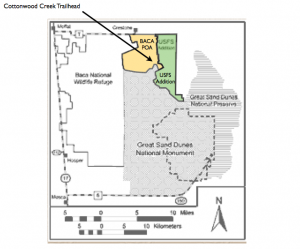
Kimberly and her husband, Chris Jones, own a lot in the Baca. They are activists in the Estes Park area, where they claim they are also trying to “preserve public access to public land” there.
Kimberly, Woodora, Clem Gasseling, Marvin Ogden, and I (Eric Karlstrom) met at Woodora’s place for a coffee this morning (11/10/12). These notes can informally serve as minutes of our meeting.
Kimberly has a great wealth of ideas and good energy and brings new life to our burned-out little cadre. Some information and some ideas brought up at the meeting:
1) The Baca Mt. Tract land (in green in above map) was purchased by public funds.
2) Yet this tract of federal land is on a short list of federal land parcels that could be taken over by the state of Colorado and auctioned off to the highest bidder if certain proposed legislation becomes a reality.
3) Amendment 6 of the US Forest Service Plan, according to Kimberly, does not show that the USFS has a plan for this tract of land, and yet it was required to develop such a plan by 2007.
4) If privatization of this public land tract occurs, we, the public, could lose all access to the N. and S. Crestone Creek, Willow Creek, Spanish Creek and Cottonwood Creek trails and watersheds. Hence, we could lose access to the Sangre de Cristo Wilderness area from this area. Several classic “14ers,” (Kit Carson and Challenger Peaks, Crestone Peak and Crestone Needle) are accessed from Willow, Spanish and Cottonwood Creek trails on the west side of the Sangre de Cristo Mountains. People come from all over the world to climb these peaks.
This new information and perspective gives a broader context for the Greenway’s blocking of the Tranquil Way bypass road. It also could help explain why Manitou operatives closed off 5 trailheads in this vicinity in 2008. Spanish Creek trail still has a No Trespassing sign posted by the Crestone Mountain Zen Center.
How can our community protect ourselves and other Americans from losing our public access to public lands? How can we get the Greenway family from Germany to remove the boulders that they placed on the Tranquil Way bypass road, thus creating greatly increased fire and emergency danger for residents in the southern part of Chalet II?
Our recent experience is this: Our group’s appeals to the Saguache County Commissioners and the Crestone/Baca Planning Commission have been without success…. Thus far, we have failed to persuade the Commissioners to enforce their own laws and order the Greenways to remove the boulders from the 80-yard segment of public road known as the Tranquil Way bypass road.
What other administrative bodies have jurisdiction here? The US Forest Service and the POA.
Ideas for Immediate Action
We identified several avenues of action:
1) Since the Greenway’s blockage of the Tranquil Way bypass road endangers POA property owners and was itself a violation of POA covenants and restrictions, the POA Board is in violation of it’s own charter by not enforcing these covenants and restrictions. A single POA member can file a complaint by writing a letter. And Colorado law requires that this complaint be addressed. This letter should outline the public safety issues created as well as the appropriate bylaws violated. In addition, many POA members agree that the most recent election involves fraud. Hence there perhaps are several grounds to recall the present POA board. This letter should DEMAND the recall of the POA board. We can also DEMAND the removal of the boulders from the Tranquil Way bypass and DEMAND that the POA bill the Greenway’s for costs.
2) If we are successful in generating a recall election and replacing the POA board members with individuals concerned about “public access for public lands,” (our new name?) they could have the boulders removed immediately.
3) (As an intermediate step, it might be useful to try to get BGCAN, Diane Dunlap, and Bruce McDonald involved in this effort. Bruce maintains a website for BGCAN and Diane has experience in past successful recall efforts.)
4) We could ask for assistance from techno-savvy neighbors (Bruce McDonald) to form a website (modeled on Kimberly’s “responsiblelines” website). This could also be used to bombard the POA with letters demanding that the boulders be removed, the board be recalled, etc.
5) Clem Gasseling proposed going to the state Attorney General to ascertain; a) is the placing of boulders across the Tranquil Way bypass road illegal or not, and b) what laws, if any, have been broken.
6) A small group of us, Woodora and I, volunteered to visit attorney Erich Schweisso in Alamosa, who already has knowledge about this area (having served as attorney of Water and San and the POA in the past) and who has agreed to represent us. We could find out about precedent setting cases in Boulder Co., etc.
7) Eric Karlstrom suggested that people in our community needs to be educated, through newspaper articles, websites, etc. regarding the possible larger picture of privatization of the Baca Mountain Tract of the US Forest Service.
8) Kimberly suggests our group needs to come up with a name and a mission statement. How about “preserve public access to land” or “public access to public land,” or “preserve public land,” or “no privatization of public land,” or “ensure public access to public land” or “Permanent access to public lands?”
Miscellaneous new information
1) Woodora reported that at the end of the Nov. 7 Commission meeting, Greenway acknowledged that he had received $7,000 payment from the BG Water and Sanitation District for giving them Planning an easement right of way access across his land!!!!! Hence, he has already agreed to access, has already been compensated, and the right of way now could belong to the public?????? Clem Gasseling served on the Water and San board beginning in 2002 and does not remember this occurring. Greenway bought lot 4323 in 1998. So apparently this payment/agreement was made between 1998 and 2002.
2) Kimberly suggested that a part of the mission of our new group could be to “adopt a trail” and post our own FS signs at the base of each trail. We could even emulate FS sign styles.
3) While the USFS is under the Dept. of Agriculture (not Dept. of Interior, where Ken Salazar is head), it could be that we could use Salazar’s passion to protect this area…….. Much of our challenge will be to go above the heads of local officials and find the right “higher-up” who can exert pressure on their subordinates.
Where we Go From Here?
It was suggested that it would be a good idea to have Kimberly meet with Lisa Cyriaks and also Bruce McDonald. It was agreed that we should go boldly go forward to fix this situation.
23. Letter to Michael and Roni Wisdom From Dr. Eric T. Karlstrom Regarding Trail Closure Issues in the Baca, September 25, 2013
To: Michael and Roni Wisdom
San Luis Valley Resource Development Group
Hello Michael,
My name is Eric Karlstrom and I am a recently retired Professor of Geography (California State University), now living in Crestone. Recently, Lisa Cyriaks forwarded an article to me about your group: (“Trails Lead to Tourism,” by Lauren Krizansky, in the Courier). Prior to this, I did not know that your group existed. It is the hiking and climbing opportunities that attracted me to this area and I am fairly knowledgeable about these opportunities….. having climbed pretty much all our 14’ers and many 13’ers here over the years, etc. Since I have been a mountain climber all my adult life, I am well aware that Colorado’s 14’ers, especially, are a major attraction to climbers throughout the world. And historically, our small town of Crestone (now Crestone/Baca) has benefited significantly from tourist dollars of hikers, climbers, horseback riders and recreationalists coming into this area.
I live in Chalet I of the Baca subdivision, located at the base of four spectacular 14’ers; Kit Carson, Crestone Needle, Crestone Peak, and Challenger Point. In fact, these peaks were the last of Colorado’s 14’ers to be climbed. Here’s an internet article that gives that interesting history:
1916: First Ascent of Classic Colorado Peaks
Climbing Crestone Peak and Crestone Needle
By Stewart Green, About.com Guide “”
Crestone Needle’s shapely profile rises above South Colony Lakes in Colorado’s Sangre de Cristo Range.
“The Sangre de Cristo mountains,” wrote Albert R. Ellingwood, one of Colorado’s greatest mountaineers in the early 20th century, “have the glamour of lost history—dim memories of Indian bands of French explorers and Spanish troops; they have the spell of the remote, the mystery of recesses that are little known; they are the kind of mountains one’s imagination builds.” It’s not too difficult to imagine the significance at that time of three 14,000-foot peaks, 14,294-foot Crestone Peak, 14,197-foot Crestone Needle, and 14,165-foot Kit Carson Peak, in the central Sangre de Cristo Range—Colorado’s last unclimbed and “unclimbable” Fourteeners.
The Spectacular Crestones
The Crestones, as they’re commonly called, and Kit Carson Peak, protected in the 228,044-acre Sangre de Cristo Wilderness Area, are a simply spectacular set of mountain peaks. The three mountains lift ramparts of ancient conglomerate, sculpted into vertical cliffs, buttresses, gullies, and arêtes by glaciation, to dizzying heights and form a climber’s alpine playground. The rock is littered with knobs, which Albert Ellingwood later mused were so solid that they had “roots ten feet long.”
Traveling by Foot to the Mountains
In the summer of 1916, Albert Ellingwood, a Colorado College political science professor in Colorado Springs, trekked some 130 miles to the Sangre de Cristo Range with seven companions, including Eleanor Davis, a physical education instructor at Colorado College and a pioneering woman climber.
Eleanor Davis, in 1983 at the age of 97 years, remembered the hardships of that climbing trip. “We didn’t have much cash in those days,” she says, so her sister Sara was recruited to take their climbing gear by train to the town of Crestone on the western edge of the Sangre de Cristos in the San Luis Valley. They carried everything else on their backs: army blankets, canned food, supplemented along the way by donations from ranchers; and heavy tarps, which proved inadequate protection from rain and hail as they discovered on their second night out.
First Ascent of Kit Carson Peak
The party of climbers “…in high spirits fed in part by tales of peaks unclimbed,” arrived in Crestone where they collected their gear from Sara and hired burros to lighten their loads for the long hike to the first base camp up Willow Creek. From there they made the first ascent of Kit Carson Peak. The summit view toward the Crestones across the valley inspired Ellingwood to write: “No other mountains in our State are quite so picture-bookish, quite so like the idealized representations of what mountains ought to be.”
First Ascent of Crestone Peak
Albert Ellingwood, Eleanor Davis, and two more strong members of the expedition, Bee Rogers and Jo Deutschbein, moved their camp to Spanish Creek in the next valley to the south. On July 24, they started up unclimbed Crestone Needle and adjoining Crestone Peak, also unclimbed. They met only one stout difficulty, a steep rotten section on the north arête of Crestone Peak, which was climbed with a rope for protection, before reaching the rocky untrodden summit of Crestone Peak.
The Long Peak to Needle Traverse
The quartet then set off traversing across the long jagged rock ridge between the Needle and Peak, but partway over Rogers and Deutschbein turned around, leaving Ellingwood and Davis to finish the spectacular ridge, now given a Class 4 rating. The final scrambling section up the Needle is “a steep wall, inclined well toward the vertical, and studded generously with small stones that are as firmly fixed in their places…The climbing on this stretch of some two hundred feet is thoroughly enjoyable.”
Descending Crestone Needle
Together they reached the summit of Crestone Needle at 5:09 in the afternoon. Without ice axes, a standard tool for modern climbers to stop falls on ice and snow, the pair descended a steep snowfield on the south face of the Needle. They then took a long detour to avoid cliffs and drop-offs, and eventually made their way back in darkness after the wind blew out their lantern. It was 11:15 at night when they finally made it to camp.
A New Era of Colorado Climbing
With the conquest of the Crestones, Eleanor Davis and Albert Ellingwood had participated in the final phase of a great era of Colorado mountaineering—Crestone Peak and Crestone Needle, along with Kit Carson Peak a few days before, were the last of Colorado’s 54 Fourteeners or 14,000-foot mountains to be ascended. Chris Jones, a climbing historian, notes that their ascent of the Needle and Peak were “probably the first rock climbs in the United States where a conscious effort was made to belay.”
A glance at a good map shows that between the Great Sand Dunes and Poncha Pass, about 20 trails access the forests, lakes, and peaks of the Sangre de Cristo Mountain Wilderness. In my immediate neighborhood, these include trails that ascend Deadman Creek, Cottonwood Creek, Spanish Creek, Willow Creek, South Crestone, North Crestone, and San Isabel Creek into their respective watersheds and to their respective source lakes and adjacent peaks and ridges.
So perhaps it is not surprising that, like others in our community, I am concerned by the efforts of the Manitou Foundation and their various spiritual groups to try to close some of these trails that lead up to these 14’ers. In 2008, “no trespassing” signs suddenly appeared on 5 local trailheads, the most important of which were Spanish Creek and Cottonwood Creek. The basis of the attempted trail closing was that Manitou Foundation, an international non-profit, owns a narrow strip of land along the mountain front. Many locals protested, however, and a small group entitled “Save Our Trails” formed to challenge this action in our county courthouse. The result is that four of the five “no trespassing” signs came down. However, Crestone Mountain Zen Center has closed the Spanish Creek trail at its trailhead and their “no trespassing” signs remains. There are some spectacular climbs on Kit Carson and Challenger, especially, that are accessed by this trail alone. Hence, we seem to have a conflict of interest between local recreational and economic interests and the newly transplanted and distinctly “foreign” “land-use” of “eco-spirituality.” Many of us in the community believe that closure of this trail is in violation of existing law- RS 2477.
In addition, another “foreigner” (from Germany) purchased land adjacent to the Cottonwood Creek trailhead in the 1990’s. An informal road crossing this property gave needed access to Cottonwood Creek trailhead (from the Baca) and was used for 20 years by local citizens prior to the German’s purchase of the land. Hence the Public Road law dictates that this public road cannot be closed without a formal legal process. In 2012, the German family, which also has ties to the Crestone Mountain Zen Center, closed the road without going through the required legal process.
Our little town of Crestone is going through very hard times economically. Many of us believe that one of our best opportunities for economic growth (and even survival) is to develop our recreational assets. (The spiritual groups do not bring much money into the community. And in fact, since they do not pay taxes or property owner association dues, they are really an economic drag on the community.)
I would welcome the opportunity to discuss some of these issues with you. I did not see a phone number listed on your site, but I will be in Alamosa today so I will drop by to introduce myself in the event that you are there and have a chance to meet me briefly.
Many thanks,
Dr. Eric Karlstrom, Emeritus Professor of Geography, CSUS
IV. The Controversy of the New CrESD Fire District: Notice from BGCAN- Baca Grande Citizen’s Action Network:
Crestone Concerned Citizens Committee Recommends that you MAIL IN YOUR NO VOTE ON CrESD 5A, 5B and 5C BY OCTOBER 25th
Ballot Question 5A: Should CrESD be Formed? Fire District proponents launched a massive, well-planned two year campaign, well-financed with POA funds & attorney’s fees, and a $30,000 state grant. The plan has been funneled through a hijacked POA Board producing nothing but Pro-District propaganda-filled Newsletters (4 of 5 Board Directors are Fire Volunteers or District Formation Committee members) with the help of the co-opted local newspaper that runs only “Pro-District articles” and promotes this as a “jobs opportunity.” There has been no venue for people to learn the truth about Special Districts in Colorado and their devastating impact on an overtaxed and struggling middle class, burdened with a proliferation of these Special Districts. All the warnings about Special District nightmares are not just “misinformation” from a few “disgruntled individuals.” Colorado predicts a “wave of mill levy increase elections” statewide this fall to cope with Special District property tax budget shortfalls that further depress the housing market as homes in Special Districts are harder to sell.
BALLOT QUESTION 5B: DEBRUCING THE TABOR AMENDMENT TABOR stands for Taxpayers Bill of Rights. Under TABOR, governments cannot raise tax rates without voter approval. TABOR also requires excess district revenues to be returned to the taxpayers. By “deBrucing” in a town with no growth, the District can retain all of the excess funds they generate from “other revenue sources” and come back again and again to raise the mil levy to make up for property tax budget shortfalls which are sure to happen in a depressed economy. Other “revenue sources” include fees for smoke responses, cremations, mandatory home fire inspections, and “crash tax” revenues, i.e., responding to auto accidents without being called (about 60% of this Fire Department’s responses are to ambulance calls and other non-fire emergencies.) Fire Districts in Colorado are charging $600 to $800 for these unsolicited ‘fender bender’ responses. The Fire District’s Board can create fees amounting to $100,000’s AND they will not have to replenish any budget shortfalls. Special Districts are notoriously independent in how they can operate. If they CAN charge us for it, THEY WILL. THINK WATER DISTRICT which just enacted a $250 Property Transfer Fee for 5 minutes of staff time to change an address!
BALLOT QUESTION 5C: SHOULD THE 5.5% TAX CAP BE RAISED?“ Raising the 5.5 % cap limit on taxes allows this district to propose mil levy increases repeatedly and without limit to make up for budget shortfalls in a declining housing market. In addition, they have already planned for two more fire houses and fire engines (one in the Grants and one in Casita Park) with $500,000 more budgeted by 2017, making four equipped and staffed fire stations to serve less than 1500 people! This District will never have enough. They will come back to the voters to raise our taxes, despite having “other revenue sources” from “Debrucing” and from raising the 5.5% cap. We can already see the frightening articles in the Eagle about “Fire District budget cuts” and “layoff” scenarios leaving us in “imminent danger” UNLESS we vote in favor of yet one more mil levy increase in the future. Further, the Fire District CAN AND WILL raise our taxes without a vote to service any future “authorized debt”. All over the country we are witnessing the middle class being taxed to death to pay for the interests of the few. We can at least do our part to stop this at our local level now and say “NO MORE!”
http://www.colorado.gov/cs/Satellite/DOLA-Main/CBON/1251590375285; http://www.gazette.com/common/printer/view.php?db=colgazette%id=113116; http://denverpost.com/news/ci_18632154;http://www.nytimes.com/2010/09/05/automobiles/05CRASHTAX.html?pagewanted=all
THE POA & NSFPD HAVE THE SAME LIABILITY INSURANCE. NEITHER COVERS CRIMINALLY NEGLIGENT ACTS.
ATTORNEYS COLLECT FROM INSURANCE COMPANIES – NOT INDIVIDUALS.
V. Election Fraud

VI. “Creative Writing:” Exercises in Frustration.
1. Has Saguache County been “Colonized” by America’s Historical Enemies?
Dr. Eric T. Karlstrom, Emeritus Professor of Geography
Baca Resident, Fall, 2012
Our Unique Crestone/Baca Spiritual Community: It’s Origins and Character
Americans are a generous and tolerant people, especially when it comes to welcoming immigrants. Indeed, most all of us have ancestors who were immigrants and this is one of our abiding strengths. However, let’s not be naïve. Let’s not forget the lessons of history. Our founding fathers were astute students of history. That’s why our elected officials and our military swear an oath upon the Bible that they will protect the U.S. Constitution against enemies “both foreign and domestic.”
Crestone is a very international “spiritual” community. Initially, I thought this was one of Crestone’s greatest assets. It certainly makes Crestone/Baca an interesting place to live. However, as we continue to see repeated attempts by Crestone’s international non-profit organizations and spiritual groups to manipulate local politics and even to block off public access to America’s public lands, perhaps we need to examine our situation more critically. I raise these issues now because there have been repeated attempts by the Manitou Foundation, the Crestone Spiritual Alliance, and now, the Cottonwood Study Group (headed by German, Cristian Dillo, of the Crestone Mountain Zen Center,) to block public access to public lands in the Sangre de Cristo Wilderness in the Spanish and Cottonwood Creek watersheds. This year, a German family that owns property in the Baca, in defiance of local laws, blocked off one of two public access routes to Cottonwood Creek and the Cottonwood Creek watershed. Whose interests do these groups and individuals ultimately serve?
Our Crestone/Baca community is exotic to say the least. To understand the origins of its international in character, we need to review some recent history. Canadian industrialist and United Nations “environmentalist,” Maurice Strong, who has been called the “custodian of the planet,” initially came to this area as a Director of the Baca Ranch when it was owned by Arizona Land and Cattle Company (AZL). Maurice and Hanne Strong acquired the entire Baca ranch when AZL dissolved in 1978. Strong then severed the mineral rights from the surface rights, thereby enabling future mineral exploration ventures such as the recent gas play by the Canadian Lexam, Inc. In 1986, Maruice Strong and various rich and influential partners formed American Water Development Inc. (AWDI), which made a bid to pump groundwater from the San Luis Valley and sell it to the Denver area for millions or billions of dollars in personal profit. AWDI’s plan to sell SLV groundwater, however, was defeated by a consortium of local ranchers and environmentalists.
Before leaving the San Luis Valley, Maurice Strong donated $1.2 million of his profits from the sale of AWDI shares to help start the Manitou Foundation. Manitou also received initial donations of $100,000 from Laurence Rockefeller and $20,000 from Robert O. Anderson, former head of ARCO and director of the Aspen Institute of Colorado, which was located in Crestone at that time. (Ex-British intelligence officer, Dr. John Coleman, asserts that the Aspen Institute of Colorado is the “American home of the Socialist-One-World-Government Committee of 300,” of which Maurice Strong is a member (Coleman, 2006a, 2006b)).
I outline the history of Maurice Strong’s involvement in the San Luis Valley in the following articles:
–Chapter 2: Background on Lexam’s “drillplay” on the Baca National Wildlife Refuge
http://www.waterwatchalliance.us/ch2.html
-Is Crestone/Baca, Colorado “the Vatican City of the New World Order?”
http://www.naturalclimatechange.us/EK%20NWReligion%20Html/Part%20I.%20%20Is%20Crestone12_31_11.htm
The authors of the Project for the Exposure of Hidden Institutions (PEHI) assert that Manitou Foundation is among the most important institutions in “The West’s Transnational Oligarchy” (see my article “Is Crestone/Baca the “Vatican City of the New World Order?” above and Figure 1 below).

Figure 1: Institutions of “The West’s Transnational Oligarchy.” Manitou Foundation is listed under 1001 Nature Trust/Club (from Project for the Exposure of Hidden Institutions (PEHI)).
PEHI authors explain:
…An old boys network of low profile, privately-funded, and intelligence-ridden institutes exercise a huge amount of influence over local governments, the media, universities (science), and the policies of the multinational corporations (who fund these networks)…… It’s abundantly clear that many roads lead to London. The Pilgrims and the 1001 have been set up and are managed by a combination of Anglophiles and radical Zionists. The Pilgrims Society was set up by the British aristocracy, many of them Privy Council. The 1001 Club was mainly created by Prince Phillip and the South African billionaire Anton Rupert. Le Circle was set up by interests tied to the Hapsburgs and radical elements in the Vatican.
Zionism and the interests of the British Empire were informally merged no later than 1891, the year that, according to professor Carroll Quigley (1966), the Rhodes secret society was created. In the 1960’s and early 1970’s, the Rothschilds, British Royals, and Rockefellers set up their ‘sustainable development’ movement with the creation of the WWF, the Club of Rome, the World Wilderness Conferences, and the WWF-affiliated 1001 Club.
Manitou Foundation has granted choice pieces of land along the western base of the Sangre de Cristo Mountains to various international spiritual groups. Manitou Foundation controls this strip of land because when the Strongs sold the Baca Ranch they retained this strip of land along the mountain front. Now claiming that those who wish to hike on the well-established Spanish and Cottonwood Creek trails are trespassing across their “private property,” Manitou and their allied groups, such as Crestone Mountain Zen Center, are attempting to leverage the ownership of this narrow strip of land in order to block public access to the Sangre de Cristo Wilderness in the Spanish and Cottonwood Creek watersheds.
So I have these questions: Are Maurice Strong, United Nations operatives, or other multinational corporate interests now using the Manitou Foundation as a means of exerting influence in local Crestone/Baca politics? Do these same individuals and groups still covet the enormous pool of groundwater that underlies the San Luis Valley? Are these issues related?
To quote my own article entitled Chapter 4: Geology of the San Luis Valley: What Priceless Treasures Lie Buried Here? which is posted on my website (www.waterwatchalliance.us):
“Vast reserves of Pleistocene groundwater are stored in the sediments and sedimentary rocks of the Baca Graben. Potable water (upper 2000′) in the confined aquifer is estimated at over 140 million acre-feet.” An acre-foot of water equals about 325,000 gallons. The current price of one acre-foot of municipal water in Albuquerque, New Mexico is said to be $10,000. Well, do the math. The water in the SLV aquifer may be potentially worth many trillions of dollars. For all practical purposes, then, it is priceless.
Does the United Nations and or the international “corporatocracy “covet the groundwater of the San Luis Valley? According to Colorado businessman, George W. Hunt, the answer is yes. Here is an article Hunt recently posted on his website www.thebigbadbank.com.
On December 25, 2011, in News, by George Hunt
Maurice Strong is called “the custodian of the planet” mainly because he IS the custodian of the planet. Strong was hired by David Rockefeller when Strong was only 18 years old. Rockefeller’s purpose was to make Strong the powerhouse of the UN to guide it to a place of absolute authority over all natural resources including water and food distribution. The food and water subjects will be presented at the forthcoming United Nations NCSE Conference in Washington DC to be held on January 18-20 2012. The conference is set up to create recommendations and resolutions to place control of fresh water and other resources into the UN Environment Program (UNEP). The Rockefellers donated the land for the UN building so it gives us a large hint that they use the UN for their own destructive purposes.
The late Edmund de Rothschild created the United Nations Committee on the Environment and Development (UNCED—pronounced “Unsaid”) in 1972. His dynasty created the Committee and they are the Trustee of the UNCED meetings. I had the opportunity to attend his fourth UNCED meeting in September 1987. It was named the Fourth World Wilderness meeting and met at Estes Park and Denver, Colorado. I witnessed his cohorts create the ultimate New World Order banking program and the New World Order environment plans. The Chairwoman, Gro Harlem Brundtland, has carried their declarations through the UN. As a matter of fact, she’ll be the keynote speaker at the forthcoming January 18th NCSE meeting. Brundtland was the Prime Minister of Norway and the Director of the World Health Organization. Her curriculum vitae is covered in Wikipedia and in the Manual on my site.
Bluntly put, the aims of Strong, Rockefeller, Rothschild and Brundtland are to eliminate indigenous people by changing natural water patterns, cycles and water flows, and using EPA laws to reduce supplies of potable water to urban populations. Indigenous people and wildlife will suffer great harm. Another purpose is to make the UN the center of costly water projects funded by the international banking community. They plan to issue 25-30-year bonds to fund the tremendous costs of the blue-sky projects which will eventually become inoperative and technological nightmares. The Common People (you and me) will pay for the UN’s disastrous “mistakes”.
Yes, it sounds draconian but that is how some elite psychos think. Brundtland has been quoted to say that the world population should be 500 million people, not six billion people (the Club of Rome concurs). T hey will accomplish these goals by, among many devices, adding chemicals, “fracking impurities” and sewage into the world’s waterways plus other means such as famine, pestilence, civil wars, terrorism and poor food distribution.
Thank you for viewing this Blog and please pass the word on to others about how the UN’s Pale Horse of Death will be set loose upon society.
Yours Truly, George W Hunt Site: thebigbadbank.com
Many researchers and authors agree with Hunt that the United Nations was and is designed to provide the basic structure for a New World Order – One World Government. The ruling elite that controls the United Nations, by their own admission, wants to dissolve all the nations, control all the natural resources, and drastically reduce the human population of the world.
But what do Cottonwood and Spanish Creeks have to do with the gigantic SLV aquifer? The assistant state water engineer in Alamosa informed me that Colorado has a 120-year legal system, “the prior appropriation model,” that regulates water policy and includes the interaction of groundwater and surface water. Could private control of Cottonwood Creek somehow translate to private control of the water in the confined aquifer, currently owned and administered by the State of Colorado and the U.S. government?
The Baca Water and Sanitation District is now proposing to purchase a water right from the Baca National Wildlife Refuge for an unknown price, which would require that the Water District break a 100- to 150-year lease in which our water district is guaranteed 4000 acre-feet of water/year at the extremely low price of $221/acre foot (or 68 cents per 1000 gallons!). Why purchase a water right from the federal government at a much higher rate unless the Water and Sanitation District also wants to establish a private water right in the SLV aquifer? Such a water right then could be traded to or assumed by a much larger (multinational) water corporation if and when the Baca Grande Water and Sanitation District goes bankrupt, from say, assuming another huge multimillion dollar loan to pay off the newly purchased water right.
It has been established that Maurice Strong, and the ruling elite he represents, including the United Nations, is extremely interested in the SLV groundwater. Could it be that the international character of Crestone/Baca is due, at least in part, to the presence of individuals who represent the interests of the United Nations and/or a handful of multinational corporations, rather than interests of the American citizenry? I suggest that this is a very real possibility and could explain why our local officials, time and time again, represent the interests of a foreign cabal rather than our local taxpayers and citizens.
“Those Who Forget History Are Condemned to Repeat It”
Let’s review our own history: Most of us have a general notion of these events from our schooling: The first states of the United States were initially established as a British colony. The American colonists broke free of British tyranny via the Revolutionary War and declared their sovereign independence in the Declaration of Independence and the U.S. Constitution. Since our birth as a nation in 1776, Britain is the only country that has actually attacked the United States on its own soil, burning Washington DC in 1814 and attacking New York City, Baltimore, and New Orleans in 1814 and 1815. Today, Britain is one of two main powers behind the United Nations.
The other main power behind the United Nations (and also Britain) is Israel, which itself is product of the Rothschild banking dynasty and the Rothschild-controlled City of London. Israel also attacked American “soil” in 1967, when Israeli fighter jets attacked and tried to sink the intelligence-gathering USS Liberty, which at the time was in the Mediterranean Sea monitoring Israel’s “Six-Day War” of aggression against its Arab neighbors.
Thus, the two countries that have actually attacked American “soil” are Britain and Israel. Does it matter that Crestone/Baca seems to have prominent individuals who may be more aligned with these interests that with the United States? Does it matter that Israel is the only truly racist theocracy in the world? (Only a Jew can become a full Israeli citizen.) Is it relevant that the historical movement called Zionism, the political wing of Judaism, advocates expansion of the Zionist state of Israel to exert control over the entire world? Does it matter that the Crestone/Baca community is now nearly controlled by a New Age theocracy in the form of the Crestone Spiritual Alliance, which functions as a politburo that represents the two-dozen spiritual centers? Does it matter that while he was at the United Nations, Maurice Strong himself was principle author of Agenda 21 (Agenda for the 21stcentury!), the Earth Charter, and was involved in the stage production of the “Ark of Hope” as a New Age symbol of the New Age religion that is supposed to help usher in all this nonsense. Below I quote from my own article, “Is Crestone/Baca the “Vatican City of the New World Order?”
(http://www.naturalclimatechange.us/EK%20NWReligion%20Html/Part%20I.%20%20Is%20Crestone12_31_11.htm)
United Nations Agenda 21 (Agenda for the 21st Century)
Maurice Strong was both Secretary General of the 1992 UNCED Rio Earth Summit and principle author of the United Nations’ Agenda 21 (Agenda for the 21st century) that was unveiled at the 1992 Earth Summit. Agenda 21 is a 3000-page, 40-chapter, “soft-law” policy adopted by 179 nations, including the United States, as a work plan to implement ‘Sustainable Development.’ Maurice Strong set the tone for the 1992 UNCED conference and the future when he stated:
Current lifestyles and consumption patterns of the affluent middle class– involving high meat consumption and large amounts of frozen and convenience foods, use of fossil fuels, appliances, home and workplace air-conditioning, and suburban housing are not sustainable. A shift is necessary which will require a vast strengthening of the multilateral system, including the United Nations.
In other words, the globalists’ plan is to reduce the U.S. and other first world nations to the level of Third World nations.
The Earth Charter
The final text of the Earth Charter was approved at a meeting of the Earth Charter Commission at the UNESCO headquarters in Paris in March, 2000. The authors were Maurice Strong, Steven Rockefeller (Chairman of the Rockefeller Brothers Fund), and Mikhail Gorbachev (former premier of the Soviet Union, Chairman of the Russian Communist Party, and Head of the ‘environmental’ group, Green Cross International).
The Earth Charter itself is a 2,400-word document divided into “pillars” that represent sixteen main principles. Basically, it sets forth the means for establishing a global government based on communist ideology and New Age beliefs. It has definite religious overtones, but these involve the twisting and often negation of the Judeo-Christian principles that have provided the underpinnings of Western civilization.
As might be expected, then, based on the personal beliefs of its authors, the Earth Charter itself is New Age and Humanistic in its ideology. In “The Earth Charter and the Ark of Hope: Eco-Socialism as a Tool for Enslavement,” Huxwell voices his main criticisms of the Earth Charter as follows:
In place of the simple elegance of the (Ten Commandments) that provide rules for self-government and social stability, the Earth Charter calls for the imposition of a global tyranny over every aspect of human activity which becomes evident once you strip away the rhetorical devices and eco-socialist jargon… The program calls for all individuals to be “guided and assessed” by an unspecified group of managers and to accept a subsistence level existence regardless of their individual aspirations. The hypocrisy of these billionaire globalists preaching about virtues of universal poverty is mind boggling. (Emphasis mine, ETK).
3. The “Ark of Hope.” In order to maintain the fiction that the Earth Charter is a sacred edict from ‘on-high,’ the Earth Charter has been inscribed on papyrus paper and is now enshrined in a wooden box called the “Ark of Hope.” This “Ark of Hope,” decorated with neo-pagan artwork, has been paraded around the world by “true believers.” According to Contender Ministries (“Ark of Hope: The Ark of the New Age Covenant”):
In many ways, the Ark of Hope was designed as a Satanic, half price knock-off of the Ark of the Covenant (which housed the Ten Commandments). It is a wooden chest. The four sides have various artwork and represent the four directions and also four elements (earth, water, fire, and air). The top of the ark features artwork that represents the fifth element, spirit. Around the edges of the top are a variety of religious and cultic symbols, including the occult pentagram!
The attempt to blaspheme the Ark of the Covenant is no chance occurrence. The contents of the Ark are as dark as its design, and include the Earth Charter written on papyrus, “Temenos Earth masks,” and over 300 “Temenos Books” designed by artists and school children from Vermont. Temenos is a concept adopted by Carl Jung to denote a magic circle, a special place where special rules and energies apply.
Hence, we begin to see that Maurice Strong is the harbinger of a New World Order Religion, that religion is New Age, pagan, and occult in its nature.
For further discussion on Agenda 21 see “Is the Soros-Sponsored ‘Agenda 21’ a Hidden Plan for World Government? (Yes, Only it Is Not Hidden)” by Mike Opelka:
(http://www.theblaze.com/stories/is-the-soros-sponsored-agenda-21-a-hidden-plan-for-world-government-yes-only-it-is-not-hidden/)
All this information suggests that the presence of the many Manitou Foundation-aligned spiritual groups may have something to do with providing the New Age “spiritual support” for ushering in the New World Order-One World Government under United Nations auspices.
Know Our Enemy
At this point, for history’s sake (and for our sake), let us recall the identities of our primary adversaries in the two world wars of the last century. Are these nationalities also prominently represented in Crestone/Baca? World Wars I and II resulted in well over 100 million killed worldwide and literally brought hell to the earth during the generation. Imposition of communist rule in the Soviet Union and China resulted in contrived mass starvations and brutal repression, with an estimated 66 million Christians killed in the Soviet Union and 100 million in Communist China.
Of course, America’s main enemy during World Wars I and II was Germany, which is credited with instigating those conflicts. In World War II, Hitler’s aggressive drive to increase “living space,” or “lebensraum” for the German nation resulted in some 10 million deaths in Ukraine alone. Hitler intended that Ukraine, in particular, would provide the “living space” for German expansion. In addition, another 15 million were killed in other Soviet states, there were 7 million deaths in Poland, and there were lesser numbers of casualties in other countries, including some 300,000 deaths for U.S. servicemen. Total deaths in WWII are estimated between 62 and 78 million. On the Asian front, Japan was the principle aggressor of conflict resulting in some 5.4 to 30 million deaths. American historian Chambers Johnson estimates that Japan killed some 30 million civilians, including 23 million ethnic Chinese, during World War II.
Those familiar with Crestone/Baca will understand that these nations that comprised our recent and long-term military and political adversaries are well represented in our international spiritual communities. But, of course, Crestone is a “love and light spiritual community,” right?. We are a “Refuge for World Truths,” right?
If so, perhaps we would be well advised to heed the words of Jesus Christ: “Beware of the false profits, who come to you in sheep’s clothing, but inwardly are ravenous wolves. You will know them by their fruits.” (Matthew 7:15)
2. Acting as if the United States were a Third World Banana Republic…..
(an exercise in creative writing by Eric Karlstrom, August 21, 2012)
Can you imagine this scenario? You’ve been feeling kind of cramped and bored at home. You have been wanting to acquire a bit more lebensraum, or “living space,” abroad- for fun and profit. You and some of your friends are convinced you are very special…. Perhaps you even regard yourselves as the people whom God has chosen to rule the world. You certainly have lots of money, lots of rich friends, and lots of moxie. So you decide it would be fun to go to a foreign country, say, Germany, and purchase land adjacent to some of the German’s most beloved public lands, for instance, the Black Forest or Bavarian Alps. You scout around and find a piece of land that just happens to already have a road across it that the locals have used for years to access one of the most beautiful hiking and recreation areas in their country. There are already German laws in place that protect the German peoples’ right to access their public land and resources. But, fortunately for you, the local officials can be bought off and the German people aren’t paying much attention. They are so distracted and busy trying to make ends meet that they hardly seem to notice when you put some boulders on this road and close off access to the German’s beloved public lands…..
Fortunately, you and your friends are much smarter than average. You quickly realize that by blocking the public access road on your small piece of land, you can control a much larger chunk of land and indeed, the resources (animal, vegetable, mineral, water, etc.) on that land. Wow, you quickly realize that this more subtle kind of theft is much easier and safer than the old fashioned kind of land grabs that required, traditional, expensive, and messy warfare…. In the old days, taking control of land and resources in another country required expensive armies and militaries and involved killing lots and lots of people.
But because you are very smart and have very rich friends, you’ve now found a better way…. You’ve learned that the whole wealth transfer program will go much better if you first sprinkle various flavors of pixie dust upon the native population (entertainment, propaganda, drugs, etc.) to put them to sleep and distract them. Then it’s a simple matter of buying up strategic slivers of land here and there on which you can block off public access to huge tracts of publically-owned land. And local officials can be bought off for almost nothing. What’s the financial return on your initial investment? It must be 5 or 10 million to 1.
But hey, let’s be realistic, you probably could never pull this off in Germany. I mean, you would never succeed in colonizing a First World country would you? They would never stand for it. The people are too vigilant and well educated, the elected officials are too honest, and the laws are too well crafted, right? The German people themselves would probably lynch you and/or run you out of town. But…… it’s certainly an attractive plan……… Maybe you could pull it off, say, in some poor, backward, uneducated Third World Banana Republic in Central America. With that kind of return on your investment, it would certainly be worth a try.
Assault and attempted break-in in Baca Assailant under arrest
February 14, 2012 | Filed under: Archives,Breaking News | Posted by: Crestone Eagle
by M. Diane Bairstow
On the evening of Tuesday, Feb. 7, the Saguache County Sheriff’s Office received a call from Baca Grande resident Alex Rykken, saying that a man was hurling himself at her windows and demanding to be let into her house. He was later identified as Calvin A. Tibbs, a 24 year-old male.
“I thought he was obviously impaired,” Rykken said, “He would fall, roll on his back, jump up and hurl himself at my patio doors yelling, ‘Let me in.’” Rykken said the assailant threw himself repeatedly against her large, 10′windows and sliding glass patio door.
This continued for at least a half an hour, said Rykken. When she attempted to use the phone, she said the assailant would growl, curse and pound harder. She called 911, and then she called her neighbors Steve Fillenberg and Jane Adorney. Finally, the assailant hefted a huge rock and threw it through the sliding glass door. “I believe he would have killed me,” Alex told me, still visibly shaken days later.
“I don’t like conflict or violence,” Fillenberg, a volunteer firefighter, said as he described his part in this incident, “but my neighbor called, and I went to help.” Adorney picked him up from the Baca Grande Fire Department at about 7:20pm and told him of the phone call from Rykken, and as their car pulled into Rykken’s driveway, he said, the assailant was climbing through the hole in the glass door.
Fillenberg said the headlights seemed to distract Tibbs from entering the house. “Out of the periphery” Fillenberg said, “came this young black kid with dreds, and I could tell he was pretty messed up. I told him ‘Why don’t you just go home and leave this lady alone?’” Fillenberg continued to talk to him soothingly, but the young man wouldn’t listen, he said. “I knew,” Fillenberg explained, “that I would have to get him away from the car and take control. I managed to get him on the ground and put a knee on his chest, but that didn’t work.” Tibbs managed to break free and, according to Fillenberg, started growling and lunged at him, trying to bite his face and neck. They wrestled, Fillenberg got away, but Tibbs lunged at him again.
Fillenberg fell on the ice and landed on his hands and knees. “I felt excruciating pain in my left knee and wrist.” He managed to stand; but said that Tibbs lunged at him and knocked him down again. The pain was so severe, Fillenberg couldn’t get up. Fillenberg said that Tibbs dragged him up and knocked him down several times.
“I thought ‘This kid is crazy, I’ve got to get to safety.’ I don’t know how I did it, but I drug myself to the back door of the car. Jane unlocked it and I crawled in.” Fillenberg said.
According to Fillenberg, the assailant leapt onto the hood of the car, tearing at the windshield wipers and banging his fist against the glass in front of Adorney’s face. They realized they had to get him away from the house, so they drove several miles away with the Tibbs still clinging to the hood and banging his fist on the windshield. When Adorney slammed on the brakes, Tibbs fell from the hood to the front of the vehicle. Adorney began backing up, and the young man continued running toward the car trying to attack it, they said. They got farther away and called an ambulance.
Shortly thereafter, State Trooper Brian Bouet and another trooper arrived on the scene. Fillenberg was already in the ambulance, and Adorney told them that they had last seen the assailant in the area of Enchanted Way. He was arrested on Splendid Way, where, according to the police report, he had broken out windows in another residence prior to being detained. Saguache Sheriff’s Dept. Sargeant Tristan Van Zalinge, Deputy Tyler Harford and Deputy Kayla Covington were also on the scene.
Calvin A. Tibbs, who has lived in the Crestone area for a year or two, was arrested and identified by the victims. He tested positive for alcohol, but declined to submit to a blood test for drugs. He is being held on a $50,000 bond and was charged with criminal mischief, 2nd degree burglary, and 2nd degree assault, which, according to Sheriff Norris, would probably change to 3rd degree assault at arraignment as a result of the seriousness of the injuries received by Steve Fillenberg. Tibbs was known locally as a mild-tempered person, and it was not known what had provoked his behavior.
Fillenberg’s wrist and femur were fractured. He won’t be able to work for at least two months.
Sheriff Norris encourages all residents to contact him or Under-Sheriff Trevor Hawkins with any tips they might have of any suspicious activity in the area. Unless you are willing to give your name, they can’t issue a warrant and directly act on tips; nevertheless, any information you have will be useful in conducting investigations.
People have expressed concern that our community is no longer safe. Sheriff Norris feels this is an isolated incident, and it probably is. I have lived here 25 years and during that time, there have been a couple of incidences of violent crimes, occasional petty theft and some vandalism. Anything can happen anywhere. We’re no different than anyplace else; we’re just smaller.
This Post Has 0 Comments